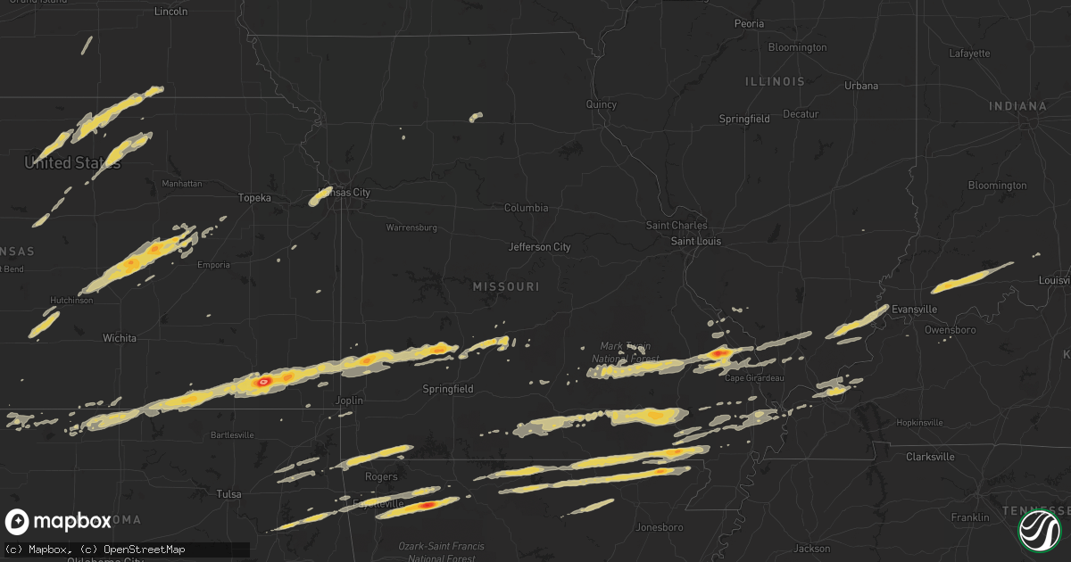
Hail Map on February 28, 2012
Get this storm
February 28 map
$229
one time, instant access
Download today. No call, no setup
Keep the $229
Bought the map and want the full workflow? Apply the entire $229 to a subscription within 7 days. None of it is wasted.
Every map, not just this one
This buys you this map. Subscription and you get every map we run, in the markets you choose from a few cities to whole states to nationwide. Plus real-time alerts the moment a storm fires.
Contact data
Name, contact info, occupancy, even credit band for addresses in the footprint. You go from where it hit to who to call.
Become the source they trust
Unlimited branding weather history reports on demand. You already have the documented answer ready for the property owner, and you are the one who showed up with it.
Property data and RoofTrace estimates
Pull up any address you have got, its value and the exact code rules for that jurisdiction, straight from One Click Code. Then RoofTrace estimates the squares, pitch, and roof value, priced the way you price.
States Impacted by Hail Map on February 28, 2012
Storm reports
Missouri
| Date | Description |
|---|---|
| 02/28/201211:48 AM CST | Golfball sized hail reported at fairgrounds. |
| 02/28/20125:20 AM CST | *** 1 inj *** emergency manager reporting widespread damage across the northern third of cape giradeau county. Manager is asking for no one to enter the area to allow e |
| 02/28/20124:50 AM CST | Possible tornado. Barn and chicken farm destroyed. House damaged. Widespread tree and power line damage along highway 408 near the intersection of hwy 403. Late report. |
| 02/28/20124:41 AM CST | Golf ball size hail reported near the community of neelyville. |
| 02/28/20124:30 AM CST | Numerous power outages with large amount of tree debris. Winds estimated 55 mph. |
| 02/28/20124:24 AM CST | Nws storm survey reveals an ef1 tornado which started just east of bell city in stoddard county to 3 miles southeast of benton in scott county. Details can be found in |
| 02/28/20124:18 AM CST | Line of damage from oak ridge to pocahantas missouri. Numerous structural and tree damage. Power outages. No injures reported at this time. Possible tornado. |
| 02/28/20124:15 AM CST | Em reports path of damage between ottawild and brownwood.late report. |
| 02/28/20124:00 AM CST | *** 1 inj *** emergency manager reporting widespread damage across the northern third of cape giradeau county. Manager is asking for no one to enter the area to allow e |
| 02/28/20124:00 AM CST | Nws storm damage survey reveals an ef3 tornado that started .5 miles west of asherville to 2 miles west of bell city. See pnspah for details. |
| 02/28/20123:59 AM CST | Numerous home stucture damage. Widespread trees and powerlines down. Damage observed by fire rescue teams and relayed to e0c. Possible tornado. No injuries reported at |
| 02/28/20123:49 AM CST | Barn blown away along highway 72 near the bollinger and cape girardeau county line. |
| 02/28/20123:41 AM CST | Power outages reported as well |
| 02/28/20123:33 AM CST | Ping pong size hail along highway v in town. Wind gust 30 to 40 mph associated with the storm. |
| 02/28/20123:30 AM CST | Antenna ripped off of home. Late report. |
| 02/28/20123:29 AM CST | Large tree uprooted..concrete wall blown over minor building damage |
| 02/28/20123:25 AM CST | 6-8 homes have roof damage along highway 72. 10 larger barns destroyed over a 5 mile area. Tree damage is widespread. Numerous power poles down. |
| 02/28/20123:11 AM CST | *** 1 inj *** 3 homes damaged... At least one with a roof missing and the others with siding removed. Another roof removed from barn. Several trees downed with diameter |
| 02/28/20123:11 AM CST | *** 1 inj *** 3 homes damaged... At least one with a roof missing and the others with siding removed. Another roof removed from barn. Several trees downed with diameter |
| 02/28/20122:49 AM CST | A local report indicates 60 MPH wind near WEST PLAINS |
| 02/28/20122:45 AM CST | Tree blown down...unknown size...blocking state hwy c east of annapolis |
| 02/28/20122:40 AM CST | Picture of hail relayed by broadcast media |
| 02/28/20122:39 AM CST | Power pole down |
| 02/28/20122:39 AM CST | A local report indicates 1.00 inch wind near LESTERVILLE |
| 02/28/20122:38 AM CST | A local report indicates 60 MPH wind near WHITE CHURCH |
| 02/28/20122:30 AM CST | A local report indicates 1.00 inch wind near POMONA |
| 02/28/20121:50 AM CST | Large oak tree down blocking hwy 49...one car ran into ditch...no injuries. Time estimated from radar. |
| 02/28/20121:45 AM CST | Ham radio esimated 60 to 70 mph wind gusts and nickel size hail. |
| 02/28/20121:45 AM CST | Ham radio reported estimated 60 mph wind gusts. |
| 02/28/20121:41 AM CST | Power lines down in cuba...also tree limbs down over us route 19. |
| 02/28/20121:35 AM CST | Large tree uprooted and several large sheds blown over on highland drive just north of cuba. |
| 02/28/20121:35 AM CST | Large billboard blown over onto highway zz just southwest of town...still blocking road. |
| 02/28/20121:35 AM CST | Mountain grove police department reported power lines down. |
| 02/28/20121:30 AM CST | Roof blown off gas station downtown branson possible tornado damage |
| 02/28/20121:29 AM CST | 20 homes destroyed. 20 damaged. |
| 02/28/20121:24 AM CST | Capri motor inn damaged. Wall of restaurant down. Sign down. Highwway patrol reports powerlines down across highway. |
| 02/28/20121:23 AM CST | Multiple trees reported down. Gas station reported damaged. Multiple service poles reported down. |
| 02/28/20121:23 AM CST | Roof blown off house and large trees down...possible tornado...near hwy 68 and hwy yy |
| 02/28/20121:20 AM CST | Multiple limbs of 4 to 5 inches down. |
| 02/28/20121:13 AM CST | *** 35 inj *** an ef-2 tornado tracked from from near kimberling city near joe bald road to 2 miles ese of kissee mills in taney county. Estimated max wind speeds of 12 |
| 02/28/20121:10 AM CST | Ham radio operator reported 60 mph wind gust |
| 02/28/20121:06 AM CST | An ef-1 rated tornado with a maximum wind speed of 90 to 95 mph tracked 19 miles from just northwest of edgar springs to the northeast to highway 68 just north of highw |
| 02/28/201212:59 AM CST | A local report indicates 75 MPH wind near 4 N FORDLAND |
| 02/28/201212:55 AM CST | Ham radio operator reported 60 mph wind gust. |
| 02/28/201212:52 AM CST | Large tree uprooted..concrete wall blown over minor building damage |
| 02/28/201212:52 AM CST | A local report indicates 65 MPH wind near ROGERSVILLE |
| 02/28/201212:52 AM CST | A local report indicates 60 MPH wind near NIXA |
| 02/28/201212:50 AM CST | Large tree blown down at the intersection of nicholas and mckenzie way |
| 02/28/201212:48 AM CST | A local report indicates 61 MPH wind near NIXA |
| 02/28/201212:40 AM CST | Nws employee reports a business sign blown down |
| 02/28/201212:33 AM CST | Reported by off duty nws meteorologist |
| 02/28/201212:30 AM CST | Machine shed blown over...tree limbs blown down...and fence blown down |
| 02/28/201212:30 AM CST | A local report indicates 1.75 inch wind near LEBANON |
| 02/28/201212:28 AM CST | Picture of hail relayed by broadcast media |
| 02/28/201212:28 AM CST | Tornado on the ground just sw of lebanon |
| 02/28/201212:25 AM CST | A local report indicates a tornado near 2 SW LEBANON |
| 02/28/201212:25 AM CST | A local report indicates 65 MPH wind near 1 E REPUBLIC |
| 02/28/201212:24 AM CST | A local report indicates 60 MPH wind near AURORA |
| 02/28/201212:22 AM CST | A brief tornado touchdown damaged around 20 recreational vehicles and an antique shop. |
| 02/28/201212:20 AM CST | Debris structure damage trees down power lines down near hwy 32 and hwy a sw of lebanon...also tracker trailers blown off i-44 from possible tornado |
| 02/28/201212:20 AM CST | Debris structure damage trees down power lines down near hwy 32 and hwy a sw of lebanon...also tracker trailers blown off i-44 from possible tornado |
| 02/28/201212:19 AM CST | Structural damage to 15 trailers rolled |
| 02/28/201212:18 AM CST | *** 1 inj *** an ef-1 magnitude tornado tracked from 2 miles northwest of phillipsburg to 1 mile southeast of lebanon several homes were damaged and trees uprooted. One |
| 02/28/201212:15 AM CST | Mcdonald county newspaper reported large limbs fell down on power lines which brought down power lines across the county causing power outages. |
| 02/28/201212:12 AM CST | Several trees blown over along state hwy e...damage to cars and home. Powerlines down over hwy 63 north of la plata |
| 02/28/201212:05 AM CST | Houses destroyed and major damage just sw of buffalo. Likely a tornado |
| 02/27/201211:58 PM CST | A nws survey indicated that an ef-1 tornado touched down near the polk and dallas county line. Another lsr will have more details on this track into dallas county. |
| 02/27/201211:56 PM CST | 1 house destroyed along with 3 turkey barns. Damage along wildlife rd. |
| 02/27/201211:50 PM CST | A local report indicates 1.75 inch wind near BOLIVAR |
| 02/27/201211:50 PM CST | Barn destroyed along hwy 215 on the east side of morrisville. Partial roof damage to a house. Debris in trees. |
| 02/27/201211:48 PM CST | Emergency management reports roof damage to a trailer and significant damage to a shed. |
| 02/27/201211:36 PM CST | A local report indicates 58 MPH wind near 2 SE LINNEUS |
| 02/27/201211:28 PM CST | Jasper county emergency management reports roof damage to a trailer. |
| 02/27/201211:26 PM CST | Windows blown out and barn destroyed |
| 02/27/201211:26 PM CST | An ef-1 rated tornado with a maximum wind speed of 90 to 100 mph tracked 18.6 miles from 3 miles north northwest of greenfield to 2 miles east southeast of aldrich. The |
| 02/27/201211:15 PM CST | Trees down. |
| 02/27/201211:15 PM CST | Possible debris path with structure damage to homes near hwy 71 just north of lamar |
| 02/27/201211:14 PM CST | Numerous trees and power lines down in lamar...possible damage with possible tornado |
| 02/27/201211:13 PM CST | Small hail |
| 02/27/201211:09 PM CST | A local report indicates 1.75 inch wind near 3 SW LAMAR |
| 02/27/201210:52 PM CST | An ef-1 rated tornado with maximum wind speed of 85 to 80 mph tracked 16 miles from 5 miles south southeast of mindenmines to 1 mile northwest of lamar crossing hwy 71. |
| 02/27/201210:46 PM CST | A local report indicates 70 MPH wind near 2 SE GLADSTONE |
| 02/27/201210:43 PM CST | Estimated near river market |
| 02/27/201210:43 PM CST | Two mobile homes blown over along with power lines down. 2 people trapped. |
| 02/27/201210:40 PM CST | 30 x 50 pole barn blown over. Nickel size hail. |
| 02/27/201210:25 PM CST | A local report indicates 60 MPH wind near 4 N GLADSTONE |
| 02/27/201210:25 PM CST | Roof blown off and wall pushed in on building under construction. |
| 02/27/201210:15 PM CST | A local report indicates 65 MPH wind near 5 E SMITHVILLE |
Arkansas
| Date | Description |
|---|---|
| 02/28/20125:15 AM CST | Siding and metal roof damage to a house. Trees uprooted along hwys 141 and 90. Barn damaged in area |
| 02/28/20125:00 AM CST | Spotter mentioned hail could have been bigger. |
| 02/28/20124:50 AM CST | A local report indicates 1.00 inch wind near STOKES |
| 02/28/20124:44 AM CST | A local report indicates 1.00 inch wind near ATTICA |
| 02/28/20124:30 AM CST | A local report indicates 1.00 inch wind near RAVENDEN SPRINGS |
| 02/28/20124:10 AM CST | Some tree debris was on local roadways. A wall cloud was reported as the storm went by. |
| 02/28/20123:25 AM CST | Hail ranged in size from penny to quarter. |
| 02/28/20123:25 AM CST | A local report indicates 1.00 inch wind near VIOLA |
| 02/28/20123:00 AM CST | A local report indicates 1.25 inch wind near MOUNTAIN HOME |
| 02/28/20122:20 AM CST | Relayed by knwa |
| 02/28/20122:14 AM CST | A local report indicates 1.50 inch wind near 2 SW KINGSTON |
| 02/28/20122:08 AM CST | A local report indicates 1.50 inch wind near AURORA |
| 02/28/20122:00 AM CST | A local report indicates 1.50 inch wind near 2 SW KINGSTON |
| 02/28/20121:21 AM CST | Estimated wind gusts to 60 mph and hail. Hail size unknown. |
| 02/28/201212:37 AM CST | 30 inch dia tree blown down. |
| 02/28/201212:22 AM CST | Large tree blown down across road on east side of town. |
Nebraska
| Date | Description |
|---|---|
| 02/28/20124:15 PM CST | Doors blown off of machine shed. Delayed report. |
| 02/28/20124:13 PM CST | Off duty nws employee reported a tornado 9 miles wsw of gandy. |
| 02/28/20124:13 PM CST | Reported a flipped center pivot unit 3w of the 83/92 junction. Tornado report was also in the vicinity. |
| 02/27/20127:30 PM CST | Outbuilding taken down by straight line winds at approximately 730 pm cst. |
| 02/27/20127:00 PM CST | Ef0 brief tornado in a field near intersection of 809 rd and 493 ave. Spotter witnessed the tornado from one half mile away and the tornado destroyed a pivot in the fie |
| 02/27/20126:49 PM CST | Irrigation pipe tossed and 3000 lb grinder overturned...estimated 60 mph wind. |
Illinois
| Date | Description |
|---|---|
| 02/28/20125:37 AM CST | Southeast portion of town experienced major damage. Possible one death but no comfirmed. Search and rescue in process at this time. |
| 02/28/20125:35 AM CST | Office of em reporting tornado near metropolis illinois. Seeing power flashes from transformers also. |
| 02/28/20125:25 AM CST | 60 plus mph winds reported and dime size hail |
| 02/28/20125:18 AM CST | Highway 45 is closed south of the community. |
| 02/28/20125:06 AM CST | Widespread trees and power lines down. Numerous homes and one church damaged. Late report. |
| 02/28/20125:03 AM CST | Possible tornado damage north and west of mounds and near exit 8 along interstate 57. Spotter had a cross arm ripped off a railroad sign and missled through his vehcile |
| 02/28/20125:00 AM CST | The ef2 tornado touched down just sw of mounds illinois and moved ene through mounds and crossed i-57 near exit 8. The tornado crossed the ohio river near the town of a |
| 02/28/20124:56 AM CST | Confirmed tornado by trained spotter. Approaching the south side of harrisburg. |
| 02/28/20124:56 AM CST | Electrical transformers flashing west of harrisburg. Possible tornado. |
| 02/28/20124:43 AM CST | Possible tornado. Power flashes south of marion illinois appears to be electrical transformers blowing up. |
| 02/28/20124:36 AM CST | Widespread power outages reported. |
| 02/28/20124:30 AM CST | Market street has solid garage destoryed. Trees down. Damage is in a path along the street. Late report. |
| 02/28/20124:22 AM CST | Quarter size hail. Power outages reported in the area. |
| 02/28/20122:35 AM CST | Roof damage to a barn reported in brushy mound township south of carlinville |
| 02/28/20122:35 AM CST | Roof damage and sheds blown down in between womac and barnett east of carlinville |
Oklahoma
| Date | Description |
|---|---|
| 02/28/201212:32 AM CST | Estimated wind gust 60 mph on south side of city |
| 02/27/201211:50 PM CST | A local report indicates 60 MPH wind near WYANDOTTE |
| 02/27/201211:46 PM CST | A local report indicates 60 MPH wind near 5 SW GROVE |
| 02/27/201211:30 PM CST | Roof damage and grill lifted off patio 2 miles east of miami on highway 10. |
| 02/27/201211:30 PM CST | Tree blown down. Also some tree limbs downed. |
| 02/27/201211:00 PM CST | Near 31st street and memorial...large signs damaged and destroyed. |
| 02/27/201211:00 PM CST | 58 mph measured gust at vinita mesonet |
| 02/27/201210:30 PM CST | Semi blown off roadway into center median. Driver transported to hospital with injuries. |
| 02/27/201210:25 PM CST | Tree limbs and large signs blown down and other debris in streets around town. |
| 02/27/201210:24 PM CST | 5th wheel trailer overturned and damage to carport just north of dewey. |
| 02/27/20128:45 PM CST | Estimated 70-80 mph gust |
| 02/27/20128:45 PM CST | A local report indicates 1.00 inch wind near BRAMAN |
| 02/27/20127:45 PM CST | A local report indicates 63 MPH wind near 1 SSW CHEROKEE |
Kentucky
| Date | Description |
|---|---|
| 02/28/20125:40 AM CST | A few barns and a machine shed blown down. Porch blown off of home. |
| 02/28/20125:20 AM CST | *** 5 inj *** mobile home destoryed along ogden landing road. Late report.update...a mix of 6 homes/mobile homes damaged/destoryed. 5 injuries reported with 1 serious. |
| 02/28/20125:20 AM CST | Mobile home destoryed along ogden landing road. Late report. |
| 02/28/20125:18 AM CST | Late report...possible tornado. Damage path between bandana and ragsdale. 1 mobile home and 1 farm destroyed near bandana. 1 mobile home destoryed in ragsdale along osc |
| 02/28/20125:16 AM CST | Power pole snapped and laying across a mobile home. Individuals trapped inside. Wind gusts estimated 60 mph. No injuries reported at this time. |
| 02/28/20121:56 AM CST | Tree down on morning branch road. Time estimated from radar. |
| 02/28/20121:42 AM CST | Tree down on udel branch road. |
Indiana
| Date | Description |
|---|---|
| 02/27/201211:13 PM CST | A local report indicates 1.00 inch wind near WADESVILLE |
Kansas
| Date | Description |
|---|---|
| 02/28/20125:38 PM CST | Possible tornado...six trees tops sheared off...uprooted tree...limbs across the road |
| 02/28/20125:38 PM CST | Ef0 tornado confirmed in far northwest cloud county via damage reports from survey team and multiple public reports. Tornado likely entered from the jewell-cloud county |
| 02/28/20125:38 PM CST | Possible tornado...2 large trees uprooted...tin wrapped around trees...10x40 metal building destroyed...cars damaged by flying debris...partial barn roof damaged...dela |
| 02/28/20125:30 PM CST | Damage to out buildings and house. Power polls broken and fell on c road between roads 290 and 300. Half inch hail was also reported. |
| 02/28/20125:28 PM CST | Ef0 tornado tracked for two miles from 5 miles southeast of randall to 6 miles east-southeast of randall. One farm struck...with damage including metal roof torn off ou |
| 02/27/201211:21 PM CST | A local report indicates 70 MPH wind near NEUTRAL |
| 02/27/201210:58 PM CST | A national weather service storm survey determined that straight-line winds of 100 to 120 miles per hour occured near pittsburg kansas...creating a one mile path of dam |
| 02/27/201210:55 PM CST | Three tall wooden power poles snapped at the base on s 260th st one mile north of e 530th ave. Heavy structural damage to house at same location. |
| 02/27/201210:55 PM CST | Structural damage and lots of trees down near 200th and 510th street southwest of pittsburg...possible tornado damage |
| 02/27/201210:52 PM CST | A local report indicates 70 MPH wind near MCCUNE |
| 02/27/201210:48 PM CST | A local report indicates 70 MPH wind near 1 W PITTSBURG |
| 02/27/201210:48 PM CST | A local report indicates 65 MPH wind near 1 N FRONTENAC |
| 02/27/201210:42 PM CST | Douglas ave |
| 02/27/201210:42 PM CST | A local report indicates 1.00 inch wind near 1 S PITTSBURG |
| 02/27/201210:37 PM CST | A local report indicates 70 MPH wind near 2 W WEST MINERAL |
| 02/27/201210:36 PM CST | Emergency management reports six large wood high voltage power polls down and damage to a barn. |
| 02/27/201210:36 PM CST | A local report indicates 1.25 inch wind near 1 SW MCCUNE |
| 02/27/201210:36 PM CST | Two out buildings destroyed with one having its foundation anchors pulled out. |
| 02/27/201210:33 PM CST | A local report indicates 60 MPH wind near 1 SW MCCUNE |
| 02/27/201210:30 PM CST | Emergency management reports two barns destroyed and one with significant damage. |
| 02/27/201210:24 PM CST | Pea sized hail and heavy rain also reported |
| 02/27/201210:24 PM CST | Several shingles removed from a house. |
| 02/27/201210:23 PM CST | A local report indicates 70 MPH wind near PARSONS |
| 02/27/201210:23 PM CST | A local report indicates 1.50 inch wind near 1 W PARSONS |
| 02/27/201210:22 PM CST | A local report indicates 70 MPH wind near 3 W ST. PAUL |
| 02/27/201210:22 PM CST | Several reports of damage across labette county and some injuries. Specifics unknown at this time. |
| 02/27/201210:21 PM CST | Metal roofing of an apartment rolled up. |
| 02/27/201210:19 PM CST | 62 mph wind gusts measured on weather lab site. |
| 02/27/201210:19 PM CST | A local report indicates 1.75 inch wind near PARSONS |
| 02/27/201210:11 PM CST | Ef0 tornado confirmed by douglas county emergency management survey and other public reports. Path of tornado from 4 s globe in northern franklin county...to 1.5 s word |
| 02/27/201210:07 PM CST | 59 mph wind gusts measured at a weatherlab site. |
| 02/27/201210:06 PM CST | Measured at ixd. |
| 02/27/201210:05 PM CST | Hail to walnut size also occurred and windows were broken out in several homes. |
| 02/27/201210:05 PM CST | A local report indicates 61 MPH wind near 7 SW OLATHE |
| 02/27/201210:05 PM CST | 4 to 5 inch diameter tree limbs downed. Windows also broken in homes due to wind driven hail. |
| 02/27/201210:05 PM CST | Delayed report of a roof peeled off of a barn near le roy. Time estimated from radar. |
| 02/27/201210:05 PM CST | Delayed report of 2 barns and numerous outbuildings destroyed and vehicle damage near centropolis. Time estimated from radar. |
| 02/27/201210:05 PM CST | A local report indicates 3.00 inch wind near CHERRYVALE |
| 02/27/201210:03 PM CST | On south side of town. |
| 02/27/201210:03 PM CST | A local report indicates 1.50 inch wind near INDEPENDENCE |
| 02/27/201210:02 PM CST | Estimated wind gusts to 50 mph |
| 02/27/20129:57 PM CST | Estimated 50 to 55 mph with gusts to 60 |
| 02/27/20129:57 PM CST | Several large trees 3 feet in diameter blown down. Reported both south and northwest of town. |
| 02/27/20129:56 PM CST | A house was destroyed. Rescuers were still trying to get a family out of the debris. Time of occurrence estimated via doppler radar. |
| 02/27/20129:56 PM CST | A local report indicates 60 MPH wind near S LYNDON |
| 02/27/20129:53 PM CST | A local report indicates 67 MPH wind near 1 SW OSAGE CITY |
| 02/27/20129:47 PM CST | A local report indicates 61 MPH wind near LAWRENCE |
| 02/27/20129:44 PM CST | Live tree blown down |
| 02/27/20129:42 PM CST | A local report indicates 58 MPH wind near EUREKA |
| 02/27/20129:35 PM CST | A local report indicates 1.00 inch wind near 4 SSW LECOMPTON |
| 02/27/20129:30 PM CST | A house was severely damaged at 80th street and oxford road. |
| 02/27/20129:30 PM CST | In southeast sumner county the following damage was reported. House lost 2/3 of roof...1 wall bowed out 2 feet...1 large tree uprooted...several power poles blown down |
| 02/27/20129:22 PM CST | Hail to 1.5 inch in diameter also accompanied the severe wind gusts. |
| 02/27/20129:22 PM CST | Wind gusts to 80 mph accompanied the large hail. |
| 02/27/20129:19 PM CST | At 29th and oakley |
| 02/27/20129:19 PM CST | Several power poles were knocked down. |
| 02/27/20129:07 PM CST | A local report indicates 65 MPH wind near DEXTER |
| 02/27/20129:03 PM CST | Heavy structural damage to homes and church building in harveyville due to possible tornado. Reports of people trapped in structures. Time estimated based on radar. |
| 02/27/20129:02 PM CST | Preliminary information from incident command...possible tornado...1 critical injury...several minor injuries...numerous homes destroyed...all people accounted for in t |
| 02/27/20129:02 PM CST | Large trees reported down on home. Time estimated |
| 02/27/20129:02 PM CST | At least six power poles were blown down 5 miles east and 2.5 miles south of leon. This damage extended to the northeast of this location by around 2 miles. |
| 02/27/20128:59 PM CST | A local report indicates 60 MPH wind near WINFIELD |
| 02/27/20128:59 PM CST | A local report indicates 60 MPH wind near STROTHER FIELD AIRPORT |
| 02/27/20128:57 PM CST | Turnpike gate in west el dorado. |
| 02/27/20128:55 PM CST | 35-45 mph winds |
| 02/27/20128:55 PM CST | The wind gust occurred at 21st road and highway 160. |
| 02/27/20128:48 PM CST | A local report indicates 58 MPH wind near ARKANSAS CITY |
| 02/27/20128:46 PM CST | A local report indicates 60 MPH wind near GEUDA SPRINGS |
| 02/27/20128:45 PM CST | 8-10 inch tree down. |
| 02/27/20128:43 PM CST | A local report indicates 79 MPH wind near 7 W ARKANSAS CITY |
| 02/27/20128:40 PM CST | In extreme southeast sumner county the following damage was reported. House lost 2/3 of roof...1 wall bowed out 2 feet...1 large tree uprooted...and a concrete block ga |
| 02/27/20128:30 PM CST | In southeast sumner county the following damage was reported. House lost 2/3 of roof...1 wall bowed out 2 feet...1 large tree uprooted...several power poles blown down |
| 02/27/20128:25 PM CST | A local report indicates 1.00 inch wind near 6 SW COUNCIL GROVE |
| 02/27/20128:20 PM CST | A local report indicates 1.50 inch wind near 6 W COUNCIL GROVE |
| 02/27/20128:20 PM CST | A local report indicates 1.00 inch wind near WILSEY |
| 02/27/20128:19 PM CST | Several power poles were knocked down. |
| 02/27/20127:57 PM CST | Also reported 60 mph wind gusts |
| 02/27/20127:50 PM CST | Amateur radio marion co 1/2 dollar size hail on the north side of marion reservoir. |
| 02/27/20127:50 PM CST | Power lines blown down. Time of occurrence estimated based on doppler radar imagery. |
| 02/27/20127:43 PM CST | Report of barn blown into the road in southwestern sumner county. No injuries reported. |
| 02/27/20127:43 PM CST | A local report indicates 62 MPH wind near 2 W BENTON |
| 02/27/20127:30 PM CST | Wind damage to a storage unit located at the intersection of steadman and pennsylvania. |
| 02/27/20127:28 PM CST | Storm spotters and deputies reporting golf ball sized hail and winds approx 70mph north of hillsboro on k-15. |
| 02/27/20127:22 PM CST | 2 to 4 inch diameter tree limbs were downed. |
| 02/27/20127:20 PM CST | A local report indicates 60 MPH wind near W CLIFTON |
| 02/27/20127:20 PM CST | New pivot irrigation system blown over. Time of event based on doppler radar imagery. |
| 02/27/20127:17 PM CST | Trained spotter reported two large post signs twisted 22 degrees and exit 48 on interstate 135 on the north end of moundridge severely fractured. Other wooden sign post |
| 02/27/20127:15 PM CST | Also reported dime size hail |
| 02/27/20126:43 PM CST | Storm chaser reported a tornado lasting about 5 minutes from 643 to 648 pm. |
| 02/27/20126:30 PM CST | Delayed report...spotter estimated 60 mph winds around 630 pm cst...hail broke outside light...size unknown |
| 02/27/20126:30 PM CST | Damage to out buildings and house. Power polls broken and fell on c road between roads 290 and 300. Half inch hail was also reported. |
| 02/27/20126:09 PM CST | Farm sheds damaged...delayed report |
| 02/27/20126:07 PM CST | Power lines down in belleville. |
| 02/27/20126:06 PM CST | Power poles and trees blown down on the east side of belleville...delayed report |
| 02/27/20126:02 PM CST | Some roofs of outbuildings blown off |
Cities Impacted by Hail Map on February 28, 2012
- Seligman, MO
- Salina, OK
- Eucha, OK
- Spavinaw, OK
- Pryor, OK
- Barnard, KS
- Minneapolis, KS
- Lincoln, KS
- Augusta, KY
- Germantown, KY
- Brooksville, KY
- Alva, OK
- Lincoln, AR
- Fayetteville, AR
- Farmington, AR
- Prairie Grove, AR
- Springdale, AR
- Nash, OK
- Medford, OK
- Wakita, OK
- Walnut Grove, MO
- Morrisville, MO
- Bolivar, MO
- Huntsville, AR
- Kingston, AR
- Harrison, AR
- Qulin, MO
- Lakeview, AR
- Gamaliel, AR
- Mammoth Spring, AR
- Cotter, AR
- Corning, AR
- Myrtle, MO
- Couch, MO
- Sturkie, AR
- Oxly, MO
- Campbell, MO
- Gassville, AR
- Yellville, AR
- Neelyville, MO
- Gatewood, MO
- Maynard, AR
- Thayer, MO
- Naylor, MO
- Henderson, AR
- Ravenden, AR
- Midway, AR
- Gepp, AR
- Broseley, MO
- Elizabeth, AR
- Pocahontas, AR
- Doniphan, MO
- Bull Shoals, AR
- Warm Springs, AR
- Viola, AR
- Success, AR
- Flippin, AR
- Mountain Home, AR
- Salem, AR
- Harviell, MO
- Bernie, MO
- Poplar Bluff, MO
- Camp, AR
- Dudley, MO
- Fisk, MO
- Turon, KS
- Canton, KS
- Moundridge, KS
- Galva, KS
- Hillsboro, KS
- Jamestown, KS
- Concordia, KS
- Norway, KS
- Belleville, KS
- Haddam, KS
- Morrowville, KS
- Mahaska, KS
- Scandia, KS
- Cuba, KS
- Narka, KS
- Old Appleton, MO
- Oak Ridge, MO
- Kevil, KY
- West Paducah, KY
- Annapolis, MO
- Fredericktown, MO
- Arcadia, MO
- Willow Springs, MO
- Pomona, MO
- Dora, MO
- West Plains, MO
- Wasola, MO
- Mountain View, MO
- Vanzant, MO
- Pottersville, MO
- Brixey, MO
- Gainesville, MO
- Winona, MO
- Ava, MO
- Zanoni, MO
- Drury, MO
- Birch Tree, MO
- Liberal, MO
- Stilwell, OK
- Welling, OK
- Proctor, OK
- Tahlequah, OK
- Ellsinore, MO
- Grandin, MO
- Van Buren, MO
- Williamsville, MO
- Fremont, MO
- Cherryvale, KS
- Golconda, IL
- Brookport, IL
- Marble Hill, MO
- Palmer, KS
- Greenleaf, KS
- Clifton, KS
- Linn, KS
- Lamar, MO
- Maple City, KS
- Dexter, KS
- Elk City, KS
- Dennis, KS
- Mound Valley, KS
- McCune, KS
- Liberty, KS
- Parsons, KS
- Independence, KS
- Arkansas City, KS
- Oswego, KS
- Sedan, KS
- Cedar Vale, KS
- Havana, KS
- Green Forest, AR
- Compton, AR
- Witter, AR
- Wesley, AR
- West Fork, AR
- Elkins, AR
- Marble Falls, AR
- Horseshoe Bend, AR
- Cherokee Village, AR
- Oxford, AR
- Hardy, AR
- Ash Flat, AR
- Shidler, OK
- Frontenac, KS
- Mindenmines, MO
- Lockwood, MO
- Saint Paul, KS
- Newkirk, OK
- Weir, KS
- Girard, KS
- Oronogo, MO
- Fair Play, MO
- Buffalo, MO
- Dadeville, MO
- Arcola, MO
- Brighton, MO
- Golden City, MO
- Coffeyville, KS
- Jasper, MO
- Half Way, MO
- Greenfield, MO
- Aldrich, MO
- Asbury, MO
- Pittsburg, KS
- Jerico Springs, MO
- Altamont, KS
- Cherokee, KS
- Herington, KS
- Burdick, KS
- Lost Springs, KS
- Lincolnville, KS
- Steele City, NE
- Odell, NE
- Diller, NE
- Jewell, KS
- Randall, KS
- Glen Elder, KS
- Beloit, KS
- Redford, MO
- Ellington, MO
- Lesterville, MO
- Centerville, MO
- Salem, MO
- Burna, KY
- Marion, KY
- Salem, KY
- Welch, OK
- Raymondville, MO
- Lebanon, MO
- Miami, OK
- Mill Spring, MO
- Alton, MO
- Jonesboro, IL
- Wolf Lake, IL
- Bunker, MO
- Cobden, IL
- Daisy, MO
- Des Arc, MO
- Cape Girardeau, MO
- Millersville, MO
- Altenburg, MO
- Burfordville, MO
- Sedgewickville, MO
- Jackson, MO
- Patton, MO
- Anna, IL
- Uniontown, MO
- Marquand, MO
- Perryville, MO
- Frohna, MO
- Friedheim, MO
- Cunningham, KS
- Arlington, KS
- Partridge, KS
- Peace Valley, MO
- Washburn, MO
- Bella Vista, AR
- Pineville, MO
- Gravette, AR
- Eagle Rock, MO
- Sulphur Springs, AR
- Cassville, MO
- Noel, MO
- Bluff City, KS
- Council Grove, KS
- Fairbury, NE
- Endicott, NE
- Hollenberg, KS
- Agenda, KS
- Munden, KS
- Courtland, KS
- Pollard, AR
- Piggott, AR
- Ghent, KY
- Vevay, IN
- Strong City, KS
- Charleston, MO
- Sikeston, MO
- Bertrand, MO
- Matthews, MO
- Essex, MO
- Dexter, MO
- Bell City, MO
- Milton, KY
- Madison, IN
- Bedford, KY
- Carrollton, KY
- Owenton, KY
- Hardinsburg, IN
- Marengo, IN
- Chester, IL
- Steeleville, IL
- Abbyville, KS
- Morganville, KS
- Miltonvale, KS
- Clyde, KS
- Harrisburg, IL
- Eldorado, IL
- Equality, IL
- Ridgway, IL
- Elkland, MO
- Long Lane, MO
- Phillipsburg, MO
- Wilsey, KS
- Florence, KS
- Marion, KS
- Mount Vernon, IN
- Lehigh, KS
- Tampa, KS
- Alto Pass, IL
- Carbondale, IL
- Makanda, IL
- Pomona, IL
- Grand Tower, IL
- Marion, IL
- Metropolis, IL
- Smithland, KY
- Peabody, KS
- Biggers, AR
- Conway, MO
- Alma, KS
- Allen, KS
- Ravenden Springs, AR
- Ferdinand, IN
- Dale, IN
- Saint Anthony, IN
- Boonville, IN
- Birdseye, IN
- Lynnville, IN
- Huntingburg, IN
- Stendal, IN
- Holland, IN
- Tennyson, IN
- Eckerty, IN
- Byars, OK
- Jay, OK
- Bucklin, MO
- Cherokee, OK
- Black Rock, AR
- Poughkeepsie, AR
- Evening Shade, AR
- Cave City, AR
- Sidney, AR
- Smithville, AR
- Braman, OK
- Ellsworth, KS
- Wilson, KS
- Stoutland, MO
- Eskridge, KS
- Datto, AR
- Brookfield, MO
- Chetopa, KS
- Kansas City, KS
- Shawnee, KS
- De Soto, KS
- Linwood, KS
- Lenexa, KS
- Bonner Springs, KS
- Parma, MO
- Amorita, OK
- Knobel, AR
- Imboden, AR
- Wiseman, AR
- Wideman, AR
- Williford, AR
- Glencoe, AR
- Berryville, AR
- Ponca, AR
- Inman, KS
- Durham, KS
- Buhler, KS
- Mcpherson, KS
- Perryville, AR
- Fair Grove, MO
- Norfork, AR
- Dolph, AR
- Calico Rock, AR
- Advance, MO
- Benton, MO
- Oran, MO
- Omaha, IL
- Junction, IL
- New Haven, IL
- Grovespring, MO
- Scammon, KS
- Columbus, KS
- Westville, OK
- Summers, AR
- Carmi, IL
- Carrier Mills, IL
- Henderson, KY
- Corydon, KY
- Pekin, IN
- Big Cabin, OK
- Adair, OK
- Taswell, IN
- Gentryville, IN
- Williamsburg, KS
- Williamstown, KY
- Falmouth, KY
- Blackwell, OK
- Nardin, OK
- South Haven, KS
- Hulbert, OK
- Muskogee, OK
- Fort Gibson, OK
- Saint Mary, MO
- Siloam Springs, AR
- Watts, OK
- Neodesha, KS
- Laquey, MO
- Falcon, MO
- Mound City, KS
- Ramona, KS
- Deer Creek, OK
- Peru, KS
- Thayer, KS
- Galesburg, KS
- Shickley, NE
- Geneva, NE
- Dover, KY
- Maysville, KY
- Puxico, MO
- Hutchinson, KS
- Alta Vista, KS
- Dwight, KS
- Lecompton, KS
- Burlington, OK
- Bradleyville, MO
- Afton, OK
- Vinita, OK
- Strang, OK
- Owensboro, KY
- Alpena, AR
- Hindsville, AR
- Rector, AR
- Broken Bow, NE
- Callaway, NE
- Hampton, KY
- Yukon, MO
- Seneca, MO
- Joplin, MO
- Neosho, MO
- Quapaw, OK
- Mountain Grove, MO
- Cabool, MO
- Houston, MO
- Paducah, KY
- Tiline, KY
- Rantoul, KS
- Ottawa, KS
- Squires, MO
- Plainview, AR
- Braymer, MO
- Medicine Lodge, KS
- Stapleton, NE
- Caldwell, KS
- La Center, KY
- Wickliffe, KY
- Graff, MO
- Black, MO
- Buncombe, IL
- Paoli, IN
- English, IN
- Mount Pleasant, AR
- Lawrence, KS
- White City, KS
- Belleview, MO
- Herod, IL
- Shawneetown, IL
- Sainte Genevieve, MO
- Eureka, KS
- Percy, IL
- Bixby, MO
- Manchester, OK
- Washington, KS
- Pleasant Hope, MO
- Noble, MO
- Everton, AR
- Everton, MO
- Ozark, IL
- Goreville, IL
- Bloomfield, MO
- Sanders, KY
- Warsaw, KY
- Delphos, KS
- Aurora, KS
- Clay Center, KS
- Eldridge, MO
- Hartshorn, MO