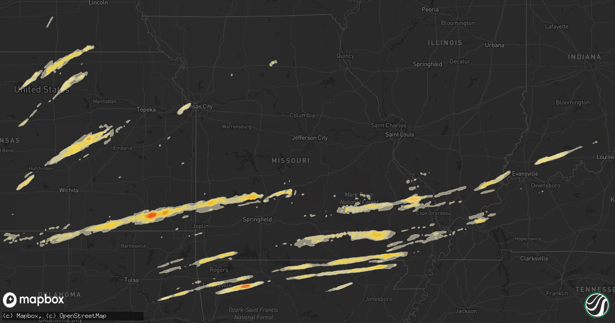
Hail Map in Illinois on February 28, 2012
Get this storm
February 28 map
$229
one time, instant access
Download today. No call, no setup
Keep the $229
Bought the map and want the full workflow? Apply the entire $229 to a subscription within 7 days. None of it is wasted.
Every map, not just this one
This buys you this map. Subscription and you get every map we run, in the markets you choose from a few cities to whole states to nationwide. Plus real-time alerts the moment a storm fires.
Contact data
Name, contact info, occupancy, even credit band for addresses in the footprint. You go from where it hit to who to call.
Become the source they trust
Unlimited branding weather history reports on demand. You already have the documented answer ready for the property owner, and you are the one who showed up with it.
Property data and RoofTrace estimates
Pull up any address you have got, its value and the exact code rules for that jurisdiction, straight from One Click Code. Then RoofTrace estimates the squares, pitch, and roof value, priced the way you price.
Storm reports in Illinois
Illinois
| Date | Description |
|---|---|
| 02/28/20125:37 AM CST | Southeast portion of town experienced major damage. Possible one death but no comfirmed. Search and rescue in process at this time. |
| 02/28/20125:35 AM CST | Office of em reporting tornado near metropolis illinois. Seeing power flashes from transformers also. |
| 02/28/20125:25 AM CST | 60 plus mph winds reported and dime size hail |
| 02/28/20125:18 AM CST | Highway 45 is closed south of the community. |
| 02/28/20125:06 AM CST | Widespread trees and power lines down. Numerous homes and one church damaged. Late report. |
| 02/28/20125:03 AM CST | Possible tornado damage north and west of mounds and near exit 8 along interstate 57. Spotter had a cross arm ripped off a railroad sign and missled through his vehcile |
| 02/28/20125:00 AM CST | The ef2 tornado touched down just sw of mounds illinois and moved ene through mounds and crossed i-57 near exit 8. The tornado crossed the ohio river near the town of a |
| 02/28/20124:56 AM CST | Confirmed tornado by trained spotter. Approaching the south side of harrisburg. |
| 02/28/20124:56 AM CST | Electrical transformers flashing west of harrisburg. Possible tornado. |
| 02/28/20124:43 AM CST | Possible tornado. Power flashes south of marion illinois appears to be electrical transformers blowing up. |
| 02/28/20124:36 AM CST | Widespread power outages reported. |
| 02/28/20124:30 AM CST | Market street has solid garage destoryed. Trees down. Damage is in a path along the street. Late report. |
| 02/28/20124:22 AM CST | Quarter size hail. Power outages reported in the area. |
| 02/28/20122:35 AM CST | Roof damage to a barn reported in brushy mound township south of carlinville |
| 02/28/20122:35 AM CST | Roof damage and sheds blown down in between womac and barnett east of carlinville |
All States Impacted by Hail Map on February 28, 2012
Cities Impacted by Hail Map on February 28, 2012
- Seligman, MO
- Salina, OK
- Eucha, OK
- Spavinaw, OK
- Pryor, OK
- Barnard, KS
- Minneapolis, KS
- Lincoln, KS
- Augusta, KY
- Germantown, KY
- Brooksville, KY
- Alva, OK
- Lincoln, AR
- Fayetteville, AR
- Farmington, AR
- Prairie Grove, AR
- Springdale, AR
- Nash, OK
- Medford, OK
- Wakita, OK
- Walnut Grove, MO
- Morrisville, MO
- Bolivar, MO
- Huntsville, AR
- Kingston, AR
- Harrison, AR
- Qulin, MO
- Lakeview, AR
- Gamaliel, AR
- Mammoth Spring, AR
- Cotter, AR
- Corning, AR
- Myrtle, MO
- Couch, MO
- Sturkie, AR
- Oxly, MO
- Campbell, MO
- Gassville, AR
- Yellville, AR
- Neelyville, MO
- Gatewood, MO
- Maynard, AR
- Thayer, MO
- Naylor, MO
- Henderson, AR
- Ravenden, AR
- Midway, AR
- Gepp, AR
- Broseley, MO
- Elizabeth, AR
- Pocahontas, AR
- Doniphan, MO
- Bull Shoals, AR
- Warm Springs, AR
- Viola, AR
- Success, AR
- Flippin, AR
- Mountain Home, AR
- Salem, AR
- Harviell, MO
- Bernie, MO
- Poplar Bluff, MO
- Camp, AR
- Dudley, MO
- Fisk, MO
- Turon, KS
- Canton, KS
- Moundridge, KS
- Galva, KS
- Hillsboro, KS
- Jamestown, KS
- Concordia, KS
- Norway, KS
- Belleville, KS
- Haddam, KS
- Morrowville, KS
- Mahaska, KS
- Scandia, KS
- Cuba, KS
- Narka, KS
- Old Appleton, MO
- Oak Ridge, MO
- Kevil, KY
- West Paducah, KY
- Annapolis, MO
- Fredericktown, MO
- Arcadia, MO
- Willow Springs, MO
- Pomona, MO
- Dora, MO
- West Plains, MO
- Wasola, MO
- Mountain View, MO
- Vanzant, MO
- Pottersville, MO
- Brixey, MO
- Gainesville, MO
- Winona, MO
- Ava, MO
- Zanoni, MO
- Drury, MO
- Birch Tree, MO
- Liberal, MO
- Stilwell, OK
- Welling, OK
- Proctor, OK
- Tahlequah, OK
- Ellsinore, MO
- Grandin, MO
- Van Buren, MO
- Williamsville, MO
- Fremont, MO
- Cherryvale, KS
- Golconda, IL
- Brookport, IL
- Marble Hill, MO
- Palmer, KS
- Greenleaf, KS
- Clifton, KS
- Linn, KS
- Lamar, MO
- Maple City, KS
- Dexter, KS
- Elk City, KS
- Dennis, KS
- Mound Valley, KS
- McCune, KS
- Liberty, KS
- Parsons, KS
- Independence, KS
- Arkansas City, KS
- Oswego, KS
- Sedan, KS
- Cedar Vale, KS
- Havana, KS
- Green Forest, AR
- Compton, AR
- Witter, AR
- Wesley, AR
- West Fork, AR
- Elkins, AR
- Marble Falls, AR
- Horseshoe Bend, AR
- Cherokee Village, AR
- Oxford, AR
- Hardy, AR
- Ash Flat, AR
- Shidler, OK
- Frontenac, KS
- Mindenmines, MO
- Lockwood, MO
- Saint Paul, KS
- Newkirk, OK
- Weir, KS
- Girard, KS
- Oronogo, MO
- Fair Play, MO
- Buffalo, MO
- Dadeville, MO
- Arcola, MO
- Brighton, MO
- Golden City, MO
- Coffeyville, KS
- Jasper, MO
- Half Way, MO
- Greenfield, MO
- Aldrich, MO
- Asbury, MO
- Pittsburg, KS
- Jerico Springs, MO
- Altamont, KS
- Cherokee, KS
- Herington, KS
- Burdick, KS
- Lost Springs, KS
- Lincolnville, KS
- Steele City, NE
- Odell, NE
- Diller, NE
- Jewell, KS
- Randall, KS
- Glen Elder, KS
- Beloit, KS
- Redford, MO
- Ellington, MO
- Lesterville, MO
- Centerville, MO
- Salem, MO
- Burna, KY
- Marion, KY
- Salem, KY
- Welch, OK
- Raymondville, MO
- Lebanon, MO
- Miami, OK
- Mill Spring, MO
- Alton, MO
- Jonesboro, IL
- Wolf Lake, IL
- Bunker, MO
- Cobden, IL
- Daisy, MO
- Des Arc, MO
- Cape Girardeau, MO
- Millersville, MO
- Altenburg, MO
- Burfordville, MO
- Sedgewickville, MO
- Jackson, MO
- Patton, MO
- Anna, IL
- Uniontown, MO
- Marquand, MO
- Perryville, MO
- Frohna, MO
- Friedheim, MO
- Cunningham, KS
- Arlington, KS
- Partridge, KS
- Peace Valley, MO
- Washburn, MO
- Bella Vista, AR
- Pineville, MO
- Gravette, AR
- Eagle Rock, MO
- Sulphur Springs, AR
- Cassville, MO
- Noel, MO
- Bluff City, KS
- Council Grove, KS
- Fairbury, NE
- Endicott, NE
- Hollenberg, KS
- Agenda, KS
- Munden, KS
- Courtland, KS
- Pollard, AR
- Piggott, AR
- Ghent, KY
- Vevay, IN
- Strong City, KS
- Charleston, MO
- Sikeston, MO
- Bertrand, MO
- Matthews, MO
- Essex, MO
- Dexter, MO
- Bell City, MO
- Milton, KY
- Madison, IN
- Bedford, KY
- Carrollton, KY
- Owenton, KY
- Hardinsburg, IN
- Marengo, IN
- Chester, IL
- Steeleville, IL
- Abbyville, KS
- Morganville, KS
- Miltonvale, KS
- Clyde, KS
- Harrisburg, IL
- Eldorado, IL
- Equality, IL
- Ridgway, IL
- Elkland, MO
- Long Lane, MO
- Phillipsburg, MO
- Wilsey, KS
- Florence, KS
- Marion, KS
- Mount Vernon, IN
- Lehigh, KS
- Tampa, KS
- Alto Pass, IL
- Carbondale, IL
- Makanda, IL
- Pomona, IL
- Grand Tower, IL
- Marion, IL
- Metropolis, IL
- Smithland, KY
- Peabody, KS
- Biggers, AR
- Conway, MO
- Alma, KS
- Allen, KS
- Ravenden Springs, AR
- Ferdinand, IN
- Dale, IN
- Saint Anthony, IN
- Boonville, IN
- Birdseye, IN
- Lynnville, IN
- Huntingburg, IN
- Stendal, IN
- Holland, IN
- Tennyson, IN
- Eckerty, IN
- Byars, OK
- Jay, OK
- Bucklin, MO
- Cherokee, OK
- Black Rock, AR
- Poughkeepsie, AR
- Evening Shade, AR
- Cave City, AR
- Sidney, AR
- Smithville, AR
- Braman, OK
- Ellsworth, KS
- Wilson, KS
- Stoutland, MO
- Eskridge, KS
- Datto, AR
- Brookfield, MO
- Chetopa, KS
- Kansas City, KS
- Shawnee, KS
- De Soto, KS
- Linwood, KS
- Lenexa, KS
- Bonner Springs, KS
- Parma, MO
- Amorita, OK
- Knobel, AR
- Imboden, AR
- Wiseman, AR
- Wideman, AR
- Williford, AR
- Glencoe, AR
- Berryville, AR
- Ponca, AR
- Inman, KS
- Durham, KS
- Buhler, KS
- Mcpherson, KS
- Perryville, AR
- Fair Grove, MO
- Norfork, AR
- Dolph, AR
- Calico Rock, AR
- Advance, MO
- Benton, MO
- Oran, MO
- Omaha, IL
- Junction, IL
- New Haven, IL
- Grovespring, MO
- Scammon, KS
- Columbus, KS
- Westville, OK
- Summers, AR
- Carmi, IL
- Carrier Mills, IL
- Henderson, KY
- Corydon, KY
- Pekin, IN
- Big Cabin, OK
- Adair, OK
- Taswell, IN
- Gentryville, IN
- Williamsburg, KS
- Williamstown, KY
- Falmouth, KY
- Blackwell, OK
- Nardin, OK
- South Haven, KS
- Hulbert, OK
- Muskogee, OK
- Fort Gibson, OK
- Saint Mary, MO
- Siloam Springs, AR
- Watts, OK
- Neodesha, KS
- Laquey, MO
- Falcon, MO
- Mound City, KS
- Ramona, KS
- Deer Creek, OK
- Peru, KS
- Thayer, KS
- Galesburg, KS
- Shickley, NE
- Geneva, NE
- Dover, KY
- Maysville, KY
- Puxico, MO
- Hutchinson, KS
- Alta Vista, KS
- Dwight, KS
- Lecompton, KS
- Burlington, OK
- Bradleyville, MO
- Afton, OK
- Vinita, OK
- Strang, OK
- Owensboro, KY
- Alpena, AR
- Hindsville, AR
- Rector, AR
- Broken Bow, NE
- Callaway, NE
- Hampton, KY
- Yukon, MO
- Seneca, MO
- Joplin, MO
- Neosho, MO
- Quapaw, OK
- Mountain Grove, MO
- Cabool, MO
- Houston, MO
- Paducah, KY
- Tiline, KY
- Rantoul, KS
- Ottawa, KS
- Squires, MO
- Plainview, AR
- Braymer, MO
- Medicine Lodge, KS
- Stapleton, NE
- Caldwell, KS
- La Center, KY
- Wickliffe, KY
- Graff, MO
- Black, MO
- Buncombe, IL
- Paoli, IN
- English, IN
- Mount Pleasant, AR
- Lawrence, KS
- White City, KS
- Belleview, MO
- Herod, IL
- Shawneetown, IL
- Sainte Genevieve, MO
- Eureka, KS
- Percy, IL
- Bixby, MO
- Manchester, OK
- Washington, KS
- Pleasant Hope, MO
- Noble, MO
- Everton, AR
- Everton, MO
- Ozark, IL
- Goreville, IL
- Bloomfield, MO
- Sanders, KY
- Warsaw, KY
- Delphos, KS
- Aurora, KS
- Clay Center, KS
- Eldridge, MO
- Hartshorn, MO


