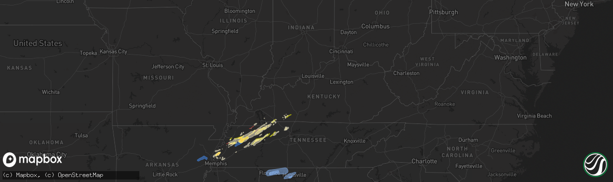
Hail Map in Kentucky on February 15, 2025
The weather event in Kentucky on February 15, 2025 includes Wind, Tornado, and Hail maps. 12 states and 394 cities were impacted and suffered possible damage. The total estimated number of properties impacted is 2,606.
Want more than just the map?
Turn this storm into a full workflow.
- Owner + property data so you know who to knock
- OnDemand branded weather history reports to win the "did we even have hail?" argument
- RoofTrace estimate so reps stop guessing numbers at the door
Bought this map? Upgrade within 7 days and we'll credit the $230. (10-15 min setup call)
Wind
Tornado
Hail
2,606
Estimated number of impacted properties by a 1.00" hail or larger0
Estimated number of impacted properties by a 1.75" hail or larger0
Estimated number of impacted properties by a 2.50" hail or largerStorm reports in Kentucky
Kentucky
| Date | Description |
|---|---|
| 02/15/20251:20 AM CST | Trees and powerlines were downed with a strong line of thunderstorms near the intersection of 8th st. And hillside dr in corbin. Time is estimated by radar. |
| 02/15/20251:20 AM CST | Trees and power lines were downed at the intersection of 5th street and scuffletown road. Time was estimated based on radar. |
| 02/15/202512:00 AM CST | Power lines down at the end of dreyfus rd going onto clark rd and knob lick in estill county. Time estimated by radar. |
| 02/14/202511:01 PM CST | Barn lost a third of its roof on whitlow road near les williams rd. Time based on radar. |
| 02/14/20259:57 PM CST | Delayed report. One power pole was damaged... A few cedar trees lost limbs... A restaurant sign was damaged... And an electrical riser was torn off of a home by a damag |
| 02/14/20259:52 PM CST | Partial collapse of a large barn. Time based on radar. |
| 02/14/20259:46 PM CST | The national weather service in louisville confirmed an ef1 tornado in western simpson county during the late evening hours on february 15th. The tornado was on the gro |
| 02/14/20259:40 PM CST | Quarter-sized hail was reported near auburn. |
All States Impacted by Hail Map on February 15, 2025
Cities Impacted by Hail Map on February 15, 2025
- Wynne, AR
- Cherry Valley, AR
- Parkin, AR
- Earle, AR
- Pelican, LA
- Ripley, TN
- Halls, TN
- Drummonds, TN
- Burlison, TN
- Millington, TN
- Gates, TN
- Friendship, TN
- Alamo, TN
- Trenton, TN
- Humboldt, TN
- Dyersburg, TN
- Monticello, AR
- Newbern, TN
- Dyer, TN
- Rutherford, TN
- Bradford, TN
- Cottage Grove, TN
- Brighton, TN
- Osceola, AR
- Wilson, AR
- Henning, TN
- Turrell, AR
- Sharon, TN
- Arlington, TN
- Greenfield, TN
- Kenton, TN
- Puryear, TN
- Brownsville, TN
- Gleason, TN
- McKenzie, TN
- Lake Village, AR
- Greenville, MS
- Leland, MS
- Shaw, MS
- Boyle, MS
- Benoit, MS
- Henry, TN
- Paris, TN
- Atwood, TN
- Milan, TN
- Trezevant, TN
- Murray, KY
- Hazel, KY
- Springville, TN
- Buchanan, TN
- Mansfield, TN
- Big Sandy, TN
- Medina, TN
- Jackson, TN
- Hollow Rock, TN
- Stewart, TN
- Dover, TN
- Camden, TN
- Selmer, TN
- Lexington, TN
- Bethel Springs, TN
- Buena Vista, TN
- Adamsville, TN
- Finger, TN
- Bruceton, TN
- Enville, TN
- Westport, TN
- Reagan, TN
- Bells, TN
- Gadsden, TN
- Huntingdon, TN
- Cedar Grove, TN
- Yuma, TN
- Holladay, TN
- Fort Campbell, KY
- Big Rock, TN
- Indian Mound, TN
- Wildersville, TN
- Woodlawn, TN
- Tennessee Ridge, TN
- Cumberland City, TN
- Pembroke, KY
- Hopkinsville, KY
- Clarksville, TN
- Oak Grove, KY
- New Johnsonville, TN
- Waverly, TN
- Eva, TN
- Lavinia, TN
- Oakfield, TN
- Russellville, KY
- Lewisburg, KY
- Olmstead, KY
- Allensville, KY
- McEwen, TN
- Vanleer, TN
- Dickson, TN
- Charlotte, TN
- Cumberland Furnace, TN
- Erin, TN
- Joelton, TN
- Springfield, TN
- Greenbrier, TN
- Ashland City, TN
- Pleasant View, TN
- Crystal Springs, MS
- Byram, MS
- Utica, MS
- Terry, MS
- Raymond, MS
- Goodlettsville, TN
- Pittsboro, NC
- Pittsboro, MS
- Calhoun City, MS
- Vardaman, MS
- Houston, MS
- Randolph, MS
- Houlka, MS
- Cadiz, KY
- Bumpus Mills, TN
- Pontotoc, MS
- Belden, MS
- Okolona, MS
- Shannon, MS
- Tupelo, MS
- Nettleton, MS
- Plantersville, MS
- Fulton, MS
- Pelahatchie, MS
- Morton, MS
- Philadelphia, MS
- Conehatta, MS
- Walnut Grove, MS
- Union, MS
- Sebastopol, MS
- Forest, MS
- Cleveland, MS
- Smithville, MS
- Amory, MS
- Tremont, MS
- Hamilton, AL
- Lyford, TX
- Decatur, AL
- Tanner, AL
- Madison, AL
- Huntsville, AL
- Harvest, AL
- Athens, AL
- Carrollton, AL
- Ethelsville, AL
- Millport, AL
- Reform, AL
- Sulligent, AL
- Vernon, AL
- Winfield, AL
- Kennedy, AL
- Fayette, AL
- Gordo, AL
- Coker, AL
- Northport, AL
- Echola, AL
- Elrod, AL
- Bankston, AL
- Tuscaloosa, AL
- Buhl, AL
- Berry, AL
- Cottondale, AL
- Brookwood, AL
- Fosters, AL
- Ralph, AL
- Eutaw, AL
- Aliceville, AL
- Knoxville, AL
- Adger, AL
- Carbon Hill, AL
- Blacksburg, SC
- Easley, SC
- Riverside, AL
- Lincoln, AL
- Six Mile, SC
- Stanley, NC
- Wake Forest, NC
- Dawsonville, GA
- Cleveland, GA
- Pell City, AL
- Carrboro, NC
- Cowpens, SC
- Ball Ground, GA
- Chesnee, SC
- Dallas, NC
- Cedartown, GA
- Mayo, SC
- Cornelia, GA
- Conway, NC
- Canton, GA
- Boiling Springs, SC
- Richfield, NC
- Ohatchee, AL
- Staley, NC
- Suffolk, VA
- Gainesville, GA
- Enfield, NC
- Aragon, GA
- Taylorsville, GA
- Greer, SC
- Ramseur, NC
- Leeds, AL
- Warrenton, NC
- Hollister, NC
- Louisburg, NC
- Halifax, NC
- Clermont, GA
- Snow Camp, NC
- Demorest, GA
- Anniston, AL
- Virginia Beach, VA
- Rockwell, NC
- Chapel Hill, NC
- Salisbury, NC
- Chesapeake, VA
- Bessemer, AL
- Lula, GA
- Gold Hill, NC
- Acworth, GA
- Littleton, NC
- Toccoa, GA
- Jacksonville, AL
- Siler City, NC
- Seneca, SC
- Cumming, GA
- Bessemer City, NC
- Grover, NC
- Weaver, AL
- McCalla, AL
- Cartersville, GA
- Mount Airy, GA
- Creedmoor, NC
- Graham, NC
- Taylors, SC
- Denton, NC
- Murrayville, GA
- Murfreesboro, NC
- Alexandria, AL
- Liberty, SC
- Central, SC
- Piedmont, AL
- Duncanville, AL
- Kannapolis, NC
- Vance, AL
- Gaffney, SC
- Durham, NC
- Fruithurst, AL
- Como, NC
- Gastonia, NC
- Asheboro, NC
- Youngsville, NC
- Westminster, SC
- Wellford, SC
- Greenville, SC
- Rockmart, GA
- Shelby, NC
- Mount Holly, NC
- Huntersville, NC
- Franklinton, NC
- Emerson, GA
- Jackson, NC
- Lyman, SC
- Gates, NC
- Inman, SC
- Walhalla, SC
- Birmingham, AL
- Concord, NC
- Pendleton, NC
- Franklinville, NC
- Kings Mountain, NC
- San Perlita, TX
- Bruce, MS
- Big Creek, MS
- Sylacauga, AL
- Weogufka, AL
- Selma, AL
- Sardis, AL
- Orrville, AL
- Lowndesboro, AL
- Tyler, AL
- Jones, AL
- Marbury, AL
- Verbena, AL
- Deatsville, AL
- Billingsley, AL
- Autaugaville, AL
- Prattville, AL
- Booth, AL
- Rockford, AL
- Titus, AL
- Elmore, AL
- Coosada, AL
- Millbrook, AL
- Wetumpka, AL
- Equality, AL
- Eclectic, AL
- Montgomery, AL
- Hayneville, AL
- Dadeville, AL
- Shorter, AL
- Tuskegee, AL
- Purvis, MS
- Hattiesburg, MS
- Petal, MS
- Richton, MS
- New Augusta, MS
- Beaumont, MS
- Oakman, AL
- Woodstock, AL
- West Blocton, AL
- Eldridge, AL
- Brierfield, AL
- Helena, AL
- Alabaster, AL
- Montevallo, AL
- Austell, GA
- Mableton, GA
- Atlanta, GA
- Lithia Springs, GA
- Evergreen, AL
- Red Level, AL
- Andalusia, AL
- McKenzie, AL
- Opp, AL
- Jackson, GA
- Monticello, GA
- Covington, GA
- Mansfield, GA
- Shady Dale, GA
- De Soto, GA
- Cobb, GA
- Leslie, GA
- Cordele, GA
- Vienna, GA
- Pitts, GA
- Ponce De Leon, FL
- Inlet Beach, FL
- Vernon, FL
- Ebro, FL
- Panama City Beach, FL
- Panama City, FL
- Lynn Haven, FL
- Collinsville, MS
- Meridian, MS
- Bailey, MS
- Lauderdale, MS
- Daleville, MS
- De Kalb, MS
- Toomsuba, MS
- Porterville, MS
- Cuba, AL
- York, AL
- Livingston, AL
- Boligee, AL
- Auburn, KY
- Sheffield, AL
- Florence, AL
- Tuscumbia, AL
- Muscle Shoals, AL
- Killen, AL
- Leighton, AL
- Town Creek, AL
- Rogersville, AL
- Courtland, AL
- Lexington, AL
- Hillsboro, AL
- Lester, AL
- Elkmont, AL
- Anderson, AL
- Gallion, AL
- Greensboro, AL
- Newbern, AL
- Marion, AL
- Forkland, AL
- Uniontown, AL
- Clanton, AL
- Jemison, AL
- Shelby, AL
- Goodwater, AL
- Ashland, AL
- Talladega, AL
- Alpine, AL
- Millerville, AL
- Alexander City, AL
- Cragford, AL
- Daviston, AL
- Wadley, AL
- Lineville, AL
- Wedowee, AL


