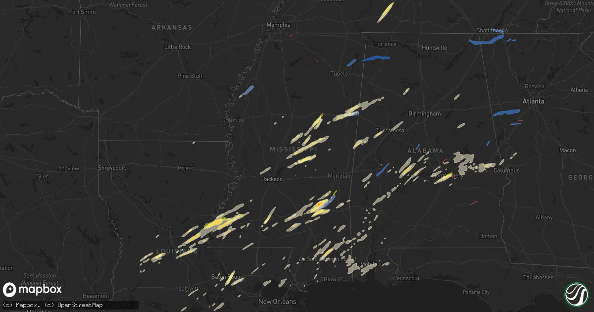
Hail Map in Mississippi on January 3, 2023
Get this storm
January 3 map
$229
one time, instant access
Download today. No call, no setup
Keep the $229
Bought the map and want the full workflow? Apply the entire $229 to a subscription within 7 days. None of it is wasted.
Every map, not just this one
This buys you this map. Subscription and you get every map we run, in the markets you choose from a few cities to whole states to nationwide. Plus real-time alerts the moment a storm fires.
Contact data
Name, contact info, occupancy, even credit band for addresses in the footprint. You go from where it hit to who to call.
Become the source they trust
Unlimited branding weather history reports on demand. You already have the documented answer ready for the property owner, and you are the one who showed up with it.
Property data and RoofTrace estimates
Pull up any address you have got, its value and the exact code rules for that jurisdiction, straight from One Click Code. Then RoofTrace estimates the squares, pitch, and roof value, priced the way you price.
Storm reports in Mississippi
Mississippi
| Date | Description |
|---|---|
| 01/03/20235:45 PM CST | Wind damage reported to transformer at substation. |
| 01/03/20235:22 PM CST | Tree fell on vehicle at intersection of monroe rd and moselle seminary rd. |
| 01/03/20235:06 PM CST | Reported near natchez. |
| 01/03/20235:06 PM CST | A local report indicates 1.00 inch wind near 1 S NATCHEZ |
| 01/03/20235:03 PM CST | Report via social media. |
| 01/03/20234:15 PM CST | Quarter size hail reported about 10 miles ne of natchez in jefferson co. |
| 01/03/202310:32 AM CST | Pictures on social media show a tree that knocked down power lines on highway 9. |
| 01/03/202310:26 AM CST | Multiple structures damaged and trees down in golden. Time is radar estimated. |
| 01/03/202310:08 AM CST | Tree fallen on one house and shingle damage to another house on dickerson rd. |
| 01/03/202310:06 AM CST | Roof damage to home off ramey rd. |
| 01/03/202310:06 AM CST | Numerous powerlines... Trees and single damage to homes in the houston community center area. |
| 01/03/20239:38 AM CST | Multiple trees down at whispering pines golf course. Time is radar estimated. |
| 01/03/20239:07 AM CST | Trees down across road which took the powerline out. |
| 01/03/20239:07 AM CST | A tornado touched down near highway 30 in union county and moved to the east-southeast along the highway. Damage team rated the tornado an ef1. |
| 01/03/20239:04 AM CST | Minor damage to a couple of homes and tree damage. |
| 01/03/20236:49 AM CST | A traffic light was damaged at ms hwy 8 and chrisman ave. |
| 01/03/20236:38 AM CST | Measured at a private farm weather station. |
| 01/03/20236:07 AM CST | Numerous stockade fences damaged or blown over in the braybourne subdivision just west of goodman road and cedar hill road. |
| 01/03/20236:04 AM CST | Corrects previous tornado report from 2 ese olive branch. A tornado debris signature was detected east of olive branch. |
| 01/03/20235:27 AM CST | At 1126 PM CST, a severe thunderstorm was located 4 miles east of Richton, moving northeast at 35 mph. HAZARD...60 mph wind gusts. SOURCE...Radar indicated. IMPACT...Expect damage to roofs, siding, and trees. Locations impacted include... Richton, State Line and Buckatunna. |
| 01/03/20234:44 AM CST | At 1044 PM CST, a severe thunderstorm was located over Steens, or near Columbus, moving northeast at 45 mph. HAZARD...60 mph wind gusts and quarter size hail. SOURCE...Radar indicated. IMPACT...Hail damage to vehicles is expected. Expect wind damage to roofs, siding, and trees. Locations impacted include... Vernon, Millport, Kennedy, Blooming Grove, Crossville, Cody, Star, Hightogy, Forest, Melborne and Shaw. |
| 01/03/20234:44 AM CST | At 1043 PM CST, a severe thunderstorm was located over Moss, or near Laurel, moving northeast at 40 mph. HAZARD...Ping pong ball size hail and 60 mph wind gusts. SOURCE...Radar indicated. IMPACT...People and animals outdoors will be injured. Expect hail damage to roofs, siding, windows, and vehicles. Expect wind damage to roofs, siding, and trees. This severe thunderstorm will be near... Sandersville around 1050 PM CST. Heidelberg around 1100 PM CST. Stafford Springs around 1105 PM CST. Goodwater and Barnett around 1110 PM CST.Other locations impacted by this severe thunderstorm include Pachutaand Shubuta. |
| 01/03/20234:39 AM CST | At 1039 AM CST, a severe thunderstorm was located near Sherwood, or 20 miles southwest of Montpelier, moving northeast at 50 mph. HAZARD...60 mph wind gusts. SOURCE...Radar indicated. IMPACT...Expect damage to roofs, siding, and trees. This severe thunderstorm will be near... Mathiston around 1045 AM CST. Maben, Cumberland and Clarkson around 1050 AM CST. Pheba around 1100 AM CST. Montpelier and Griffith around 1105 AM CST. Pala Alto around 1110 AM CST.Other locations impacted by this severe thunderstorm include Manteeand Walthall. |
| 01/03/20234:23 AM CST | At 1022 PM CST, a severe thunderstorm was located near Bethsaida, or 7 miles east of Philadelphia, moving northeast at 60 mph. HAZARD...60 mph wind gusts. SOURCE...Radar indicated. IMPACT...Expect damage to roofs, siding, and trees. This severe thunderstorm will be near... Nanih Waiya and Bluff Springs around 1035 PM CST. Preston around 1040 PM CST. Gholson around 1045 PM CST. Mashulaville around 1050 PM CST.Other locations impacted by this severe thunderstorm includeShuqualak and Tucker. |
| 01/03/20234:14 AM CST | At 1013 AM CST, severe thunderstorms were located along a line extending from near Midway to 6 miles south of Burton to near Fairview, moving east at 45 mph. HAZARD...60 mph wind gusts. SOURCE...Radar indicated. IMPACT...Expect damage to roofs, siding, and trees. Locations impacted include... Florence, Muscle Shoals, Russellville, Sheffield, Tuscumbia, Red Bay, Phil Campbell, Killen, Cherokee and Littleville. |
| 01/03/20234:04 AM CST | At 1004 PM CST, a severe thunderstorm was located over Taylorsville, or 9 miles west of Stringer, moving northeast at 40 mph. HAZARD...60 mph wind gusts and quarter size hail. SOURCE...Radar indicated. IMPACT...Hail damage to vehicles is expected. Expect wind damage to roofs, siding, and trees. This severe thunderstorm will be near... Stringer around 1015 PM CST. Bay Springs and Vernon around 1025 PM CST. Turnerville around 1035 PM CST.Other locations impacted by this severe thunderstorm includeSylvarena and Louin. |
| 01/03/20234:02 AM CST | At 1002 PM CST, a severe thunderstorm was located 7 miles northwest of Stallo, or 12 miles southwest of Louisville, moving northeast at 55 mph. HAZARD...60 mph wind gusts and half dollar size hail. SOURCE...Radar indicated. IMPACT...Hail damage to vehicles is expected. Expect wind damage to roofs, siding, and trees. This severe thunderstorm will be near... Louisville around 1015 PM CST. Millcreek around 1020 PM CST. Betheden around 1025 PM CST. Oktoc around 1040 PM CST.Other locations impacted by this severe thunderstorm includeNoxapater. |
| 01/03/20233:59 AM CST | At 959 AM CST, severe thunderstorms were located along a line extending from near Pratts Friendship to near Tombigbee State Park to near Okolona, moving east at 45 mph. HAZARD...60 mph wind gusts. SOURCE...Radar indicated. IMPACT...Expect damage to roofs, siding, and trees. Locations impacted include... Tupelo, Amory, Fulton, Verona, Okolona, Tombigbee State Park, Belmont, Shannon, Plantersville, Mantachie, Smithville, Tremont, Fairview, New Salem, Pratts Friendship, Sandy Springs, Evergreen, Clay, Nettleton and Marietta. |
| 01/03/20233:47 AM CST | At 946 PM CST, a severe thunderstorm was located near Collins, moving east at 40 mph. HAZARD...60 mph wind gusts and half dollar size hail. SOURCE...Radar indicated. IMPACT...Hail damage to vehicles is expected. Expect wind damage to roofs, siding, and trees. This severe thunderstorm will be near... Hebron around 955 PM CST. Laurel around 1010 PM CST. Moss around 1015 PM CST. Sandersville around 1030 PM CST. Mill Creek around 1035 PM CST.Other locations impacted by this severe thunderstorm include Soso. |
| 01/03/20233:42 AM CST | At 942 AM CST, a severe thunderstorm was located near Winona, moving northeast at 60 mph. HAZARD...60 mph wind gusts. SOURCE...Radar indicated. IMPACT...Expect damage to roofs, siding, and trees. This severe thunderstorm will be near... Sweatman and Lodi around 955 AM CST. Misterton around 1000 AM CST. Embry around 1005 AM CST.Other locations impacted by this severe thunderstorm include Manteeand Walthall. |
| 01/03/20233:37 AM CST | At 937 AM CST, severe thunderstorms were located along a line extending from 6 miles northwest of Hinkle to near Jumpertown to near New Harmony, moving east at 45 mph. HAZARD...60 mph wind gusts. SOURCE...Radar indicated. IMPACT...Expect damage to roofs, siding, and trees. Locations impacted include... Corinth, Booneville, Baldwyn, Iuka, J P Coleman State Park, Tishomingo State Park, Guntown, Belmont, Burnsville, Jumpertown, Glen, Tishomingo, Thrashers, Midway, Walnut Grove, Pineflat, Hinkle, Burton, Wheeler and Leedy. |
| 01/03/20233:36 AM CST | At 936 AM CST, a severe thunderstorm was located near Gallman, or near Hazlehurst, moving northeast at 45 mph. HAZARD...60 mph wind gusts and quarter size hail. SOURCE...Radar indicated. IMPACT...Hail damage to vehicles is expected. Expect wind damage to roofs, siding, and trees. This severe thunderstorm will be near... Gallman around 940 AM CST. Crystal Springs around 945 AM CST. Terry and Hopewell around 955 AM CST. Whites around 1000 AM CST. Florence and Harrisville around 1005 AM CST. Star and Monterey around 1010 AM CST. Piney Woods around 1015 AM CST. Cato around 1020 AM CST.Other locations impacted by this severe thunderstorm include D'Lo,Braxton, Puckett and Georgetown. |
| 01/03/20233:28 AM CST | At 927 AM CST, severe thunderstorms were located along a line extending from near New Harmony to near Houlka to near Sabougla, moving east at 45 mph. HAZARD...60 mph wind gusts. SOURCE...Radar indicated. IMPACT...Expect damage to roofs, siding, and trees. Locations impacted include... Tupelo, Pontotoc, Houston, Baldwyn, Verona, Okolona, Trace State Park, Tombigbee State Park, Saltillo, Guntown, Calhoun City, Shannon, Vardaman, Plantersville, Derma, Pittsboro, Slate Springs, Sabougla, New Harmony and Pratts Friendship. |
| 01/03/20233:27 AM CST | At 927 PM CST, a severe thunderstorm was located near Thomastown, or 7 miles west of Carthage, moving northeast at 40 mph. HAZARD...Ping pong ball size hail and 60 mph wind gusts. SOURCE...Radar indicated. IMPACT...People and animals outdoors will be injured. Expect hail damage to roofs, siding, windows, and vehicles. Expect wind damage to roofs, siding, and trees. This severe thunderstorm will be near... Thomastown around 930 PM CST. Carthage around 935 PM CST. Singleton around 945 PM CST. Renfroe around 950 PM CST. Edinburg around 955 PM CST. Zama around 1000 PM CST.Other locations impacted by this severe thunderstorm includeRedwater. |
| 01/03/20233:17 AM CST | At 917 AM CST, a severe thunderstorm was located over Black Hawk, moving northeast at 45 mph. HAZARD...60 mph wind gusts and quarter size hail. SOURCE...Radar indicated. IMPACT...Hail damage to vehicles is expected. Expect wind damage to roofs, siding, and trees. This severe thunderstorm will be near... Coila around 925 AM CST. North Carrollton around 935 AM CST. Winona around 945 AM CST. Duck Hill around 955 AM CST.Other locations impacted by this severe thunderstorm includeCarrollton. |
| 01/03/20233:07 AM CST | At 906 PM CST, a severe thunderstorm was located over Progress, or 20 miles north of Columbia, moving northeast at 50 mph. HAZARD...60 mph wind gusts and quarter size hail. SOURCE...Radar indicated. IMPACT...Hail damage to vehicles is expected. Expect wind damage to roofs, siding, and trees. This severe thunderstorm will be near... Prentiss and Carson around 915 PM CST. Lone Star around 925 PM CST. Mount Olive around 930 PM CST. Collins around 935 PM CST.Other locations impacted by this severe thunderstorm includeBassfield and Seminary. |
| 01/03/20233:01 AM CST | At 901 AM CST, severe thunderstorms were located along a line extending from 8 miles west of Blue Mountain to near Etta to 6 miles east of Denmark, moving northeast at 45 mph. HAZARD...60 mph wind gusts. SOURCE...Radar indicated. IMPACT...Expect damage to roofs, siding, and trees. Locations impacted include... New Albany, Ripley, Blue Mountain, Jumpertown, Keownville, Theo, Etta, Gravestown, Pinedale, Thaxton, Hickory Flat, Falkner, Myrtle, Dumas, Shari, Murry, Graham, Esperanza, Pumpkin Center and Bethel. |
| 01/03/20232:52 AM CST | At 852 AM CST, a severe thunderstorm was located over Red Lick, or 30 miles northeast of Natchez, moving northeast at 55 mph. HAZARD...60 mph wind gusts and quarter size hail. SOURCE...Radar indicated. IMPACT...Hail damage to vehicles is expected. Expect wind damage to roofs, siding, and trees. This severe thunderstorm will be near... Pattison and Mcbride around 900 AM CST. Peyton and Hermanville around 905 AM CST. Barlow around 910 AM CST. Dentville and Carpenter around 920 AM CST. |
| 01/03/20232:43 AM CST | At 843 PM CST, a severe thunderstorm was located over Garden City, or 21 miles northwest of Liberty, moving northeast at 50 mph. HAZARD...60 mph wind gusts and half dollar size hail. SOURCE...Radar indicated. IMPACT...Hail damage to vehicles is expected. Expect wind damage to roofs, siding, and trees. This severe thunderstorm will be near... Bude around 900 PM CST. New Hope around 905 PM CST. Little Springs around 910 PM CST. Mccall Creek around 915 PM CST. West Lincoln around 920 PM CST. Vaughn and Loyd Star around 925 PM CST.Other locations impacted by this severe thunderstorm includeMeadville. |
| 01/03/20232:40 AM CST | At 839 AM CST, severe thunderstorms were located along a line extending from near Paris to near Coffeeville, moving east at 45 mph. HAZARD...60 mph wind gusts. SOURCE...Radar indicated. IMPACT...Expect damage to roofs, siding, and trees. Locations impacted include... Pontotoc, Houston, Trace State Park, Bruce, Calhoun City, Vardaman, Derma, Coffeeville, Ecru, Pittsboro, Slate Springs, Sabougla, New Harmony, Randolph, Pyland, Banner, Tula, Houlka, Paris and Sherman. |
| 01/03/20232:37 AM CST | At 836 PM CST, a severe thunderstorm was located near Mcadams, or near Kosciusko, moving northeast at 35 mph. HAZARD...60 mph wind gusts and half dollar size hail. SOURCE...Radar indicated. IMPACT...Hail damage to vehicles is expected. Expect wind damage to roofs, siding, and trees. This severe thunderstorm will be near... Kosciusko and Hesterville around 840 PM CST. Chester around 930 PM CST.Other locations impacted by this severe thunderstorm include Mccool,Ethel, French Camp and Weir. |
| 01/03/20232:36 AM CST | At 836 PM CST, a severe thunderstorm was located over Enterprise, or 9 miles southeast of Brookhaven, moving northeast at 50 mph. HAZARD...60 mph wind gusts and quarter size hail. SOURCE...Radar indicated. IMPACT...Hail damage to vehicles is expected. Expect wind damage to roofs, siding, and trees. This severe thunderstorm will be near... East Lincoln around 840 PM CST. Monticello and Sontag around 855 PM CST. Wanilla around 900 PM CST. Oma around 905 PM CST. Shivers around 915 PM CST. Pinola around 920 PM CST.Other locations impacted by this severe thunderstorm include NewHebron and Silver Creek. |
| 01/03/20232:22 AM CST | At 822 AM CST, a severe thunderstorm was located over Holly Springs National Forest, moving northeast at 55 mph. HAZARD...60 mph wind gusts. SOURCE...Radar indicated. IMPACT...Expect damage to roofs, siding, and trees. Locations impacted include... Oxford, New Albany, Ripley, Holly Springs National Forest, Blue Mountain, Cambridge, Keownville, Bethlehem, Etta, Burgess, Denmark, Pinedale, Thaxton, Hickory Flat, Myrtle, Dumas, Abbeville, Taylor, Shari and Keel. |
| 01/03/20231:56 AM CST | At 755 AM CST, a severe thunderstorm was located near Paynes, or 11 miles southwest of Charleston, moving northeast at 55 mph. HAZARD...60 mph wind gusts. SOURCE...Radar indicated. IMPACT...Expect damage to roofs, siding, and trees. Locations impacted include... Oxford, Water Valley, Charleston, George Payne State Park, Holly Springs National Forest, Coffeeville, Webb, Sumner, Pope, Enid, Paynes, Springdale, Burgess, Banner, Velma, Scobey, Paris, Oakland, Courtland and Taylor. |
| 01/03/20231:48 AM CST | At 748 AM CST, severe thunderstorms were located along a line extending from near Grace to near Fitler, moving northeast at 60 mph. HAZARD...60 mph wind gusts. SOURCE...Radar indicated. IMPACT...Expect damage to roofs, siding, and trees. Severe thunderstorms will be near... Rolling Fork, Anguilla, Nitta Yuma and Panther Burn around 755 AM CST. Delta City around 800 AM CST.Other locations impacted by these severe thunderstorms include Cary. |
| 01/03/20231:46 AM CST | At 745 PM CST, a severe thunderstorm was located near Cranfield, or 14 miles east of Natchez, moving northeast at 55 mph. HAZARD...60 mph wind gusts and half dollar size hail. SOURCE...Radar indicated. IMPACT...Hail damage to vehicles is expected. Expect wind damage to roofs, siding, and trees. This severe thunderstorm will be near... Hamburg, Mcnair, Kirby and Stampley around 755 PM CST. New Hope around 805 PM CST. Blue Hill around 810 PM CST. Pleasant Hill, Union Church and Mcbride around 815 PM CST. Allen and Caseyville around 820 PM CST. Barlow around 825 PM CST. Glancy and Martinsville around 835 PM CST.Other locations impacted by this severe thunderstorm include Roxieand Beauregard. |
| 01/03/20231:33 AM CST | At 731 PM CST, a severe thunderstorm was located over Tuckers Crossing, or 6 miles east of Ellisville, moving east at 35 mph. HAZARD...Ping pong ball size hail and 60 mph wind gusts. SOURCE...Radar indicated. IMPACT...People and animals outdoors will be injured. Expect hail damage to roofs, siding, windows, and vehicles. Expect wind damage to roofs, siding, and trees. Locations impacted include... Waynesboro. |
| 01/03/20231:33 AM CST | At 733 AM CST, a severe thunderstorm was located over Monterey, moving northeast at 50 mph. HAZARD...60 mph wind gusts and quarter size hail. SOURCE...Radar indicated. IMPACT...Hail damage to vehicles is expected. Expect wind damage to roofs, siding, and trees. This severe thunderstorm will be near... Frogmore around 745 AM CST. Ferriday and West Ferriday around 750 AM CST. Vidalia around 755 AM CST. Natchez and Spokane around 800 AM CST. Stanton around 810 AM CST.Other locations impacted by this severe thunderstorm includeRidgecrest. |
| 01/03/20231:23 AM CST | At 720 AM CST, a severe thunderstorm was located near Crowder, or 15 miles northwest of Charleston, moving northeast at 55 mph. HAZARD...60 mph wind gusts. SOURCE...Radar indicated. IMPACT...Expect damage to roofs, siding, and trees. Locations impacted include... Oxford, Batesville, Holly Springs National Forest, John W Kyle State Park, Marks, Sardis, Lambert, Crowder, Pope, Cambridge, Harmontown, Curtis Station, Burgess, Laws Hill, Courtland, Abbeville, Malone, Mims, Asa and Glenville. |
| 01/03/20231:18 AM CST | At 717 PM CST, a severe thunderstorm was located near Slocum, or 13 miles southeast of Monterey, moving northeast at 30 mph. HAZARD...60 mph wind gusts and quarter size hail. SOURCE...Radar indicated. IMPACT...Hail damage to vehicles is expected. Expect wind damage to roofs, siding, and trees. This severe thunderstorm will be near... Sibley around 735 PM CST. Kingston around 750 PM CST. Cranfield and Stanton around 810 PM CST. |
| 01/03/20231:07 AM CST | At 707 PM CST, a severe thunderstorm was located near Ackerman, or 18 miles north of Louisville, moving northeast at 50 mph. HAZARD...60 mph wind gusts and quarter size hail. SOURCE...Radar indicated. IMPACT...Hail damage to vehicles is expected. Expect wind damage to roofs, siding, and trees. This severe thunderstorm will be near... Sherwood around 715 PM CST. Pheba around 730 PM CST. Griffith around 740 PM CST. Pala Alto around 745 PM CST. West Point around 750 PM CST.Other locations impacted by this severe thunderstorm include Sturgis. |
| 01/03/202312:45 AM CST | At 645 AM CST, a severe thunderstorm was located 7 miles east of Shelby, moving northeast at 60 mph. HAZARD...70 mph wind gusts. SOURCE...Public. IMPACT...Expect considerable tree damage. Damage is likely to mobile homes, roofs, and outbuildings. Locations impacted include... Clarksdale, Tutwiler, Marks, Lambert, Crowder, Belen, Dublin, Vance, Darling, Mattson, Counts, Mims, Barksdale, Denton, Sabino, Lurand, Beaver Dam, Essex, West Marks and Hopson. |
| 01/03/202312:42 AM CST | At 642 AM CST, a severe thunderstorm was located near Mound Bayou, or 8 miles northwest of Drew, moving northeast at 60 mph. HAZARD...70 mph wind gusts. SOURCE...Radar indicated. IMPACT...Expect considerable tree damage. Damage is likely to mobile homes, roofs, and outbuildings. This severe thunderstorm will be near... Parchman and Rome around 655 AM CST. |
| 01/03/202312:17 AM CST | At 617 PM CST, a severe thunderstorm was located near Zama, or 10 miles east of Kosciusko, moving northeast at 40 mph. HAZARD...60 mph wind gusts and half dollar size hail. SOURCE...Radar indicated. IMPACT...Hail damage to vehicles is expected. Expect wind damage to roofs, siding, and trees. This severe thunderstorm will be near... Ackerman and Chester around 655 PM CST.Other locations impacted by this severe thunderstorm include Mccool,Weir and Ethel. |
| 01/03/202312:14 AM CST | At 614 PM CST, a severe thunderstorm was located near Lake Ophelia National Wildlife Refuge, or 9 miles north of Bordelonville, moving northeast at 30 mph. HAZARD...60 mph wind gusts and quarter size hail. SOURCE...Radar indicated. IMPACT...Hail damage to vehicles is expected. Expect wind damage to roofs, siding, and trees. This severe thunderstorm will be near... Acme around 620 PM CST. Slocum around 640 PM CST. Deer Park around 655 PM CST. |
| 01/03/202312:02 AM CST | At 601 PM CST, a severe thunderstorm was located 4 miles south of Tuckers Crossing, or 7 miles east of Ellisville, moving northeast at 35 mph. HAZARD...60 mph wind gusts and quarter size hail. SOURCE...Radar indicated. IMPACT...Hail damage to vehicles is expected. Expect wind damage to roofs, siding, and trees. Locations impacted include... Waynesboro and Clara. |
| 01/03/202312:01 AM CST | At 601 PM CST, a severe thunderstorm was located near Ludlow, or 10 miles southwest of Carthage, moving northeast at 45 mph. HAZARD...60 mph wind gusts and quarter size hail. SOURCE...Radar indicated. IMPACT...Hail damage to vehicles is expected. Expect wind damage to roofs, siding, and trees. This severe thunderstorm will be near... Tuscola around 610 PM CST. Carthage around 615 PM CST. Madden around 625 PM CST. Edinburg around 630 PM CST. Philadelphia and Pearl River around 635 PM CST. Burnside around 645 PM CST. Stallo around 650 PM CST. Nanih Waiya around 700 PM CST.Other locations impacted by this severe thunderstorm include Lena,Standing Pine and Walnut Grove. |
| 01/02/202311:48 PM CST | At 548 PM CST, a severe thunderstorm was located over Pearl, moving northeast at 25 mph. HAZARD...60 mph wind gusts and quarter size hail. SOURCE...Radar indicated. IMPACT...Hail damage to vehicles is expected. Expect wind damage to roofs, siding, and trees. This severe thunderstorm will be near... Brandon around 600 PM CST. Pelahatchie around 630 PM CST. Leesburg around 645 PM CST. |
| 01/02/202311:25 PM CST | At 524 PM CST, a severe thunderstorm was located near Moselle, or 9 miles northwest of Petal, moving northeast at 30 mph. HAZARD...60 mph wind gusts and nickel size hail. SOURCE...Radar indicated. IMPACT...Expect damage to roofs, siding, and trees. This severe thunderstorm will be near... Moselle around 530 PM CST. Laurel and Ellisville around 545 PM CST. Ovett around 555 PM CST. Tuckers Crossing around 600 PM CST. Mill Creek around 615 PM CST. |
| 01/02/202311:20 PM CST | Reported in the elwood community... Report via social media. |
| 01/02/202311:20 PM CST | Trees and power lines downed near the harmony community. |
| 01/02/202311:04 PM CST | Larger than quarter size hail reported outside of heidelberg. Report via social media. |
| 01/02/202310:46 PM CST | Power lines downed along ms hwy 50 near tabernacle rd. |
| 01/02/202310:45 PM CST | Several roofs in the moss community were damaged and leaking due to large hail. Exact hail size was not provided. |
| 01/02/202310:45 PM CST | Quarter size hail near shady grove. Report via social media. |
| 01/02/202310:43 PM CST | Nickel to quarter size hail south of columbus afb. Report via social media. |
| 01/02/202310:42 PM CST | At 442 PM CST, a severe thunderstorm was located over Deer Park, or 8 miles east of Monterey, moving northeast at 40 mph. HAZARD...60 mph wind gusts and quarter size hail. SOURCE...Radar indicated. IMPACT...Hail damage to vehicles is expected. Expect wind damage to roofs, siding, and trees. This severe thunderstorm will be near... Natchez and Vidalia around 500 PM CST. Cranfield around 515 PM CST. Stanton around 520 PM CST. Stampley and Church Hill around 525 PM CST. |
| 01/02/202310:38 PM CST | At 438 PM CST, a severe thunderstorm was located over Improve, or 11 miles northeast of Columbia, moving northeast at 30 mph. HAZARD...60 mph wind gusts and nickel size hail. SOURCE...Radar indicated. IMPACT...Expect damage to roofs, siding, and trees. This severe thunderstorm will be near... Melba around 445 PM CST. Sumrall around 455 PM CST. Rawls Springs around 510 PM CST. Sanford around 515 PM CST. Eastabuchie around 525 PM CST.Other locations impacted by this severe thunderstorm includeSeminary. |
| 01/02/202310:35 PM CST | Report via social media. |
| 01/02/202310:20 PM CST | Reported between noxapater and center ridge along ms hwy 15. |
| 01/02/20238:51 PM CST | At 250 PM CST, a severe thunderstorm was located over Larto, moving northeast at 35 mph. HAZARD...Golf ball size hail and 60 mph wind gusts. SOURCE...Radar indicated. IMPACT...People and animals outdoors will be injured. Expect hail damage to roofs, siding, windows, and vehicles. Expect wind damage to roofs, siding, and trees. This severe thunderstorm will be near... Larto around 255 PM CST. New Era around 300 PM CST. Mayna around 305 PM CST. Monterey around 320 PM CST. Deer Park and Frogmore around 330 PM CST. Ferriday around 340 PM CST. West Ferriday around 345 PM CST. Natchez around 350 PM CST.Other locations impacted by this severe thunderstorm includeRidgecrest. |
| 01/02/20237:57 PM CST | A local report indicates 1.00 inch wind near 1 WNW ROXIE |
| 01/02/20237:44 PM CST | Hail reported on lower myrick rd near hwy 15 south of laurel. |
| 01/02/20237:38 PM CST | 5 inch tree limbs snapped and trash cans displaced. |
| 01/02/20237:30 PM CST | Report via social media. |
| 01/02/20237:30 PM CST | Corrects previous tstm wnd dmg report from 5 s glade. 5 inch tree limbs snapped and trash cans displaced. |
| 01/02/20237:30 PM CST | Corrects previous tstm wnd dmg r |
| 01/02/20237:11 PM CST | Hail reported north of ackerman. |
| 01/02/20236:15 PM CST | Hail reported just near walnut grove. |
All States Impacted by Hail Map on January 3, 2023
Cities Impacted by Hail Map on January 3, 2023
- Jasper, AL
- Scooba, MS
- Emelle, AL
- Aliceville, AL
- Eutaw, AL
- Ralph, AL
- Knoxville, AL
- Buhl, AL
- Ethel, MS
- Kosciusko, MS
- Carthage, MS
- Bastrop, LA
- Fayette, AL
- Millbrook, AL
- Coosada, AL
- Billingsley, AL
- Plantersville, AL
- Heidelberg, MS
- Shubuta, MS
- Deatsville, AL
- Decatur, MS
- Conehatta, MS
- Hermanville, MS
- Notasulga, AL
- Tallassee, AL
- Tuskegee, AL
- Port Allen, LA
- Brusly, LA
- Soso, MS
- Stringer, MS
- Laurel, MS
- McIntosh, AL
- Tibbie, AL
- State Line, MS
- Richton, MS
- Theriot, LA
- Gibson, LA
- Moreauville, LA
- Monterey, LA
- Marksville, LA
- Perkinston, MS
- Brooklyn, MS
- Beaumont, MS
- Wiggins, MS
- Thomasville, AL
- Pine Hill, AL
- Arlington, AL
- Walnut Grove, MS
- Philadelphia, MS
- Lena, MS
- Waynesboro, MS
- Vidalia, LA
- Woodville, MS
- Natchez, MS
- Farmer City, IL
- Waynesboro, TN
- Lawrenceburg, TN
- Collinwood, TN
- Hohenwald, TN
- Citronelle, AL
- Convent, LA
- Saint James, LA
- Gloster, MS
- Liberty, MS
- Raceland, LA
- Houma, LA
- Bourg, LA
- Dry Creek, LA
- Sugartown, LA
- Little River, AL
- Poplarville, MS
- Carriere, MS
- Bunkie, LA
- Sturgis, MS
- Ackerman, MS
- Mathiston, MS
- Weir, MS
- Cottonport, LA
- Plaucheville, LA
- Evergreen, LA
- Auburn, AL
- Opelika, AL
- Wapella, IL
- Clinton, IL
- Bellflower, IL
- Mansfield, IL
- Saint Stephens, AL
- Millry, AL
- Baton Rouge, LA
- Shiloh, GA
- Hamilton, GA
- Acme, LA
- Hessmer, LA
- Mansura, LA
- Pike Road, AL
- Montgomery, AL
- Vossburg, MS
- Autaugaville, AL
- Prattville, AL
- Caledonia, MS
- Columbus, MS
- Steens, MS
- Slidell, LA
- Oakdale, LA
- Coffeeville, AL
- Boyce, LA
- Elmer, LA
- Sieper, LA
- Otis, LA
- Fayette, MS
- Grant, LA
- Deridder, LA
- Elizabeth, LA
- Pitkin, LA
- Lacombe, LA
- Lafayette, LA
- Collins, MS
- Prairieville, LA
- Denham Springs, LA
- Saint Gabriel, LA
- Addis, LA
- Plaquemine, LA
- Sunshine, LA
- Greenwell Springs, LA
- Weldon, IL
- Maroa, IL
- Dewitt, IL
- Lane, IL
- Gadsden, AL
- Ohatchee, AL
- Ashville, AL
- Bay Springs, MS
- Pennington, AL
- La Place, LA
- Ponchatoula, LA
- Sunflower, AL
- Wagarville, AL
- Jeanerette, LA
- Saint Landry, LA
- Ville Platte, LA
- Simmesport, LA
- Tuscaloosa, AL
- Brookwood, AL
- Cottondale, AL
- Noxapater, MS
- Louisville, MS
- Canton, MS
- Camden, MS
- Uniontown, AL
- Lucedale, MS
- Vinegar Bend, AL
- Leakesville, MS
- Maplesville, AL
- Taylorsville, MS
- Ellisville, MS
- Latham, IL
- Warrensburg, IL
- Cataula, GA
- Wetumpka, AL
- Butler, AL
- Safford, AL
- Morton, MS
- Smiths Station, AL
- Salem, AL
- Fortson, GA
- Gallion, AL
- Sardis, AL
- Jones, AL
- Selma, AL
- Orrville, AL
- Columbia, MS
- Sumrall, MS
- Bassfield, MS
- Mittie, LA
- Morgan City, LA
- Franklin, LA
- Marion Junction, AL
- Marion, AL
- Roxie, MS
- Meadville, MS
- Crosby, MS
- McHenry, MS
- Moselle, MS
- Cruger, MS
- Sidon, MS
- Melvin, AL
- Stapleton, AL
- Coila, MS
- Summit, MS
- Ruth, MS
- Deer Park, AL
- Jackson, AL
- Monticello, MS
- Jayess, MS
- Alexander City, AL
- Eclectic, AL
- Shorter, AL
- Camp Hill, AL
- Dadeville, AL
- Equality, AL
- Reeves, LA
- Rosedale, MS
- McCool, MS
- Tyler, AL
- Hayneville, AL
- Mobile, AL
- Theodore, AL
- Grand Bay, AL
- Moss Point, MS
- Jonesville, LA
- Deville, LA
- Effie, LA
- Center Point, LA
- Pineville, LA
- Pachuta, MS
- Forest, MS
- Bay Saint Louis, MS
- Paulding, MS
- Sallis, MS
- Flora, MS
- Jackson, MS
- Madison, MS
- Clinton, MS
- Bolton, MS
- Brookhaven, MS
- Sontag, MS
- Hazlehurst, MS
- Wesson, MS
- Bogue Chitto, MS
- Starkville, MS
- Ashland, AL
- Talladega, AL
- Lineville, AL
- Millport, AL
- Vernon, AL
- Sulligent, AL
- Artesia, MS
- Kennedy, AL
- West Point, MS
- Lowndesboro, AL
- Bay Minette, AL
- Robertsdale, AL
- Loxley, AL
- Long Beach, MS
- Albany, LA
- Holden, LA
- Hope Hull, AL
- Mount Olive, MS
- Lockport, LA
- Grove Hill, AL
- Chatom, AL
- Magnolia, MS
- Bogalusa, LA
- Bush, LA
- Ragley, LA
- Carson, MS
- Prentiss, MS
- Vancleave, MS
- Saucier, MS
- Greensburg, LA
- Osyka, MS
- Loreauville, LA
- Saint Martinville, LA
- New Iberia, LA
- Tickfaw, LA
- Independence, LA
- McLain, MS
- Grosse Tete, LA
- Loranger, LA
- Husser, LA
- Abbeville, LA
- Erath, LA
- Clanton, AL
- Jachin, AL
- Ward, AL
- York, AL
- Catherine, AL
- Wilmer, AL
- Leroy, AL
- McCall Creek, MS
- Smithdale, MS
- Youngsville, LA
- Broussard, LA
- Lorman, MS
- Union Church, MS
- Cheneyville, LA
- Pattison, MS
- Faunsdale, AL
- Pass Christian, MS
- Gulfport, MS
- New Augusta, MS
- Seminary, MS
- Stockton, AL
- Oak Vale, MS
- Lumberton, MS
- Daphne, AL
- Irvington, AL
- Olive Branch, MS
- Myrtle, MS
- Titus, AL
- Louisville, AL
- Banks, AL
- Mount Auburn, IL
- Blue Mound, IL
- Niantic, IL
- Decatur, IL
- Sharpsburg, GA
- Newnan, GA
- Gibson City, IL
- Foosland, IL
- Lithonia, GA
- Whitesburg, GA
- Bowdon, GA
- Winston, GA
- Carrollton, GA
- Palmetto, GA
- Douglasville, GA
- Fairburn, GA
- Moreland, GA
- Chattanooga, TN
- Ooltewah, TN
- Apison, TN
- Chickamauga, GA
- Ringgold, GA
- Rising Fawn, GA
- Rock Spring, GA
- Higdon, AL
- Flat Rock, AL
- Trenton, GA
- Tunnel Hill, GA
- Stevenson, AL
- Red Bay, AL
- Belmont, MS
- Golden, MS
- Russellville, AL
- Dalton, GA
- Chatsworth, GA
- Elgin, IL
- Great Lakes, IL
- Lake Bluff, IL
- North Chicago, IL
- Linden, AL
- Demopolis, AL
- Greensboro, AL
- Lawley, AL
- Centreville, AL
- Randolph, AL
- Lafayette, AL
- Five Points, AL
- Mound Bayou, MS
- Clarksdale, MS
- Shelby, MS
- Baldwyn, MS
- Fulton, MS
- New Site, MS
- Mantachie, MS
- Marietta, MS
- Ethelsville, AL
- Quitman, MS
- Maben, MS


