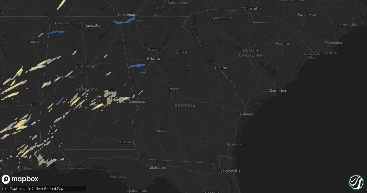
Hail Map in Georgia on January 3, 2023
Get this storm
January 3 map
$229
one time, instant access
Download today. No call, no setup
Keep the $229
Bought the map and want the full workflow? Apply the entire $229 to a subscription within 7 days. None of it is wasted.
Every map, not just this one
This buys you this map. Subscription and you get every map we run, in the markets you choose from a few cities to whole states to nationwide. Plus real-time alerts the moment a storm fires.
Contact data
Name, contact info, occupancy, even credit band for addresses in the footprint. You go from where it hit to who to call.
Become the source they trust
Unlimited branding weather history reports on demand. You already have the documented answer ready for the property owner, and you are the one who showed up with it.
Property data and RoofTrace estimates
Pull up any address you have got, its value and the exact code rules for that jurisdiction, straight from One Click Code. Then RoofTrace estimates the squares, pitch, and roof value, priced the way you price.
Storm reports in Georgia
Georgia
| Date | Description |
|---|---|
| 01/03/20234:45 PM CST | Several reports of trees and/or powerlines down in south fulton county on tuesday... In the area around fairburn and union city... West of the i-85/i-285 interchange. M |
| 01/03/20234:42 PM CST | 15-20 trees down along sullivan rd. |
| 01/03/20234:12 PM CST | Several trees down along five notch road. |
| 01/03/20234:12 PM CST | Tree down on a house off of brock street. |
| 01/03/20234:00 PM CST | Tree down on yarbrough rd. |
| 01/03/20233:57 PM CST | Tree down on wilson rd. |
| 01/03/20233:36 PM CST | Tree down at akes station rd. |
| 01/03/20231:45 PM CST | Tree down on cloverdale rd and morgan rd. |
| 01/03/20231:45 PM CST | Tree down on cloverdale rd and m |
| 01/03/20231:31 PM CST | Tree down on white oak gap rd. |
| 01/03/20234:45 AM CST | Reports of a couple trees down wednesday morning on koweta rd and enon rd in the south fulton area. |
| 01/03/20234:45 AM CST | Multiple trees down and a parked semi-truck overturned near the intersection of turner road and hwy 362. |
| 01/03/20234:29 AM CST | Tree down at aspen dr and skyview dr. |
| 01/03/20234:19 AM CST | Tree down near cul-de-sac on professional pkwy in douglas county. |
| 01/03/20234:17 AM CST | Asos station kpdk peachtree dekalb; reports of planes that were tied down pushed sideways by the strong winds. |
| 01/03/20234:17 AM CST | Tree down at liberty rd and e liberty rd in douglas county. |
| 01/03/20234:01 AM CST | Multiple trees down. One trailer destroyed along roosterville road. No injuries. Tds seen on radar. |
| 01/03/20232:48 AM CST | Multiple trees down... Including a tree down on a structure. No injuries reported. |
| 01/03/202312:25 AM CST | At 625 PM EST, a severe thunderstorm was located over North Fort Benning, or 8 miles north of Cusseta, moving northeast at 40 mph. HAZARD...60 mph wind gusts. SOURCE...Radar indicated. IMPACT...Expect damage to roofs, siding, and trees. Locations impacted include... North Fort Benning, Sand Hill, Eelbeck/West Fort Benning and Vista Terrace. |
| 01/03/202312:21 AM CST | At 621 PM EST, a severe thunderstorm was located 7 miles northwest of Edison, or 8 miles south of Cuthbert, moving northeast at 40 mph. HAZARD...60 mph wind gusts. SOURCE...Radar indicated. IMPACT...Expect damage to roofs, siding, and trees. Locations impacted include... Dawson, Shellman, Sasser, Bronwood, Parrott, Pachitla, Carnegie, Bridges Crossroad, Moye, Herod, Randolph Co A/p, Yeomans, Dawson Municipal A/P, Graves, Fountain Bridge, Goffs Mill, Shivers Mill, Aycock Mill, Oakville and Martins Crossroads. |
| 01/03/202312:12 AM CST | At 612 PM EST, a severe thunderstorm was located over Roberta, moving east at 25 mph. HAZARD...60 mph wind gusts. SOURCE...Radar indicated. IMPACT...Expect damage to roofs, siding, and trees. Locations impacted include... Macon, Roberta, Payne, Payne City, Lake Tobesofkee, Jack Brown Estates, Rutland, Musella, Knoxville, Wesleyan, Lizella, Skipperton, Sandy Point and Horns. |
| 01/02/202311:52 PM CST | At 552 PM EST, a severe thunderstorm was located near Peachtree City, or near Fayetteville, moving east at 40 mph. HAZARD...60 mph wind gusts. SOURCE...Radar indicated. IMPACT...Expect damage to roofs, siding, and trees. Locations impacted include... Griffin, Fayetteville, Jonesboro, Peachtree City, Stockbridge, Riverdale, Hampton, Tyrone, Morrow, Lovejoy, Senoia, Brooks, Sharpsburg, Turin, Woolsey, Sunny Side, Lake Spivey, Starrs Mill, Walker Mill and Inman. |
| 01/02/202311:39 PM CST | At 539 PM EST, severe thunderstorms were located along a line extending from near Winston to Chapel Hill to Campbellton to near Palmetto to near Cannongate, moving east at 45 mph. HAZARD...60 mph wind gusts. SOURCE...Radar indicated. IMPACT...Expect damage to roofs, siding, and trees. Locations impacted include... Atlanta, Douglasville, City of South Fulton, Smyrna, East Point, Union City, Forest Park, Riverdale, College Park, Powder Springs, Fairburn, Austell, Morrow, Hapeville, Palmetto, Lake City, Lithia Springs, Hartsfield-Jackson Airport, Midtown and Grant Park-Zoo Atlanta. |
| 01/02/202311:24 PM CST | At 523 PM EST, a severe thunderstorm was located near East Newnan, or near Newnan, moving east at 45 mph. HAZARD...60 mph wind gusts. SOURCE...Radar indicated. IMPACT...Expect damage to roofs, siding, and trees. Locations impacted include... Newnan, Peachtree City, Tyrone, Palmetto, Senoia, Grantville, Moreland, Sharpsburg, Turin, Haralson, East Newnan, Starrs Mill, Arnco-Sargent, Cannongate, Thomas Crossroads and Madras. |
| 01/02/202311:12 PM CST | At 512 PM EST, severe thunderstorms were located along a line extending from near Temple to near Clem to near Lowell, moving east at 45 mph. HAZARD...60 mph wind gusts. SOURCE...Radar indicated. IMPACT...Expect damage to roofs, siding, and trees. Locations impacted include... Douglasville, Carrollton, City of South Fulton, Villa Rica, Palmetto, Temple, Whitesburg, Chattahoochee Hills, Lithia Springs, Plant Yates, Bill Arp, Seaton Lake, Fairplay, Dunaway Gardens, Clem, Abilene, Winston, Lake Val-Do-Mar, Campbellton and Byers Crossroads. |
| 01/02/202311:11 PM CST | At 511 PM EST, a severe thunderstorm was located over Geneva, or 9 miles south of Talbotton, moving northeast at 35 mph. HAZARD...60 mph wind gusts. SOURCE...Radar indicated. IMPACT...Expect damage to roofs, siding, and trees. Locations impacted include... Talbotton, Junction City, Geneva, Howard, Marion Estates, Juniper, Baldwinville, Prattsburg, Wesley Church, Po Biddy Crossroads and Carsonville. |
| 01/02/20239:32 PM CST | At 332 PM EST, severe thunderstorms were located along a line extending from 16 miles northwest of Murphy to near Ducktown, moving east at 45 mph. HAZARD...60 mph wind gusts. SOURCE...Radar indicated. IMPACT...Expect damage to roofs, siding, and trees. Locations impacted include... Andrews, Murphy, Ducktown, Hayesville, William L. Davenport Refuge, Tusquitee, Violet, Turtletown, Copperhill and Hiawasse Dam. |
| 01/02/20239:32 PM CST | At 331 PM CST, severe thunderstorms were located along a line extending from near Oak Bowery to near Tuskegee, moving east at 35 mph. HAZARD...60 mph wind gusts. SOURCE...Radar indicated. IMPACT...Expect damage to roofs, siding, and trees. Locations impacted include... Auburn, Opelika, River View, Beulah, Beauregard, Beans Mill, Auburn University, Fairfax, Loachapoka, Robert G. Pitts Airport, Chewacla State Park and Mount Jefferson. |
| 01/02/20238:56 PM CST | At 256 PM CST, severe thunderstorms were located along a line extending from near Jacksons' Gap to near Dadeville to near Martin Dam, moving east at 40 mph. HAZARD...60 mph wind gusts. SOURCE...Radar indicated. IMPACT...Expect damage to roofs, siding, and trees. Locations impacted include... Valley, Lanett, Dadeville, Camp Hill, Lafayette, Stroud, La Fayette, Jacksons' Gap, Waverly, Lakeview, Five Points, Cusseta, Post Oak Forks, Denson, Amity Park, Sturkie, Standing Rock, Trammel Crossroads, Ridge Grove and Buffalo. |
| 01/02/20238:46 PM CST | At 245 PM EST, severe thunderstorms were located along a line extending from near Charleston to near South Cleveland to near Ringgold, moving east at 45 mph. HAZARD...60 mph wind gusts. SOURCE...Radar indicated. IMPACT...Expect damage to roofs, siding, and trees. Locations impacted include... Cleveland, Benton, Ducktown, South Cleveland, East Cleveland, Wildwood Lake, Collegedale, William L. Davenport Refuge, Waterville and Big Frog Mountain.This includes Interstate 75 in Tennessee between mile markers 22 and28. |
| 01/02/20236:00 PM CST | Tree down at beaumont heights and williamson rd. |
All States Impacted by Hail Map on January 3, 2023
Cities Impacted by Hail Map on January 3, 2023
- Jasper, AL
- Scooba, MS
- Emelle, AL
- Aliceville, AL
- Eutaw, AL
- Ralph, AL
- Knoxville, AL
- Buhl, AL
- Ethel, MS
- Kosciusko, MS
- Carthage, MS
- Bastrop, LA
- Fayette, AL
- Millbrook, AL
- Coosada, AL
- Billingsley, AL
- Plantersville, AL
- Heidelberg, MS
- Shubuta, MS
- Deatsville, AL
- Decatur, MS
- Conehatta, MS
- Hermanville, MS
- Notasulga, AL
- Tallassee, AL
- Tuskegee, AL
- Port Allen, LA
- Brusly, LA
- Soso, MS
- Stringer, MS
- Laurel, MS
- McIntosh, AL
- Tibbie, AL
- State Line, MS
- Richton, MS
- Theriot, LA
- Gibson, LA
- Moreauville, LA
- Monterey, LA
- Marksville, LA
- Perkinston, MS
- Brooklyn, MS
- Beaumont, MS
- Wiggins, MS
- Thomasville, AL
- Pine Hill, AL
- Arlington, AL
- Walnut Grove, MS
- Philadelphia, MS
- Lena, MS
- Waynesboro, MS
- Vidalia, LA
- Woodville, MS
- Natchez, MS
- Farmer City, IL
- Waynesboro, TN
- Lawrenceburg, TN
- Collinwood, TN
- Hohenwald, TN
- Citronelle, AL
- Convent, LA
- Saint James, LA
- Gloster, MS
- Liberty, MS
- Raceland, LA
- Houma, LA
- Bourg, LA
- Dry Creek, LA
- Sugartown, LA
- Little River, AL
- Poplarville, MS
- Carriere, MS
- Bunkie, LA
- Sturgis, MS
- Ackerman, MS
- Mathiston, MS
- Weir, MS
- Cottonport, LA
- Plaucheville, LA
- Evergreen, LA
- Auburn, AL
- Opelika, AL
- Wapella, IL
- Clinton, IL
- Bellflower, IL
- Mansfield, IL
- Saint Stephens, AL
- Millry, AL
- Baton Rouge, LA
- Shiloh, GA
- Hamilton, GA
- Acme, LA
- Hessmer, LA
- Mansura, LA
- Pike Road, AL
- Montgomery, AL
- Vossburg, MS
- Autaugaville, AL
- Prattville, AL
- Caledonia, MS
- Columbus, MS
- Steens, MS
- Slidell, LA
- Oakdale, LA
- Coffeeville, AL
- Boyce, LA
- Elmer, LA
- Sieper, LA
- Otis, LA
- Fayette, MS
- Grant, LA
- Deridder, LA
- Elizabeth, LA
- Pitkin, LA
- Lacombe, LA
- Lafayette, LA
- Collins, MS
- Prairieville, LA
- Denham Springs, LA
- Saint Gabriel, LA
- Addis, LA
- Plaquemine, LA
- Sunshine, LA
- Greenwell Springs, LA
- Weldon, IL
- Maroa, IL
- Dewitt, IL
- Lane, IL
- Gadsden, AL
- Ohatchee, AL
- Ashville, AL
- Bay Springs, MS
- Pennington, AL
- La Place, LA
- Ponchatoula, LA
- Sunflower, AL
- Wagarville, AL
- Jeanerette, LA
- Saint Landry, LA
- Ville Platte, LA
- Simmesport, LA
- Tuscaloosa, AL
- Brookwood, AL
- Cottondale, AL
- Noxapater, MS
- Louisville, MS
- Canton, MS
- Camden, MS
- Uniontown, AL
- Lucedale, MS
- Vinegar Bend, AL
- Leakesville, MS
- Maplesville, AL
- Taylorsville, MS
- Ellisville, MS
- Latham, IL
- Warrensburg, IL
- Cataula, GA
- Wetumpka, AL
- Butler, AL
- Safford, AL
- Morton, MS
- Smiths Station, AL
- Salem, AL
- Fortson, GA
- Gallion, AL
- Sardis, AL
- Jones, AL
- Selma, AL
- Orrville, AL
- Columbia, MS
- Sumrall, MS
- Bassfield, MS
- Mittie, LA
- Morgan City, LA
- Franklin, LA
- Marion Junction, AL
- Marion, AL
- Roxie, MS
- Meadville, MS
- Crosby, MS
- McHenry, MS
- Moselle, MS
- Cruger, MS
- Sidon, MS
- Melvin, AL
- Stapleton, AL
- Coila, MS
- Summit, MS
- Ruth, MS
- Deer Park, AL
- Jackson, AL
- Monticello, MS
- Jayess, MS
- Alexander City, AL
- Eclectic, AL
- Shorter, AL
- Camp Hill, AL
- Dadeville, AL
- Equality, AL
- Reeves, LA
- Rosedale, MS
- McCool, MS
- Tyler, AL
- Hayneville, AL
- Mobile, AL
- Theodore, AL
- Grand Bay, AL
- Moss Point, MS
- Jonesville, LA
- Deville, LA
- Effie, LA
- Center Point, LA
- Pineville, LA
- Pachuta, MS
- Forest, MS
- Bay Saint Louis, MS
- Paulding, MS
- Sallis, MS
- Flora, MS
- Jackson, MS
- Madison, MS
- Clinton, MS
- Bolton, MS
- Brookhaven, MS
- Sontag, MS
- Hazlehurst, MS
- Wesson, MS
- Bogue Chitto, MS
- Starkville, MS
- Ashland, AL
- Talladega, AL
- Lineville, AL
- Millport, AL
- Vernon, AL
- Sulligent, AL
- Artesia, MS
- Kennedy, AL
- West Point, MS
- Lowndesboro, AL
- Bay Minette, AL
- Robertsdale, AL
- Loxley, AL
- Long Beach, MS
- Albany, LA
- Holden, LA
- Hope Hull, AL
- Mount Olive, MS
- Lockport, LA
- Grove Hill, AL
- Chatom, AL
- Magnolia, MS
- Bogalusa, LA
- Bush, LA
- Ragley, LA
- Carson, MS
- Prentiss, MS
- Vancleave, MS
- Saucier, MS
- Greensburg, LA
- Osyka, MS
- Loreauville, LA
- Saint Martinville, LA
- New Iberia, LA
- Tickfaw, LA
- Independence, LA
- McLain, MS
- Grosse Tete, LA
- Loranger, LA
- Husser, LA
- Abbeville, LA
- Erath, LA
- Clanton, AL
- Jachin, AL
- Ward, AL
- York, AL
- Catherine, AL
- Wilmer, AL
- Leroy, AL
- McCall Creek, MS
- Smithdale, MS
- Youngsville, LA
- Broussard, LA
- Lorman, MS
- Union Church, MS
- Cheneyville, LA
- Pattison, MS
- Faunsdale, AL
- Pass Christian, MS
- Gulfport, MS
- New Augusta, MS
- Seminary, MS
- Stockton, AL
- Oak Vale, MS
- Lumberton, MS
- Daphne, AL
- Irvington, AL
- Olive Branch, MS
- Myrtle, MS
- Titus, AL
- Louisville, AL
- Banks, AL
- Mount Auburn, IL
- Blue Mound, IL
- Niantic, IL
- Decatur, IL
- Sharpsburg, GA
- Newnan, GA
- Gibson City, IL
- Foosland, IL
- Lithonia, GA
- Whitesburg, GA
- Bowdon, GA
- Winston, GA
- Carrollton, GA
- Palmetto, GA
- Douglasville, GA
- Fairburn, GA
- Moreland, GA
- Chattanooga, TN
- Ooltewah, TN
- Apison, TN
- Chickamauga, GA
- Ringgold, GA
- Rising Fawn, GA
- Rock Spring, GA
- Higdon, AL
- Flat Rock, AL
- Trenton, GA
- Tunnel Hill, GA
- Stevenson, AL
- Red Bay, AL
- Belmont, MS
- Golden, MS
- Russellville, AL
- Dalton, GA
- Chatsworth, GA
- Elgin, IL
- Great Lakes, IL
- Lake Bluff, IL
- North Chicago, IL
- Linden, AL
- Demopolis, AL
- Greensboro, AL
- Lawley, AL
- Centreville, AL
- Randolph, AL
- Lafayette, AL
- Five Points, AL
- Mound Bayou, MS
- Clarksdale, MS
- Shelby, MS
- Baldwyn, MS
- Fulton, MS
- New Site, MS
- Mantachie, MS
- Marietta, MS
- Ethelsville, AL
- Quitman, MS
- Maben, MS


