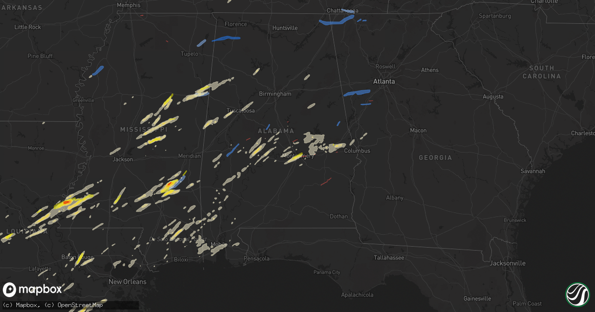
Hail Map on January 3, 2023
Get this storm
January 3 map
$229
one time, instant access
Download today. No call, no setup
Keep the $229
Bought the map and want the full workflow? Apply the entire $229 to a subscription within 7 days. None of it is wasted.
Every map, not just this one
This buys you this map. Subscription and you get every map we run, in the markets you choose from a few cities to whole states to nationwide. Plus real-time alerts the moment a storm fires.
Contact data
Name, contact info, occupancy, even credit band for addresses in the footprint. You go from where it hit to who to call.
Become the source they trust
Unlimited branding weather history reports on demand. You already have the documented answer ready for the property owner, and you are the one who showed up with it.
Property data and RoofTrace estimates
Pull up any address you have got, its value and the exact code rules for that jurisdiction, straight from One Click Code. Then RoofTrace estimates the squares, pitch, and roof value, priced the way you price.
Storm reports
Louisiana
| Date | Description |
|---|---|
| 01/03/20233:15 PM CST | Occurred near monterey... Report via social media. |
| 01/03/20232:58 PM CST | Dime to quarter hail. |
| 01/03/20236:35 AM CST | At 1235 PM CST, a severe thunderstorm was located over Sugartown, moving northeast at 35 mph. HAZARD...60 mph wind gusts and quarter size hail. SOURCE...Radar indicated. IMPACT...Hail damage to vehicles is expected. Expect wind damage to roofs, siding, and trees. Locations impacted include... Oakdale, Elizabeth, Pitkin, Sugartown, Grant and Union Hill. |
| 01/03/20235:37 AM CST | At 1137 PM CST, severe thunderstorms were located along a line extending from near Crossroads to near Mcneil, moving east at 45 mph. HAZARD...60 mph wind gusts and quarter size hail. SOURCE...Radar indicated. IMPACT...Hail damage to vehicles is expected. Expect wind damage to roofs, siding, and trees. Locations impacted include... Poplarville, Crossroads and Mcneil. This includes Interstate 59 in Mississippi between mile markers 10and 42. |
| 01/03/20231:47 AM CST | At 747 PM CST, a severe thunderstorm was located near Shenandoah, or near Denham Springs, moving northeast at 45 mph. HAZARD...Quarter size hail. SOURCE...Radar indicated. IMPACT...Damage to vehicles is expected. Locations impacted include... Baton Rouge, Denham Springs, Oak Hills Place, Walker, Livingston, Port Vincent, Old Jefferson, Village St. George, Inniswold, Shenandoah and Gardere.This includes the following Interstates... Interstate 10 in Louisiana between mile markers 163 and 168. Interstate 12 between mile markers 5 and 26. |
| 01/03/20231:30 AM CST | At 729 AM CST, a severe thunderstorm was located over Harmony, or near Oberlin, moving northeast at 40 mph. HAZARD...60 mph wind gusts and quarter size hail. SOURCE...Radar indicated. IMPACT...Hail damage to vehicles is expected. Expect wind damage to roofs, siding, and trees. Locations impacted include... Oberlin. |
| 01/03/20231:22 AM CST | At 722 AM CST, a severe thunderstorm was located near Bakers, or 17 miles northeast of Winnsboro, moving east at 40 mph. HAZARD...60 mph wind gusts. SOURCE...Radar indicated. IMPACT...Expect damage to roofs, siding, and trees. This severe thunderstorm will be near... Tendal around 735 AM CST. Tallulah around 750 AM CST. Mansford and Omega around 755 AM CST.Other locations impacted by this severe thunderstorm include Mound,Delta and Richmond. |
| 01/03/20231:18 AM CST | At 718 AM CST, a severe thunderstorm was located near Monticello, or 10 miles west of Transylvania, moving northeast at 60 mph. HAZARD...60 mph wind gusts. SOURCE...Radar indicated. IMPACT...Expect damage to roofs, siding, and trees. This severe thunderstorm will be near... Alsatia around 725 AM CST. Transylvania around 730 AM CST. Lake Providence and Fitler around 735 AM CST.Other locations impacted by this severe thunderstorm includeMayersville, Pioneer and Forest. |
| 01/03/202312:56 AM CST | At 656 AM CST, severe thunderstorms were located along a line extending from near Snyder to 7 miles southwest of Beekman, moving east at 35 mph. HAZARD...60 mph wind gusts. SOURCE...Radar indicated. IMPACT...Expect damage to roofs, siding, and trees. Severe thunderstorms will be near... Snyder around 700 AM CST. Montrose around 705 AM CST. Galion around 720 AM CST. Jones around 730 AM CST. Wilmot around 740 AM CST.Other locations impacted by these severe thunderstorms includeBonita. |
| 01/03/202312:17 AM CST | At 617 PM CST, a severe thunderstorm was located near Broussard, or near St. Martinville, moving northeast at 35 mph. HAZARD...60 mph wind gusts and quarter size hail. SOURCE...Radar indicated. IMPACT...Hail damage to vehicles is expected. Expect wind damage to roofs, siding, and trees. Locations impacted include... Lafayette, Catahoula, Breaux Bridge, St. Martinville, Broussard, Youngsville, Henderson, Butte La Rose, Atchafalaya Welcome Center, Atchafalaya National Wildlife Refuge and Parks.This includes Interstate 10 in Louisiana between mile markers 115 and126. |
| 01/03/202312:11 AM CST | At 610 PM CST, a severe thunderstorm was located over Mansura, or over Marksville, moving northeast at 35 mph. HAZARD...60 mph wind gusts and quarter size hail. SOURCE...Radar indicated. IMPACT...Hail damage to vehicles is expected. Expect wind damage to roofs, siding, and trees. Locations impacted include... Marksville, Moreauville, Bordelonville, Mansura, Hessmer, Brouillette and Lake Ophelia National Wildlife Refuge. |
| 01/02/202311:47 PM CST | Broadcast media report relayed via social media of hail estimated between quarter to half-dollar sized near essen & jefferson highway. |
| 01/02/202310:22 PM CST | At 421 PM CST, a severe thunderstorm was located near Oakdale, moving northeast at 35 mph. HAZARD...60 mph wind gusts and quarter size hail. SOURCE...Radar indicated. IMPACT...Hail damage to vehicles is expected. Expect wind damage to roofs, siding, and trees. Locations impacted include... Oakdale, Glenmora, Elizabeth, Turkey Creek, Beaver, Forest Hill and Mcnary. |
| 01/02/20239:58 PM CST | At 357 PM CST, a severe thunderstorm was located near Gillsburg, or 10 miles south of Liberty, moving northeast at 40 mph. HAZARD...Quarter size hail. SOURCE...Radar indicated. IMPACT...Damage to vehicles is expected. Locations impacted include... Mccomb, Magnolia, Summit, Gillsburg and Mccomb Airport. This includes Interstate 55 in Mississippi between mile markers 3 and21. |
| 01/02/20239:53 PM CST | Update- pictures were received from emergency management and after a discussion with the emergency manager... Analyzing the pictures and comparing them to radar data... |
| 01/02/20239:53 PM CST | Power lines down and roof damage near the intersection of fornea rd and jones creek rd. Time estimated by radar. |
| 01/02/20239:52 PM CST | At 351 AM CST, severe thunderstorms were located along a line extending from Greenwood to 8 miles west of Stonewall to 12 miles north of Logansport, moving northeast at 40 mph. HAZARD...60 mph wind gusts and quarter size hail. SOURCE...Radar indicated. IMPACT...Hail damage to vehicles is expected. Expect wind damage to roofs, siding, and trees. Locations impacted include... Shreveport, Bossier City, Haughton, Greenwood, Blanchard, Benton, Stonewall, Eastwood, Fosters, Keachi, Longstreet, Keat Chie, Ferguson, Spring Ridge, Fillmore, Cross Lake, Bodcau, Kickapoo, Keithville and Ivan. |
Tennessee
| Date | Description |
|---|---|
| 01/03/20233:15 PM CST | Trees down leading to power outages. |
| 01/03/20232:40 PM CST | Large tree down with property damage to structure and fence. Reported by trained spotter. |
| 01/03/20232:25 PM CST | Numerous shingles blown off roof... And trees down. |
| 01/03/20232:20 PM CST | Several trees down. |
| 01/03/20232:10 PM CST | Trees down on smith school rd. |
| 01/03/20232:10 PM CST | Several trees down across the county. |
| 01/03/20232:06 PM CST | Numerous trees down across the county. |
| 01/03/20232:00 PM CST | Trees and powerlines down on ellistown rd. |
| 01/03/20231:55 PM CST | Several trees down. |
| 01/03/20231:50 PM CST | Several trees down across the county. |
| 01/03/20231:32 PM CST | Corrects previous non-tstm wnd gst report from 4 se chattanooga. Measured at the asos station kcha lovell field from thunderstorm winds. In addition... Public report of |
| 01/03/202312:30 PM CST | Thunderstorm wind damage reported in crossville. Damage included an uprooted tree... A torn roof off of a building... And shingle damage to a residence. |
| 01/03/202312:22 PM CST | Thunderstorm wind damage reported on tabor loop north of crossville. Damage included a tree that fell onto a house... A damaged carport and garage... Another uprooted t |
| 01/03/202312:22 PM CST | Corrects previous tstm wnd dmg report from 1 n crossville. Thunderstorm wind damage reported on tabor loop north of crossville. Damage included a tree that fell onto a |
| 01/03/202311:15 AM CST | Thunderstorm winds destroyed shed at a residence near unionville. |
| 01/03/202311:00 AM CST | Tspotter report of downed trees along the railroad tracks in fosterville. A roof was also torn off of a hay shed near the intersection of fosterville and bell buckle ro |
| 01/03/202310:59 AM CST | Tspotter report of downed trees along the railroad tracks south of fosterville near bell buckle road at fosterville road. A roof was also torn off of a nearby hay shed. |
| 01/03/202310:59 AM CST | Corrects previous tstm wnd dmg report from 5 nnw bell buckle. Tspotter report of downed trees along the railroad tracks south of fosterville near bell buckle road at fo |
| 01/03/202310:45 AM CST | Corrects previous tstm wnd dmg report from unionville. Thunderstorm winds destroyed shed at a residence near unionville. |
| 01/03/202310:45 AM CST | Thunderstorm winds destroyed shed at a residence near unionville. |
| 01/03/20236:09 AM CST | At 1208 PM CST, a severe thunderstorm was located near Monterey, or 14 miles northeast of Sparta, moving northeast at 50 mph. HAZARD...60 mph wind gusts. SOURCE...Radar indicated. IMPACT...Expect damage to roofs, siding, and trees. Locations impacted include... Crossville, Fairfield Glade, Monterey, Crab Orchard, Pleasant Hill, Grimsley, Lake Tansi, Cumberland Mountain State Park, Slate Springs, Clarkrange and Virgin Falls State Natural Area.This includes Interstate 40 between mile markers 292 and 340. |
| 01/03/20235:39 AM CST | At 1139 PM CST, a severe thunderstorm was located near Waynesboro, moving northeast at 50 mph. HAZARD...60 mph wind gusts and quarter size hail. SOURCE...Radar indicated. IMPACT...Hail damage to vehicles is expected. Expect wind damage to roofs, siding, and trees. Locations impacted include... Hohenwald, Waynesboro, Gordonsburg and Kimmins. |
| 01/03/20235:32 AM CST | At 1132 AM CST, a severe thunderstorm was located near Smithville, moving northeast at 40 mph. HAZARD...60 mph wind gusts. SOURCE...Radar indicated. IMPACT...Expect damage to roofs, siding, and trees. Locations impacted include... Cookeville, McMinnville, Sparta, Smithville, Woodbury, Spencer, Algood, Monterey, Baxter, Pleasant Hill, Doyle, Dowelltown, Liberty, Centertown, Hamptons Crossroads, Bakers Crossroads, Virgin Falls State Natural Area, Burgess Falls State Park, Rock Island State Park and Center Hill Lake.This includes Interstate 40 between mile markers 267 and 300. |
| 01/03/202312:42 AM CST | At 641 AM CST, a severe thunderstorm was located over Portland, moving northeast at 55 mph. HAZARD...60 mph wind gusts. SOURCE...Radar indicated. IMPACT...Expect damage to roofs, siding, and trees. Locations impacted include... Scottsville. |
| 01/03/202312:40 AM CST | At 640 AM CST, a severe thunderstorm was located near Cloverport, or 8 miles northwest of Bolivar, moving east at 35 mph. HAZARD...60 mph wind gusts. SOURCE...Radar indicated. IMPACT...Expect damage to roofs, siding, and trees. Locations impacted include... Henderson, Bolivar, Chickasaw State Forest, Chickasaw State Park, Whiteville, Silerton, Masseyville, Cloverport, Toone, Medon, Pinson, Pine Top, Parkburg, Vildo, Hatchie, Uptonville, Hickory Corners, Deanburg, Teague and Montezuma. |
| 01/03/202312:28 AM CST | At 628 AM CST, a severe thunderstorm was located over Red Banks, or near Holly Springs, moving east at 35 mph. HAZARD...60 mph wind gusts. SOURCE...Radar indicated. IMPACT...Expect damage to roofs, siding, and trees. Locations impacted include... Holly Springs, Ripley, Lamar, Snow Lake Shores, Canaan, Mt Pleasant, Gravestown, Michigan City, Red Banks, Slayden, Marianna, Walnut, Ashland, Falkner, Murry, Brody, Spring Hill, Higdon, Gilton and New Canaan. |
| 01/02/202311:51 PM CST | Quarter size hail reported on buffalo road south of hohenwald. |
| 01/02/202311:50 PM CST | A local report indicates 1.00 inch wind near 2.2 SE HOHENWALD |
| 01/02/202311:42 PM CST | At 542 AM CST, a severe thunderstorm was located over Hernando, moving east at 45 mph. HAZARD...60 mph wind gusts. SOURCE...Radar indicated. IMPACT...Expect damage to roofs, siding, and trees. Locations impacted include... Hernando, Senatobia, Holly Springs, Wall Doxey State Park, Lamar, Coldwater, Byhalia, Como, Crenshaw, Sledge, Snow Lake Shores, Mt Pleasant, Strayhorn, Lewisburg, Arkabutla, Michigan City, Red Banks, Laws Hill, Barr and Canaan. |
| 01/02/202310:12 PM CST | At 412 AM CST, severe thunderstorms were located along a line extending from near Cobb to 9 miles northwest of Big Rock, moving east at 40 mph. HAZARD...60 mph wind gusts. SOURCE...Radar indicated. IMPACT...Expect damage to roofs, siding, and trees. Severe thunderstorms will be near... Crofton around 430 AM CST.Other locations in the path of these severe thunderstorms includeHopkinsville, Oak Grove and Fort Campbell.This includes the following highways... Interstate 24 in Kentucky between Mile Markers 59 and 91. Pennyrile Parkway between Mile Markers 1 and 25. |
| 01/02/20239:44 PM CST | At 343 AM CST, a severe thunderstorm was located near Springville, or near Paris, moving northeast at 55 mph. HAZARD...60 mph wind gusts. SOURCE...Radar indicated. IMPACT...Expect damage to roofs, siding, and trees. Locations impacted include... Paris, Paris Landing State Park, Vale, Springville, Routon, Big Sandy, Henry, Mansfield, Haigler Ridge, Manleyville, Old Springville, India, Sunnyside, Van Dyke, Mixie, Spring Creek, Crews Store, Ephesus and Big Sandy Unit Tennessee National Wildlife Refuge. |
| 01/02/20239:06 PM CST | At 305 PM EST, severe thunderstorms were located along a line extending from 8 miles west of Rutledge to 6 miles southeast of Plainview to near Rockford, moving east at 55 mph. HAZARD...60 mph wind gusts. SOURCE...Radar indicated. IMPACT...Expect damage to roofs, siding, and trees. Locations impacted include... Knoxville, Morristown, Sevierville, Alcoa, Jefferson City, Newport, Rogersville, Dandridge, Rutledge and Pigeon Forge.This includes the following highways... Interstate 40 in Tennessee between mile markers 394 and 432. Interstate 81 in Tennessee between mile markers 1 and 24. |
| 01/02/20238:41 PM CST | At 241 PM EST, severe thunderstorms were located along a line extending from 9 miles southeast of La Follette to near Clinton to near Farragut, moving east at 40 mph. HAZARD...60 mph wind gusts. SOURCE...Radar indicated. IMPACT...Expect damage to roofs, siding, and trees. Locations impacted include... Knoxville, Oak Ridge, Clinton, Alcoa, Maynardville, Farragut, Louisville, Plainview, Rockford and Strawberry Plains.This includes the following highways... Interstate 40 in Tennessee near mile marker 363, and between milemarkers 369 and 401. Interstate 75 in Tennessee between mile markers 108 and 125. |
| 01/02/20238:39 PM CST | At 238 PM EST, severe thunderstorms were located along a line extending from 6 miles south of Fairview to 8 miles north of Charleston to 6 miles northwest of Cleveland, moving east at 40 mph. HAZARD...60 mph wind gusts. SOURCE...Radar indicated. IMPACT...Expect damage to roofs, siding, and trees. Locations impacted include... Cleveland, Athens, Dayton, Sweetwater, Madisonville, Decatur, Soddy-Daisy, Etowah, Charleston and Englewood.This includes Interstate 75 in Tennessee between mile markers 28 and66. |
| 01/02/20238:17 PM CST | At 216 PM EST/116 PM CST/, a severe thunderstorm was located near Lookout Mountain, or 9 miles west of Chattanooga, moving east at 45 mph. HAZARD...60 mph wind gusts. SOURCE...Radar indicated. IMPACT...Expect damage to roofs, siding, and trees. Locations impacted include... Chattanooga, Cleveland, Soddy-Daisy, Signal Mountain, Walden, Lakesite, Ridgeside, South Cleveland, Fairmount and Harrison.This includes Interstate 75 in Tennessee between mile markers 1 and28. |
Georgia
| Date | Description |
|---|---|
| 01/03/20234:45 PM CST | Several reports of trees and/or powerlines down in south fulton county on tuesday... In the area around fairburn and union city... West of the i-85/i-285 interchange. M |
| 01/03/20234:42 PM CST | 15-20 trees down along sullivan rd. |
| 01/03/20234:12 PM CST | Tree down on a house off of brock street. |
| 01/03/20234:12 PM CST | Several trees down along five notch road. |
| 01/03/20234:00 PM CST | Tree down on yarbrough rd. |
| 01/03/20233:57 PM CST | Tree down on wilson rd. |
| 01/03/20233:36 PM CST | Tree down at akes station rd. |
| 01/03/20231:45 PM CST | Tree down on cloverdale rd and morgan rd. |
| 01/03/20231:45 PM CST | Tree down on cloverdale rd and m |
| 01/03/20231:31 PM CST | Tree down on white oak gap rd. |
| 01/03/20234:45 AM CST | Reports of a couple trees down wednesday morning on koweta rd and enon rd in the south fulton area. |
| 01/03/20234:45 AM CST | Multiple trees down and a parked semi-truck overturned near the intersection of turner road and hwy 362. |
| 01/03/20234:29 AM CST | Tree down at aspen dr and skyview dr. |
| 01/03/20234:19 AM CST | Tree down near cul-de-sac on professional pkwy in douglas county. |
| 01/03/20234:17 AM CST | Tree down at liberty rd and e liberty rd in douglas county. |
| 01/03/20234:17 AM CST | Asos station kpdk peachtree dekalb; reports of planes that were tied down pushed sideways by the strong winds. |
| 01/03/20234:01 AM CST | Multiple trees down. One trailer destroyed along roosterville road. No injuries. Tds seen on radar. |
| 01/03/20232:48 AM CST | Multiple trees down... Including a tree down on a structure. No injuries reported. |
| 01/03/202312:25 AM CST | At 625 PM EST, a severe thunderstorm was located over North Fort Benning, or 8 miles north of Cusseta, moving northeast at 40 mph. HAZARD...60 mph wind gusts. SOURCE...Radar indicated. IMPACT...Expect damage to roofs, siding, and trees. Locations impacted include... North Fort Benning, Sand Hill, Eelbeck/West Fort Benning and Vista Terrace. |
| 01/03/202312:21 AM CST | At 621 PM EST, a severe thunderstorm was located 7 miles northwest of Edison, or 8 miles south of Cuthbert, moving northeast at 40 mph. HAZARD...60 mph wind gusts. SOURCE...Radar indicated. IMPACT...Expect damage to roofs, siding, and trees. Locations impacted include... Dawson, Shellman, Sasser, Bronwood, Parrott, Pachitla, Carnegie, Bridges Crossroad, Moye, Herod, Randolph Co A/p, Yeomans, Dawson Municipal A/P, Graves, Fountain Bridge, Goffs Mill, Shivers Mill, Aycock Mill, Oakville and Martins Crossroads. |
| 01/03/202312:12 AM CST | At 612 PM EST, a severe thunderstorm was located over Roberta, moving east at 25 mph. HAZARD...60 mph wind gusts. SOURCE...Radar indicated. IMPACT...Expect damage to roofs, siding, and trees. Locations impacted include... Macon, Roberta, Payne, Payne City, Lake Tobesofkee, Jack Brown Estates, Rutland, Musella, Knoxville, Wesleyan, Lizella, Skipperton, Sandy Point and Horns. |
| 01/02/202311:52 PM CST | At 552 PM EST, a severe thunderstorm was located near Peachtree City, or near Fayetteville, moving east at 40 mph. HAZARD...60 mph wind gusts. SOURCE...Radar indicated. IMPACT...Expect damage to roofs, siding, and trees. Locations impacted include... Griffin, Fayetteville, Jonesboro, Peachtree City, Stockbridge, Riverdale, Hampton, Tyrone, Morrow, Lovejoy, Senoia, Brooks, Sharpsburg, Turin, Woolsey, Sunny Side, Lake Spivey, Starrs Mill, Walker Mill and Inman. |
| 01/02/202311:39 PM CST | At 539 PM EST, severe thunderstorms were located along a line extending from near Winston to Chapel Hill to Campbellton to near Palmetto to near Cannongate, moving east at 45 mph. HAZARD...60 mph wind gusts. SOURCE...Radar indicated. IMPACT...Expect damage to roofs, siding, and trees. Locations impacted include... Atlanta, Douglasville, City of South Fulton, Smyrna, East Point, Union City, Forest Park, Riverdale, College Park, Powder Springs, Fairburn, Austell, Morrow, Hapeville, Palmetto, Lake City, Lithia Springs, Hartsfield-Jackson Airport, Midtown and Grant Park-Zoo Atlanta. |
| 01/02/202311:24 PM CST | At 523 PM EST, a severe thunderstorm was located near East Newnan, or near Newnan, moving east at 45 mph. HAZARD...60 mph wind gusts. SOURCE...Radar indicated. IMPACT...Expect damage to roofs, siding, and trees. Locations impacted include... Newnan, Peachtree City, Tyrone, Palmetto, Senoia, Grantville, Moreland, Sharpsburg, Turin, Haralson, East Newnan, Starrs Mill, Arnco-Sargent, Cannongate, Thomas Crossroads and Madras. |
| 01/02/202311:12 PM CST | At 512 PM EST, severe thunderstorms were located along a line extending from near Temple to near Clem to near Lowell, moving east at 45 mph. HAZARD...60 mph wind gusts. SOURCE...Radar indicated. IMPACT...Expect damage to roofs, siding, and trees. Locations impacted include... Douglasville, Carrollton, City of South Fulton, Villa Rica, Palmetto, Temple, Whitesburg, Chattahoochee Hills, Lithia Springs, Plant Yates, Bill Arp, Seaton Lake, Fairplay, Dunaway Gardens, Clem, Abilene, Winston, Lake Val-Do-Mar, Campbellton and Byers Crossroads. |
| 01/02/202311:11 PM CST | At 511 PM EST, a severe thunderstorm was located over Geneva, or 9 miles south of Talbotton, moving northeast at 35 mph. HAZARD...60 mph wind gusts. SOURCE...Radar indicated. IMPACT...Expect damage to roofs, siding, and trees. Locations impacted include... Talbotton, Junction City, Geneva, Howard, Marion Estates, Juniper, Baldwinville, Prattsburg, Wesley Church, Po Biddy Crossroads and Carsonville. |
| 01/02/20239:32 PM CST | At 331 PM CST, severe thunderstorms were located along a line extending from near Oak Bowery to near Tuskegee, moving east at 35 mph. HAZARD...60 mph wind gusts. SOURCE...Radar indicated. IMPACT...Expect damage to roofs, siding, and trees. Locations impacted include... Auburn, Opelika, River View, Beulah, Beauregard, Beans Mill, Auburn University, Fairfax, Loachapoka, Robert G. Pitts Airport, Chewacla State Park and Mount Jefferson. |
| 01/02/20239:32 PM CST | At 332 PM EST, severe thunderstorms were located along a line extending from 16 miles northwest of Murphy to near Ducktown, moving east at 45 mph. HAZARD...60 mph wind gusts. SOURCE...Radar indicated. IMPACT...Expect damage to roofs, siding, and trees. Locations impacted include... Andrews, Murphy, Ducktown, Hayesville, William L. Davenport Refuge, Tusquitee, Violet, Turtletown, Copperhill and Hiawasse Dam. |
| 01/02/20238:56 PM CST | At 256 PM CST, severe thunderstorms were located along a line extending from near Jacksons' Gap to near Dadeville to near Martin Dam, moving east at 40 mph. HAZARD...60 mph wind gusts. SOURCE...Radar indicated. IMPACT...Expect damage to roofs, siding, and trees. Locations impacted include... Valley, Lanett, Dadeville, Camp Hill, Lafayette, Stroud, La Fayette, Jacksons' Gap, Waverly, Lakeview, Five Points, Cusseta, Post Oak Forks, Denson, Amity Park, Sturkie, Standing Rock, Trammel Crossroads, Ridge Grove and Buffalo. |
| 01/02/20238:46 PM CST | At 245 PM EST, severe thunderstorms were located along a line extending from near Charleston to near South Cleveland to near Ringgold, moving east at 45 mph. HAZARD...60 mph wind gusts. SOURCE...Radar indicated. IMPACT...Expect damage to roofs, siding, and trees. Locations impacted include... Cleveland, Benton, Ducktown, South Cleveland, East Cleveland, Wildwood Lake, Collegedale, William L. Davenport Refuge, Waterville and Big Frog Mountain.This includes Interstate 75 in Tennessee between mile markers 22 and28. |
| 01/02/20236:00 PM CST | Tree down at beaumont heights and williamson rd. |
North Carolina
| Date | Description |
|---|---|
| 01/03/20235:54 PM CST | Tree down on powerline at 282 blume rd in mooresville. |
| 01/03/20235:00 PM CST | Tree down in the area of 233 university circle in boone... Nc. |
| 01/03/20234:15 PM CST | Tree down in the area of elk creek road and old 421 south. |
| 01/03/20234:15 PM CST | Tree down in the area of old highway 421 and parkway school. |
| 01/03/20234:10 PM CST | Tree down in the area of howards creek road and joe j miller road. |
| 01/03/20234:04 PM CST | Tree down near intersection of highway 421 and 321. |
| 01/03/20234:03 PM CST | Tree down in the area of long ridge road and watauga river road. |
| 01/03/20233:59 PM CST | Trees down near beaver dam road. |
| 01/03/20232:54 PM CST | Vehicle hit by fallen tree near intersection of airport road and love rd. No injuries reported after ems visited the scene. Also one other report of a tree and powerlin |
| 01/02/202310:06 PM CST | At 406 PM EST, a severe thunderstorm was located near Andrews, moving east at 50 mph. HAZARD...60 mph wind gusts. SOURCE...Radar indicated. IMPACT...Expect damage to roofs, siding, and trees. Locations impacted include... Andrews, Hayesville, Nantahala Lake, Shooting Creek, Tusquitee, Topton and Brasstown. |
| 01/02/20239:23 PM CST | At 323 PM EST, severe thunderstorms were located along a line extending from 9 miles south of Maryville to 14 miles southeast of Madisonville to 12 miles north of Ducktown, moving east at 60 mph. HAZARD...60 mph wind gusts. SOURCE...Radar indicated. IMPACT...Expect damage to trees and power lines. Locations impacted include... Robbinsville, Town Of Santeetlah, Fontana Lake, Fontana Village, Lake Santeetlah, Smoky Mountains-Twentymile Creek, Tapoco, Deals Gap, Smoky Mountains-Fontana Area and Cheoah. |
| 01/02/20239:09 PM CST | At 308 PM EST, severe thunderstorms were located along a line extending from 13 miles northeast of Madisonville to 7 miles east of Benton, moving east at 50 mph. HAZARD...60 mph wind gusts. SOURCE...Law enforcement. IMPACT...Expect damage to roofs, siding, and trees. Locations impacted include... Vonore, Tellico Plains, Fort Loudon State Park, Coker Creek, Violet, Tariffville, McGee Carson Peninsula, Bullet Creek, Marble and Citico Beach. |
| 01/02/20239:04 PM CST | At 303 PM EST, severe thunderstorms were located along a line extending from near Louisville to 8 miles southeast of Lenoir City to 8 miles northeast of Madisonville, moving east at 40 mph. HAZARD...60 mph wind gusts. SOURCE...Radar indicated. IMPACT...Expect damage to roofs, siding, and trees. Locations impacted include... Maryville, Lenoir City, Alcoa, Farragut, Pigeon Forge, Louisville, Rockford, Eagleton Village, Smoky Mountains-Fontana Area and Vonore. |
Illinois
| Date | Description |
|---|---|
| 01/03/20235:59 PM CST | Power lines blown down. Possible tornado damage. Time estimated from radar. |
| 01/03/20235:59 PM CST | Photo shared via local broadcast media shows a tornado southeast of gibson city. Ford county em confirms two homesteads southeast of gibson city sustained damage from t |
| 01/03/20235:57 PM CST | Path length 0.2 miles... Width 25 yards. Damage occurred to an abandoned bowling alley along n. 22nd st. Spotter watched tornado cross road. Video from after the storm |
| 01/03/20235:57 PM CST | Spotter watched tornado cross road. Video from after the storm passed shows debris scattered about road and adjacent field. |
| 01/03/20235:56 PM CST | Nws storm survey found damage consistent with an ef1 tornado with estimated peak winds of 100 mph. Damage included loss of portions of a roof deck on two homes and coll |
| 01/03/20235:17 PM CST | Delayed report. Picture of hail just under golf ball size shared on social media. Time estimated from radar. |
| 01/03/20235:05 PM CST | A local report indicates a tornado near 4 ENE MOUNT AUBURN |
| 01/03/20234:38 PM CST | Grain bin damaged with debris on roadway near us-51 and washington st. Time estimated by radar. |
| 01/03/20234:36 PM CST | Corrects previous tornado report from 1 w maroa. Corrects time on previous tornado report from 1 w maroa and corrects outbuilding damaged instead of grain bin. Outbuild |
| 01/03/20234:36 PM CST | Path length 0.9 miles... Width 75 yards. Barn destroyed near the intersection of us-51 and washington st. Remains of a grain bin were tossed across the highway. A fence |
| 01/03/20234:36 PM CST | Corrects time on previous tornado report from 1 w maroa. Grain bin damaged with debris on roadway near us-51 and washington st. |
| 01/03/20234:33 PM CST | Path length 0.3 miles... Width 25 yards. Brief touchdown along bearsdale rd. North of school rd... Causing minor damage. |
| 01/03/20234:05 PM CST | A local report indicates a tornado near 3 SW LATHAM |
| 01/03/20233:52 PM CST | Confirmed tornado spotted in rural area west northwest of illiopolis moving northeast |
| 01/03/20233:52 PM CST | Confirmed tornado spotted in rural area west northwest of illiopolis moving northeast. |
| 01/03/20232:53 PM CST | Photos shared showing hailstones approximately one inch in diameter in waukegan. Time and location estimated from radar. |
| 01/03/20232:14 PM CST | Most hailstones were half an inch or less in diameter... But photos show that the largest hailstones were roughly one inch in diameter. |
Mississippi
| Date | Description |
|---|---|
| 01/03/20235:45 PM CST | Wind damage reported to transformer at substation. |
| 01/03/20235:22 PM CST | Tree fell on vehicle at intersection of monroe rd and moselle seminary rd. |
| 01/03/20235:06 PM CST | Reported near natchez. |
| 01/03/20235:06 PM CST | A local report indicates 1.00 inch wind near 1 S NATCHEZ |
| 01/03/20235:03 PM CST | Report via social media. |
| 01/03/20234:15 PM CST | Quarter size hail reported about 10 miles ne of natchez in jefferson co. |
| 01/03/202310:32 AM CST | Pictures on social media show a tree that knocked down power lines on highway 9. |
| 01/03/202310:26 AM CST | Multiple structures damaged and trees down in golden. Time is radar estimated. |
| 01/03/202310:08 AM CST | Tree fallen on one house and shingle damage to another house on dickerson rd. |
| 01/03/202310:06 AM CST | Roof damage to home off ramey rd. |
| 01/03/202310:06 AM CST | Numerous powerlines... Trees and single damage to homes in the houston community center area. |
| 01/03/20239:38 AM CST | Multiple trees down at whispering pines golf course. Time is radar estimated. |
| 01/03/20239:07 AM CST | A tornado touched down near highway 30 in union county and moved to the east-southeast along the highway. Damage team rated the tornado an ef1. |
| 01/03/20239:07 AM CST | Trees down across road which took the powerline out. |
| 01/03/20239:04 AM CST | Minor damage to a couple of homes and tree damage. |
| 01/03/20236:49 AM CST | A traffic light was damaged at ms hwy 8 and chrisman ave. |
| 01/03/20236:38 AM CST | Measured at a private farm weather station. |
| 01/03/20236:07 AM CST | Numerous stockade fences damaged or blown over in the braybourne subdivision just west of goodman road and cedar hill road. |
| 01/03/20236:04 AM CST | Corrects previous tornado report from 2 ese olive branch. A tornado debris signature was detected east of olive branch. |
| 01/03/20235:27 AM CST | At 1126 PM CST, a severe thunderstorm was located 4 miles east of Richton, moving northeast at 35 mph. HAZARD...60 mph wind gusts. SOURCE...Radar indicated. IMPACT...Expect damage to roofs, siding, and trees. Locations impacted include... Richton, State Line and Buckatunna. |
| 01/03/20234:44 AM CST | At 1044 PM CST, a severe thunderstorm was located over Steens, or near Columbus, moving northeast at 45 mph. HAZARD...60 mph wind gusts and quarter size hail. SOURCE...Radar indicated. IMPACT...Hail damage to vehicles is expected. Expect wind damage to roofs, siding, and trees. Locations impacted include... Vernon, Millport, Kennedy, Blooming Grove, Crossville, Cody, Star, Hightogy, Forest, Melborne and Shaw. |
| 01/03/20234:44 AM CST | At 1043 PM CST, a severe thunderstorm was located over Moss, or near Laurel, moving northeast at 40 mph. HAZARD...Ping pong ball size hail and 60 mph wind gusts. SOURCE...Radar indicated. IMPACT...People and animals outdoors will be injured. Expect hail damage to roofs, siding, windows, and vehicles. Expect wind damage to roofs, siding, and trees. This severe thunderstorm will be near... Sandersville around 1050 PM CST. Heidelberg around 1100 PM CST. Stafford Springs around 1105 PM CST. Goodwater and Barnett around 1110 PM CST.Other locations impacted by this severe thunderstorm include Pachutaand Shubuta. |
| 01/03/20234:39 AM CST | At 1039 AM CST, a severe thunderstorm was located near Sherwood, or 20 miles southwest of Montpelier, moving northeast at 50 mph. HAZARD...60 mph wind gusts. SOURCE...Radar indicated. IMPACT...Expect damage to roofs, siding, and trees. This severe thunderstorm will be near... Mathiston around 1045 AM CST. Maben, Cumberland and Clarkson around 1050 AM CST. Pheba around 1100 AM CST. Montpelier and Griffith around 1105 AM CST. Pala Alto around 1110 AM CST.Other locations impacted by this severe thunderstorm include Manteeand Walthall. |
| 01/03/20234:23 AM CST | At 1022 PM CST, a severe thunderstorm was located near Bethsaida, or 7 miles east of Philadelphia, moving northeast at 60 mph. HAZARD...60 mph wind gusts. SOURCE...Radar indicated. IMPACT...Expect damage to roofs, siding, and trees. This severe thunderstorm will be near... Nanih Waiya and Bluff Springs around 1035 PM CST. Preston around 1040 PM CST. Gholson around 1045 PM CST. Mashulaville around 1050 PM CST.Other locations impacted by this severe thunderstorm includeShuqualak and Tucker. |
| 01/03/20234:14 AM CST | At 1013 AM CST, severe thunderstorms were located along a line extending from near Midway to 6 miles south of Burton to near Fairview, moving east at 45 mph. HAZARD...60 mph wind gusts. SOURCE...Radar indicated. IMPACT...Expect damage to roofs, siding, and trees. Locations impacted include... Florence, Muscle Shoals, Russellville, Sheffield, Tuscumbia, Red Bay, Phil Campbell, Killen, Cherokee and Littleville. |
| 01/03/20234:04 AM CST | At 1004 PM CST, a severe thunderstorm was located over Taylorsville, or 9 miles west of Stringer, moving northeast at 40 mph. HAZARD...60 mph wind gusts and quarter size hail. SOURCE...Radar indicated. IMPACT...Hail damage to vehicles is expected. Expect wind damage to roofs, siding, and trees. This severe thunderstorm will be near... Stringer around 1015 PM CST. Bay Springs and Vernon around 1025 PM CST. Turnerville around 1035 PM CST.Other locations impacted by this severe thunderstorm includeSylvarena and Louin. |
| 01/03/20234:02 AM CST | At 1002 PM CST, a severe thunderstorm was located 7 miles northwest of Stallo, or 12 miles southwest of Louisville, moving northeast at 55 mph. HAZARD...60 mph wind gusts and half dollar size hail. SOURCE...Radar indicated. IMPACT...Hail damage to vehicles is expected. Expect wind damage to roofs, siding, and trees. This severe thunderstorm will be near... Louisville around 1015 PM CST. Millcreek around 1020 PM CST. Betheden around 1025 PM CST. Oktoc around 1040 PM CST.Other locations impacted by this severe thunderstorm includeNoxapater. |
| 01/03/20233:59 AM CST | At 959 AM CST, severe thunderstorms were located along a line extending from near Pratts Friendship to near Tombigbee State Park to near Okolona, moving east at 45 mph. HAZARD...60 mph wind gusts. SOURCE...Radar indicated. IMPACT...Expect damage to roofs, siding, and trees. Locations impacted include... Tupelo, Amory, Fulton, Verona, Okolona, Tombigbee State Park, Belmont, Shannon, Plantersville, Mantachie, Smithville, Tremont, Fairview, New Salem, Pratts Friendship, Sandy Springs, Evergreen, Clay, Nettleton and Marietta. |
| 01/03/20233:47 AM CST | At 946 PM CST, a severe thunderstorm was located near Collins, moving east at 40 mph. HAZARD...60 mph wind gusts and half dollar size hail. SOURCE...Radar indicated. IMPACT...Hail damage to vehicles is expected. Expect wind damage to roofs, siding, and trees. This severe thunderstorm will be near... Hebron around 955 PM CST. Laurel around 1010 PM CST. Moss around 1015 PM CST. Sandersville around 1030 PM CST. Mill Creek around 1035 PM CST.Other locations impacted by this severe thunderstorm include Soso. |
| 01/03/20233:42 AM CST | At 942 AM CST, a severe thunderstorm was located near Winona, moving northeast at 60 mph. HAZARD...60 mph wind gusts. SOURCE...Radar indicated. IMPACT...Expect damage to roofs, siding, and trees. This severe thunderstorm will be near... Sweatman and Lodi around 955 AM CST. Misterton around 1000 AM CST. Embry around 1005 AM CST.Other locations impacted by this severe thunderstorm include Manteeand Walthall. |
| 01/03/20233:37 AM CST | At 937 AM CST, severe thunderstorms were located along a line extending from 6 miles northwest of Hinkle to near Jumpertown to near New Harmony, moving east at 45 mph. HAZARD...60 mph wind gusts. SOURCE...Radar indicated. IMPACT...Expect damage to roofs, siding, and trees. Locations impacted include... Corinth, Booneville, Baldwyn, Iuka, J P Coleman State Park, Tishomingo State Park, Guntown, Belmont, Burnsville, Jumpertown, Glen, Tishomingo, Thrashers, Midway, Walnut Grove, Pineflat, Hinkle, Burton, Wheeler and Leedy. |
| 01/03/20233:36 AM CST | At 936 AM CST, a severe thunderstorm was located near Gallman, or near Hazlehurst, moving northeast at 45 mph. HAZARD...60 mph wind gusts and quarter size hail. SOURCE...Radar indicated. IMPACT...Hail damage to vehicles is expected. Expect wind damage to roofs, siding, and trees. This severe thunderstorm will be near... Gallman around 940 AM CST. Crystal Springs around 945 AM CST. Terry and Hopewell around 955 AM CST. Whites around 1000 AM CST. Florence and Harrisville around 1005 AM CST. Star and Monterey around 1010 AM CST. Piney Woods around 1015 AM CST. Cato around 1020 AM CST.Other locations impacted by this severe thunderstorm include D'Lo,Braxton, Puckett and Georgetown. |
| 01/03/20233:28 AM CST | At 927 AM CST, severe thunderstorms were located along a line extending from near New Harmony to near Houlka to near Sabougla, moving east at 45 mph. HAZARD...60 mph wind gusts. SOURCE...Radar indicated. IMPACT...Expect damage to roofs, siding, and trees. Locations impacted include... Tupelo, Pontotoc, Houston, Baldwyn, Verona, Okolona, Trace State Park, Tombigbee State Park, Saltillo, Guntown, Calhoun City, Shannon, Vardaman, Plantersville, Derma, Pittsboro, Slate Springs, Sabougla, New Harmony and Pratts Friendship. |
| 01/03/20233:27 AM CST | At 927 PM CST, a severe thunderstorm was located near Thomastown, or 7 miles west of Carthage, moving northeast at 40 mph. HAZARD...Ping pong ball size hail and 60 mph wind gusts. SOURCE...Radar indicated. IMPACT...People and animals outdoors will be injured. Expect hail damage to roofs, siding, windows, and vehicles. Expect wind damage to roofs, siding, and trees. This severe thunderstorm will be near... Thomastown around 930 PM CST. Carthage around 935 PM CST. Singleton around 945 PM CST. Renfroe around 950 PM CST. Edinburg around 955 PM CST. Zama around 1000 PM CST.Other locations impacted by this severe thunderstorm includeRedwater. |
| 01/03/20233:17 AM CST | At 917 AM CST, a severe thunderstorm was located over Black Hawk, moving northeast at 45 mph. HAZARD...60 mph wind gusts and quarter size hail. SOURCE...Radar indicated. IMPACT...Hail damage to vehicles is expected. Expect wind damage to roofs, siding, and trees. This severe thunderstorm will be near... Coila around 925 AM CST. North Carrollton around 935 AM CST. Winona around 945 AM CST. Duck Hill around 955 AM CST.Other locations impacted by this severe thunderstorm includeCarrollton. |
| 01/03/20233:07 AM CST | At 906 PM CST, a severe thunderstorm was located over Progress, or 20 miles north of Columbia, moving northeast at 50 mph. HAZARD...60 mph wind gusts and quarter size hail. SOURCE...Radar indicated. IMPACT...Hail damage to vehicles is expected. Expect wind damage to roofs, siding, and trees. This severe thunderstorm will be near... Prentiss and Carson around 915 PM CST. Lone Star around 925 PM CST. Mount Olive around 930 PM CST. Collins around 935 PM CST.Other locations impacted by this severe thunderstorm includeBassfield and Seminary. |
| 01/03/20233:01 AM CST | At 901 AM CST, severe thunderstorms were located along a line extending from 8 miles west of Blue Mountain to near Etta to 6 miles east of Denmark, moving northeast at 45 mph. HAZARD...60 mph wind gusts. SOURCE...Radar indicated. IMPACT...Expect damage to roofs, siding, and trees. Locations impacted include... New Albany, Ripley, Blue Mountain, Jumpertown, Keownville, Theo, Etta, Gravestown, Pinedale, Thaxton, Hickory Flat, Falkner, Myrtle, Dumas, Shari, Murry, Graham, Esperanza, Pumpkin Center and Bethel. |
| 01/03/20232:52 AM CST | At 852 AM CST, a severe thunderstorm was located over Red Lick, or 30 miles northeast of Natchez, moving northeast at 55 mph. HAZARD...60 mph wind gusts and quarter size hail. SOURCE...Radar indicated. IMPACT...Hail damage to vehicles is expected. Expect wind damage to roofs, siding, and trees. This severe thunderstorm will be near... Pattison and Mcbride around 900 AM CST. Peyton and Hermanville around 905 AM CST. Barlow around 910 AM CST. Dentville and Carpenter around 920 AM CST. |
| 01/03/20232:43 AM CST | At 843 PM CST, a severe thunderstorm was located over Garden City, or 21 miles northwest of Liberty, moving northeast at 50 mph. HAZARD...60 mph wind gusts and half dollar size hail. SOURCE...Radar indicated. IMPACT...Hail damage to vehicles is expected. Expect wind damage to roofs, siding, and trees. This severe thunderstorm will be near... Bude around 900 PM CST. New Hope around 905 PM CST. Little Springs around 910 PM CST. Mccall Creek around 915 PM CST. West Lincoln around 920 PM CST. Vaughn and Loyd Star around 925 PM CST.Other locations impacted by this severe thunderstorm includeMeadville. |
| 01/03/20232:40 AM CST | At 839 AM CST, severe thunderstorms were located along a line extending from near Paris to near Coffeeville, moving east at 45 mph. HAZARD...60 mph wind gusts. SOURCE...Radar indicated. IMPACT...Expect damage to roofs, siding, and trees. Locations impacted include... Pontotoc, Houston, Trace State Park, Bruce, Calhoun City, Vardaman, Derma, Coffeeville, Ecru, Pittsboro, Slate Springs, Sabougla, New Harmony, Randolph, Pyland, Banner, Tula, Houlka, Paris and Sherman. |
| 01/03/20232:37 AM CST | At 836 PM CST, a severe thunderstorm was located near Mcadams, or near Kosciusko, moving northeast at 35 mph. HAZARD...60 mph wind gusts and half dollar size hail. SOURCE...Radar indicated. IMPACT...Hail damage to vehicles is expected. Expect wind damage to roofs, siding, and trees. This severe thunderstorm will be near... Kosciusko and Hesterville around 840 PM CST. Chester around 930 PM CST.Other locations impacted by this severe thunderstorm include Mccool,Ethel, French Camp and Weir. |
| 01/03/20232:36 AM CST | At 836 PM CST, a severe thunderstorm was located over Enterprise, or 9 miles southeast of Brookhaven, moving northeast at 50 mph. HAZARD...60 mph wind gusts and quarter size hail. SOURCE...Radar indicated. IMPACT...Hail damage to vehicles is expected. Expect wind damage to roofs, siding, and trees. This severe thunderstorm will be near... East Lincoln around 840 PM CST. Monticello and Sontag around 855 PM CST. Wanilla around 900 PM CST. Oma around 905 PM CST. Shivers around 915 PM CST. Pinola around 920 PM CST.Other locations impacted by this severe thunderstorm include NewHebron and Silver Creek. |
| 01/03/20232:22 AM CST | At 822 AM CST, a severe thunderstorm was located over Holly Springs National Forest, moving northeast at 55 mph. HAZARD...60 mph wind gusts. SOURCE...Radar indicated. IMPACT...Expect damage to roofs, siding, and trees. Locations impacted include... Oxford, New Albany, Ripley, Holly Springs National Forest, Blue Mountain, Cambridge, Keownville, Bethlehem, Etta, Burgess, Denmark, Pinedale, Thaxton, Hickory Flat, Myrtle, Dumas, Abbeville, Taylor, Shari and Keel. |
| 01/03/20231:56 AM CST | At 755 AM CST, a severe thunderstorm was located near Paynes, or 11 miles southwest of Charleston, moving northeast at 55 mph. HAZARD...60 mph wind gusts. SOURCE...Radar indicated. IMPACT...Expect damage to roofs, siding, and trees. Locations impacted include... Oxford, Water Valley, Charleston, George Payne State Park, Holly Springs National Forest, Coffeeville, Webb, Sumner, Pope, Enid, Paynes, Springdale, Burgess, Banner, Velma, Scobey, Paris, Oakland, Courtland and Taylor. |
| 01/03/20231:48 AM CST | At 748 AM CST, severe thunderstorms were located along a line extending from near Grace to near Fitler, moving northeast at 60 mph. HAZARD...60 mph wind gusts. SOURCE...Radar indicated. IMPACT...Expect damage to roofs, siding, and trees. Severe thunderstorms will be near... Rolling Fork, Anguilla, Nitta Yuma and Panther Burn around 755 AM CST. Delta City around 800 AM CST.Other locations impacted by these severe thunderstorms include Cary. |
| 01/03/20231:46 AM CST | At 745 PM CST, a severe thunderstorm was located near Cranfield, or 14 miles east of Natchez, moving northeast at 55 mph. HAZARD...60 mph wind gusts and half dollar size hail. SOURCE...Radar indicated. IMPACT...Hail damage to vehicles is expected. Expect wind damage to roofs, siding, and trees. This severe thunderstorm will be near... Hamburg, Mcnair, Kirby and Stampley around 755 PM CST. New Hope around 805 PM CST. Blue Hill around 810 PM CST. Pleasant Hill, Union Church and Mcbride around 815 PM CST. Allen and Caseyville around 820 PM CST. Barlow around 825 PM CST. Glancy and Martinsville around 835 PM CST.Other locations impacted by this severe thunderstorm include Roxieand Beauregard. |
| 01/03/20231:33 AM CST | At 733 AM CST, a severe thunderstorm was located over Monterey, moving northeast at 50 mph. HAZARD...60 mph wind gusts and quarter size hail. SOURCE...Radar indicated. IMPACT...Hail damage to vehicles is expected. Expect wind damage to roofs, siding, and trees. This severe thunderstorm will be near... Frogmore around 745 AM CST. Ferriday and West Ferriday around 750 AM CST. Vidalia around 755 AM CST. Natchez and Spokane around 800 AM CST. Stanton around 810 AM CST.Other locations impacted by this severe thunderstorm includeRidgecrest. |
| 01/03/20231:33 AM CST | At 731 PM CST, a severe thunderstorm was located over Tuckers Crossing, or 6 miles east of Ellisville, moving east at 35 mph. HAZARD...Ping pong ball size hail and 60 mph wind gusts. SOURCE...Radar indicated. IMPACT...People and animals outdoors will be injured. Expect hail damage to roofs, siding, windows, and vehicles. Expect wind damage to roofs, siding, and trees. Locations impacted include... Waynesboro. |
| 01/03/20231:23 AM CST | At 720 AM CST, a severe thunderstorm was located near Crowder, or 15 miles northwest of Charleston, moving northeast at 55 mph. HAZARD...60 mph wind gusts. SOURCE...Radar indicated. IMPACT...Expect damage to roofs, siding, and trees. Locations impacted include... Oxford, Batesville, Holly Springs National Forest, John W Kyle State Park, Marks, Sardis, Lambert, Crowder, Pope, Cambridge, Harmontown, Curtis Station, Burgess, Laws Hill, Courtland, Abbeville, Malone, Mims, Asa and Glenville. |
| 01/03/20231:18 AM CST | At 717 PM CST, a severe thunderstorm was located near Slocum, or 13 miles southeast of Monterey, moving northeast at 30 mph. HAZARD...60 mph wind gusts and quarter size hail. SOURCE...Radar indicated. IMPACT...Hail damage to vehicles is expected. Expect wind damage to roofs, siding, and trees. This severe thunderstorm will be near... Sibley around 735 PM CST. Kingston around 750 PM CST. Cranfield and Stanton around 810 PM CST. |
| 01/03/20231:07 AM CST | At 707 PM CST, a severe thunderstorm was located near Ackerman, or 18 miles north of Louisville, moving northeast at 50 mph. HAZARD...60 mph wind gusts and quarter size hail. SOURCE...Radar indicated. IMPACT...Hail damage to vehicles is expected. Expect wind damage to roofs, siding, and trees. This severe thunderstorm will be near... Sherwood around 715 PM CST. Pheba around 730 PM CST. Griffith around 740 PM CST. Pala Alto around 745 PM CST. West Point around 750 PM CST.Other locations impacted by this severe thunderstorm include Sturgis. |
| 01/03/202312:45 AM CST | At 645 AM CST, a severe thunderstorm was located 7 miles east of Shelby, moving northeast at 60 mph. HAZARD...70 mph wind gusts. SOURCE...Public. IMPACT...Expect considerable tree damage. Damage is likely to mobile homes, roofs, and outbuildings. Locations impacted include... Clarksdale, Tutwiler, Marks, Lambert, Crowder, Belen, Dublin, Vance, Darling, Mattson, Counts, Mims, Barksdale, Denton, Sabino, Lurand, Beaver Dam, Essex, West Marks and Hopson. |
| 01/03/202312:42 AM CST | At 642 AM CST, a severe thunderstorm was located near Mound Bayou, or 8 miles northwest of Drew, moving northeast at 60 mph. HAZARD...70 mph wind gusts. SOURCE...Radar indicated. IMPACT...Expect considerable tree damage. Damage is likely to mobile homes, roofs, and outbuildings. This severe thunderstorm will be near... Parchman and Rome around 655 AM CST. |
| 01/03/202312:17 AM CST | At 617 PM CST, a severe thunderstorm was located near Zama, or 10 miles east of Kosciusko, moving northeast at 40 mph. HAZARD...60 mph wind gusts and half dollar size hail. SOURCE...Radar indicated. IMPACT...Hail damage to vehicles is expected. Expect wind damage to roofs, siding, and trees. This severe thunderstorm will be near... Ackerman and Chester around 655 PM CST.Other locations impacted by this severe thunderstorm include Mccool,Weir and Ethel. |
| 01/03/202312:14 AM CST | At 614 PM CST, a severe thunderstorm was located near Lake Ophelia National Wildlife Refuge, or 9 miles north of Bordelonville, moving northeast at 30 mph. HAZARD...60 mph wind gusts and quarter size hail. SOURCE...Radar indicated. IMPACT...Hail damage to vehicles is expected. Expect wind damage to roofs, siding, and trees. This severe thunderstorm will be near... Acme around 620 PM CST. Slocum around 640 PM CST. Deer Park around 655 PM CST. |
| 01/03/202312:02 AM CST | At 601 PM CST, a severe thunderstorm was located 4 miles south of Tuckers Crossing, or 7 miles east of Ellisville, moving northeast at 35 mph. HAZARD...60 mph wind gusts and quarter size hail. SOURCE...Radar indicated. IMPACT...Hail damage to vehicles is expected. Expect wind damage to roofs, siding, and trees. Locations impacted include... Waynesboro and Clara. |
| 01/03/202312:01 AM CST | At 601 PM CST, a severe thunderstorm was located near Ludlow, or 10 miles southwest of Carthage, moving northeast at 45 mph. HAZARD...60 mph wind gusts and quarter size hail. SOURCE...Radar indicated. IMPACT...Hail damage to vehicles is expected. Expect wind damage to roofs, siding, and trees. This severe thunderstorm will be near... Tuscola around 610 PM CST. Carthage around 615 PM CST. Madden around 625 PM CST. Edinburg around 630 PM CST. Philadelphia and Pearl River around 635 PM CST. Burnside around 645 PM CST. Stallo around 650 PM CST. Nanih Waiya around 700 PM CST.Other locations impacted by this severe thunderstorm include Lena,Standing Pine and Walnut Grove. |
| 01/02/202311:48 PM CST | At 548 PM CST, a severe thunderstorm was located over Pearl, moving northeast at 25 mph. HAZARD...60 mph wind gusts and quarter size hail. SOURCE...Radar indicated. IMPACT...Hail damage to vehicles is expected. Expect wind damage to roofs, siding, and trees. This severe thunderstorm will be near... Brandon around 600 PM CST. Pelahatchie around 630 PM CST. Leesburg around 645 PM CST. |
| 01/02/202311:25 PM CST | At 524 PM CST, a severe thunderstorm was located near Moselle, or 9 miles northwest of Petal, moving northeast at 30 mph. HAZARD...60 mph wind gusts and nickel size hail. SOURCE...Radar indicated. IMPACT...Expect damage to roofs, siding, and trees. This severe thunderstorm will be near... Moselle around 530 PM CST. Laurel and Ellisville around 545 PM CST. Ovett around 555 PM CST. Tuckers Crossing around 600 PM CST. Mill Creek around 615 PM CST. |
| 01/02/202311:20 PM CST | Reported in the elwood community... Report via social media. |
| 01/02/202311:20 PM CST | Trees and power lines downed near the harmony community. |
| 01/02/202311:04 PM CST | Larger than quarter size hail reported outside of heidelberg. Report via social media. |
| 01/02/202310:46 PM CST | Power lines downed along ms hwy 50 near tabernacle rd. |
| 01/02/202310:45 PM CST | Quarter size hail near shady grove. Report via social media. |
| 01/02/202310:45 PM CST | Several roofs in the moss community were damaged and leaking due to large hail. Exact hail size was not provided. |
| 01/02/202310:43 PM CST | Nickel to quarter size hail south of columbus afb. Report via social media. |
| 01/02/202310:42 PM CST | At 442 PM CST, a severe thunderstorm was located over Deer Park, or 8 miles east of Monterey, moving northeast at 40 mph. HAZARD...60 mph wind gusts and quarter size hail. SOURCE...Radar indicated. IMPACT...Hail damage to vehicles is expected. Expect wind damage to roofs, siding, and trees. This severe thunderstorm will be near... Natchez and Vidalia around 500 PM CST. Cranfield around 515 PM CST. Stanton around 520 PM CST. Stampley and Church Hill around 525 PM CST. |
| 01/02/202310:38 PM CST | At 438 PM CST, a severe thunderstorm was located over Improve, or 11 miles northeast of Columbia, moving northeast at 30 mph. HAZARD...60 mph wind gusts and nickel size hail. SOURCE...Radar indicated. IMPACT...Expect damage to roofs, siding, and trees. This severe thunderstorm will be near... Melba around 445 PM CST. Sumrall around 455 PM CST. Rawls Springs around 510 PM CST. Sanford around 515 PM CST. Eastabuchie around 525 PM CST.Other locations impacted by this severe thunderstorm includeSeminary. |
| 01/02/202310:35 PM CST | Report via social media. |
| 01/02/202310:20 PM CST | Reported between noxapater and center ridge along ms hwy 15. |
| 01/02/20238:51 PM CST | At 250 PM CST, a severe thunderstorm was located over Larto, moving northeast at 35 mph. HAZARD...Golf ball size hail and 60 mph wind gusts. SOURCE...Radar indicated. IMPACT...People and animals outdoors will be injured. Expect hail damage to roofs, siding, windows, and vehicles. Expect wind damage to roofs, siding, and trees. This severe thunderstorm will be near... Larto around 255 PM CST. New Era around 300 PM CST. Mayna around 305 PM CST. Monterey around 320 PM CST. Deer Park and Frogmore around 330 PM CST. Ferriday around 340 PM CST. West Ferriday around 345 PM CST. Natchez around 350 PM CST.Other locations impacted by this severe thunderstorm includeRidgecrest. |
| 01/02/20237:57 PM CST | A local report indicates 1.00 inch wind near 1 WNW ROXIE |
| 01/02/20237:44 PM CST | Hail reported on lower myrick rd near hwy 15 south of laurel. |
| 01/02/20237:38 PM CST | 5 inch tree limbs snapped and trash cans displaced. |
| 01/02/20237:30 PM CST | Corrects previous tstm wnd dmg r |
| 01/02/20237:30 PM CST | Corrects previous tstm wnd dmg report from 5 s glade. 5 inch tree limbs snapped and trash cans displaced. |
| 01/02/20237:30 PM CST | Report via social media. |
| 01/02/20237:11 PM CST | Hail reported north of ackerman. |
| 01/02/20236:15 PM CST | Hail reported just near walnut grove. |
Arkansas
| Date | Description |
|---|---|
| 01/03/20237:45 AM CST | Trees and powerlines were reported down in the area. |
| 01/03/20237:34 AM CST | Corrects previous flash flood report from 3 s jennie. Trees and powerlines were reported down around the county. |
| 01/03/20237:20 AM CST | Trees were reported down in the area. |
| 01/03/20236:31 AM CST | At 1230 AM CST, severe thunderstorms were located along a line extending from near Gould to 6 miles south of Mills to near Monticello, moving northeast at 60 mph. HAZARD...60 mph wind gusts. SOURCE...Radar indicated. IMPACT...Expect damage to roofs, siding, and trees. Locations impacted include... Monticello... Dumas... Rohwer... Gould... Gillett... Arkansas City... Mitchellville... Tillar... Watson... Winchester... Yancopin... Omega... Lucca Landing... McGehee... Mills... Merrisach Lake... Kelso... Douglas... Trusten Holder WMA... Reed... |
| 01/03/20231:34 AM CST | At 734 AM CST, a severe thunderstorm was located near Parkdale, or 8 miles northeast of Wilmot, moving east at 40 mph. HAZARD...60 mph wind gusts. SOURCE...Radar indicated. IMPACT...Expect damage to roofs, siding, and trees. This severe thunderstorm will be near... Eudora and Chicot Junction around 750 AM CST. |
| 01/03/20231:27 AM CST | At 727 AM CST, severe thunderstorms were located along a line extending from 6 miles southwest of Lamont to Lake Village, moving northeast at 55 mph. HAZARD...60 mph wind gusts. SOURCE...Radar indicated. IMPACT...Expect damage to roofs, siding, and trees. Severe thunderstorms will be near... Scott, Lamont and Winterville around 735 AM CST. Greenville around 745 AM CST. Leland and Metcalfe around 750 AM CST. Shaw around 805 AM CST. |
| 01/03/20231:09 AM CST | At 708 AM CST, a severe thunderstorm was located near Dermott, moving east at 40 mph. HAZARD...60 mph wind gusts. SOURCE...Radar indicated. IMPACT...Expect damage to roofs, siding, and trees. This severe thunderstorm will be near... Mcmillan Corner around 720 AM CST. |
| 01/03/202312:08 AM CST | At 607 AM CST, a severe thunderstorm was located over Scott, or 14 miles southeast of Rohwer, moving northeast at 55 mph. HAZARD...60 mph wind gusts. SOURCE...Radar indicated. IMPACT...Expect damage to roofs, siding, and trees. This severe thunderstorm will be near... Cleveland and Boyle around 630 AM CST. Renova around 635 AM CST. Mound Bayou around 640 AM CST.Other locations impacted by this severe thunderstorm include Beulah,Pace and Merigold. |
| 01/02/202311:32 PM CST | At 532 AM CST, a severe thunderstorm was located over Walls, or 7 miles west of Horn Lake, moving northeast at 30 mph. HAZARD...60 mph wind gusts. SOURCE...Radar indicated. IMPACT...Expect damage to roofs, siding, and trees. Locations impacted include... Southaven, Germantown, Olive Branch, Horn Lake, Hernando, Memphis, Walls, Lake Cormorant, Southwest Memphis, Lynchburg, Southeast Memphis, Whitehaven, Newport, Cedarview, Nesbit, Capleville, Glover, Jago, Alden and Fairhaven. |
| 01/02/20239:55 PM CST | At 355 AM CST, a severe thunderstorm was located near Holly Grove, or 8 miles east of Clarendon, moving northeast at 55 mph. HAZARD...60 mph wind gusts and nickel size hail. SOURCE...Radar indicated. IMPACT...Expect damage to roofs, siding, and trees. Locations impacted include... Forrest City, Marianna, Madison, Palestine, Caldwell, Colt, Wheatley, Widener, Moro, Rondo, Aubrey, Haynes, Garret Grove, Brickeys, New Salem, Cody, New Castle, Soudan, Vineyard and Ball Point. |
| 01/02/20239:20 PM CST | At 320 AM CST, a severe thunderstorm was located 7 miles south of Stuttgart, moving northeast at 60 mph. HAZARD...60 mph wind gusts and nickel size hail. SOURCE...Radar indicated. IMPACT...Expect damage to roofs, siding, and trees. Locations impacted include... Stuttgart... Brinkley... Clarendon... Holly Grove... Almyra... Ulm... Roe... Alfrey... Allendale... Dobbs Landing... Palmer... Fargo... Blackton... Aberdeen... Almyra Airport... Casscoe... Lodge Corner... Monroe... Crocketts Bluff... Ragtown... |
| 01/02/20239:07 PM CST | At 307 AM CST, a severe thunderstorm was located near Linwood, or 15 miles northeast of Star City, moving northeast at 55 mph. HAZARD...60 mph wind gusts and quarter size hail. SOURCE...Radar indicated. IMPACT...Hail damage to vehicles is expected. Expect wind damage to roofs, siding, and trees. Locations impacted include... Gillett... Grady... Almyra... Whitefield... Woodville... Langford... Linwood... Richardson... Little Bayou Meto Park... De Witt... De Luce... Cornerstone... Almyra Airport... Tamo... Crocketts Bluff... Moscow... Bayou Meteo State Game Area... Lodge Corner... Reydell... Sarassa... |
Ohio
| Date | Description |
|---|---|
| 01/03/20237:10 AM CST | Tree down on duck run road. Time estimated from radar. |
| 01/03/20236:07 AM CST | Tree blocking road on 774. Time estimated from radar. |
| 01/03/20236:06 AM CST | Small tree reported down on fay road. Time estimated from radar. |
| 01/03/20231:31 AM CST | At 730 AM EST, a severe thunderstorm was located over Maysville, moving east at 55 mph. HAZARD...60 mph wind gusts. SOURCE...Radar indicated. IMPACT...Expect damage to trees and power lines. Locations impacted include... Maysville, Washington, West Union, Manchester, Aberdeen, Vanceburg, Lewisburg, Tollesboro, Rome, Blue Creek, Concord, Trinity, Bradysville, Rectorville, Ribolt, Bentonville, Cedar Mills, Sandy Springs, Buena Vista in Scioto County and Moranburg. |
Kentucky
| Date | Description |
|---|---|
| 01/03/20236:40 AM CST | Trees down on tanner road and sonora road. |
| 01/03/20234:57 AM CST | At 1057 AM EST, severe thunderstorms were located along a line extending from near Parnell to near Monticello to near Slickford, moving northeast at 60 mph. HAZARD...60 mph wind gusts. SOURCE...Radar indicated. IMPACT...Expect damage to roofs, siding, and trees. Severe thunderstorms will be near... Steubenville around 1100 AM EST. Coopersville around 1105 AM EST. Denney around 1110 AM EST. Burnside around 1115 AM EST.Other locations in the path of these severe thunderstorms includeScience Hill and Dykes. |
| 01/03/20234:27 AM CST | At 1026 AM EST, a severe thunderstorm was located over Albany, or 10 miles north of Byrdstown, moving northeast at 55 mph. HAZARD...60 mph wind gusts. SOURCE...Radar indicated. IMPACT...Expect damage to roofs, siding, and trees. This severe thunderstorm will be near... Zula around 1035 AM EST. Parnell around 1040 AM EST. Monticello around 1045 AM EST.Other locations in the path of this severe thunderstorm includeSteubenville, Betsey and Kidder. |
| 01/03/20233:02 AM CST | At 901 AM CST, a severe thunderstorm was located over Burkesville, moving northeast at 50 mph. HAZARD...60 mph wind gusts. SOURCE...Radar indicated. IMPACT...Expect damage to roofs, siding, and trees. Locations impacted include... Jamestown. |
| 01/03/20232:26 AM CST | At 825 AM EST, a severe thunderstorm was located 9 miles southwest of Brooksville, moving east at 55 mph. HAZARD...60 mph wind gusts. SOURCE...Radar indicated. IMPACT...Expect damage to trees and power lines. Locations impacted include... Maysville, Washington, West Union, Manchester, Ripley, Aberdeen, Lewisburg, Brooksville, Rome, Mount Olivet, Germantown, Sardis, Concord, Trinity, Murphysville, Dunkinsville, Stonewall, Bradysville, Rectorville and Powersville. |
| 01/03/20232:02 AM CST | At 802 AM EST, a severe thunderstorm was located near Williamstown, moving northeast at 60 mph. HAZARD...60 mph wind gusts. SOURCE...Radar indicated. IMPACT...Expect damage to trees and power lines. Locations impacted include... Williamstown, Falmouth, Bethel, Dry Ridge, Augusta, Felicity, Brooksville, Butler, Morgan, Higginsport, Corinth, Moscow, Neville, Chilo, Browning Corner, Stewartsville, Bradford, Northcutt, Gardnersville and Powersville. |
| 01/03/20232:01 AM CST | At 801 AM EST, a severe thunderstorm was located 11 miles southeast of Williamstown, moving east at 60 mph. HAZARD...60 mph wind gusts. SOURCE...Radar indicated. IMPACT...Expect damage to roofs, siding, and trees. This severe thunderstorm will remain over mainly rural areas of north central Scott and northern Harrison Counties, including the following locations... Robinson, Colemansville, Oddville, Breckinridge, Renaker, Rutland, Berry, Boyd, Stonewall and Claysville. |
| 01/03/20231:34 AM CST | At 734 AM EST/634 AM CST/, a severe thunderstorm was located 13 miles southwest of Hodgenville, moving northeast at 45 mph. HAZARD...60 mph wind gusts. SOURCE...Radar indicated. IMPACT...Expect damage to roofs, siding, and trees. This severe thunderstorm will be near... Hodgenville around 750 AM EST. |
| 01/03/20231:29 AM CST | At 728 AM CST, a severe thunderstorm was located near Scottsville, moving northeast at 50 mph. HAZARD...60 mph wind gusts and penny size hail. SOURCE...Radar indicated. IMPACT...Expect damage to roofs, siding, and trees. This severe thunderstorm will remain over mainly rural areas of northwestern Monroe, southeastern Allen and southwestern Barren Counties, including the following locations... Dry Fork, Rodemer, Oak Forest, Maynard, Austin, Tracy, Petroleum, Lamb, Etoile and Peter Creek. |
| 01/03/20231:27 AM CST | At 727 AM CST, a severe thunderstorm was located near Glasgow, moving northeast at 55 mph. HAZARD...70 mph wind gusts. SOURCE...Radar indicated. IMPACT...Expect considerable tree damage. Damage is likely to mobile homes, roofs, and outbuildings. This severe thunderstorm will be near... Glasgow around 735 AM CST.Other locations in the path of this severe thunderstorm includeEdmonton. |
| 01/03/202312:52 AM CST | At 651 AM EST/551 AM CST/, severe thunderstorms were located along a line extending from 9 miles west of Brownsville to 7 miles north of Plum Springs to near Bowling Green, moving northeast at 50 mph. HAZARD...60 mph wind gusts and penny size hail. SOURCE...Radar indicated. IMPACT...Expect damage to roofs, siding, and trees. Severe thunderstorms will be near... Brownsville around 605 AM CST.Other locations in the path of these severe thunderstorms includeMunfordville. |
| 01/03/202312:08 AM CST | At 607 AM CST, a severe thunderstorm was located near Coopertown, or 10 miles southwest of Springfield, moving northeast at 75 mph. HAZARD...60 mph wind gusts. SOURCE...Radar indicated. IMPACT...Expect damage to roofs, siding, and trees. Locations impacted include... Springfield, Ashland City, Coopertown, Cross Plains, Pleasant View, Orlinda, Adams and Cedar Hill.This includes Interstate 24 between mile markers 18 and 30. |
| 01/02/202311:39 PM CST | At 539 AM CST, a severe thunderstorm was located near Guthrie, or 8 miles northeast of Clarksville, moving northeast at 40 mph. HAZARD...60 mph wind gusts and quarter size hail. SOURCE...Radar indicated. IMPACT...Hail damage to vehicles is expected. Expect wind damage to roofs, siding, and trees. Locations impacted include... Elkton, Guthrie, Trenton and Allensville. |
| 01/02/202311:10 PM CST | At 510 AM CST, a severe thunderstorm was located 8 miles south of Dunmor, moving northeast at 55 mph. HAZARD...60 mph wind gusts. SOURCE...Radar indicated. IMPACT...Expect damage to roofs, siding, and trees. This severe thunderstorm will remain over mainly rural areas of northern Logan and southwestern Butler Counties, including the following locations... Justice, Insco, Gordonsville, Dimple, Spa, Epleys, Wolf Lick, Everett, Crossroad and Lost City. |
| 01/02/202310:26 PM CST | At 426 AM CST, a severe thunderstorm was located 12 miles east of Hartford, moving northeast at 55 mph. HAZARD...60 mph wind gusts and quarter size hail. SOURCE...Radar indicated. IMPACT...Hail damage to vehicles is expected. Expect wind damage to roofs, siding, and trees. This severe thunderstorm will remain over mainly rural areas of northwestern Grayson, south central Breckinridge and east central Ohio Counties, including the following locations... Horse Branch, Se Ree, Shreve, Westview, Tousey, Windy Hill, Buras, Pine Knob, Duff and Rosine. |
| 01/02/202310:17 PM CST | At 416 AM EST, a severe thunderstorm was approaching Hodgenville, moving northeast at 45 mph. HAZARD...60 mph wind gusts and quarter size hail. SOURCE...Radar indicated. IMPACT...Hail damage to vehicles is expected. Expect wind damage to roofs, siding, and trees. This severe thunderstorm will be near... Hodgenville around 425 AM EST. |
| 01/02/202310:04 PM CST | At 404 AM CST, a severe thunderstorm was located 7 miles east of Central City, moving northeast at 55 mph. HAZARD...60 mph wind gusts and quarter size hail. SOURCE...Radar indicated. IMPACT...Hail damage to vehicles is expected. Expect wind damage to roofs, siding, and trees. This severe thunderstorm will remain over mainly rural areas of southeastern Ohio County, including the following locations... Horse Branch, Olaton, Prentiss, Horton, Windy Hill, Nineteen, Scottown, Sandefur Crossing, Cromwell and Arnold. |
| 01/02/202310:04 PM CST | At 403 AM CST, a severe thunderstorm was located near Dover, moving northeast at 55 mph. HAZARD...60 mph wind gusts. SOURCE...Radar indicated. IMPACT...Expect damage to roofs, siding, and trees. Locations impacted include... Dover, Tennessee Ridge, Big Rock, Cumberland City, Land Between The Lakes, Houston County Airport and Indian Mound. |
| 01/02/20238:10 PM CST | At 210 AM CST, severe thunderstorms were located along a line extending from near Morgantown to 14 miles northwest of Memphis Junction, moving northeast at 45 mph. HAZARD...60 mph wind gusts and quarter size hail. SOURCE...Radar indicated. IMPACT...Hail damage to vehicles is expected. Expect wind damage to roofs, siding, and trees. These severe thunderstorms will remain over mainly rural areas of southeastern Butler, northwestern Warren and northwestern Edmonson Counties, including the following locations... Roundhill, Segal, Big Reedy, Benleo, Rockland, Guy, Glenmore, Sunfish, Huff and Woodbury. |
| 01/02/20237:24 PM CST | At 124 AM CST, a severe thunderstorm was located near Elkton, moving northeast at 60 mph. HAZARD...60 mph wind gusts and quarter size hail. SOURCE...Radar indicated. IMPACT...Hail damage to vehicles is expected. Expect wind damage to roofs, siding, and trees. This severe thunderstorm will remain over mainly rural areas of northern Logan and southwestern Butler Counties, including the following locations... Insco, Huntsville, Gordonsville, Mining City, Dimple, Spa, Epleys, Leetown, Wolf Lick and Crossroad. |
Virginia
| Date | Description |
|---|---|
| 01/03/20233:50 PM CST | 4 to 5 trees snapped and power poles downed along lake drive in saltville. |
| 01/02/20236:05 PM CST | Tree downed by thunderstorm winds... On blackberry road... Blocking both lanes. |
Alabama
| Date | Description |
|---|---|
| 01/03/20233:44 PM CST | Tree down on power lines in rock mills. |
| 01/03/20233:31 PM CST | Corrects time for tstm wnd dmg report from 3 e red level. Several homes with damage along cr 235... Cr 236... Cr 237 in the clackville community. Possible tornado. |
| 01/03/20233:19 PM CST | Adds to previous tstm wnd dmg report from 3 nnw ofelia. Power lines down and trees snapped/uprooted along cr 113 near clay/randolph county line. Possible tornado. |
| 01/03/20233:19 PM CST | Several homes with damage along cr 235... Cr 236... Cr 237 in the clackville community. Possible tornado. |
| 01/03/20233:19 PM CST | Power lines down along cr 113 near clay/randolph county line. Possible tornado. |
| 01/03/20232:49 PM CST | Trees down along idaho rd near little heflin school. Possible tornado. |
| 01/03/20232:43 PM CST | A local report indicates 1.00 inch wind near 1 S GUNTER AFB |
| 01/03/20232:42 PM CST | Dime to quarter size hail reported in waka parking lot. |
| 01/03/20232:35 PM CST | Trees down in the 3400 block of clay county road 7. Possible tornado. |
| 01/03/20232:30 PM CST | Trees down along floral creek road. |
| 01/03/20232:28 PM CST | Damage to awning at clarke prep school on old highway 43 and downed trees nearby. |
| 01/03/20232:24 PM CST | Trees down across highway 84... Two miles west of the highway 84/highway 43 intersection. |
| 01/03/20232:10 PM CST | Tree across roadway at intersection of grier road and loboe road per seman fd. Possible tornado. |
| 01/03/20232:05 PM CST | Trees down at cemetery on fort williams drive. |
| 01/03/20232:00 PM CST | Trees down and structural damage along lightwood road at jordan lake in the slapout community. Possible tornado. |
| 01/03/20232:00 PM CST | Tree down on odens mill road. |
| 01/03/20231:56 PM CST | Multiple trees down and reports of home damaged. |
| 01/03/20231:56 PM CST | Damage to home and trees down on jordan lake rd. Possible tornado. |
| 01/03/20231:55 PM CST | Tree on a house in the 400 block of lightwood road. Multiple power lines down. Possible tornado. |
| 01/03/20231:46 PM CST | Multiple trees and powerlines down in the shoal creek area. Possible tornado. |
| 01/03/20231:45 PM CST | Multiple trees down on coosa co rd. 5 between marble valley and hidden valley. Trees also down in hidden valley. |
| 01/03/20231:40 PM CST | Tree and structural damage at lay lake near lay dam. Possible tornado. |
| 01/03/20231:30 PM CST | Social media report of several boat houses and trees damaged along smith lake at sheltered cove road and lone oak road. |
| 01/03/20231:15 PM CST | Trees down between joffre and old kingston. Trailer park damaged in old kingston. Possible tornado. |
| 01/03/202312:42 PM CST | A few pieces of tin blown off chicken house. |
| 01/03/202312:34 PM CST | Report of a few trees down on i-65 roughly 5 miles n of cullman. |
| 01/03/202312:30 PM CST | Tree down on power lines at the intersection of wilhite rd and coyote hollow pvt dr. |
| 01/03/202312:16 PM CST | Tree down |
| 01/03/202312:10 PM CST | Tin torn from roofs... Trees and power lines down. Possible tornado. |
| 01/03/202312:08 PM CST | Numerous branches and a few trees down |
| 01/03/202312:08 PM CST | Broken windows... Siding... And shutters as well as downed trees |
| 01/03/202312:04 PM CST | Barn down due to wind damage |
| 01/03/202311:50 AM CST | Tree down on powerlines. |
| 01/03/202311:40 AM CST | Trees and powerlines down. |
| 01/03/202311:30 AM CST | Cedars in the roadway. Possible tornado. |
| 01/03/202311:25 AM CST | Tree damage reported by gallion vfd. Possible tornado. |
| 01/03/202311:22 AM CST | Several reports of tree damage along cr 1 nw of al 43. |
| 01/03/202311:20 AM CST | Property damage: trailer destroyed and front door ripped from the house. Possible tornado. |
| 01/03/202311:11 AM CST | Power pole knocked down and multiple trees and limbs down. |
| 01/03/202311:04 AM CST | Multiple trees down. |
| 01/03/202310:50 AM CST | Wind damage to chicken houses and trees down... Causing roof damage. |
| 01/03/202310:45 AM CST | Trees and powerlines down on hwy 247. |
| 01/03/202310:45 AM CST | Trees down in southern |
| 01/03/202310:45 AM CST | Trees down in southern colbert co. Near jones rd and hwy 247. |
| 01/03/20235:59 AM CST | At 1159 PM CST, a severe thunderstorm was located 6 miles southwest of Lisman, or 10 miles west of Butler, moving northeast at 40 mph. HAZARD...60 mph wind gusts. SOURCE...Radar indicated. IMPACT...Expect damage to roofs, siding, and trees. Locations impacted include... Butler, Lisman and Pennington. |
| 01/03/20235:56 AM CST | At 1156 PM CST, severe thunderstorms were located along a line extending from 7 miles east of Waynesboro to Buckatunna to 12 miles southwest of State Line to 5 miles north of McLain, moving northeast at 50 mph. HAZARD...60 mph wind gusts. SOURCE...Radar indicated. IMPACT...Expect damage to roofs, siding, and trees. Locations impacted include... Chatom, Saint Stephens, Tibbie, Millry, State Line, Buckatunna, Silas, Fruitdale and Coffeeville. |
| 01/03/20235:50 AM CST | At 1150 PM CST, a severe thunderstorm was located near Potter Station, or 8 miles west of Selma, moving northeast at 45 mph. HAZARD...60 mph wind gusts and quarter size hail. SOURCE...Radar indicated. IMPACT...Hail damage to vehicles is expected. Expect wind damage to roofs, siding, and trees. Locations impacted include... Selma, Valley Grande, Marion Junction, Burnsville, Paul M Grist State Park, Potter Station, Valley Creek Junction, Plantersville, Suttle, Barrett Creek and Summerfield. |
| 01/03/20235:45 AM CST | Tree down at al 141 just north of county road 368. |
| 01/03/20235:27 AM CST | Tree down near county road 114. Also... Power outages reported in new brockton. |
| 01/03/20234:59 AM CST | Measured at asos station k79j at the andalusia opp airport. |
| 01/03/20234:58 AM CST | At 1057 AM CST, a severe thunderstorm was located 7 miles west of Littleville, or 8 miles southwest of Tuscumbia, moving east at 40 mph. HAZARD...60 mph wind gusts and quarter size hail. SOURCE...Radar indicated. IMPACT...Hail damage to vehicles is expected. Expect wind damage to roofs, siding, and trees. Locations impacted include... Muscle Shoals, Russellville, Sheffield, Tuscumbia, Town Creek, Littleville, Leighton, Posey Loop, Northwest Alabama Regional Airport and New Bethel. |
| 01/03/20234:57 AM CST | At 1057 PM CST, a severe thunderstorm was located over Macon, or 16 miles west of Pickensville, moving northeast at 70 mph. HAZARD...60 mph wind gusts and penny size hail. SOURCE...Radar indicated. IMPACT...Expect damage to roofs, siding, and trees. Locations impacted include... Columbus, Macon, Brooksville, Crawford, Prairie Point, Deerbrook and Bigbee Valley. |
| 01/03/20234:19 AM CST | At 1019 PM CST, a severe thunderstorm was located near Tibbee, or 8 miles south of West Point, moving northeast at 40 mph. HAZARD...60 mph wind gusts and quarter size hail. SOURCE...Radar indicated. IMPACT...Hail damage to vehicles is expected. Expect wind damage to roofs, siding, and trees. This severe thunderstorm will be near... Bent Oak around 1025 PM CST. Waverly around 1035 PM CST. Columbus AFB around 1040 PM CST. Kolola Springs around 1045 PM CST. Caledonia around 1055 PM CST.Other locations impacted by this severe thunderstorm include Artesia. |
| 01/03/20234:01 AM CST | Quarter sized hail reported at exit 50 along i-85. |
| 01/03/20233:42 AM CST | Tree down... Blocking portions of hwy 431 south in wedowee. |
| 01/03/20233:31 AM CST | Tree down along county road 43 near corinth. |
| 01/03/20233:29 AM CST | Tree down on highland ave in wadley. |
| 01/03/20233:26 AM CST | Tree down at the intersection of cr 12 and cr 24. |
| 01/03/20233:13 AM CST | Roof off home. Possible tornado. |
| 01/03/20233:13 AM CST | Damage to a transformer and debris near barnett road and prairie lane. Possible tornado. |
| 01/03/20233:13 AM CST | 3 vehicles damaged on halcyon blvd. Possible tornado. |
| 01/03/20233:13 AM CST | Trees down along bell road near eastwood glen. Possible tornado. |
| 01/03/20233:13 AM CST | Power lines down and trees on roadway on taylor road. Possible tornado. |
| 01/03/20233:13 AM CST | Tree on house on heritage oak court. Possible tornado. |
| 01/03/20233:13 AM CST | Damage to field at buddy watson park. Possible tornado. |
| 01/03/20233:11 AM CST | Trees down in green acres subdivision. |
| 01/03/20233:09 AM CST | Structural damage on ephesus rd near whaley ferry rd. |
| 01/03/20233:09 AM CST | Trees down blocking highway 49 at horseshoe bend national military park. |
| 01/03/20233:05 AM CST | Damage to a porch on rock springs rd near boone valley rd. |
| 01/03/20233:03 AM CST | Corrects time for previous tstm wnd dmg report from 1 s auburn univ montgomery. Corrects previous tstm wnd dmg report from 1 s auburn univ montgomery. Roof off home nea |
| 01/03/20233:03 AM CST | Corrects time for previous tstm wnd dmg report from 2 s auburn univ montgomery. Tree on house on heritage oak court. Possible tornado. |
| 01/03/20233:03 AM CST | Corrects time for previous tstm wnd dmg report from 1 sse auburn univ montgomery. 3 vehicles damaged on halcyon blvd. Possible tornado. |
| 01/03/20233:02 AM CST | Roof peeled off at the concrete plant on dadeville rd at us-280. Several power poles broken by a fallen treen. Tds observed on kmxx radar. |
| 01/03/20233:01 AM CST | An awning was blown from a home on river ridge rd on lake martin. |
| 01/03/20233:01 AM CST | Corrects time for previous tstm wnd dmg report from 2 sw auburn univ montgomery. Trees down along bell road near eastwood glen. Possible tornado. |
| 01/03/20232:56 AM CST | Corrects time for previous tstm wnd dmg report from 2 ese montgomery country club. Trees down in green acres subdivision. |
| 01/03/20232:51 AM CST | Power line down on central avenue in eclectic. |
| 01/03/20232:37 AM CST | Trees down on ceasarville rd... Fern rd... And crenshaw rd. |
| 01/03/20232:14 AM CST | At 813 PM CST, a severe thunderstorm was located 6 miles northwest of Waynesboro, moving east at 35 mph. HAZARD...60 mph wind gusts and quarter size hail. SOURCE...Radar indicated. IMPACT...Hail damage to vehicles is expected. Expect wind damage to roofs, siding, and trees. Locations impacted include... Silas, Gilbertown and Toxey. |
| 01/03/20231:35 AM CST | Emergency management reports trees down near the deer park community. Time estimated by radar. |
| 01/03/20231:29 AM CST | At 729 PM CST, a severe thunderstorm was located over Panola, or 14 miles southwest of Aliceville, moving northeast at 35 mph. HAZARD...Ping pong ball size hail and 60 mph wind gusts. SOURCE...Radar indicated. IMPACT...People and animals outdoors will be injured. Expect hail damage to roofs, siding, windows, and vehicles. Expect wind damage to roofs, siding, and trees. Locations impacted include... Aliceville, Gordo, Union, McMullen, Garden, New West Greene, Mantua, Panola, Jena, West Greene, Benevola, Johnston Lake, Geiger, Gainesville Lake Campground, Snoddy, Warsaw, Dillburg, George Downer Airport, Kirk and Pleasant Ridge. |
| 01/03/202312:56 AM CST | At 656 PM EST, a severe thunderstorm was located over Omaha, or 14 miles northwest of Lumpkin, moving northeast at 30 mph. HAZARD...60 mph wind gusts. SOURCE...Radar indicated. IMPACT...Expect damage to roofs, siding, and trees. Locations impacted include... Omaha, Jamestown/south Fort Benning, Louvale and Florence Marina State Park. |
| 01/03/202312:39 AM CST | Clarke county emergency management reports snapped trees and part of a roof peeled off a mobile home on center point road. |
| 01/03/202312:06 AM CST | Tree down on us hwy 11/old springville road. |
| 01/02/202311:31 PM CST | At 531 PM EST/431 PM CST/, a severe thunderstorm was located near Dothan, moving northeast at 40 mph. HAZARD...60 mph wind gusts and penny size hail. SOURCE...Radar indicated. IMPACT...Expect damage to roofs, siding, and trees. Locations impacted include... Abbeville, Fort Gaines, Headland, Dothan, Blakely, Kinsey, Cowarts, Edison, Arlington, Webb, Columbia, Newville, Bellville, Haleburg, Bluffton, Shorterville, Parksville, Hayes, Watson Crossroads and Pecan. |
| 01/02/202311:05 PM CST | At 504 PM CST, a severe thunderstorm was located over Spring Hill, or 13 miles east of Midway, moving northeast at 40 mph. HAZARD...60 mph wind gusts. SOURCE...Radar indicated. IMPACT...Expect damage to roofs, siding, and trees. Locations impacted include... Twin Springs. |
| 01/02/202311:02 PM CST | At 502 PM EST, a severe thunderstorm was located near Jamestown/south Fort Benning, or 7 miles southwest of Cusseta, moving northeast at 40 mph. HAZARD...60 mph wind gusts and penny size hail. SOURCE...Radar indicated. IMPACT...Expect damage to roofs, siding, and trees. Locations impacted include... Cusseta, Brantley, Christopher, Jamestown/south Fort Benning, Renfroe, Manta and Zellobee. |
| 01/02/202310:54 PM CST | At 453 PM CST, a severe thunderstorm was located near Pike Road, or 13 miles southeast of Montgomery, moving northeast at 55 mph. HAZARD...60 mph wind gusts and nickel size hail. SOURCE...Radar indicated. IMPACT...Expect damage to roofs, siding, and trees. Locations impacted include... Tuskegee, Shorter, Franklin, Liverpool, Lake Tuskegee, Hardaway, Tuskegee National Forest, Davisville, Society Hill, Waugh, Cross Keys, Cecil and Moton Field Municipal Airport. |
| 01/02/202310:28 PM CST | At 425 PM EST, severe thunderstorms were located along a line extending from near Liberty Hill to R.L. Harris Dam, moving east at 35 mph. HAZARD...60 mph wind gusts. SOURCE...Radar indicated. IMPACT...Expect damage to roofs, siding, and trees. Locations impacted include... Carrollton, Buchanan, Franklin, Villa Rica, Bremen, Temple, Tallapoosa, Bowdon, Mount Zion, Waco, Ephesus, Centralhatchee, Roopville, Corinth, Seaton Lake, Clem, Abilene, Draketown, John Tanner State Park and Glenn. |
| 01/02/202310:21 PM CST | At 420 PM EST, a severe thunderstorm was located over Jamestown/south Fort Benning, or near Cusseta, moving northeast at 30 mph. HAZARD...60 mph wind gusts and penny size hail. SOURCE...Radar indicated. IMPACT...Expect damage to roofs, siding, and trees. Locations impacted include... Cusseta, North Fort Benning, Jamestown/south Fort Benning, Christopher and Eelbeck/West Fort Benning. |
| 01/02/20239:54 PM CST | At 354 PM CST, a severe thunderstorm was located near Midway, moving northeast at 40 mph. HAZARD...60 mph wind gusts and penny size hail. SOURCE...Radar indicated. IMPACT...Expect damage to roofs, siding, and trees. Locations impacted include... Hurtsboro, Guerryton, Russell County Sports Complex, Seale, Rutherford, Three Notch and Hatchechubbe. |
| 01/02/20239:27 PM CST | At 327 PM CST, a severe thunderstorm was located over Society Hill, or 12 miles north of Hurtsboro, moving northeast at 45 mph. HAZARD...60 mph wind gusts and penny size hail. SOURCE...Radar indicated. IMPACT...Expect damage to roofs, siding, and trees. Locations impacted include... Phenix City, Smiths, Smiths Station, Ladonia, Uchee, Bleecker, Griffen Mill, Monterey Heights, Ladonia Sports Complex, Marvyn, Phenix Drag Strip and Parkmanville. |
| 01/02/20239:19 PM CST | At 319 PM CST, severe thunderstorms were located along a line extending from Piedmont to near Lake Wedowee, moving east at 35 mph. HAZARD...60 mph wind gusts. SOURCE...Radar indicated. IMPACT...Expect damage to roofs, siding, and trees. Locations impacted include... Heflin, Wedowee, Lake Wedowee, Ranburne, Fruithurst, Edwardsville, Woodland, Morrison Cross Roads, Corinth, Muscadine, Abernathy, Fosters Cross Roads, Mars Hills, Graham, Newell, R.L. Harris Dam, Coleman Lake And Campground, Tennant, Trickem and Lake Cleburne. |
| 01/02/20239:14 PM CST | At 313 PM CST, a severe thunderstorm was located near Camden, moving northeast at 40 mph. HAZARD...60 mph wind gusts and penny size hail. SOURCE...Radar indicated. IMPACT...Expect damage to roofs, siding, and trees. Locations impacted include... Camden, Vredenburgh and Yellow Bluff. |
| 01/02/20239:03 PM CST | At 303 PM CST, a severe thunderstorm was located 6 miles northeast of Beatrice, or 18 miles southeast of Camden, moving northeast at 45 mph. HAZARD...60 mph wind gusts and quarter size hail. SOURCE...Radar indicated. IMPACT...Hail damage to vehicles is expected. Expect wind damage to roofs, siding, and trees. Locations impacted include... Pine Apple. |
| 01/02/20238:53 PM CST | At 252 PM EST, severe thunderstorms were located along a line extending from near Ringgold to near Beaumont to near Linwood to near Mentone, moving southeast at 35 mph. HAZARD...60 mph wind gusts. SOURCE...Radar indicated. IMPACT...Expect damage to roofs, siding, and trees. Locations impacted include... Dalton, Lafayette, Chatsworth, Trion, Varnell, Eton, Tunnel Hill, Cohutta, Resaca, La Fayette, Center Post, Crandall, Sumac, Subligna, Gregory, Linwood, Beaverdale, Villanow, Naomi and Suttles Mill. |
| 01/02/20238:38 PM CST | At 238 PM CST, a severe thunderstorm was located near Dannelly Field, or 10 miles northeast of Hayneville, moving northeast at 45 mph. HAZARD...60 mph wind gusts and quarter size hail. SOURCE...Radar indicated. IMPACT...Hail damage to vehicles is expected. Expect wind damage to roofs, siding, and trees. Locations impacted include... Montgomery, Wetumpka, Tallassee, Eclectic, Montgomery Zoo, Boylston, Hyundai Motors Of Alabama, Auburn University In Montgomery, Bob Woodruff Lake, Woodcrest, Emerald Mountain, Maxwell Air Force Base, Lagoon Park, Hunter, Alabama State University, Hope Hull, Eastdale Mall, Montgomery Riverwalk Stadium, Blue Ridge and Gunter Air Force Base. |
| 01/02/20238:31 PM CST | At 231 PM CST, severe thunderstorms were located along a line extending from near Winterboro to Parkdale, moving northeast at 45 mph. HAZARD...60 mph wind gusts. SOURCE...Radar indicated. IMPACT...Expect damage to roofs, siding, and trees. Locations impacted include... Lineville, Ashland, Barfield, Cragford, Roselle, Millerville and Mellow Valley. |
| 01/02/20238:28 PM CST | At 227 PM CST, a severe thunderstorm was located over Grove Hill, moving east at 55 mph. HAZARD...60 mph wind gusts and penny size hail. SOURCE...Radar indicated. IMPACT...Expect damage to roofs, siding, and trees. Locations impacted include... Camden, Grove Hill, Vredenburgh and Fulton. |
| 01/02/20238:23 PM CST | At 223 PM EST, severe thunderstorms were located along a line extending from near Red Bank to near Ider, moving southeast at 40 mph. HAZARD...60 mph wind gusts. SOURCE...Radar indicated. IMPACT...Expect damage to roofs, siding, and trees. Locations impacted include... Ringgold, Trenton, Fort Oglethorpe, Rossville, Chickamauga, Varnell, Lookout Mountain, Cohutta, Chattanooga Valley, La Fayette, Blue Spring, Fairview, Chattanooga Valley, Hooker, Cloudland Canyon State Park, Cooper Heights, Rock Spring, Rising Fawn, Noble and Lakeview. |
| 01/02/20238:02 PM CST | At 201 PM CST, a severe thunderstorm was located over Oak Grove, or over Sylacauga, moving east at 30 mph. HAZARD...60 mph wind gusts. SOURCE...Radar indicated. IMPACT...Expect damage to roofs, siding, and trees. Locations impacted include... Sylacauga, Oak Grove, Sycamore, Sylacauga Municipal Airport, Gantts Quarry and Mignon. |
| 01/02/20237:06 PM CST | At 105 PM CST, a severe thunderstorm was located near Stevenson, or 7 miles south of Bridgeport, moving southeast at 30 mph. HAZARD...60 mph wind gusts. SOURCE...Radar indicated. IMPACT...Expect damage to roofs, siding, and trees. Locations impacted include... Bridgeport, Stevenson, Ider, Fabius, Higdon and Sulpher Springs. |
Texas
| Date | Description |
|---|---|
| 01/03/20236:21 AM CST | At 1220 AM CST, a severe thunderstorm was located 9 miles east of Raymond Gary State Park, or 24 miles east of Hugo, moving northeast at 55 mph. HAZARD...60 mph wind gusts and quarter size hail. SOURCE...Radar indicated. IMPACT...Hail damage to vehicles is expected. Expect wind damage to roofs, siding, and trees. Locations impacted include... Idabel, Broken Bow, Wright City, Valliant, Millerton, Garvin, Farmers Hill, Hochatown, Mount Herman, Sherwood, Redland, Holly Creek, Glover, Slim, Oak Hill and Golden. |
| 01/02/20239:10 PM CST | At 310 AM CST, a severe thunderstorm was located over Carthage, moving northeast at 50 mph. HAZARD...60 mph wind gusts and quarter size hail. SOURCE...Radar indicated. IMPACT...Hail damage to vehicles is expected. Expect wind damage to roofs, siding, and trees. Locations impacted include... Shreveport, Carthage, Greenwood, Waskom, Stonewall, Deberry, Keachi, Front, Spring Ridge, Cross Lake, Midyett, Keithville and Deadwood. |
| 01/02/20238:27 PM CST | At 226 AM CST, a severe thunderstorm was located 8 miles south of Minden, or 19 miles south of Henderson, moving northeast at 50 mph. HAZARD...60 mph wind gusts and quarter size hail. SOURCE...Radar indicated. IMPACT...Hail damage to vehicles is expected. Expect wind damage to roofs, siding, and trees. Locations impacted include... Carthage, Tenaha, Timpson, Minden, Mount Enterprise, Gary City, Dotson, Woods and Lawsonville. |
| 01/02/20238:01 PM CST | At 201 AM CST, a severe thunderstorm was located near Sacul, or 12 miles east of Rusk, moving northeast at 50 mph. HAZARD...60 mph wind gusts and quarter size hail. SOURCE...Radar indicated. IMPACT...Hail damage to vehicles is expected. Expect wind damage to roofs, siding, and trees. Locations impacted include... Garrison, Sacul, Douglass, Trawick, Minden, Cushing, Mount Enterprise, Reklaw, Lawsonville, Glenfawn, Lilbert, Linwood and Looneyville. |
Cities Impacted by Hail Map on January 3, 2023
- Jasper, AL
- Scooba, MS
- Emelle, AL
- Aliceville, AL
- Eutaw, AL
- Ralph, AL
- Knoxville, AL
- Buhl, AL
- Ethel, MS
- Kosciusko, MS
- Carthage, MS
- Bastrop, LA
- Fayette, AL
- Millbrook, AL
- Coosada, AL
- Billingsley, AL
- Plantersville, AL
- Heidelberg, MS
- Shubuta, MS
- Deatsville, AL
- Decatur, MS
- Conehatta, MS
- Hermanville, MS
- Notasulga, AL
- Tallassee, AL
- Tuskegee, AL
- Port Allen, LA
- Brusly, LA
- Soso, MS
- Stringer, MS
- Laurel, MS
- McIntosh, AL
- Tibbie, AL
- State Line, MS
- Richton, MS
- Theriot, LA
- Gibson, LA
- Moreauville, LA
- Monterey, LA
- Marksville, LA
- Perkinston, MS
- Brooklyn, MS
- Beaumont, MS
- Wiggins, MS
- Thomasville, AL
- Pine Hill, AL
- Arlington, AL
- Walnut Grove, MS
- Philadelphia, MS
- Lena, MS
- Waynesboro, MS
- Vidalia, LA
- Woodville, MS
- Natchez, MS
- Farmer City, IL
- Waynesboro, TN
- Lawrenceburg, TN
- Collinwood, TN
- Hohenwald, TN
- Citronelle, AL
- Convent, LA
- Saint James, LA
- Gloster, MS
- Liberty, MS
- Raceland, LA
- Houma, LA
- Bourg, LA
- Dry Creek, LA
- Sugartown, LA
- Little River, AL
- Poplarville, MS
- Carriere, MS
- Bunkie, LA
- Sturgis, MS
- Ackerman, MS
- Mathiston, MS
- Weir, MS
- Cottonport, LA
- Plaucheville, LA
- Evergreen, LA
- Auburn, AL
- Opelika, AL
- Wapella, IL
- Clinton, IL
- Bellflower, IL
- Mansfield, IL
- Saint Stephens, AL
- Millry, AL
- Baton Rouge, LA
- Shiloh, GA
- Hamilton, GA
- Acme, LA
- Hessmer, LA
- Mansura, LA
- Pike Road, AL
- Montgomery, AL
- Vossburg, MS
- Autaugaville, AL
- Prattville, AL
- Caledonia, MS
- Columbus, MS
- Steens, MS
- Slidell, LA
- Oakdale, LA
- Coffeeville, AL
- Boyce, LA
- Elmer, LA
- Sieper, LA
- Otis, LA
- Fayette, MS
- Grant, LA
- Deridder, LA
- Elizabeth, LA
- Pitkin, LA
- Lacombe, LA
- Lafayette, LA
- Collins, MS
- Prairieville, LA
- Denham Springs, LA
- Saint Gabriel, LA
- Addis, LA
- Plaquemine, LA
- Sunshine, LA
- Greenwell Springs, LA
- Weldon, IL
- Maroa, IL
- Dewitt, IL
- Lane, IL
- Gadsden, AL
- Ohatchee, AL
- Ashville, AL
- Bay Springs, MS
- Pennington, AL
- La Place, LA
- Ponchatoula, LA
- Sunflower, AL
- Wagarville, AL
- Jeanerette, LA
- Saint Landry, LA
- Ville Platte, LA
- Simmesport, LA
- Tuscaloosa, AL
- Brookwood, AL
- Cottondale, AL
- Noxapater, MS
- Louisville, MS
- Canton, MS
- Camden, MS
- Uniontown, AL
- Lucedale, MS
- Vinegar Bend, AL
- Leakesville, MS
- Maplesville, AL
- Taylorsville, MS
- Ellisville, MS
- Latham, IL
- Warrensburg, IL
- Cataula, GA
- Wetumpka, AL
- Butler, AL
- Safford, AL
- Morton, MS
- Smiths Station, AL
- Salem, AL
- Fortson, GA
- Gallion, AL
- Sardis, AL
- Jones, AL
- Selma, AL
- Orrville, AL
- Columbia, MS
- Sumrall, MS
- Bassfield, MS
- Mittie, LA
- Morgan City, LA
- Franklin, LA
- Marion Junction, AL
- Marion, AL
- Roxie, MS
- Meadville, MS
- Crosby, MS
- McHenry, MS
- Moselle, MS
- Cruger, MS
- Sidon, MS
- Melvin, AL
- Stapleton, AL
- Coila, MS
- Summit, MS
- Ruth, MS
- Deer Park, AL
- Jackson, AL
- Monticello, MS
- Jayess, MS
- Alexander City, AL
- Eclectic, AL
- Shorter, AL
- Camp Hill, AL
- Dadeville, AL
- Equality, AL
- Reeves, LA
- Rosedale, MS
- McCool, MS
- Tyler, AL
- Hayneville, AL
- Mobile, AL
- Theodore, AL
- Grand Bay, AL
- Moss Point, MS
- Jonesville, LA
- Deville, LA
- Effie, LA
- Center Point, LA
- Pineville, LA
- Pachuta, MS
- Forest, MS
- Bay Saint Louis, MS
- Paulding, MS
- Sallis, MS
- Flora, MS
- Jackson, MS
- Madison, MS
- Clinton, MS
- Bolton, MS
- Brookhaven, MS
- Sontag, MS
- Hazlehurst, MS
- Wesson, MS
- Bogue Chitto, MS
- Starkville, MS
- Ashland, AL
- Talladega, AL
- Lineville, AL
- Millport, AL
- Vernon, AL
- Sulligent, AL
- Artesia, MS
- Kennedy, AL
- West Point, MS
- Lowndesboro, AL
- Bay Minette, AL
- Robertsdale, AL
- Loxley, AL
- Long Beach, MS
- Albany, LA
- Holden, LA
- Hope Hull, AL
- Mount Olive, MS
- Lockport, LA
- Grove Hill, AL
- Chatom, AL
- Magnolia, MS
- Bogalusa, LA
- Bush, LA
- Ragley, LA
- Carson, MS
- Prentiss, MS
- Vancleave, MS
- Saucier, MS
- Greensburg, LA
- Osyka, MS
- Loreauville, LA
- Saint Martinville, LA
- New Iberia, LA
- Tickfaw, LA
- Independence, LA
- McLain, MS
- Grosse Tete, LA
- Loranger, LA
- Husser, LA
- Abbeville, LA
- Erath, LA
- Clanton, AL
- Jachin, AL
- Ward, AL
- York, AL
- Catherine, AL
- Wilmer, AL
- Leroy, AL
- McCall Creek, MS
- Smithdale, MS
- Youngsville, LA
- Broussard, LA
- Lorman, MS
- Union Church, MS
- Cheneyville, LA
- Pattison, MS
- Faunsdale, AL
- Pass Christian, MS
- Gulfport, MS
- New Augusta, MS
- Seminary, MS
- Stockton, AL
- Oak Vale, MS
- Lumberton, MS
- Daphne, AL
- Irvington, AL
- Olive Branch, MS
- Myrtle, MS
- Titus, AL
- Louisville, AL
- Banks, AL
- Mount Auburn, IL
- Blue Mound, IL
- Niantic, IL
- Decatur, IL
- Sharpsburg, GA
- Newnan, GA
- Gibson City, IL
- Foosland, IL
- Lithonia, GA
- Whitesburg, GA
- Bowdon, GA
- Winston, GA
- Carrollton, GA
- Palmetto, GA
- Douglasville, GA
- Fairburn, GA
- Moreland, GA
- Chattanooga, TN
- Ooltewah, TN
- Apison, TN
- Chickamauga, GA
- Ringgold, GA
- Rising Fawn, GA
- Rock Spring, GA
- Higdon, AL
- Flat Rock, AL
- Trenton, GA
- Tunnel Hill, GA
- Stevenson, AL
- Red Bay, AL
- Belmont, MS
- Golden, MS
- Russellville, AL
- Dalton, GA
- Chatsworth, GA
- Elgin, IL
- Great Lakes, IL
- Lake Bluff, IL
- North Chicago, IL
- Linden, AL
- Demopolis, AL
- Greensboro, AL
- Lawley, AL
- Centreville, AL
- Randolph, AL
- Lafayette, AL
- Five Points, AL
- Mound Bayou, MS
- Clarksdale, MS
- Shelby, MS
- Baldwyn, MS
- Fulton, MS
- New Site, MS
- Mantachie, MS
- Marietta, MS
- Ethelsville, AL
- Quitman, MS
- Maben, MS