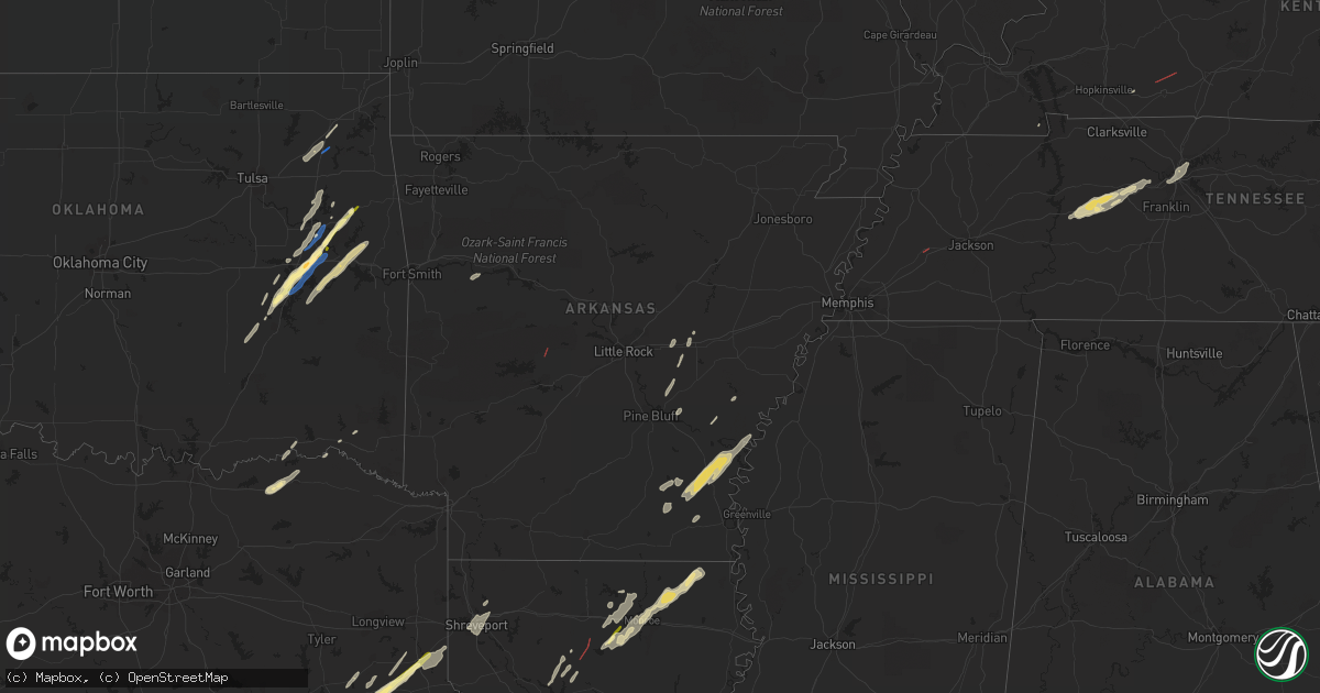
Hail Map in Arkansas on January 2, 2023
Get this storm
January 2 map
$229
one time, instant access
Download today. No call, no setup
Keep the $229
Bought the map and want the full workflow? Apply the entire $229 to a subscription within 7 days. None of it is wasted.
Every map, not just this one
This buys you this map. Subscription and you get every map we run, in the markets you choose from a few cities to whole states to nationwide. Plus real-time alerts the moment a storm fires.
Contact data
Name, contact info, occupancy, even credit band for addresses in the footprint. You go from where it hit to who to call.
Become the source they trust
Unlimited branding weather history reports on demand. You already have the documented answer ready for the property owner, and you are the one who showed up with it.
Property data and RoofTrace estimates
Pull up any address you have got, its value and the exact code rules for that jurisdiction, straight from One Click Code. Then RoofTrace estimates the squares, pitch, and roof value, priced the way you price.
Storm reports in Arkansas
Arkansas
| Date | Description |
|---|---|
| 01/02/20233:00 PM CST | Multiple reports of damage to homes in jessieville along with the jessieville high school football stadium. |
| 01/02/20232:40 PM CST | A local report indicates a tornado near 1 N JESSIEVILLE |
| 01/02/20232:39 PM CST | Prelim report... Nws survey crew has determined a tornado hit the jessieville high school. Further investigation is needed to determine path and wind characteristics. |
| 01/02/20232:38 PM CST | This ef-1 tornado began just to the southwest of jessieville... Causing tree damage around an arkansas forestry commission building. The tornado then quickly moved nort |
| 01/02/202311:48 AM CST | Trees down and some structural damage reported by a trained spotter along murphy loop road. Possible tornado. Time estimated by radar. |
| 01/02/20236:39 AM CST | At 1239 PM CST, a severe thunderstorm was located near Humnoke, or 13 miles west of Stuttgart, moving northeast at 40 mph. HAZARD...60 mph wind gusts and quarter size hail. SOURCE...Radar indicated. IMPACT...Hail damage to vehicles is expected. Expect wind damage to roofs, siding, and trees. Locations impacted include... Carlisle... Humnoke... Parkers Corner... Brummitt... Stuttgart Municipal Airport... Allport... Slovak... Seaton... Tollville... |
| 01/02/20235:58 AM CST | At 1158 AM CST, a severe thunderstorm was located near Gillett, or 19 miles north of Dumas, moving northeast at 40 mph. HAZARD...60 mph wind gusts and quarter size hail. SOURCE...Radar indicated. IMPACT...Hail damage to vehicles is expected. Expect wind damage to roofs, siding, and trees. Locations impacted include... Gillett... St. Charles... De Witt... Indian Bay... Ethel... De Luce... Crocketts Bluff... Lawrenceville... |
| 01/02/20235:38 AM CST | At 1138 PM CST, severe thunderstorms were located along a line extending from near Almyra to near De Witt to 6 miles north of Gillett to near Douglas, moving northeast at 65 mph. HAZARD...60 mph wind gusts. SOURCE...Radar indicated. IMPACT...Expect damage to roofs, siding, and trees. Locations impacted include... Stuttgart... Gould... Gillett... Holly Grove... Almyra... St. Charles... Merrisach Lake... Palmer... Douglas... De Witt... Blackton... Aberdeen... Arkansas Post... De Luce... Almyra Airport... Casscoe... Tichnor... Lodge Corner... Weber... Cross Roads in Monroe County... |
| 01/02/20234:57 AM CST | At 1056 PM CST, severe thunderstorms were located along a line extending from Kedron to near Toledo to Herbine to 8 miles north of Warren, moving northeast at 60 mph. HAZARD...60 mph wind gusts. SOURCE...Radar indicated. IMPACT...Expect damage to roofs, siding, and trees. Locations impacted include... Pine Bluff... Stuttgart... Dumas... Star City... Rison... Altheimer... Gould... Gillett... Humphrey... Grady... Mitchellville... Almyra... Ulm... Whitefield... Plantersville... Little Bayou Meto Park... Woodville... Douglas... Stuttgart Municipal Airport... Herbine... |
| 01/02/20234:52 AM CST | At 1052 PM CST, severe thunderstorms were located along a line extending from near Dobbs Landing to near Holly Grove to near Palmer, moving northeast at 60 mph. HAZARD...60 mph wind gusts. SOURCE...Radar indicated. IMPACT...Expect damage to roofs, siding, and trees. Locations impacted include... Brinkley... Clarendon... Holly Grove... Alfrey... Palmer... Fargo... Blackton... Pine City... Keevil... Monroe... Ragtown... Louisiana Purchase State Park... |
| 01/02/20234:29 AM CST | At 1029 PM CST, severe thunderstorms were located along a line extending from near Dumas to Tillar to 6 miles west of Dermott, moving northeast at 50 mph. HAZARD...60 mph wind gusts and quarter size hail. SOURCE...Radar indicated. IMPACT...Hail damage to vehicles is expected. Expect wind damage to roofs, siding, and trees. Locations impacted include... Dumas... Rosedale... Rohwer... Arkansas City... Mitchellville... Tillar... Watson... Winchester... Yancopin... Omega... Lucca Landing... McGehee... Merrisach Lake... Kelso... Trusten Holder WMA... Mills... Reed... Baxter... Arkansas Post... Garrett Bridge... |
| 01/02/20234:24 AM CST | At 1024 PM CST, a severe thunderstorm was located over Trusten Holder WMA, or 10 miles east of Pea Ridge, moving northeast at 50 mph. HAZARD...60 mph wind gusts. SOURCE...Radar indicated. IMPACT...Expect damage to roofs, siding, and trees. This severe thunderstorm will be near... Gunnison around 1035 PM CST. Deeson around 1045 PM CST.Other locations impacted by this severe thunderstorm includeAlligator, Winstonville, Duncan and Merigold. |
| 01/02/20234:23 AM CST | At 1022 PM CST, severe thunderstorms were located along a line extending from near Gillett to near Trusten Holder WMA to near Kelso, moving northeast at 60 mph. HAZARD...60 mph wind gusts. SOURCE...Radar indicated. IMPACT...Expect damage to roofs, siding, and trees. Locations impacted include... Rohwer... Gillett... St. Charles... Watson... Yancopin... Palmer... Merrisach Lake... Trusten Holder WMA... De Witt... Kelso... Ethel... De Luce... Tichnor... Crocketts Bluff... Ragtown... Indian Bay... Weber... Cross Roads in Monroe County... Lawrenceville... |
| 01/02/20234:20 AM CST | At 1020 PM CST, severe thunderstorms were located along a line extending from 7 miles west of De Witt to near Merrisach Lake to near Lucca Landing, moving northeast at 60 mph. HAZARD...60 mph wind gusts. SOURCE...Radar indicated. IMPACT...Expect damage to roofs, siding, and trees. Locations impacted include... Clarksdale, Marvell, Elaine, White River National Wildlife Refuge, Friars Point, Sherard, Crumrod, Watkins Corner, Lake View, Rena Lara, Mosby Spur, Ferguson, Counts, Wabash, Modoc, Hoop Spur, Westover, Beverly, Turkey Scratch and Ratio. |
| 01/02/20233:10 AM CST | At 910 PM CST, severe thunderstorms were located along a line extending from near Lanark to near Moro Bay State Park to 7 miles southwest of Strong, moving northeast at 55 mph. HAZARD...60 mph wind gusts and penny size hail. SOURCE...Radar indicated. IMPACT...Expect damage to roofs, siding, and trees. Locations impacted include... Monticello... Warren... Star City... Hermitage... Wilmar... Harrell... Ingalls... Plantersville... Moro Bay... Weeks... Herbine... Hilo... Cane Creek State Park... Ladelle... Green Hill... Brandon... Moro Bay State Park... Lanark... Prairie Grove... Banks... |
| 01/02/20231:59 AM CST | At 758 PM CST, a severe thunderstorm was located near Brushy, moving east at 30 mph. HAZARD...60 mph wind gusts and nickel size hail. SOURCE...Radar indicated. IMPACT...Expect damage to roofs, siding, and trees. Locations in or near the path include... Short... Brushy... |
| 01/02/20231:46 AM CST | At 746 PM CST, a severe thunderstorm was located over Bunch, moving northeast at 45 mph. HAZARD...60 mph wind gusts and quarter size hail. SOURCE...Radar indicated. IMPACT...Hail damage to vehicles is expected. Expect wind damage to roofs, siding, and trees. Locations in or near the path include... Stilwell... Bunch... Adair State Park... Maryetta... |
| 01/02/20231:32 AM CST | At 732 PM CST, a severe thunderstorm was located over Swartz, moving northeast at 35 mph. HAZARD...60 mph wind gusts and quarter size hail. SOURCE...Radar indicated. IMPACT...Hail damage to vehicles is expected. Expect wind damage to roofs, siding, and trees. This severe thunderstorm will be near... Bastrop around 755 PM CST. Galion around 815 PM CST.Other locations impacted by this severe thunderstorm include Bonita,Collinston, Mer Rouge and Oak Ridge. |
| 01/02/20231:03 AM CST | At 702 PM CST, severe thunderstorms were located along a line extending from near Fountain Hill to near Portland to 8 miles northwest of Oak Grove, moving northeast at 45 mph. HAZARD...60 mph wind gusts. SOURCE...Radar indicated. IMPACT...Expect damage to roofs, siding, and trees. Locations impacted include... Dermott... Arkansas City... Tillar... Winchester... McGehee... Ladelle... Prairie Grove... Reed... Jerome... Baxter... Enon... Halley... Selma... Masonville... Yukon... Collins... McArthur... Lacey... |
| 01/02/202312:57 AM CST | At 657 PM CST, a severe thunderstorm was located near Hamburg, moving northeast at 55 mph. HAZARD...60 mph wind gusts and nickel size hail. SOURCE...Radar indicated. IMPACT...Expect damage to roofs, siding, and trees. This severe thunderstorm will be near... Hamburg around 700 PM CST. Snyder around 710 PM CST. Dermott around 730 PM CST. |
| 01/01/202311:47 PM CST | At 547 PM CST, severe thunderstorms were located along a line extending from near Farmerville to 8 miles northwest of Claiborne to 10 miles west of Brownsville-Bawcomville to 18 miles southwest of Brownsville-Bawcom to 12 miles east of Jonesboro, moving northeast at 25 mph. HAZARD...60 mph wind gusts and penny size hail. SOURCE...Radar indicated. IMPACT...Expect damage to roofs, siding, and trees. Locations impacted include... Monroe, Claiborne, West Monroe, Swartz, Brownsville-Bawcom, Brownsville-Bawcomville, Farmerville, Richwood, Sterlington, Marion, Chatham, Eros, Downsville, Drew, Fondale, D Arbonne, Vixen, Bosco, Haile and Millhaven. |
| 01/01/20239:55 PM CST | A tree was knocked down and partially fell onto a home. |
| 01/01/20239:45 PM CST | Several roads flooded. |
| 01/01/20239:38 PM CST | At 338 PM CST, severe thunderstorms were located along a line extending from near Petit Jean River WMA to near Plainview in Yell County to 10 miles northwest of Lake Ouachita State Park, moving northeast at 50 mph. HAZARD...60 mph wind gusts and quarter size hail. SOURCE...Radar indicated. IMPACT...Hail damage to vehicles is expected. Expect wind damage to roofs, siding, and trees. Locations impacted include... Russellville... Morrilton... Danville... Perryville... Dardanelle... Atkins... Pottsville... Ola... Oppelo... Perry... Adona... Sequoya Park... Lake Dardanelle State Park... Happy Bend... Hattieville... Jerusalem... Petit Jean River WMA... Mosley... Carden Bottoms... Mt Nebo State Park... |
| 01/01/20239:35 PM CST | Trees down on powerlines in the walker creek community. |
| 01/01/20239:19 PM CST | At 319 PM CST, a severe thunderstorm was located near Corinth, or 8 miles northwest of Murfreesboro, moving northeast at 50 mph. HAZARD...60 mph wind gusts and quarter size hail. SOURCE...Radar indicated. IMPACT...Hail damage to vehicles is expected. Expect wind damage to roofs, siding, and trees. Locations impacted include... Glenwood... Amity... Daisy... Narrows Dam... Daisy State Park... Bear Creek Public Use Area... Salem in Pike County... Welsh... Rosboro... Lodi... Nathan... Hopper... Kirby... Caddo Gap... |
| 01/01/20239:15 PM CST | At 314 PM CST, severe thunderstorms were located along a line extending from near Rosetta to Holman to Knoxville to near Midway in Logan County, moving northeast at 50 mph. HAZARD...60 mph wind gusts and quarter size hail. SOURCE...Radar indicated. IMPACT...Hail damage to vehicles is expected. Expect wind damage to roofs, siding, and trees. Locations impacted include... Lamar... Knoxville... Witts Spring... Dillen... Broomfield... Moore... Solo... Point Peter... Smyrna... Devils Knob... Eula... Bertha... Holman... Rosetta... Lake Dardanelle... Ben Hur... Bass... Fort Douglas... Lutherville... Long Pool Campground... |
| 01/01/20238:40 PM CST | Tree down on a house on agnes rd. |
| 01/01/20238:00 PM CST | At 159 PM CST, severe thunderstorms were located along a line extending from near Winthrop to Foreman to 8 miles west of Richmond to near Maud, moving northeast at 30 mph. HAZARD...60 mph wind gusts and quarter size hail. SOURCE...Radar indicated. IMPACT...Hail damage to vehicles is expected. Expect wind damage to roofs, siding, and trees. Locations impacted include... Ashdown, New Boston, Horatio, Foreman, Hooks, Maud, Red Lick, Lockesburg, Wilton, Winthrop, Ben Lomond, Richmond, Leary, Oak Grove, Silver Ridge, Geneva, Central, Lebanon, Wallace and Arden. |
| 01/01/20237:40 PM CST | Measured at private weather station at lake village municipal airport. |
| 01/01/20237:36 PM CST | 59 mph wind gust from a private weather station near the beouf river. |
| 01/01/20237:24 PM CST | Families trapped in homes due to downed trees and powerlines on w 3rd street and w 2nd street in montrose arkansas. Possible tornado. |
| 01/01/20237:24 PM CST | Families trapped in homes due to downed trees and powerlines on w 3rd street and w 2nd street in montrose arkansas. |
| 01/01/20237:23 PM CST | Tractor trailer overturned... Structure damage on hwy 82 west of montrose arkansas. Possible tornado. |
| 01/01/20237:23 PM CST | Tractor trailer overturned... Structure damage on hwy 82 west of montrose arkansas. |
All States Impacted by Hail Map on January 2, 2023
Cities Impacted by Hail Map on January 2, 2023
- Council Hill, OK
- Checotah, OK
- Henderson, TX
- Wright City, OK
- Des Arc, AR
- Hazen, AR
- Bon Aqua, TN
- Dickson, TN
- Lyles, TN
- Indianola, OK
- Hanna, OK
- Jonesboro, LA
- Fairview, TN
- Burns, TN
- White Bluff, TN
- Kingston Springs, TN
- Calvert, TX
- Cameron, TX
- Jewett, TX
- Buffalo, TX
- Marquez, TX
- Mount Enterprise, TX
- Carthage, TX
- Timpson, TX
- Alto, TX
- Long Branch, TX
- Douglass, TX
- Garrison, TX
- Nacogdoches, TX
- Cushing, TX
- Gary, TX
- Chouteau, OK
- Wagoner, OK
- Muskogee, OK
- Porter, OK
- Montrose, AR
- Downsville, LA
- West Monroe, LA
- Sterlington, LA
- Calhoun, LA
- Choudrant, LA
- Farmerville, LA
- De Witt, AR
- Gillett, AR
- Snow Lake, AR
- Monticello, AR
- Tillar, AR
- McGehee, AR
- Dermott, AR
- Watson, AR
- Eros, LA
- Brookston, TX
- Pryor, OK
- Mcalester, OK
- Hulbert, OK
- Humnoke, AR
- Tucker, AR
- England, AR
- Altheimer, AR
- Wilmar, AR
- Goldonna, LA
- Beckville, TX
- Thorndale, TX
- Jacksonville, TX
- Nashville, TN
- Petty, TX
- Roxton, TX
- Detroit, TX
- Only, TN
- McEwen, TN
- Hurricane Mills, TN
- Nunnelly, TN
- Warner, OK
- Eufaula, OK
- Vian, OK
- Gore, OK
- Porum, OK
- Stigler, OK
- Whitefield, OK
- Webbers Falls, OK
- Quinton, OK
- Adair, OK
- Big Cabin, OK
- Vinita, OK
- Braggs, OK
- Grapeland, TX
- Claremore, OK
- Bossier City, LA
- Shreveport, LA
- Haughton, LA
- Barksdale Afb, LA
- Chatham, LA
- Honey Grove, TX
- Collinston, LA
- Monroe, LA
- Bastrop, LA
- Mer Rouge, LA
- Oak Grove, LA
- Jones, LA
- Oak Ridge, LA
- Dodson, LA
- Winnfield, LA
- Madison, TN
- Old Hickory, TN
- Hendersonville, TN
- Carlisle, AR
- Fort Gibson, OK
- San Augustine, TX
- Rockdale, TX
- Valliant, OK
- Powderly, TX
- Sumner, TX
- Paris, TX
- Benton, LA
- Tahlequah, OK
- Fountain Hill, AR
- New Concord, KY
- Elkton, KY
- Arthur City, TX
- Laneville, TX
- Canadian, OK
- Pomona, KS
- Ottawa, KS
- Williamsburg, KS
- Paris, AR
- Stuart, OK
- Oktaha, OK
- Hugo, OK
- Pegram, TN
- Waverly, TN
- Centerville, TN
- Lobelville, TN
- Chireno, TX
- De Berry, TX
- Rusk, TX
- Saline, LA
- Arkansas City, AR
- Rohwer, AR
- Lake Village, AR
- Portland, AR
- Pleasant Hill, LA
- Coushatta, LA
- Quitman, LA
- Russellville, KY
- Brownsville, TN
- Jessieville, AR
- Homer, LA
- Haynesville, LA


