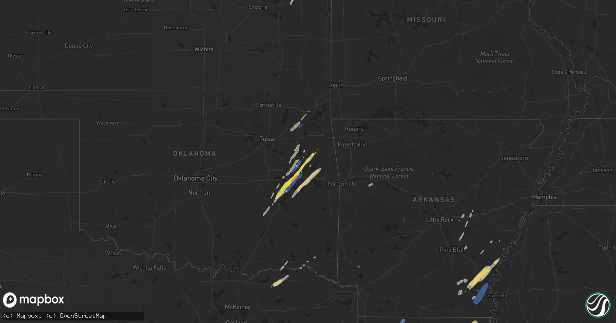
Hail Map on January 2, 2023
Get this storm
January 2 map
$229
one time, instant access
Download today. No call, no setup
Keep the $229
Bought the map and want the full workflow? Apply the entire $229 to a subscription within 7 days. None of it is wasted.
Every map, not just this one
This buys you this map. Subscription and you get every map we run, in the markets you choose from a few cities to whole states to nationwide. Plus real-time alerts the moment a storm fires.
Contact data
Name, contact info, occupancy, even credit band for addresses in the footprint. You go from where it hit to who to call.
Become the source they trust
Unlimited branding weather history reports on demand. You already have the documented answer ready for the property owner, and you are the one who showed up with it.
Property data and RoofTrace estimates
Pull up any address you have got, its value and the exact code rules for that jurisdiction, straight from One Click Code. Then RoofTrace estimates the squares, pitch, and roof value, priced the way you price.
Storm reports
Arkansas
| Date | Description |
|---|---|
| 01/02/20233:00 PM CST | Multiple reports of damage to homes in jessieville along with the jessieville high school football stadium. |
| 01/02/20232:40 PM CST | A local report indicates a tornado near 1 N JESSIEVILLE |
| 01/02/20232:39 PM CST | Prelim report... Nws survey crew has determined a tornado hit the jessieville high school. Further investigation is needed to determine path and wind characteristics. |
| 01/02/20232:38 PM CST | This ef-1 tornado began just to the southwest of jessieville... Causing tree damage around an arkansas forestry commission building. The tornado then quickly moved nort |
| 01/02/202311:48 AM CST | Trees down and some structural damage reported by a trained spotter along murphy loop road. Possible tornado. Time estimated by radar. |
| 01/02/20236:39 AM CST | At 1239 PM CST, a severe thunderstorm was located near Humnoke, or 13 miles west of Stuttgart, moving northeast at 40 mph. HAZARD...60 mph wind gusts and quarter size hail. SOURCE...Radar indicated. IMPACT...Hail damage to vehicles is expected. Expect wind damage to roofs, siding, and trees. Locations impacted include... Carlisle... Humnoke... Parkers Corner... Brummitt... Stuttgart Municipal Airport... Allport... Slovak... Seaton... Tollville... |
| 01/02/20235:58 AM CST | At 1158 AM CST, a severe thunderstorm was located near Gillett, or 19 miles north of Dumas, moving northeast at 40 mph. HAZARD...60 mph wind gusts and quarter size hail. SOURCE...Radar indicated. IMPACT...Hail damage to vehicles is expected. Expect wind damage to roofs, siding, and trees. Locations impacted include... Gillett... St. Charles... De Witt... Indian Bay... Ethel... De Luce... Crocketts Bluff... Lawrenceville... |
| 01/02/20235:38 AM CST | At 1138 PM CST, severe thunderstorms were located along a line extending from near Almyra to near De Witt to 6 miles north of Gillett to near Douglas, moving northeast at 65 mph. HAZARD...60 mph wind gusts. SOURCE...Radar indicated. IMPACT...Expect damage to roofs, siding, and trees. Locations impacted include... Stuttgart... Gould... Gillett... Holly Grove... Almyra... St. Charles... Merrisach Lake... Palmer... Douglas... De Witt... Blackton... Aberdeen... Arkansas Post... De Luce... Almyra Airport... Casscoe... Tichnor... Lodge Corner... Weber... Cross Roads in Monroe County... |
| 01/02/20234:57 AM CST | At 1056 PM CST, severe thunderstorms were located along a line extending from Kedron to near Toledo to Herbine to 8 miles north of Warren, moving northeast at 60 mph. HAZARD...60 mph wind gusts. SOURCE...Radar indicated. IMPACT...Expect damage to roofs, siding, and trees. Locations impacted include... Pine Bluff... Stuttgart... Dumas... Star City... Rison... Altheimer... Gould... Gillett... Humphrey... Grady... Mitchellville... Almyra... Ulm... Whitefield... Plantersville... Little Bayou Meto Park... Woodville... Douglas... Stuttgart Municipal Airport... Herbine... |
| 01/02/20234:52 AM CST | At 1052 PM CST, severe thunderstorms were located along a line extending from near Dobbs Landing to near Holly Grove to near Palmer, moving northeast at 60 mph. HAZARD...60 mph wind gusts. SOURCE...Radar indicated. IMPACT...Expect damage to roofs, siding, and trees. Locations impacted include... Brinkley... Clarendon... Holly Grove... Alfrey... Palmer... Fargo... Blackton... Pine City... Keevil... Monroe... Ragtown... Louisiana Purchase State Park... |
| 01/02/20234:29 AM CST | At 1029 PM CST, severe thunderstorms were located along a line extending from near Dumas to Tillar to 6 miles west of Dermott, moving northeast at 50 mph. HAZARD...60 mph wind gusts and quarter size hail. SOURCE...Radar indicated. IMPACT...Hail damage to vehicles is expected. Expect wind damage to roofs, siding, and trees. Locations impacted include... Dumas... Rosedale... Rohwer... Arkansas City... Mitchellville... Tillar... Watson... Winchester... Yancopin... Omega... Lucca Landing... McGehee... Merrisach Lake... Kelso... Trusten Holder WMA... Mills... Reed... Baxter... Arkansas Post... Garrett Bridge... |
| 01/02/20234:24 AM CST | At 1024 PM CST, a severe thunderstorm was located over Trusten Holder WMA, or 10 miles east of Pea Ridge, moving northeast at 50 mph. HAZARD...60 mph wind gusts. SOURCE...Radar indicated. IMPACT...Expect damage to roofs, siding, and trees. This severe thunderstorm will be near... Gunnison around 1035 PM CST. Deeson around 1045 PM CST.Other locations impacted by this severe thunderstorm includeAlligator, Winstonville, Duncan and Merigold. |
| 01/02/20234:23 AM CST | At 1022 PM CST, severe thunderstorms were located along a line extending from near Gillett to near Trusten Holder WMA to near Kelso, moving northeast at 60 mph. HAZARD...60 mph wind gusts. SOURCE...Radar indicated. IMPACT...Expect damage to roofs, siding, and trees. Locations impacted include... Rohwer... Gillett... St. Charles... Watson... Yancopin... Palmer... Merrisach Lake... Trusten Holder WMA... De Witt... Kelso... Ethel... De Luce... Tichnor... Crocketts Bluff... Ragtown... Indian Bay... Weber... Cross Roads in Monroe County... Lawrenceville... |
| 01/02/20234:20 AM CST | At 1020 PM CST, severe thunderstorms were located along a line extending from 7 miles west of De Witt to near Merrisach Lake to near Lucca Landing, moving northeast at 60 mph. HAZARD...60 mph wind gusts. SOURCE...Radar indicated. IMPACT...Expect damage to roofs, siding, and trees. Locations impacted include... Clarksdale, Marvell, Elaine, White River National Wildlife Refuge, Friars Point, Sherard, Crumrod, Watkins Corner, Lake View, Rena Lara, Mosby Spur, Ferguson, Counts, Wabash, Modoc, Hoop Spur, Westover, Beverly, Turkey Scratch and Ratio. |
| 01/02/20233:10 AM CST | At 910 PM CST, severe thunderstorms were located along a line extending from near Lanark to near Moro Bay State Park to 7 miles southwest of Strong, moving northeast at 55 mph. HAZARD...60 mph wind gusts and penny size hail. SOURCE...Radar indicated. IMPACT...Expect damage to roofs, siding, and trees. Locations impacted include... Monticello... Warren... Star City... Hermitage... Wilmar... Harrell... Ingalls... Plantersville... Moro Bay... Weeks... Herbine... Hilo... Cane Creek State Park... Ladelle... Green Hill... Brandon... Moro Bay State Park... Lanark... Prairie Grove... Banks... |
| 01/02/20231:59 AM CST | At 758 PM CST, a severe thunderstorm was located near Brushy, moving east at 30 mph. HAZARD...60 mph wind gusts and nickel size hail. SOURCE...Radar indicated. IMPACT...Expect damage to roofs, siding, and trees. Locations in or near the path include... Short... Brushy... |
| 01/02/20231:46 AM CST | At 746 PM CST, a severe thunderstorm was located over Bunch, moving northeast at 45 mph. HAZARD...60 mph wind gusts and quarter size hail. SOURCE...Radar indicated. IMPACT...Hail damage to vehicles is expected. Expect wind damage to roofs, siding, and trees. Locations in or near the path include... Stilwell... Bunch... Adair State Park... Maryetta... |
| 01/02/20231:32 AM CST | At 732 PM CST, a severe thunderstorm was located over Swartz, moving northeast at 35 mph. HAZARD...60 mph wind gusts and quarter size hail. SOURCE...Radar indicated. IMPACT...Hail damage to vehicles is expected. Expect wind damage to roofs, siding, and trees. This severe thunderstorm will be near... Bastrop around 755 PM CST. Galion around 815 PM CST.Other locations impacted by this severe thunderstorm include Bonita,Collinston, Mer Rouge and Oak Ridge. |
| 01/02/20231:03 AM CST | At 702 PM CST, severe thunderstorms were located along a line extending from near Fountain Hill to near Portland to 8 miles northwest of Oak Grove, moving northeast at 45 mph. HAZARD...60 mph wind gusts. SOURCE...Radar indicated. IMPACT...Expect damage to roofs, siding, and trees. Locations impacted include... Dermott... Arkansas City... Tillar... Winchester... McGehee... Ladelle... Prairie Grove... Reed... Jerome... Baxter... Enon... Halley... Selma... Masonville... Yukon... Collins... McArthur... Lacey... |
| 01/02/202312:57 AM CST | At 657 PM CST, a severe thunderstorm was located near Hamburg, moving northeast at 55 mph. HAZARD...60 mph wind gusts and nickel size hail. SOURCE...Radar indicated. IMPACT...Expect damage to roofs, siding, and trees. This severe thunderstorm will be near... Hamburg around 700 PM CST. Snyder around 710 PM CST. Dermott around 730 PM CST. |
| 01/01/202311:47 PM CST | At 547 PM CST, severe thunderstorms were located along a line extending from near Farmerville to 8 miles northwest of Claiborne to 10 miles west of Brownsville-Bawcomville to 18 miles southwest of Brownsville-Bawcom to 12 miles east of Jonesboro, moving northeast at 25 mph. HAZARD...60 mph wind gusts and penny size hail. SOURCE...Radar indicated. IMPACT...Expect damage to roofs, siding, and trees. Locations impacted include... Monroe, Claiborne, West Monroe, Swartz, Brownsville-Bawcom, Brownsville-Bawcomville, Farmerville, Richwood, Sterlington, Marion, Chatham, Eros, Downsville, Drew, Fondale, D Arbonne, Vixen, Bosco, Haile and Millhaven. |
| 01/01/20239:55 PM CST | A tree was knocked down and partially fell onto a home. |
| 01/01/20239:45 PM CST | Several roads flooded. |
| 01/01/20239:38 PM CST | At 338 PM CST, severe thunderstorms were located along a line extending from near Petit Jean River WMA to near Plainview in Yell County to 10 miles northwest of Lake Ouachita State Park, moving northeast at 50 mph. HAZARD...60 mph wind gusts and quarter size hail. SOURCE...Radar indicated. IMPACT...Hail damage to vehicles is expected. Expect wind damage to roofs, siding, and trees. Locations impacted include... Russellville... Morrilton... Danville... Perryville... Dardanelle... Atkins... Pottsville... Ola... Oppelo... Perry... Adona... Sequoya Park... Lake Dardanelle State Park... Happy Bend... Hattieville... Jerusalem... Petit Jean River WMA... Mosley... Carden Bottoms... Mt Nebo State Park... |
| 01/01/20239:35 PM CST | Trees down on powerlines in the walker creek community. |
| 01/01/20239:19 PM CST | At 319 PM CST, a severe thunderstorm was located near Corinth, or 8 miles northwest of Murfreesboro, moving northeast at 50 mph. HAZARD...60 mph wind gusts and quarter size hail. SOURCE...Radar indicated. IMPACT...Hail damage to vehicles is expected. Expect wind damage to roofs, siding, and trees. Locations impacted include... Glenwood... Amity... Daisy... Narrows Dam... Daisy State Park... Bear Creek Public Use Area... Salem in Pike County... Welsh... Rosboro... Lodi... Nathan... Hopper... Kirby... Caddo Gap... |
| 01/01/20239:15 PM CST | At 314 PM CST, severe thunderstorms were located along a line extending from near Rosetta to Holman to Knoxville to near Midway in Logan County, moving northeast at 50 mph. HAZARD...60 mph wind gusts and quarter size hail. SOURCE...Radar indicated. IMPACT...Hail damage to vehicles is expected. Expect wind damage to roofs, siding, and trees. Locations impacted include... Lamar... Knoxville... Witts Spring... Dillen... Broomfield... Moore... Solo... Point Peter... Smyrna... Devils Knob... Eula... Bertha... Holman... Rosetta... Lake Dardanelle... Ben Hur... Bass... Fort Douglas... Lutherville... Long Pool Campground... |
| 01/01/20238:40 PM CST | Tree down on a house on agnes rd. |
| 01/01/20238:00 PM CST | At 159 PM CST, severe thunderstorms were located along a line extending from near Winthrop to Foreman to 8 miles west of Richmond to near Maud, moving northeast at 30 mph. HAZARD...60 mph wind gusts and quarter size hail. SOURCE...Radar indicated. IMPACT...Hail damage to vehicles is expected. Expect wind damage to roofs, siding, and trees. Locations impacted include... Ashdown, New Boston, Horatio, Foreman, Hooks, Maud, Red Lick, Lockesburg, Wilton, Winthrop, Ben Lomond, Richmond, Leary, Oak Grove, Silver Ridge, Geneva, Central, Lebanon, Wallace and Arden. |
| 01/01/20237:40 PM CST | Measured at private weather station at lake village municipal airport. |
| 01/01/20237:36 PM CST | 59 mph wind gust from a private weather station near the beouf river. |
| 01/01/20237:24 PM CST | Families trapped in homes due to downed trees and powerlines on w 3rd street and w 2nd street in montrose arkansas. |
| 01/01/20237:24 PM CST | Families trapped in homes due to downed trees and powerlines on w 3rd street and w 2nd street in montrose arkansas. Possible tornado. |
| 01/01/20237:23 PM CST | Tractor trailer overturned... Structure damage on hwy 82 west of montrose arkansas. Possible tornado. |
| 01/01/20237:23 PM CST | Tractor trailer overturned... Structure damage on hwy 82 west of montrose arkansas. |
Illinois
| Date | Description |
|---|---|
| 01/02/20233:03 AM CST | At 903 PM CST, severe thunderstorms were located about 5 miles south of Paducah moving northeast at 45 mph. HAZARD...60 mph wind gusts. SOURCE...Radar indicated. IMPACT...Expect damage to roofs, siding, and trees. Severe thunderstorms will be near... Brookport around 910 PM CST. Reidland around 920 PM CST.Other locations in the path of these severe thunderstorms includeLedbetter.This includes Interstate 24 in Kentucky between Mile Markers 2 and23. |
Kansas
| Date | Description |
|---|---|
| 01/02/20231:31 AM CST | At 731 PM CST, a severe thunderstorm was located near Williamsburg, moving northeast at 50 mph. HAZARD...60 mph wind gusts and quarter size hail. SOURCE...Radar indicated. IMPACT...Hail damage to vehicles is expected. Expect wind damage to roofs, siding, and trees. Locations impacted include... Ottawa and Centropolis. This includes Interstate 35 between mile markers 171 and 181, andbetween mile markers 188 and 189. |
| 01/02/202312:09 AM CST | At 609 PM CST, a severe thunderstorm was located over Afton, moving northeast at 45 mph. HAZARD...60 mph wind gusts and quarter size hail. SOURCE...Radar indicated. IMPACT...Hail damage to vehicles is expected. Expect wind damage to roofs, siding, and trees. Locations in or near the path include... Miami... Vinita... Commerce... Fairland... Afton... Quapaw... Bernice... Ketchum... Wyandotte... Picher... Bernice State Park... Cleora... Narcissa... Ottawa... Peoria... Cardin... Twin Bridges State Park... This includes Interstate 44 between mile markers 284 and 324. |
Tennessee
| Date | Description |
|---|---|
| 01/02/20232:25 AM CST | Corrects previous tornado report from 3 ssw brownsville. A tornado debris signature was detected southwest of brownsville by the knqa 88d radar. Multiple trees down on |
| 01/02/20231:29 AM CST | A local report indicates 60 MPH wind near 1 W MIDTOWN MEMPHIS |
Kentucky
| Date | Description |
|---|---|
| 01/02/20235:01 AM CST | Trees down at 181/latham. Trees also down on dee road. |
| 01/02/20234:30 AM CST | Roof torn off part of house. Several trees uprooted. Damage was along pyle ln near cox mill road. Time estimated by radar. |
| 01/02/20234:25 AM CST | Trees down near herndon. Time estimated by radar. |
| 01/02/20233:30 AM CST | Trees down along princeton road... Time estimated by radar. |
| 01/02/20232:50 AM CST | Trees down on hwy 259 south near mcclure cemetery road. |
| 01/02/20232:00 AM CST | Tree down on sandy creek road. |
Louisiana
| Date | Description |
|---|---|
| 01/02/20235:50 PM CST | One tree reported down along pine grove drive and another nearby along highway 80. |
| 01/02/20234:56 PM CST | Trees down reported along strain allen road. Coincident with radar tornadic debris signature. Likely tornado. |
| 01/02/20234:54 PM CST | Numerous trees down... Including large ones. Likely tornado damage based on tds. |
| 01/02/20234:11 AM CST | Large tree down on the 500 block of college street. Multiple power lines down as well. |
| 01/02/20232:27 AM CST | At 827 PM CST, severe thunderstorms were located along a line extending from near Junction City to 10 miles northwest of Cooley to 9 miles west of Bernice to 10 miles southeast of Homer to near Gibsland to near Dubberly, moving east at 50 mph. HAZARD...60 mph wind gusts and penny size hail. SOURCE...Radar indicated. IMPACT...Expect damage to roofs, siding, and trees. Locations impacted include... Junction City, Bernice, Urbana, Lawson, Cooley, Dubach, Lisbon, Spearsville, Lillie, Antioch, Aurelle, Mount Zion, Taylorville, Summerfield, Hillsboro, Corney Lake, Lockhart, Corinth, Shiloh and Unionville. |
| 01/02/20232:27 AM CST | At 827 PM CST, a severe thunderstorm was located near Galion, or 13 miles east of Bastrop, moving northeast at 30 mph. HAZARD...60 mph wind gusts and quarter size hail. SOURCE...Radar indicated. IMPACT...Hail damage to vehicles is expected. Expect wind damage to roofs, siding, and trees. This severe thunderstorm will be near... Jones around 845 PM CST. Wilmot around 900 PM CST.Other locations impacted by this severe thunderstorm include MerRouge and Bonita. |
| 01/02/20231:56 AM CST | At 756 PM CST, severe thunderstorms were located along a line extending from near Dixie Inn to near Sibley to 8 miles south of Doyline to 13 miles west of Ringgold to 11 miles northeast of Mansfield, moving northeast at 60 mph. HAZARD...60 mph wind gusts and penny size hail. SOURCE...Radar indicated. IMPACT...Expect damage to roofs, siding, and trees. Locations impacted include... Minden, Homer, Haughton, Arcadia, Ringgold, Sibley, Gibsland, Doyline, Dubberly, Dixie Inn, Heflin, Castor, Athens, Bienville, Lisbon, Jamestown, Bryceland, Mount Lebanon, Curtis and Plum Orchard Landing. |
| 01/02/20231:45 AM CST | At 745 PM CST, a severe thunderstorm was located over Richwood, or near Brownsville-Bawcomville, moving northeast at 40 mph. HAZARD...60 mph wind gusts and quarter size hail. SOURCE...Radar indicated. IMPACT...Hail damage to vehicles is expected. Expect wind damage to roofs, siding, and trees. Locations impacted include... Monroe, West Monroe, Brownsville-Bawcomville, Swartz, Brownsville-Bawcom, Richwood, Fondale, Fairbanks, Pine Grove and Millhaven. |
| 01/02/202312:11 AM CST | At 611 PM CST, a severe thunderstorm was located 8 miles northwest of Sterlington, or 15 miles west of Bastrop, moving northeast at 40 mph. HAZARD...60 mph wind gusts. SOURCE...Radar indicated. IMPACT...Expect damage to roofs, siding, and trees. This severe thunderstorm will be near... Beekman around 640 PM CST. Crossett around 650 PM CST. North Crossett around 655 PM CST. Berlin around 700 PM CST.Other locations impacted by this severe thunderstorm include MerRouge, Bonita and Blanchton. |
| 01/01/20239:57 PM CST | At 357 PM CST, a severe thunderstorm was located 8 miles east of Converse, or 16 miles southeast of Mansfield, moving northeast at 30 mph. HAZARD...60 mph wind gusts and nickel size hail. SOURCE...Radar indicated. IMPACT...Expect damage to roofs, siding, and trees. Locations impacted include... Coushatta, Zwolle, Converse, Oak Grove, Pleasant Hill, Martin, Ashland, Noble, Edgefield, Carmel, Lake End, Evelyn, Grand Bayou, Belmont, Hanna, Loggy Bayou, Pelican, Crichton, Rambin and Armistead. |
| 01/01/20239:43 PM CST | At 343 PM CST, a severe thunderstorm was located near Natchitoches, moving northeast at 50 mph. HAZARD...60 mph wind gusts and quarter size hail. SOURCE...Radar indicated. IMPACT...Hail damage to vehicles is expected. Expect wind damage to roofs, siding, and trees. Locations impacted include... Natchitoches, Campti, Provencal, Clarence, Goldonna, Saline, Lucky, Ashland, Robeline, Powhatan, Grand Ecore, Friendship, Black Lake, Chestnut, Clear Lake, Creston and Hagewood. |
| 01/01/20238:30 PM CST | Pictures were sent in from em showing down trees and also a shed destroyed. |
| 01/01/20238:30 PM CST | Power line down near e 4th street. |
| 01/01/20238:15 PM CST | Tree down on pinehill spur near hwy 79. |
| 01/01/20238:05 PM CST | Tree down near heflin and bienville parish line. |
| 01/01/20237:57 PM CST | Tree on power line. |
| 01/01/20237:55 PM CST | Trees down |
| 01/01/20237:55 PM CST | Pergola lifted and relocated 50 feet from original location. |
| 01/01/20237:55 PM CST | Trees down on sligo road. |
| 01/01/20237:32 PM CST | Few buildings with wind damage and trees were reported down. |
| 01/01/20237:00 PM CST | Large hail reported west of monroe. |
| 01/01/20236:45 PM CST | Trees down along lousiana hwy 590 northeast of beekman. |
| 01/01/20236:24 PM CST | Tree down on alabama-landing rd. |
| 01/01/20236:22 PM CST | Transmission towers damaged in the haile community. |
Mississippi
| Date | Description |
|---|---|
| 01/02/20233:42 AM CST | At 941 PM CST, severe thunderstorms were located along a line extending from near Cane Creek State Park to 6 miles southeast of Monticello to Fountain Hill, moving east at 55 mph. HAZARD...60 mph wind gusts and penny size hail. SOURCE...Radar indicated. IMPACT...Expect damage to roofs, siding, and trees. Locations impacted include... Monticello... Dumas... Dermott... Star City... Rohwer... Gould... Arkansas City... Mitchellville... Tillar... Watson... Winchester... Lucca Landing... McGehee... Trusten Holder WMA... Yancopin... Omega... Cane Creek State Park... Mills... Merrisach Lake... Kelso... |
| 01/02/20231:42 AM CST | At 741 PM CST, a severe thunderstorm was located over Dermott, moving northeast at 45 mph. HAZARD...60 mph wind gusts and quarter size hail. SOURCE...Radar indicated. IMPACT...Hail damage to vehicles is expected. Expect wind damage to roofs, siding, and trees. Locations impacted include... Dermott... Rohwer... Arkansas City... Tillar... Watson... Yancopin... Jersey Point... Lucca Landing... McGehee... Kelso... Reed... Masonville... McArthur... Halley... |
Oklahoma
| Date | Description |
|---|---|
| 01/02/20235:55 PM CST | Social media report of half dollar to ping pong ball west of warner. |
| 01/02/20235:49 PM CST | A local report indicates 1.00 inch wind near 4 SSW ONAPA |
| 01/02/20235:40 PM CST | Pryor mesonet located 5 miles s of adair measured 81.4 mph thunderstorm wind gust. |
| 01/02/20235:38 PM CST | Ef-0 tornado snapped tree limbs... Damaged the roofs of several homes... And damaged or destroyed several barns. |
| 01/02/20235:39 AM CST | At 1138 PM CST, a severe thunderstorm was located near Toco, moving northeast at 55 mph. HAZARD...Quarter size hail. SOURCE...Radar indicated. IMPACT...Damage to vehicles is possible. Locations impacted include... Paris, Blossom, Lake Crook, Arthur City, Powderly, Sumner, Lake Gibbons, Pat Mayse Lake, Camp Maxey, Novice, Toco, Sun Valley, Atlas, Forest Chapel, Midcity, Chicota, Globe, Brookston and Faught. |
| 01/02/202312:31 AM CST | At 630 PM CST, a severe thunderstorm was located 4 miles north of Pumpkin Center, moving northeast at 50 mph. HAZARD...60 mph wind gusts and quarter size hail. SOURCE...Radar indicated. IMPACT...Hail damage to vehicles is expected. Expect wind damage to roofs, siding, and trees. Locations in or near the path include... Tahlequah... Kansas... Hulbert... Oaks... Eldon... Leach... Proctor... Scraper... Twin Oaks... Pumpkin Center... |
| 01/02/202312:30 AM CST | At 630 PM CST, a severe thunderstorm was located 3 miles northeast of Blocker, moving northeast at 50 mph. HAZARD...60 mph wind gusts and quarter size hail. SOURCE...Radar indicated. IMPACT...Hail damage to vehicles is expected. Expect wind damage to roofs, siding, and trees. Locations in or near the path include... Eufaula... Stigler... Warner... Quinton... Porum... Webbers Falls... Crowder... Whitefield... Canadian... Tamaha... Briartown... Blocker... Arrowhead State Park... Enterprise... Kanima... Featherston... Lewisville... This includes Interstate 40 in Oklahoma between mile markers 270 and287. |
| 01/02/202312:01 AM CST | At 600 PM CST, a severe thunderstorm was located 7 miles southwest of Warner, moving northeast at 40 mph. HAZARD...60 mph wind gusts and quarter size hail. SOURCE...Radar indicated. IMPACT...Hail damage to vehicles is expected. Expect wind damage to roofs, siding, and trees. Locations in or near the path include... Checotah... Warner... Gore... Webbers Falls... Oktaha... Braggs... Rentiesville... Greenleaf State Park... Pumpkin Center... Lake Tenkiller State Park... Keefeton... Box...This includes Interstate 40 in Oklahoma between mile markers 262 and287. |
| 01/01/202311:36 PM CST | At 536 PM CST, a severe thunderstorm was located 5 miles northwest of Keefeton, moving northeast at 35 mph. HAZARD...60 mph wind gusts and nickel size hail. SOURCE...Radar indicated. IMPACT...Expect damage to roofs, siding, and trees. Locations in or near the path include... Muskogee... Tahlequah... Fort Gibson... Okay... Hulbert... Braggs... Sequoyah State Park... Pumpkin Center... Summit... Lost City... |
| 01/01/202311:05 PM CST | At 505 PM CST, severe thunderstorms were located along a line extending from 2 miles southwest of Foyil to near Taiwah to 5 miles northeast of Oneta, moving northeast at 35 mph. HAZARD...60 mph wind gusts and nickel size hail. SOURCE...Radar indicated. IMPACT...Expect damage to roofs, siding, and trees. Locations in or near the path include... Claremore... Vinita... Pryor... Pryor Creek... Chouteau... Chelsea... Inola... Adair... Foyil... Big Cabin... White Oak... Sportsmen Acres Community... Taiwah... Tiawah... Mazie... Murphy... Bushyhead... This includes Interstate 44 between mile markers 246 and 282. |
| 01/01/202311:04 PM CST | At 503 PM CST, a severe thunderstorm was located 4 miles north of Haywood, moving northeast at 40 mph. HAZARD...60 mph wind gusts and quarter size hail. SOURCE...Radar indicated. IMPACT...Hail damage to vehicles is expected. Expect wind damage to roofs, siding, and trees. Locations in or near the path include... Mcalester... Eufaula... Crowder... Canadian... Indianola... Hanna... Stidham... Raiford... Haywood... Vivian... Arrowhead State Park... Scipio... Arpelar... This includes Interstate 40 in Oklahoma near mile marker 249. |
| 01/01/20236:39 PM CST | Report from amateur radio of trees down and hail ranging from peas to quarter size 1 mile north of woodall school. |
| 01/01/20236:30 PM CST | Roof blown off a barn and into side of a single family home in keefeton. No injuries. |
Missouri
| Date | Description |
|---|---|
| 01/02/202312:36 AM CST | At 636 PM CST, a severe thunderstorm was located near Piggott, moving northeast at 40 mph. HAZARD...60 mph wind gusts. SOURCE...Radar indicated. IMPACT...Expect damage to roofs, siding, and trees. Locations impacted include... Malden, Piggott, Campbell, Clarkton, Holcomb, St. Francis, Greenway, Saint Francis, Rhyne, Providence, Morris State Park, Baird, McGuires and Townley. |
Texas
| Date | Description |
|---|---|
| 01/02/20233:10 AM CST | Quarter size hail reported in carthage. |
| 01/02/20232:15 AM CST | Ping pong ball size hail reported just south of cushing near the intersection of fm 225 and fm 343. |
| 01/01/20238:07 PM CST | At 206 PM CST, a severe thunderstorm was located over Ebenezer, moving north at 35 mph. HAZARD...60 mph wind gusts. SOURCE...Radar indicated. IMPACT...Expect damage to roofs, siding, and trees. Locations impacted include... Pineland, Bronson and Chinaquapin. |
| 01/01/20237:00 PM CST | At 1259 PM CST, a severe thunderstorm was located 10 miles east of Raymond Gary State Park, or 24 miles east of Hugo, moving northeast at 50 mph. HAZARD...60 mph wind gusts and quarter size hail. SOURCE...Radar indicated. IMPACT...Hail damage to vehicles is expected. Expect wind damage to roofs, siding, and trees. Locations impacted include... Wright City, Valliant, Millerton, Redland, Farmers Hill, Glover, Slim, Bethel, Battiest, Mount Herman, Sherwood and Golden. |
Cities Impacted by Hail Map on January 2, 2023
- Council Hill, OK
- Checotah, OK
- Henderson, TX
- Wright City, OK
- Des Arc, AR
- Hazen, AR
- Bon Aqua, TN
- Dickson, TN
- Lyles, TN
- Indianola, OK
- Hanna, OK
- Jonesboro, LA
- Fairview, TN
- Burns, TN
- White Bluff, TN
- Kingston Springs, TN
- Calvert, TX
- Cameron, TX
- Jewett, TX
- Buffalo, TX
- Marquez, TX
- Mount Enterprise, TX
- Carthage, TX
- Timpson, TX
- Alto, TX
- Long Branch, TX
- Douglass, TX
- Garrison, TX
- Nacogdoches, TX
- Cushing, TX
- Gary, TX
- Chouteau, OK
- Wagoner, OK
- Muskogee, OK
- Porter, OK
- Montrose, AR
- Downsville, LA
- West Monroe, LA
- Sterlington, LA
- Calhoun, LA
- Choudrant, LA
- Farmerville, LA
- De Witt, AR
- Gillett, AR
- Snow Lake, AR
- Monticello, AR
- Tillar, AR
- McGehee, AR
- Dermott, AR
- Watson, AR
- Eros, LA
- Brookston, TX
- Pryor, OK
- Mcalester, OK
- Hulbert, OK
- Humnoke, AR
- Tucker, AR
- England, AR
- Altheimer, AR
- Wilmar, AR
- Goldonna, LA
- Beckville, TX
- Thorndale, TX
- Jacksonville, TX
- Nashville, TN
- Petty, TX
- Roxton, TX
- Detroit, TX
- Only, TN
- McEwen, TN
- Hurricane Mills, TN
- Nunnelly, TN
- Warner, OK
- Eufaula, OK
- Vian, OK
- Gore, OK
- Porum, OK
- Stigler, OK
- Whitefield, OK
- Webbers Falls, OK
- Quinton, OK
- Adair, OK
- Big Cabin, OK
- Vinita, OK
- Braggs, OK
- Grapeland, TX
- Claremore, OK
- Bossier City, LA
- Shreveport, LA
- Haughton, LA
- Barksdale Afb, LA
- Chatham, LA
- Honey Grove, TX
- Collinston, LA
- Monroe, LA
- Bastrop, LA
- Mer Rouge, LA
- Oak Grove, LA
- Jones, LA
- Oak Ridge, LA
- Dodson, LA
- Winnfield, LA
- Madison, TN
- Old Hickory, TN
- Hendersonville, TN
- Carlisle, AR
- Fort Gibson, OK
- San Augustine, TX
- Rockdale, TX
- Valliant, OK
- Powderly, TX
- Sumner, TX
- Paris, TX
- Benton, LA
- Tahlequah, OK
- Fountain Hill, AR
- New Concord, KY
- Elkton, KY
- Arthur City, TX
- Laneville, TX
- Canadian, OK
- Pomona, KS
- Ottawa, KS
- Williamsburg, KS
- Paris, AR
- Stuart, OK
- Oktaha, OK
- Hugo, OK
- Pegram, TN
- Waverly, TN
- Centerville, TN
- Lobelville, TN
- Chireno, TX
- De Berry, TX
- Rusk, TX
- Saline, LA
- Arkansas City, AR
- Rohwer, AR
- Lake Village, AR
- Portland, AR
- Pleasant Hill, LA
- Coushatta, LA
- Quitman, LA
- Russellville, KY
- Brownsville, TN
- Jessieville, AR
- Homer, LA
- Haynesville, LA