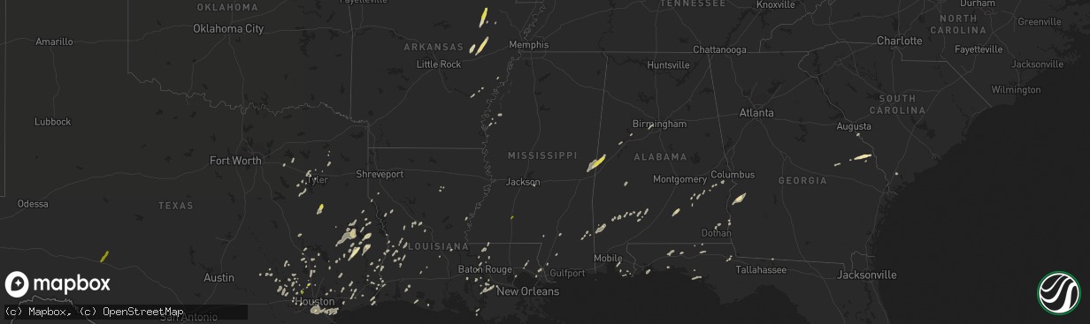
Hail Map in Mississippi on January 2, 2017
The weather event in Mississippi on January 2, 2017 includes Hail map. 8 states and 278 cities were impacted and suffered possible damage. The total estimated number of properties impacted is 361.
Want more than just the map?
Turn this storm into a full workflow.
- Owner + property data so you know who to knock
- OnDemand branded weather history reports to win the "did we even have hail?" argument
- RoofTrace estimate so reps stop guessing numbers at the door
Bought this map? Upgrade within 7 days and we'll credit the $230. (10-15 min setup call)
Hail
361
Estimated number of impacted properties by a 1.00" hail or larger0
Estimated number of impacted properties by a 1.75" hail or larger0
Estimated number of impacted properties by a 2.50" hail or largerStorm reports in Mississippi
Mississippi
| Date | Description |
|---|---|
| 01/02/20173:45 PM CST | Tree across road on hwy 39 |
| 01/02/20173:33 PM CST | Tree on a home in meridian |
| 01/02/20173:30 PM CST | Tree on a house |
| 01/02/20173:30 PM CST | County em reports many trees and powerlines down across wayne county. Time estimated via radar |
| 01/02/20173:28 PM CST | Nws storm survey found an ef0 tornado with max winds of 75mph. Max width of 75 yards. Path length of 1.5 miles. This brief tornado touched down along meehan-savoy road |
| 01/02/20173:26 PM CST | Trees and power lines down on memorial church rd. Time estimated via radar. |
| 01/02/20173:22 PM CST | Trees and lines down at us 45 and ms 145 |
| 01/02/20173:21 PM CST | Trees down on i-59...possible tornado. |
| 01/02/20173:21 PM CST | Tree on a vehicle along cr 1681 |
| 01/02/20173:15 PM CST | Trees down on hwy 513...possible tornado |
| 01/02/20173:12 PM CST | Tree down across old river rd and kennedy rd |
| 01/02/20173:10 PM CST | Trees down on line rd |
| 01/02/20173:10 PM CST | Several limbs were down |
| 01/02/20173:07 PM CST | Tree down across us 49 at dewitt carter rd |
| 01/02/20173:06 PM CST | Several homes damaged |
| 01/02/20173:05 PM CST | Several trees down on shady grove moss rd |
| 01/02/20173:03 PM CST | Numerous trees and powerlines down |
| 01/02/20173:00 PM CST | Trees down on lake como road |
| 01/02/20173:00 PM CST | A large tree was snapped on pine grove road. |
| 01/02/20173:00 PM CST | Tree down across pig town rd |
| 01/02/20172:59 PM CST | Several trees down across parts of interstate 59. Tree damage about a quarter mile along interstate 59 reported by storm chaser. |
| 01/02/20172:59 PM CST | Numerous trees and powerlines down down on app slade rd. Several homes were damaged. |
| 01/02/20172:59 PM CST | Several trees downed along baker rd |
| 01/02/20172:56 PM CST | Trees down on i-59 near mile marker 50 |
| 01/02/20172:55 PM CST | Trees downed across old highway 11 |
| 01/02/20172:53 PM CST | Trees down along max white rd |
| 01/02/20172:53 PM CST | Traveled east and caused damage to trees and structures. Path length 5.61 miles. Max width 150 yards. Peak wind 107 mph. |
| 01/02/20172:52 PM CST | Nws survey found an ef1 tornado with max winds of 105mph. Max width of 225 yards. Path length of 8.4 miles. This tornado touched down near corinth cutoff road and conti |
| 01/02/20172:50 PM CST | Mutiple trees down on columbia purvis rd. Tree on home at 1933 columbia purvis rd. |
| 01/02/20172:50 PM CST | Numerous trees down on max white road |
| 01/02/20172:50 PM CST | Numerous trees and powerlines down. Tree on home at 1024 county rd 17. |
| 01/02/20172:48 PM CST | Numerous trees and powerlines down. Tree on home at 21 north 1st street in bay springs. |
| 01/02/20172:43 PM CST | Nws survey found an ef1 tornado with max winds of 105mph. Max width of 275 yards. Path length of 3.9 miles. This tornado touched down near county road 33b and continued |
| 01/02/20172:42 PM CST | Minor damage to a school along ms hwy 13 |
| 01/02/20172:31 PM CST | Trees downed blocking us 49 south of collins |
| 01/02/20172:30 PM CST | Multiple trees downed along a mile long stretch of highway 37 in far northeast covington county. Damage indicators and radar suggest straight line winds. |
| 01/02/20172:28 PM CST | Power lines and power poles downed along ms hwy 13 at old river rd |
| 01/02/20172:25 PM CST | Trees down on 10 mile creek road including one on a home. Power line down as well. |
| 01/02/20172:24 PM CST | Multiple trees down along ms hwy 532 |
| 01/02/20172:21 PM CST | Traveled northeast and caused damage to structures and trees. Path length 4.23 miles. Max width 300 yards. Peak wind 113 mph. |
| 01/02/20172:21 PM CST | A bunch of large metal chicken houses were destroyed. Debris lofted into trees. Several trees and power lines down. |
| 01/02/20172:20 PM CST | Several trees were blown down and there was damage to a building along highway 48. |
| 01/02/20172:18 PM CST | Tree down at ms 35 south of mount olive |
| 01/02/20172:10 PM CST | Large tree downed on mcdowell rd in jackson |
| 01/02/20172:08 PM CST | Trees down across hwy 469 near foster rd. |
| 01/02/20172:08 PM CST | Homes and chicken houses damaged... Trees blocking merritt welch road... Highway13 and highway 43 |
| 01/02/20172:06 PM CST | Several trees downed...roof damage to home...mobile flipped on side and firework stand blown over reported by storm spotter. |
| 01/02/20172:04 PM CST | Trees and power lines down |
| 01/02/20172:02 PM CST | Traveled northeast causing damage to trees and structures including a chicken farm. Path length 9.47 miles. Max width 400 yards. Peak wind 110 mph. |
| 01/02/20172:02 PM CST | Trees and power lines down |
| 01/02/20172:00 PM CST | A weak tornado...ef1...touched down along and just north of highway 48 west of tylertown. Some large trees were uprooted and snapped. Power lines were damaged by the fa |
| 01/02/20171:55 PM CST | Trees and power lines down across the south portion of the county. |
| 01/02/20171:55 PM CST | A weak tornado...ef1...touched down along an intermittent path in southeast pike county from around emerald road south of highway 48 to love creek road just north of hi |
| 01/02/20171:46 PM CST | Trees and power lines down across the west part of the county. |
| 01/02/20171:45 PM CST | A tree down on hwy 467 |
| 01/02/20171:45 PM CST | Ham operator reported numerous trees down and roof blown off structure along lang rd. |
| 01/02/20171:43 PM CST | Ham operator reported a tree down across highway 51 in chatawa. |
| 01/02/20171:42 PM CST | Tree uprooted |
| 01/02/20171:42 PM CST | Tree down on interstate 55 reported by media. |
| 01/02/20171:42 PM CST | Trees and lines down along hwy 61 north |
| 01/02/20171:32 PM CST | A tree was snapped |
| 01/02/20171:30 PM CST | Tree split a mobile home |
| 01/02/20171:30 PM CST | Shed and two barns destroyed on monticello rd |
| 01/02/20171:30 PM CST | Numerous trees down with power outages |
| 01/02/20171:30 PM CST | Tree on house near chippewa and cleveland |
| 01/02/20171:30 PM CST | A local report indicates 1.00 inch wind near 1 W BROOKHAVEN |
| 01/02/20171:29 PM CST | Several homes damaged in thompson community. Possible tornado touch down reported by emergency management. |
| 01/02/20171:26 PM CST | Top blown off mobile home trees and powerlines down... Chicken house damaged |
| 01/02/20171:25 PM CST | Top blown off mobile home trees and powerlines down... Chicken house damaged |
| 01/02/20171:25 PM CST | Barn destroyed on hunsucker lane |
| 01/02/20171:25 PM CST | Sweetwater united methodist church was pushed off of the foundation and the backwall was blown out. |
| 01/02/20171:24 PM CST | Trees down and damage to homes along watson rd |
| 01/02/20171:23 PM CST | Sweetwater united methodist church was pushed off of the foundation and the backwall was blown out. |
| 01/02/20171:21 PM CST | Traveled northeast into copiah county causing damage to trees and structures. Path length 6.81 miles. Max width 300 yards. Peak wind 110 mph. |
| 01/02/20171:18 PM CST | Trees and lines down along hwy 61 south. |
| 01/02/20171:18 PM CST | Trees down across the trace |
| 01/02/20171:14 PM CST | A few trees down along with a power line and power pole. |
| 01/02/20171:14 PM CST | Traveled northeast and crossed ms highway 547. Path length 5.62 miles. Max width 200 yards. Peak wind 95 mph. |
| 01/02/20171:14 PM CST | Several trees downed along ms hwy 547 at white hall rd. Possible tornado. |
| 01/02/20171:06 PM CST | A couple trees down in bude and meadville |
| 01/02/20171:02 PM CST | Moved northeast and crossed ms highway 28. Damaged only trees. Path length 3.95 miles. Max width 250 yards. |
| 01/02/201712:53 PM CST | A large tree was uprooted |
| 01/02/201712:45 PM CST | Numerous trees down across the county |
| 01/02/201712:25 PM CST | Trees were down across liberty and ellislie plantation roads. |
| 01/02/201712:25 PM CST | A tree was down blocking both southbound lanes of highway 61. |
| 01/02/201710:47 AM CST | Tree fell on a truck near the prison in greene county. Time estimated via radar. |
| 01/01/20176:00 PM CST | Trees down and power lines down on marvin williams road |
All States Impacted by Hail Map on January 2, 2017
Cities Impacted by Hail Map on January 2, 2017
- Corrigan, TX
- Sylvania, GA
- Jasper, TX
- Tuckerman, AR
- Newport, AR
- Swifton, AR
- Woodville, TX
- Colmesneil, TX
- Epes, AL
- Gainesville, AL
- Emelle, AL
- Porterville, MS
- Lauderdale, MS
- Houston, TX
- Deridder, LA
- Chandler, TX
- Terrell, TX
- Kaufman, TX
- Wills Point, TX
- Cotton Plant, AR
- McCrory, AR
- Leesville, LA
- Augusta, GA
- Vinton, LA
- Ville Platte, LA
- Hurtsboro, AL
- Deer Park, AL
- Dayton, TX
- Cypress, TX
- Poplarville, MS
- Perkinston, MS
- Columbia, MS
- De Witt, AR
- Livingston, TX
- Conroe, TX
- Tomball, TX
- Magnolia, TX
- Center, TX
- Katy, TX
- Hockley, TX
- Columbia, LA
- Call, TX
- Franklin, AL
- Brenham, TX
- Stuttgart, AR
- Athens, TX
- Des Arc, AR
- Augusta, AR
- Griffithville, AR
- Joaquin, TX
- Port Arthur, TX
- Huntsville, TX
- New Waverly, TX
- Pearl River, LA
- Rocky Ford, GA
- Millen, GA
- Gillett, AR
- Livingston, AL
- Morrow, LA
- Plaucheville, LA
- Monroeville, AL
- Belle Rose, LA
- Donaldsonville, LA
- Baker, LA
- Brookshire, TX
- Flatwoods, LA
- Lena, LA
- Cuthbert, GA
- Lumpkin, GA
- Richland, GA
- Jackson, SC
- Anderson, TX
- Port Allen, LA
- Seale, AL
- Hatchechubbee, AL
- Spring, TX
- Fisher, AR
- Weiner, AR
- Jonesboro, AR
- Wynne, AR
- Hickory Ridge, AR
- Bronson, TX
- Kirbyville, TX
- Singer, LA
- Waller, TX
- Navasota, TX
- Hempstead, TX
- Ponchatoula, LA
- San Augustine, TX
- Beaumont, TX
- Devers, TX
- Tyler, TX
- Basile, LA
- Eunice, LA
- Seabrook, TX
- Dickinson, TX
- Webster, TX
- Bacliff, TX
- Kemah, TX
- League City, TX
- Shepherd, TX
- McIntosh, AL
- Fruitdale, AL
- Vinegar Bend, AL
- Tibbie, AL
- Wagarville, AL
- Vidor, TX
- Grove Hill, AL
- Jackson, AL
- Pittsburg, TX
- Gilmer, TX
- Bush, LA
- Whatley, AL
- Jennings, LA
- Plantersville, TX
- Baton Rouge, LA
- Orange, TX
- Grosse Tete, LA
- Brookeland, TX
- Pineland, TX
- Broaddus, TX
- Moscow, TX
- Grand Cane, LA
- Willis, TX
- Rusk, TX
- Covington, LA
- Huntington, TX
- Lufkin, TX
- Zavalla, TX
- Etoile, TX
- Diboll, TX
- Chappell Hill, TX
- Buna, TX
- Shorterville, AL
- Richmond, TX
- Bonifay, FL
- Provencal, LA
- Headland, AL
- Newville, AL
- Pearland, TX
- Manvel, TX
- Tuscaloosa, AL
- Peterman, AL
- Blakely, GA
- Fort Polk, LA
- Grayson, LA
- Ragley, LA
- Longville, LA
- Ridgeland, SC
- Brandon, MS
- Westville, FL
- Liberty, TX
- Cleveland, TX
- Grand Chenier, LA
- Winona, TX
- Greenville, MS
- Foley, AL
- Magnolia Springs, AL
- Hattiesburg, MS
- Chester, TX
- Leakesville, MS
- Alvin, TX
- Friendswood, TX
- Fresno, TX
- Rosharon, TX
- Brantley, AL
- Rutledge, AL
- Luverne, AL
- Dolomite, AL
- Bessemer, AL
- Pleasant Grove, AL
- Jackson, LA
- Ethel, LA
- Wilson, LA
- Picayune, MS
- Lindale, TX
- Loxley, AL
- Daphne, AL
- Thomaston, AL
- Union Springs, AL
- Logansport, LA
- Swainsboro, GA
- Centerville, TX
- Crockett, TX
- Somerville, TX
- Winnie, TX
- Newton, TX
- Elberta, AL
- Defuniak Springs, FL
- Grand Ridge, FL
- Marianna, FL
- Fairhope, AL
- Troy, AL
- Plaquemine, LA
- Paulina, LA
- Convent, LA
- Boyle, MS
- Cleveland, MS
- Mora, LA
- Lacassine, LA
- Bell City, LA
- Crosby, TX
- Kaplan, LA
- White Castle, LA
- Slidell, LA
- Meridian, MS
- Boligee, AL
- Scooba, MS
- Aliceville, AL
- Amagon, AR
- Gulf Shores, AL
- Lexa, AR
- Vidalia, LA
- Sour Lake, TX
- Palestine, TX
- Larue, TX
- Elmer, LA
- Boyce, LA
- Many, LA
- Pierre Part, LA
- Morgan City, LA
- Zwolle, LA
- Evergreen, AL
- Brownsboro, TX
- Murchison, TX
- Patterson, LA
- Anahuac, TX
- Bon Wier, TX
- Merryville, LA
- Starks, LA
- Monticello, FL
- Geismar, LA
- Bellville, TX
- Sabine Pass, TX
- Cameron, LA
- Bridge City, TX
- Pointblank, TX
- Shaw, MS
- Leland, MS
- Gulf Breeze, FL
- Ben Wheeler, TX
- Ebro, FL
- Morris, GA
- Norwood, LA
- Sealy, TX
- Saint Stephens, AL
- Leroy, AL
- Pitkin, LA
- Evans, LA
- Buhl, AL
- Ralph, AL
- Midway, AL
- Saint James, LA
- Plattenville, LA
- Napoleonville, LA
- Big Sandy, TX
- Goodrich, TX
- Chireno, TX
- Panama City Beach, FL
- Burton, TX
- Fort Walton Beach, FL
- Shalimar, FL
- Eglin Afb, FL
- Lone Star, TX
- Dothan, AL
- Benoit, MS
- Burkeville, TX
- Pride, LA
- Zachary, LA
- Slaughter, LA
- Crestview, FL
- Warren, TX
- Point, TX
- Edgewood, TX
- Brookhaven, MS
- Bogue Chitto, MS
- Sonora, TX
- Eldorado, TX


