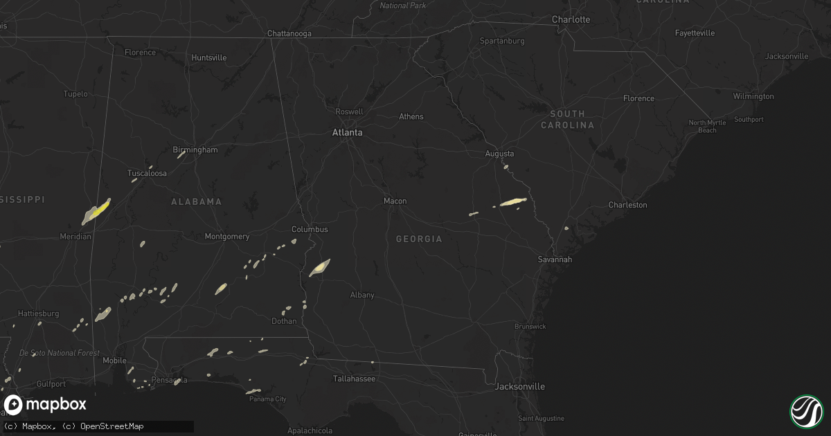
Hail Map in Georgia on January 2, 2017
Get this storm
January 2 map
$229
one time, instant access
Download today. No call, no setup
Keep the $229
Bought the map and want the full workflow? Apply the entire $229 to a subscription within 7 days. None of it is wasted.
Every map, not just this one
This buys you this map. Subscription and you get every map we run, in the markets you choose from a few cities to whole states to nationwide. Plus real-time alerts the moment a storm fires.
Contact data
Name, contact info, occupancy, even credit band for addresses in the footprint. You go from where it hit to who to call.
Become the source they trust
Unlimited branding weather history reports on demand. You already have the documented answer ready for the property owner, and you are the one who showed up with it.
Property data and RoofTrace estimates
Pull up any address you have got, its value and the exact code rules for that jurisdiction, straight from One Click Code. Then RoofTrace estimates the squares, pitch, and roof value, priced the way you price.
Storm reports in Georgia
Georgia
| Date | Description |
|---|---|
| 01/02/20175:30 PM CST | Tree down at fort benning access point 2... Blocking 1 lane of traffic |
| 01/02/20175:25 PM CST | Reports of a downed tree blocking the roadway on vibbert ave by olsen hall |
| 01/02/20175:20 PM CST | Emergency manager reports trees down on wilson pond rd about 3 miles nw of downtown preston along with structural damage to metal buildings... And shingles blown off of |
| 01/02/20175:20 PM CST | 911 call center received report of trees down at the intersection of hwy 41 and centerpoint rd... In between weston and preston |
| 01/02/20174:47 PM CST | Emergency manager received reports of several destroyed chicken coops... Several chicken coops with major damage... And several trees down on freeman road in troutman. |
| 01/02/20174:33 PM CST | A large tree crushed a mobile home in the boscom community. Social media images show extensive damage to the home. Time estimated based on radar. Reported relayed by lo |
| 01/02/20174:26 PM CST | Screven county 911 reported trees down at intersection of winchester rd and sunnyside rd. Separate report received of hail damage to a passing vehicle but hail size was |
| 01/01/201711:55 PM CST | 4 trees reported down along old louisville rd. Near montgomery county border. Time of event estimated from radar |
| 01/01/201711:50 PM CST | 4 trees down around paradice circle... Time of event estimated from radar |
| 01/01/201711:48 PM CST | Candler county warning point reported tree across roadway at 121 forehand lane. |
| 01/01/201711:36 PM CST | Tree down near intersection of hwy 199 and hwy 221... Time of event estimated from radar data. |
| 01/01/201711:36 PM CST | Several reports of trees down on the west side and north side of the county. Details still coming in |
| 01/01/201711:21 PM CST | Trees down in cedar grove area... Time of event estimated from radar. |
| 01/01/201710:40 PM CST | In the south corner of whatley vineyard... 20 to 25 trees were uprooted and a few were snapped. |
| 01/01/201710:35 PM CST | At the intersection of el bethel church road and highway 280... A house was reported with roof shingles blown off. There was also a farm shed that collapsed in the stor |
| 01/01/201710:30 PM CST | Several trees down across hwy 129... South of abbeville. Location and time estimated from radar. |
| 01/01/201710:23 PM CST | Tree down on a home at 32 reeves street in rhine |
| 01/01/201710:20 PM CST | Report of trees down along livingston road |
| 01/01/201710:15 PM CST | Emergency manager reported numerous trees down along hwy 233 south of rochelle. Also...one power pole was snapped and several were leaning. Time estimated from radar. |
| 01/01/201710:15 PM CST | Emergency manager reported numerous trees down along hwy 233 south of rochelle. Also...one power pole was snapped and several were leaning. Time estimated from radar. |
| 01/01/201710:13 PM CST | 1 tree reported down in ben hill county |
| 01/01/201710:05 PM CST | Trees down on shady lane |
| 01/01/201710:04 PM CST | Trees down on scott road |
| 01/01/201710:03 PM CST | Trees down on the north end of freeman road |
| 01/01/201710:00 PM CST | Tree down into a house |
| 01/01/201710:00 PM CST | Trees down on john pate road |
| 01/01/201710:00 PM CST | Trees down on amboy farms road |
| 01/01/20179:56 PM CST | Trees down on kendrick road |
| 01/01/20179:56 PM CST | Trees down on highway 159 |
| 01/01/20179:56 PM CST | Trees down on hopewell road |
| 01/01/20179:56 PM CST | Trees down on ireland road |
| 01/01/20179:55 PM CST | Numerous trees and power lines down in turner county |
| 01/01/20179:55 PM CST | Preliminary from crisp county. 1 vehicle totaled...2 damaged from falling trees. One home has moderate damage. One home has minimal. Several barns and storage buidlings |
| 01/01/20179:55 PM CST | Preliminary from crisp county. 1 vehicle totaled...2 damaged from falling trees. One home has moderate damage. One home has minimal. Several barns and storage buidlings |
| 01/01/20179:54 PM CST | Trees down on alberson road |
| 01/01/20179:52 PM CST | Trees down on warwick highway |
| 01/01/20179:52 PM CST | *** 1 fatal *** straight line winds destroyed a small unsecured building killing the occupant. Winds estimated around 80 mph. |
| 01/01/20179:50 PM CST | Roof to a screened in porch ripped off along highway 313 north |
| 01/01/20179:49 PM CST | Tree on a power line on highway 33 south of gleaton road |
| 01/01/20179:46 PM CST | Numerous trees and power lines down across colquitt county |
| 01/01/20179:46 PM CST | Trees down on highway 32 |
| 01/01/20179:45 PM CST | Trees down on jodie hobby road |
| 01/01/20179:45 PM CST | Tree across home with power lines down on walter murphy road |
| 01/01/20179:45 PM CST | Trees down on eric alred road |
| 01/01/20179:45 PM CST | Roof damage to several large commercial chicken houses and large barns |
| 01/01/20179:45 PM CST | Roof damage...pool damage...outbuilding damage...and vehicle damage on highway 32 east |
| 01/01/20179:45 PM CST | Trees down on abrams road |
| 01/01/20179:45 PM CST | Windows blown out of barn and roof off an outbuilding on highway 32 east. |
| 01/01/20179:44 PM CST | Trees down and roof damage on howard drive |
| 01/01/20179:43 PM CST | Roof damage along highway 313 north |
| 01/01/20179:43 PM CST | Numerous trees down on highway 313 |
| 01/01/20179:43 PM CST | Trees down on red oak road |
| 01/01/20179:39 PM CST | Damage to a shop along highway 313 north |
| 01/01/20179:38 PM CST | Trees down on crowe lane |
| 01/01/20179:37 PM CST | Structural damage reported at the charity grove baptist church |
| 01/01/20179:37 PM CST | Roof off a farm house along cleo boyd road |
| 01/01/20179:37 PM CST | Trees and power lines down on ausby road |
| 01/01/20179:37 PM CST | Trees down on harris road |
| 01/01/20179:37 PM CST | Trees down on fowler road |
| 01/01/20179:37 PM CST | Trees and power lines down on blue springs road from church to jewel crowe road |
| 01/01/20179:35 PM CST | Trees down and barn damaged along massey airport road |
| 01/01/20179:35 PM CST | Two trees down on a house on steve lane |
| 01/01/20179:35 PM CST | Numerous trees and power lines down in worth county |
| 01/01/20179:35 PM CST | Power line down on highway 256 just east of cotton road |
| 01/01/20179:35 PM CST | Trees on a house on boyd road |
| 01/01/20179:35 PM CST | Trees down on hollhouse road |
| 01/01/20179:35 PM CST | Power pole snapped near 200 strangward road |
| 01/01/20179:34 PM CST | Trees and power lines down in the area along with dual-pol tds signature from jgx radar along the dougherty...worth...lee county line. |
| 01/01/20179:34 PM CST | Trees down near worthy and rich roads |
| 01/01/20179:34 PM CST | Tree hit the side of a home on lakeside drive |
| 01/01/20179:33 PM CST | Trees down on pearson road at woodcrest road |
| 01/01/20179:32 PM CST | Ef-1 tornado touched down just inside dougherty co. Line along cordele rd before moving northeast into worth county. The tornado lifted just east of highway 313 after t |
| 01/01/20179:32 PM CST | Under skirting of a home pushed under a home on ramblewood drive |
| 01/01/20179:30 PM CST | Scattered trees down in lee county |
| 01/01/20179:30 PM CST | Trees down near 200 henry road |
| 01/01/20179:30 PM CST | Several power poles down on springs flat road |
| 01/01/20179:28 PM CST | Power lines down in the meigs area |
| 01/01/20179:27 PM CST | Trees and power lines down along bridgeboro anderson road |
| 01/01/20179:20 PM CST | Three trees down on house in sylvester. |
| 01/01/20179:19 PM CST | Weatherbug station at darton state college reported 68 mph gust at 1019 pm et. |
| 01/01/20179:17 PM CST | Lots of storm damage being reported in the albany area. Numerous trees down...some on houses and cars. Possible tornado. |
| 01/01/20179:14 PM CST | Severe thunderstorms produced a 3 to 4 mile swath of 80 to 85 winds across the northern half of albany causing widespread damage across the city. The storm snapped or u |
| 01/01/20179:14 PM CST | Trees and power lines down in the macedonia church area |
| 01/01/20179:12 PM CST | Multiple homes damaged. Possible tornado. |
| 01/01/20179:10 PM CST | Several power lines down north of cairo |
| 01/01/20179:10 PM CST | Multiple homes damaged. Possible tornado. |
| 01/01/20179:08 PM CST | Nws ground survey indicates ef1 tornado touched down near flint river just west of us 19. Numerous pecan trees uprooted and pine trees snapped. Roof damage to several m |
| 01/01/20179:05 PM CST | 60 mph gust measured by the georgia automated environmental monitoring network site at ducker |
| 01/01/20179:00 PM CST | Tree down along highway 82 |
| 01/01/20178:54 PM CST | Significant damage to trees and a few structures in the town of newton. Survey team determined that the damage was consistent with straight line winds of approximately |
| 01/01/20178:50 PM CST | Damage reported in the leary area. Probable tornado |
| 01/01/20178:47 PM CST | Numerous trees down and 2 homes possibly damaged along julienne sheo road. Likely tornado damage with tds signature noted on dual pol radar |
| 01/01/20178:41 PM CST | Ef-1 tornado touched down near albany hwy and kimbrel rd in eastern miller county. The tornado traveled northeast 10 miles...doing heavy damage to trees along the path. |
| 01/01/20178:40 PM CST | Power lines down in southwest decatur county |
| 01/01/20178:38 PM CST | A few trees were blown down in southwest randolph county |
| 01/01/20178:37 PM CST | Damage to farm equipment dealer and autmobile dealer reported by decatur county ema. The damage was concentrated along a small stretch of dothan road in western bainbri |
| 01/01/20178:37 PM CST | Report of tornado in west bainbridge. Propery damage and trees down dothan rd at jimmys and john deere...donald dr...hawk st...dennard st...miller ave...bethel rd...new |
| 01/01/20178:35 PM CST | Trees down in early county with dual-pol tds at this location |
| 01/01/20178:34 PM CST | Ef-2 tornado touched down just west of highway 45 north of billy newberry road. The tornado liftted just north of newton rd after a path of 4.6 miles. There was signifi |
| 01/01/20178:25 PM CST | Survey team found small area of damage to trees and outbuildings consistent with straight line winds of around 80 mph. |
| 01/01/20178:20 PM CST | Trees down in early county with dual pol tds at this location |
| 01/01/20178:18 PM CST | Ef-2 tornado touched down on early co. Side of early-miller line near three notch road. The tornado moved ne towards us-27 near bates rd. A mobile home suffered roof da |
| 01/01/20178:14 PM CST | Trees down in early county with dual-pol tds at this location |
| 01/01/20178:14 PM CST | Ef-1 tornado touched down on grant graham rd causing damage to pecan groves...two mobile homes...and one single family home. The tornado tracked northeast for approx. 3 |
| 01/01/20178:12 PM CST | Tornado touched down on damascus-hilton rd just east of zion road and moved ne toward cedar springs rd. At the intersection of cedar springs rd and hightower rd... Two |
| 01/01/20177:30 PM CST | A tree fell in the road at the intersection of barrow road and mangham road. The time was estimatd on radar. |
| 01/01/20177:00 PM CST | A large tree fell on a power line and took out the main breaker at the intersection of tax road and pleasant valley road. Which shut off the power for many residents in |
| 01/01/20176:43 PM CST | 911 call center received reports of a washed out road at the intersection of marvin murphy and ebenezer rd |
All States Impacted by Hail Map on January 2, 2017
Cities Impacted by Hail Map on January 2, 2017
- Corrigan, TX
- Sylvania, GA
- Jasper, TX
- Tuckerman, AR
- Newport, AR
- Swifton, AR
- Woodville, TX
- Colmesneil, TX
- Epes, AL
- Gainesville, AL
- Emelle, AL
- Porterville, MS
- Lauderdale, MS
- Houston, TX
- Deridder, LA
- Chandler, TX
- Terrell, TX
- Kaufman, TX
- Wills Point, TX
- Cotton Plant, AR
- McCrory, AR
- Leesville, LA
- Augusta, GA
- Vinton, LA
- Ville Platte, LA
- Hurtsboro, AL
- Deer Park, AL
- Dayton, TX
- Cypress, TX
- Poplarville, MS
- Perkinston, MS
- Columbia, MS
- De Witt, AR
- Livingston, TX
- Conroe, TX
- Tomball, TX
- Magnolia, TX
- Center, TX
- Katy, TX
- Hockley, TX
- Columbia, LA
- Call, TX
- Franklin, AL
- Brenham, TX
- Stuttgart, AR
- Athens, TX
- Des Arc, AR
- Augusta, AR
- Griffithville, AR
- Joaquin, TX
- Port Arthur, TX
- Huntsville, TX
- New Waverly, TX
- Pearl River, LA
- Rocky Ford, GA
- Millen, GA
- Gillett, AR
- Livingston, AL
- Morrow, LA
- Plaucheville, LA
- Monroeville, AL
- Belle Rose, LA
- Donaldsonville, LA
- Baker, LA
- Brookshire, TX
- Flatwoods, LA
- Lena, LA
- Cuthbert, GA
- Lumpkin, GA
- Richland, GA
- Jackson, SC
- Anderson, TX
- Port Allen, LA
- Seale, AL
- Hatchechubbee, AL
- Spring, TX
- Fisher, AR
- Weiner, AR
- Jonesboro, AR
- Wynne, AR
- Hickory Ridge, AR
- Bronson, TX
- Kirbyville, TX
- Singer, LA
- Waller, TX
- Navasota, TX
- Hempstead, TX
- Ponchatoula, LA
- San Augustine, TX
- Beaumont, TX
- Devers, TX
- Tyler, TX
- Basile, LA
- Eunice, LA
- Seabrook, TX
- Dickinson, TX
- Webster, TX
- Bacliff, TX
- Kemah, TX
- League City, TX
- Shepherd, TX
- McIntosh, AL
- Fruitdale, AL
- Vinegar Bend, AL
- Tibbie, AL
- Wagarville, AL
- Vidor, TX
- Grove Hill, AL
- Jackson, AL
- Pittsburg, TX
- Gilmer, TX
- Bush, LA
- Whatley, AL
- Jennings, LA
- Plantersville, TX
- Baton Rouge, LA
- Orange, TX
- Grosse Tete, LA
- Brookeland, TX
- Pineland, TX
- Broaddus, TX
- Moscow, TX
- Grand Cane, LA
- Willis, TX
- Rusk, TX
- Covington, LA
- Huntington, TX
- Lufkin, TX
- Zavalla, TX
- Etoile, TX
- Diboll, TX
- Chappell Hill, TX
- Buna, TX
- Shorterville, AL
- Richmond, TX
- Bonifay, FL
- Provencal, LA
- Headland, AL
- Newville, AL
- Pearland, TX
- Manvel, TX
- Tuscaloosa, AL
- Peterman, AL
- Blakely, GA
- Fort Polk, LA
- Grayson, LA
- Ragley, LA
- Longville, LA
- Ridgeland, SC
- Brandon, MS
- Westville, FL
- Liberty, TX
- Cleveland, TX
- Grand Chenier, LA
- Winona, TX
- Greenville, MS
- Foley, AL
- Magnolia Springs, AL
- Hattiesburg, MS
- Chester, TX
- Leakesville, MS
- Alvin, TX
- Friendswood, TX
- Fresno, TX
- Rosharon, TX
- Brantley, AL
- Rutledge, AL
- Luverne, AL
- Dolomite, AL
- Bessemer, AL
- Pleasant Grove, AL
- Jackson, LA
- Ethel, LA
- Wilson, LA
- Picayune, MS
- Lindale, TX
- Loxley, AL
- Daphne, AL
- Thomaston, AL
- Union Springs, AL
- Logansport, LA
- Swainsboro, GA
- Centerville, TX
- Crockett, TX
- Somerville, TX
- Winnie, TX
- Newton, TX
- Elberta, AL
- Defuniak Springs, FL
- Grand Ridge, FL
- Marianna, FL
- Fairhope, AL
- Troy, AL
- Plaquemine, LA
- Paulina, LA
- Convent, LA
- Boyle, MS
- Cleveland, MS
- Mora, LA
- Lacassine, LA
- Bell City, LA
- Crosby, TX
- Kaplan, LA
- White Castle, LA
- Slidell, LA
- Meridian, MS
- Boligee, AL
- Scooba, MS
- Aliceville, AL
- Amagon, AR
- Gulf Shores, AL
- Lexa, AR
- Vidalia, LA
- Sour Lake, TX
- Palestine, TX
- Larue, TX
- Elmer, LA
- Boyce, LA
- Many, LA
- Pierre Part, LA
- Morgan City, LA
- Zwolle, LA
- Evergreen, AL
- Brownsboro, TX
- Murchison, TX
- Patterson, LA
- Anahuac, TX
- Bon Wier, TX
- Merryville, LA
- Starks, LA
- Monticello, FL
- Geismar, LA
- Bellville, TX
- Sabine Pass, TX
- Cameron, LA
- Bridge City, TX
- Pointblank, TX
- Shaw, MS
- Leland, MS
- Gulf Breeze, FL
- Ben Wheeler, TX
- Ebro, FL
- Morris, GA
- Norwood, LA
- Sealy, TX
- Saint Stephens, AL
- Leroy, AL
- Pitkin, LA
- Evans, LA
- Buhl, AL
- Ralph, AL
- Midway, AL
- Saint James, LA
- Plattenville, LA
- Napoleonville, LA
- Big Sandy, TX
- Goodrich, TX
- Chireno, TX
- Panama City Beach, FL
- Burton, TX
- Fort Walton Beach, FL
- Shalimar, FL
- Eglin Afb, FL
- Lone Star, TX
- Dothan, AL
- Benoit, MS
- Burkeville, TX
- Pride, LA
- Zachary, LA
- Slaughter, LA
- Crestview, FL
- Warren, TX
- Point, TX
- Edgewood, TX
- Brookhaven, MS
- Bogue Chitto, MS
- Sonora, TX
- Eldorado, TX


