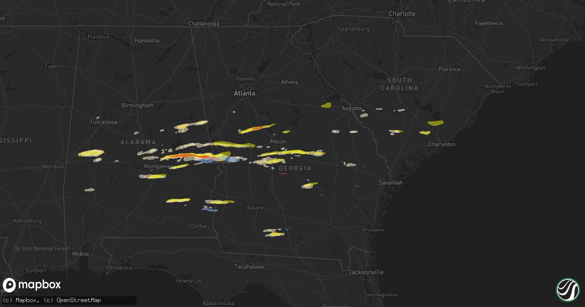
Hail Map in Georgia on December 30, 2021
Get this storm
December 30 map
$229
one time, instant access
Download today. No call, no setup
Keep the $229
Bought the map and want the full workflow? Apply the entire $229 to a subscription within 7 days. None of it is wasted.
Every map, not just this one
This buys you this map. Subscription and you get every map we run, in the markets you choose from a few cities to whole states to nationwide. Plus real-time alerts the moment a storm fires.
Contact data
Name, contact info, occupancy, even credit band for addresses in the footprint. You go from where it hit to who to call.
Become the source they trust
Unlimited branding weather history reports on demand. You already have the documented answer ready for the property owner, and you are the one who showed up with it.
Property data and RoofTrace estimates
Pull up any address you have got, its value and the exact code rules for that jurisdiction, straight from One Click Code. Then RoofTrace estimates the squares, pitch, and roof value, priced the way you price.
Storm reports in Georgia
Georgia
| Date | Description |
|---|---|
| 12/30/20213:30 PM CST | Emergency manager reports possible tornado. Damage includes trees and power lines down near the denton area. Time is approximate from radar imagery. |
| 12/30/20213:27 PM CST | Tree snapped at the 2600 block of hwy 341 s. |
| 12/30/20213:14 PM CST | Nickel to quarter sized hail reported on mckee rd near the intersection of county line rd. |
| 12/30/20213:12 PM CST | Report of 2 homes with roof damage... And trees downed. Time estimated by radar. |
| 12/30/20213:10 PM CST | Emergency manager reports possible tornado. Damage includes trees down... Minor roof damage as well as some lines down in the roper vicinity. Time is approximate from r |
| 12/30/20213:09 PM CST | Quarter sized hail reported in the deer run subdivision in ellerslie. |
| 12/30/20213:03 PM CST | Numerous trees reported down in eastern cook county. Radar confirmed tornado via tds from kvax radar. |
| 12/30/20213:03 PM CST | Quarter-sized hail reported in ne columbus near flat rock park. |
| 12/30/20213:02 PM CST | Structural damage reported in eastern cook county west of sr-76. |
| 12/30/20213:00 PM CST | Trees down and some debris in roadways in the central and eastern part of the county. |
| 12/30/20213:00 PM CST | The public reported hail the size of quarters on lloyd road. |
| 12/30/20212:58 PM CST | Quarter-sized hail reported near the intersection of river rd and veteran's pkwy. |
| 12/30/20212:19 PM CST | Tornado confirmed on the ground south of spence field. Damage to at least 3 residences in the area. Time confirmed by tds signature on radar. |
| 12/30/20212:11 PM CST | A few trees reported down in moultrie. |
| 12/30/20218:10 AM CST | Tree reported down at the intersection of jefferson st and main st. |
| 12/30/20218:02 AM CST | Tree reported down at the intersection of lazenby rd and welcome rd. |
| 12/30/20218:00 AM CST | Tree reported down at the intersection of providence rd and keith rd. |
| 12/30/20213:28 AM CST | At 928 AM EST, a severe thunderstorm was located near Fayetteville, moving east at 40 mph. HAZARD...60 mph wind gusts. SOURCE...Radar indicated. IMPACT...Expect damage to roofs, siding, and trees. Locations impacted include... McDonough, Fayetteville, Jonesboro, Peachtree City, Stockbridge, Hampton, Tyrone, Lovejoy, Locust Grove, Woolsey, Lake Spivey, Blacksville, Inman, Bonanza, Luella, Atlanta Motor Speedway, Jw Smith Reservoir, Flippen, Eagles Landing and Irondale. |
| 12/30/20213:07 AM CST | At 907 AM EST, a severe thunderstorm was located near East Newnan, or near Newnan, moving east at 45 mph. HAZARD...60 mph wind gusts. SOURCE...Radar indicated. IMPACT...Expect damage to roofs, siding, and trees. Locations impacted include... Newnan, Fayetteville, Peachtree City, Tyrone, Senoia, Sharpsburg, Turin, Woolsey, East Newnan, Starrs Mill, Inman, Cannongate, Jw Smith Reservoir, Sandy Creek, Thomas Crossroads, Madras, Irondale and Bonanza. |
| 12/30/20212:17 AM CST | At 816 PM EST, a severe thunderstorm was located over Brooklet, moving east at 25 mph. HAZARD...60 mph wind gusts and quarter size hail. SOURCE...Radar indicated. IMPACT...Minor hail damage to vehicles is possible. Expect wind damage to trees and powerlines. Locations impacted include: Guyton, Brooklet, Pineora, Egypt, Shawnee, Leefield and Stilson. |
| 12/30/20211:42 AM CST | At 742 PM EST, a severe thunderstorm was located over Tarrytown, or near Soperton, moving east at 30 mph. HAZARD...60 mph wind gusts. SOURCE...Radar indicated. IMPACT...Expect damage to roofs, siding, and trees. Locations impacted include... Lyons, Soperton, Vidalia, Oak Park, Tarrytown, Ponderosa, Zaidee, Kibbee and Normantown. |
| 12/30/202112:37 AM CST | At 637 PM EST, a severe thunderstorm was located over Du Pont, or near Homerville, moving east at 25 mph. HAZARD...60 mph wind gusts and quarter size hail. SOURCE...Radar indicated. IMPACT...Hail damage to vehicles is expected. Expect wind damage to roofs, siding, and trees. Locations impacted include... Homerville, Argyle and Du Pont. |
| 12/30/202112:25 AM CST | At 625 PM EST, a severe thunderstorm was located over East Crisp, or near Cordele, moving east at 30 mph. HAZARD...60 mph wind gusts and nickel size hail. SOURCE...Radar indicated. IMPACT...Expect damage to roofs, siding, and trees. Locations impacted include... Rochelle, Pitts, East Crisp, Pleasant View, Tippettville, Tremont, Pope City, Seville and Cedar Creek. |
| 12/29/202111:58 PM CST | At 558 PM EST, a severe thunderstorm was located over Drayton, or 7 miles west of Vienna, moving east at 35 mph. HAZARD...60 mph wind gusts and nickel size hail. SOURCE...Radar indicated. IMPACT...Expect damage to roofs, siding, and trees. Locations impacted include... Cordele, Vienna, Drayton and Richwood. |
| 12/29/202111:45 PM CST | At 545 PM EST, severe thunderstorms were located along a line extending from near Gordon to Mock Springs, moving east at 40 mph. HAZARD...60 mph wind gusts and penny size hail. SOURCE...Radar indicated. IMPACT...Expect damage to roofs, siding, and trees. Locations impacted include... Cochran, Hawkinsville, Jeffersonville, Irwinton, Toomsboro, Danville, Montrose, Allentown, Marion, Dubois, Browndale, Tarversville, Empire, Mobley Crossing, Mock Springs, Roddy, Nicklesville, Baileys Park, Ocmulgee Banks and Royal. |
| 12/29/202111:20 PM CST | At 520 PM EST, a severe thunderstorm was located 9 miles northeast of Lakeland, moving east at 20 mph. HAZARD...60 mph wind gusts and quarter size hail. SOURCE...Radar indicated. IMPACT...Hail damage to vehicles is expected. Expect wind damage to roofs, siding, and trees. Locations impacted include... Homerville, Argyle, Cogdell and Axson. |
| 12/29/202111:13 PM CST | At 513 PM EST/413 PM CST/, a severe thunderstorm was located over Abbeville, moving east at 25 mph. HAZARD...60 mph wind gusts and penny size hail. SOURCE...Radar indicated. IMPACT...Expect damage to roofs, siding, and trees. Locations impacted include... Abbeville, Fort Gaines, Bellville, Bluffton, Shorterville, Walter F. George Lock And Dam, Walter F George Lake, Hayes, Pecan, Graball, Jones Crossing, Suttons Corner, Fort Gaines-Clay Airport, Harrisons Mill, Barnes, Hardwickburg, Zetto, Colomokee, Murphy Station and Screamer. |
| 12/29/202111:09 PM CST | At 508 PM EST, a severe thunderstorm was located 7 miles south of Cuthbert, moving east at 40 mph. HAZARD...60 mph wind gusts and quarter size hail. SOURCE...Radar indicated. IMPACT...Hail damage to vehicles is expected. Expect wind damage to roofs, siding, and trees. Locations impacted include... Cuthbert, Dawson, Shellman, Walker, Sasser, Carnegie, Moye, Herod, Cordrays Mill, Clarks Mill, Dawson Municipal A/P, Fountain Bridge, Goffs Mill, Shivers Mill, Aycock Mill, Martins Crossroads, Chickasawhatchee and Doverel. |
| 12/29/202111:03 PM CST | At 503 PM EST, a severe thunderstorm was located over Cochran, moving east at 35 mph. HAZARD...60 mph wind gusts and nickel size hail. SOURCE...Radar indicated. IMPACT...Expect damage to roofs, siding, and trees. Locations impacted include... Dublin, Cochran, Chester, Dexter, Dudley, Cadwell, Rentz, Montrose, Yonkers, Roddy, Rowland, Royal, Harlow, Goldsboro and Rebie. |
| 12/29/202110:59 PM CST | At 458 PM EST, severe thunderstorms were located along a line extending from near Lizella to near Plains, moving east at 45 mph. HAZARD...60 mph wind gusts and nickel size hail. SOURCE...Radar indicated. IMPACT...Expect damage to roofs, siding, and trees. Locations impacted include... Macon, Perry, Fort Valley, Vienna, Oglethorpe, Warner Robins, Centerville, Byron, Unadilla, Montezuma, Marshallville, Byromville, Pinehurst, Andersonville, Lilly, Dooling, Robins Air Force Base, Hayneville, Houston Lake and New Era. |
| 12/29/202110:50 PM CST | At 450 PM EST, a severe thunderstorm was located over Butler, moving east at 30 mph. HAZARD...60 mph wind gusts and nickel size hail. SOURCE...Radar indicated. IMPACT...Expect damage to roofs, siding, and trees. Locations impacted include... Butler, Ellaville, Reynolds, Ideal, Putnam, Murrays Crossroads, Whitewater State Park, Nakomis, Fountainville, Rupert, Garden Valley, Draneville, Hicks, Potterville, Doyle, Lee Pope, Bartlett and Walls Crossing. |
| 12/29/202110:47 PM CST | At 447 PM EST, a severe thunderstorm was located near Dublin, moving east at 50 mph. HAZARD...60 mph wind gusts and quarter size hail. SOURCE...Radar indicated. IMPACT...Hail damage to vehicles is expected. Expect wind damage to roofs, siding, and trees. Locations impacted include... Dublin, Wrightsville, East Dublin, Kite, Lovett, Spann, Donovan, New Home, Meeks, Tuckers Crossroad, Brewton and Scott. |
| 12/29/202110:39 PM CST | At 439 PM EST, a severe thunderstorm was located near Fort Gaines, moving east at 40 mph. HAZARD...60 mph wind gusts. SOURCE...Radar indicated. IMPACT...Expect damage to roofs, siding, and trees. Locations impacted include... Fort Gaines, Cuthbert, Shellman, Walter F George Lake, Standleys Store, Carnegie, Watson Crossroads, Ricks Place, Pecan, Randolph Co A/p, Aycock Mill, Morris, Jones Crossing, Martins Crossroads, Bethel, Cotton Hill, Fort Gaines-Clay Airport, Days Crossroads, Springvale Station and Pachitla. |
| 12/29/202110:32 PM CST | At 431 PM EST, a severe thunderstorm was located over Sand Bed, or 7 miles east of Perry, moving east at 30 mph. HAZARD...60 mph wind gusts and nickel size hail. SOURCE...Radar indicated. IMPACT...Expect damage to roofs, siding, and trees. Locations impacted include... Cochran, Royal, Coley Station, Tarversville, Paulk, Cary, Porter and Magnolia. |
| 12/29/202110:28 PM CST | At 428 PM EST, a severe thunderstorm was located over Marion Estates, or 12 miles north of Buena Vista, moving east at 30 mph. HAZARD...60 mph wind gusts and quarter size hail. SOURCE...Radar indicated. IMPACT...Hail damage to vehicles is expected. Expect wind damage to roofs, siding, and trees. Locations impacted include... Junction City, Geneva, Howard, Marion Estates, Oakland and Mauk. |
| 12/29/202110:27 PM CST | At 427 PM EST, a severe thunderstorm was located near Snipesville, or near Broxton, moving east at 30 mph. HAZARD...60 mph wind gusts. SOURCE...Radar indicated. IMPACT...Expect damage to roofs, siding, and trees. Locations impacted include... Graham and Denton. |
| 12/29/202110:25 PM CST | At 425 PM EST, a severe thunderstorm was located over Alexander, or 8 miles southwest of Plant Vogtle, moving east at 40 mph. HAZARD...60 mph wind gusts and quarter size hail. SOURCE...Radar indicated. IMPACT...Hail damage to vehicles is expected. Expect wind damage to roofs, siding, and trees. Locations impacted include... Plant Vogtle, Sardis, Alexander and Girard. |
| 12/29/202110:15 PM CST | At 413 PM EST, a severe thunderstorm was located near Danville, or near Jeffersonville, moving east at 30 mph. HAZARD...60 mph wind gusts and nickel size hail. SOURCE...Radar indicated. IMPACT...Expect damage to roofs, siding, and trees. Locations impacted include... Jeffersonville, Danville, Allentown, Chappells Mill and Nicklesville. |
| 12/29/202110:10 PM CST | At 410 PM EST, a severe thunderstorm was located over Prattsburg, or 11 miles east of Talbotton, moving east at 30 mph. HAZARD...60 mph wind gusts and quarter size hail. SOURCE...Radar indicated. IMPACT...Hail damage to vehicles is expected. Expect wind damage to roofs, siding, and trees. Locations impacted include... Roberta, Culloden, Logtown, Salem, Prattsburg, Carsonville and Musella. |
| 12/29/202110:05 PM CST | At 405 PM EST, a severe thunderstorm was located over Saint Louis, or near Fort Valley, moving east at 45 mph. HAZARD...60 mph wind gusts and quarter size hail. SOURCE...Radar indicated. IMPACT...Hail damage to vehicles is expected. Expect wind damage to roofs, siding, and trees. Locations impacted include... Perry, Fort Valley, Warner Robins, Centerville, Byron, Marshallville, Robins Air Force Base, Saint Louis, Meadowdale, Sand Bed, Houston Lake, Lakewood, Powerville, Bonaire, Miami Valley, Kathleen and Moss Oak. |
| 12/29/20219:57 PM CST | At 357 PM EST, a severe thunderstorm was located near Pavo, or 9 miles southeast of Moultrie, moving east at 30 mph. HAZARD...60 mph wind gusts and quarter size hail. SOURCE...Radar indicated. IMPACT...Hail damage to vehicles is expected. Expect wind damage to roofs, siding, and trees. Locations impacted include... Adel, Moultrie, Hahira, Sparks, Berlin, Cecil, Reed Bingham State Park, Cook Co A/P, Barney, Massee, Autreyville, Greggs, Pine Valley, Spence Airport and I-75 At Exit 29. |
| 12/29/20219:40 PM CST | At 340 PM EST, a severe thunderstorm was located near Waverly Hall, or near Hamilton, moving east at 30 mph. HAZARD...60 mph wind gusts and nickel size hail. SOURCE...Radar indicated. IMPACT...Expect damage to roofs, siding, and trees. Locations impacted include... Manchester, Waverly Hall, Warm Springs, Woodland, Sunset Village, Sprewell Bluff State Park, Pleasant Hill, Big Lazer Creek Wma and Flint Hill. |
| 12/29/20219:30 PM CST | At 330 PM EST, a severe thunderstorm was located over District Path, or near Jeffersonville, moving east at 30 mph. HAZARD...60 mph wind gusts and nickel size hail. SOURCE...Radar indicated. IMPACT...Expect damage to roofs, siding, and trees. Locations impacted include... Irwinton, Toomsboro and Nicklesville. |
| 12/29/20219:02 PM CST | At 302 PM EST, a severe thunderstorm was located near Moultrie, moving east at 30 mph. HAZARD...60 mph wind gusts and quarter size hail. SOURCE...Radar indicated. IMPACT...Hail damage to vehicles is expected. Expect wind damage to roofs, siding, and trees. Locations impacted include... Moultrie, Adel, Sparks, Riverside, Berlin, Funston, Cecil, Ellenton, Reed Bingham State Park, Cook Co A/P, Pineboro, Massee, Autreyville, Greggs, Barneyville, Pine Valley, Spence Airport, South Moultrie, Moultrie Municipal A/P and Laconte. |
| 12/29/20218:59 PM CST | At 258 PM EST, a severe thunderstorm was located over Elberta, or 13 miles south of Macon, moving east at 35 mph. HAZARD...60 mph wind gusts and penny size hail. SOURCE...Radar indicated. IMPACT...Expect damage to roofs, siding, and trees. Locations impacted include... Jeffersonville, Warner Robins, Robins Air Force Base, Marion, Bullard, Elberta, Fitzpatrick, Ripley and Huber. |
| 12/29/20218:49 PM CST | At 249 PM EST, a severe thunderstorm was located over Clinton, or over Gray, moving east at 40 mph. HAZARD...60 mph wind gusts and penny size hail. SOURCE...Radar indicated. IMPACT...Expect damage to roofs, siding, and trees. Locations impacted include... Milledgeville, Gray, Midway-Hardwick, Postell, James, Coopers, Underwood, Allenwood, Haddock, Pancras, Greenberry Crossroads, Clinton, Scottsboro, Hardwick and Browns Crossing. |
| 12/29/20218:45 PM CST | At 243 PM EST, a severe thunderstorm was located over Juliette, or 10 miles northeast of Forsyth, moving east at 40 mph. HAZARD...60 mph wind gusts and penny size hail. SOURCE...Radar indicated. IMPACT...Expect damage to roofs, siding, and trees. Locations impacted include... Eatonton, Ethridge, Hillsboro, Berner, Resseaus Crossroads, Round Oak, Juliette, Stanfordville, Adgateville, Blountsville and Willard. |
| 12/29/20218:31 PM CST | At 231 PM EST, a severe thunderstorm was located over Lee Pope, or near Fort Valley, moving east at 35 mph. HAZARD...60 mph wind gusts and nickel size hail. SOURCE...Radar indicated. IMPACT...Expect damage to roofs, siding, and trees. Locations impacted include... Fort Valley, Warner Robins, Centerville, Byron, Nakomis, Powerville, Jack Brown Estates, Elberta, Lee Pope and Lakewood. |
| 12/29/20218:18 PM CST | At 218 PM EST, a severe thunderstorm was located over Meansville, or near Zebulon, moving east at 50 mph. HAZARD...60 mph wind gusts and penny size hail. SOURCE...Radar indicated. IMPACT...Expect damage to roofs, siding, and trees. Locations impacted include... Barnesville, Jackson, Forsyth, Zebulon, Flovilla, Milner, Orchard Hill, Meansville, Aldora, Goggins, Berner, Chappel Mill, High Falls State Park, Blount, Liberty Hill, McElheneys Crossroads, Collier, Juliette, Piedmont and Johnstonville. |
| 12/29/20218:09 PM CST | At 208 PM CST, a severe thunderstorm was located over Auburn University, or over Auburn, moving east at 40 mph. HAZARD...Ping pong ball size hail and 60 mph wind gusts. SOURCE...Radar indicated. IMPACT...People and animals outdoors will be injured. Expect hail damage to roofs, siding, windows, and vehicles. Expect wind damage to roofs, siding, and trees. Locations impacted include... Auburn, Opelika, Beulah, Beauregard, Bleecker, Beans Mill, Auburn University, Robert G. Pitts Airport, Chewacla State Park and Mount Jefferson. |
| 12/29/20218:01 PM CST | At 201 PM CST, a severe thunderstorm was located over Cusseta, or near Valley, moving east at 40 mph. HAZARD...60 mph wind gusts and quarter size hail. SOURCE...Radar indicated. IMPACT...Hail damage to vehicles is expected. Expect wind damage to roofs, siding, and trees. Locations impacted include... Valley, Lanett, Cusseta, River View, Huguley, Fairfax, I 85 Welcome Center At Lanett and Lanett Municipal Airport. |
| 12/29/20217:32 PM CST | At 131 PM EST, a severe thunderstorm was located over Scotland, or near McRae, moving northeast at 30 mph. HAZARD...60 mph wind gusts and penny size hail. SOURCE...Radar indicated. IMPACT...Expect damage to roofs, siding, and trees. Locations impacted include... McRae, Alamo, Mount Vernon, Helena, Glenwood, Scotland, Towns, Spring Hill, Little Ocmulgee State Park and Jordan. |
All States Impacted by Hail Map on December 30, 2021
Cities Impacted by Hail Map on December 30, 2021
- Letohatchee, AL
- Hope Hull, AL
- Ramer, AL
- Hayneville, AL
- Montgomery, AL
- Byron, GA
- Greensboro, AL
- Boligee, AL
- Gallion, AL
- Forkland, AL
- Sawyerville, AL
- Livingston, AL
- Faunsdale, AL
- Wadley, AL
- Daviston, AL
- Cragford, AL
- Alexander City, AL
- Ashland, AL
- Smiths Station, AL
- Gray, GA
- Macon, GA
- Haddock, GA
- Prattville, AL
- Troy, AL
- Goshen, AL
- Brundidge, AL
- Clio, AL
- Ariton, AL
- Shorter, AL
- Hardaway, AL
- Tuskegee, AL
- Adrian, GA
- Wrightsville, GA
- East Dublin, GA
- Meansville, GA
- Danville, GA
- Dublin, GA
- Montrose, GA
- Jeffersonville, GA
- Irwinton, GA
- Dry Branch, GA
- Salem, AL
- Opelika, AL
- Fortson, GA
- Phenix City, AL
- Columbus, GA
- Auburn, AL
- Midland, GA
- Louisville, GA
- Camp Hill, AL
- Waverly, AL
- Dadeville, AL
- Deatsville, AL
- Marbury, AL
- Goodwater, AL
- Roanoke, AL
- Franklin, GA
- Woodland, GA
- Forsyth, GA
- The Rock, GA
- Barnesville, GA
- Molena, GA
- Zebulon, GA
- Milner, GA
- Moultrie, GA
- Pavo, GA
- Coolidge, GA
- Berlin, GA
- Barney, GA
- Adel, GA
- Perry, GA
- Warner Robins, GA
- Summerville, SC
- Wetumpka, AL
- Fort Gaines, GA
- Cuthbert, GA
- Coleman, GA
- Abbeville, AL
- Juliette, GA
- Concord, GA
- Thomaston, GA
- Jemison, AL
- Montevallo, AL
- Randolph, AL
- Eclectic, AL
- Shorterville, AL
- Tallassee, AL
- Reynolds, GA
- Rupert, GA
- Lodge, SC
- Islandton, SC
- McRae Helena, GA
- Milan, GA
- Notasulga, AL
- Auburn University, AL
- Cataula, GA
- Williston, SC
- Blackville, SC
- Coker, AL
- Marshallville, GA
- Hartsfield, GA
- Meigs, GA
- Metter, GA
- Lafayette, AL
- Fort Valley, GA
- Valley, AL
- Cusseta, AL
- Pike Road, AL
- Hamilton, GA
- Montezuma, GA
- Ideal, GA
- Kathleen, GA
- Cochran, GA
- Elko, GA
- Oglethorpe, GA
- Bonaire, GA
- Shiloh, GA
- Pine Mountain Valley, GA
- Pine Mountain, GA
- Twin City, GA
- Cecil, AL
- Tuskegee Institute, AL
- Morris, GA
- Eufaula, AL
- Waynesboro, GA
- Peachtree City, GA
- Sharpsburg, GA
- Box Springs, GA
- Sardis, GA
- Ehrhardt, SC
- Brunson, SC
- Hampton, SC
- Titus, AL
- Fairfax, SC
- Millbrook, AL
- Booth, AL
- Elmore, AL
- Autaugaville, AL
- Mauk, GA
- Junction City, GA
- Lizella, GA
- Centerville, GA
- Weogufka, AL
- Sylacauga, AL
- Ridgeville, SC
- Thomasville, AL
- Musella, GA
- Roberta, GA
- Jackson, SC
- Fort Benning, GA
- Orangeburg, SC
- Rowesville, SC
- Cordova, SC
- Norman Park, GA
- Louisville, AL
- Statesboro, GA
- Pulaski, GA
- Register, GA
- West Point, GA
- Talbotton, GA
- Waverly Hall, GA
- Marion Junction, AL
- Billingsley, AL
- Verbena, AL
- Jones, AL
- Butler, GA
- Minter, AL
- New Ellenton, SC
- Aiken, SC
- Cope, SC
- Equality, AL
- Northport, AL
- Kellyton, AL
- Union Springs, AL
- Newbern, AL
- Ellerslie, GA
- Upatoi, GA
- Newville, AL
- Williams, SC
- Ruffin, SC
- Pinopolis, SC
- Moncks Corner, SC
- Hazlehurst, GA
- Glennville, GA
- Hawkinsville, GA
- Brooklet, GA
- Sparks, GA
- Idaho Springs, CO
- Strasburg, CO
- Cripple Creek, CO
- Niwot, CO
- Calhan, CO
- Loveland, CO
- Louviers, CO
- Monument, CO
- Pine, CO
- Wheatland, WY
- Boulder, CO
- Golden, CO
- Glendo, WY
- Medicine Bow, WY
- Empire, CO
- Deer Trail, CO
- Estes Park, CO
- Berthoud, CO
- Parshall, CO
- Canon City, CO
- Evansville, WY
- Buffalo Creek, CO
- Johnstown, CO
- Lusk, WY
- Louisville, CO
- Drake, CO
- Glen Haven, CO
- Windsor, CO
- Usaf Academy, CO
- Bosler, WY
- Lafayette, CO
- Hartville, WY
- Dumont, CO
- Florissant, CO
- Douglas, WY
- Bairoil, WY
- Fountain, CO
- Livermore, CO
- Black Hawk, CO
- Woodland Park, CO
- Franktown, CO
- Silver Plume, CO
- Hanna, WY
- Cascade, CO
- Gillette, WY
- Castle Rock, CO
- Lingle, WY
- Tie Siding, WY
- Jay Em, WY
- Rock River, WY
- Alcova, WY
- Agate, CO
- Bailey, CO
- Divide, CO
- Buford, WY
- Indian Hills, CO
- Natrona, WY
- Rollinsville, CO
- Colorado Springs, CO
- Idledale, CO
- Casper, WY
- Granby, CO
- Elbert, CO
- Kiowa, CO
- Bellvue, CO
- Ward, CO
- Fraser, CO
- Longmont, CO
- Sedalia, CO
- Eldorado Springs, CO
- Wellington, CO
- Carr, CO
- Victor, CO
- Brighton, CO
- Guernsey, WY
- Lone Tree, CO
- Westminster, CO
- Larkspur, CO
- Shawnee, WY
- Nunn, CO
- Byers, CO
- Shoshoni, WY
- Centennial, WY
- Manitou Springs, CO
- Jeffrey City, WY
- Veteran, WY
- Georgetown, CO
- Littleton, CO
- Ramah, CO
- Ault, CO
- Grover, CO
- Aurora, CO
- Chugwater, WY
- Penrose, CO
- Greeley, CO
- Laporte, CO
- Parker, CO
- Fort Laramie, WY
- Palmer Lake, CO
- Fort Collins, CO
- Garrett, WY
- Arvada, CO
- Rawlins, WY
- Denver, CO
- Lyons, CO
- Glenrock, WY
- Erie, CO
- Red Feather Lakes, CO
- Walden, CO
- Allenspark, CO
- Manville, WY
- Lost Springs, WY
- Wheat Ridge, CO
- Laramie, WY
- Grand Lake, CO
- Nederland, CO
- Mills, WY
- Central City, CO
- Kittredge, CO
- Bennett, CO
- Evergreen, CO
- Lance Creek, WY
- Conifer, CO
- Winter Park, CO
- Granite Canon, WY
- Elk Mountain, WY
- Jamestown, CO
- Broomfield, CO
- Morrison, CO
- Dillon, CO
- Jelm, WY
- Peyton, CO
- Cheyenne, WY
- Yoder, WY
- Elizabeth, CO
- Green Mountain Falls, CO
- Wamsutter, WY
- Norwood, GA
- Thomson, GA
- Camak, GA
- Warrenton, GA
- Alamo, GA
- Monticello, GA
- Milledgeville, GA
- Culloden, GA
- Shellman, GA
- Kite, GA


