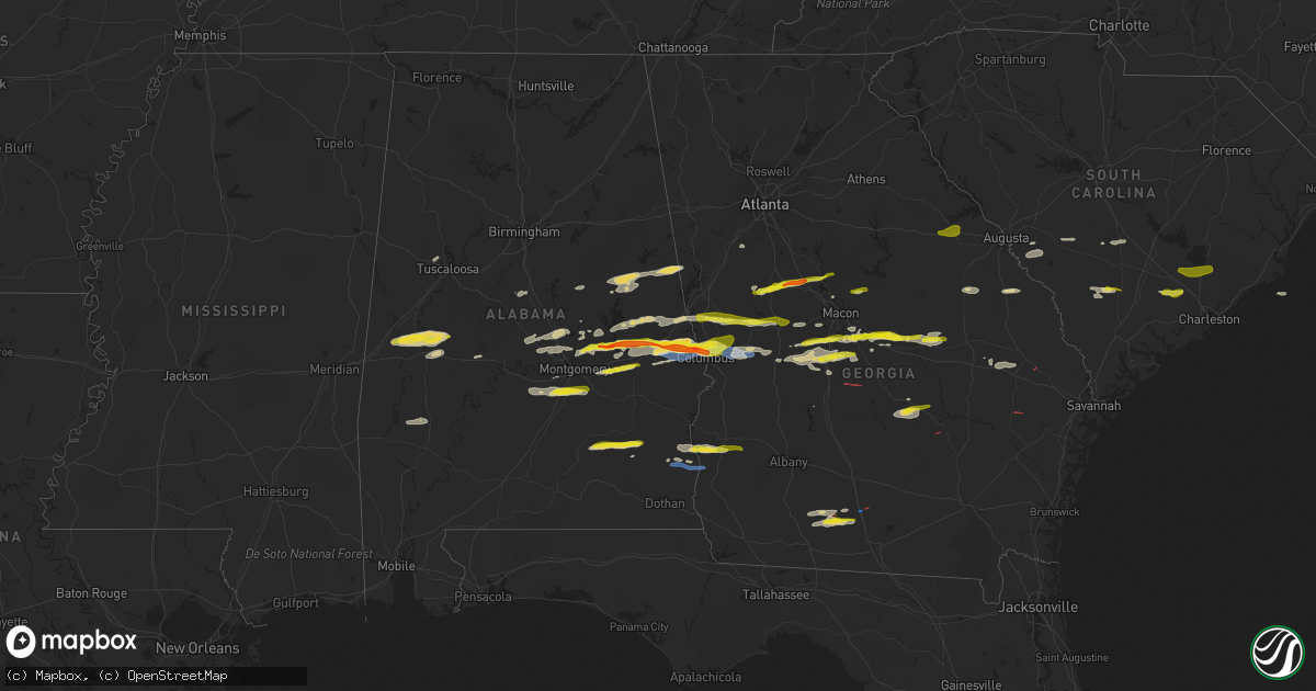
Hail Map on December 30, 2021
Get this storm
December 30 map
$229
one time, instant access
Download today. No call, no setup
Keep the $229
Bought the map and want the full workflow? Apply the entire $229 to a subscription within 7 days. None of it is wasted.
Every map, not just this one
This buys you this map. Subscription and you get every map we run, in the markets you choose from a few cities to whole states to nationwide. Plus real-time alerts the moment a storm fires.
Contact data
Name, contact info, occupancy, even credit band for addresses in the footprint. You go from where it hit to who to call.
Become the source they trust
Unlimited branding weather history reports on demand. You already have the documented answer ready for the property owner, and you are the one who showed up with it.
Property data and RoofTrace estimates
Pull up any address you have got, its value and the exact code rules for that jurisdiction, straight from One Click Code. Then RoofTrace estimates the squares, pitch, and roof value, priced the way you price.
States Impacted by Hail Map on December 30, 2021
Storm reports
Alabama
| Date | Description |
|---|---|
| 12/30/20214:23 PM CST | A few trees down north of abbeville. |
| 12/30/20212:47 PM CST | Golf ball size hail in smiths station. |
| 12/30/20212:28 PM CST | Silver dollar size hail in beauregard. |
| 12/30/20212:25 PM CST | Quarter size hail near lee road 54 and lee road 146..... |
| 12/30/20212:25 PM CST | Barn and residential roof damage on lee road 11. |
| 12/30/20212:10 PM CST | Tree down on county road 3310 and tree down on county road 3319. Hail of unknown size in brundidge. |
| 12/30/20212:07 PM CST | Multiple trees down highway 14 at mile marker 216. |
| 12/30/20212:05 PM CST | Quarter size hail in loachapoka. |
| 12/30/20211:48 PM CST | At least golf ball size hail near tallassee. |
| 12/30/20214:49 AM CST | At 1048 AM CST, a severe thunderstorm was located near Tishabee, or 9 miles northwest of Demopolis, moving east at 40 mph. HAZARD...60 mph wind gusts and quarter size hail. SOURCE...Radar indicated. IMPACT...Hail damage to vehicles is expected. Expect wind damage to roofs, siding, and trees. Locations impacted include... Demopolis, Greensboro, Forkland, Newbern, Greensboro Municipal Airport, Duffys Bend, Thornhill, Arcola, Tishabee, Belmont, Demopolis Lock And Dam, McDowell, Birdine, Cedarville and Laneville. |
| 12/30/20213:57 AM CST | At 957 AM CST, a severe thunderstorm was located over Jemison, moving east at 40 mph. HAZARD...60 mph wind gusts and penny size hail. SOURCE...Radar indicated. IMPACT...Expect damage to roofs, siding, and trees. Locations impacted include... Clanton, Jemison, Weogufka, Thorsby, Gap Of The Mountain, Strickland Crossroads, Lay Lake Dam, Unity, Marble Valley, Moriah, Lay Lake, Mitchell Lake, Minooka Park, Waxahatchee Creek, Highway 145 and CR 46, Paint Creek, I 65 Rest Area, Spring Creek and Lomax. |
| 12/30/20213:41 AM CST | At 940 AM CST, a severe thunderstorm was located over Goodwater, moving east at 35 mph. HAZARD...60 mph wind gusts and penny size hail. SOURCE...Radar indicated. IMPACT...Expect damage to roofs, siding, and trees. Locations impacted include... Alexander City, Goodwater, Kellyton, New Site, Goldville, Hillabee Creek, Bradford, Parkdale, Hatchet, Northern Lake Martin, Daviston, Cleveland Crossroads, Horseshoe Bend National Military Park, Hackneyville, Horseshoe Bend and Motley. |
| 12/29/202110:23 PM CST | At 423 PM EST, a severe thunderstorm was located over Christopher, or near Cusseta, moving east at 40 mph. HAZARD...60 mph wind gusts and quarter size hail. SOURCE...Radar indicated. IMPACT...Hail damage to vehicles is expected. Expect wind damage to roofs, siding, and trees. Locations impacted include... Buena Vista, Cusseta, Richland, Brantley, Seminole, Charles, Christopher, Jamestown/south Fort Benning, Brooklyn, Renfroe, Manta, Zellobee, Tazewell, Church Hill, Louvale and Providence Canyon State Park. |
| 12/29/20219:59 PM CST | At 359 PM EST, a severe thunderstorm was located over Highland Park, or over Columbus, moving east at 45 mph. HAZARD...Ping pong ball size hail and 60 mph wind gusts. SOURCE...Radar indicated. IMPACT...People and animals outdoors will be injured. Expect hail damage to roofs, siding, windows, and vehicles. Expect wind damage to roofs, siding, and trees. Locations impacted include... North Fort Benning, Upatoi, Saint Marys Hills, Edgewood, Highland Park, Sand Hill, Juniper, Vista Terrace, Box Springs, Kenwood, Eelbeck/West Fort Benning, Benning Hills, Avondale, Benning Park and Carter Acres. |
| 12/29/20219:45 PM CST | At 344 PM EST, a severe thunderstorm was located near Goat Rock Lake, or near Smiths, moving east at 30 mph. HAZARD...60 mph wind gusts and quarter size hail. SOURCE...Radar indicated. IMPACT...Hail damage to vehicles is expected. Expect wind damage to roofs, siding, and trees. Locations impacted include... Bibb City, Goat Rock Lake, Ellerslie, Flat Rock, Laurel Hills, Green Island Hills, Cataula, Columbus Metropolitan Airport, Midland, Mountain Hill, Bartletts Ferry Dam, Fortson, Mulberry Grove and Lake Harding. |
| 12/29/20219:15 PM CST | At 315 PM EST, a severe thunderstorm was located near River View, or near Valley, moving east at 40 mph. HAZARD...60 mph wind gusts and penny size hail. SOURCE...Radar indicated. IMPACT...Expect damage to roofs, siding, and trees. Locations impacted include... Hamilton, Greenville, Manchester, West Point, Pine Mountain, Warm Springs, F.d. Roosevelt State Park, Odessadale, Stovall, Mountain Hill, Big Springs, Durand, Jones Crossroads, Baughs Crossroads, Harris City and Whitesville-Pine Lake. |
| 12/29/20218:41 PM CST | At 241 PM CST, a severe thunderstorm was located over Bleecker, or near Smiths, moving east at 40 mph. HAZARD...Ping pong ball size hail and 60 mph wind gusts. SOURCE...Radar indicated. IMPACT...People and animals outdoors will be injured. Expect hail damage to roofs, siding, windows, and vehicles. Expect wind damage to roofs, siding, and trees. Locations impacted include... Phenix City, Smiths, Smiths Station, Ladonia, Bleecker, Monterey Heights, Ladonia Sports Complex, Phenix Drag Strip, Parkmanville and Bartletts Ferry Dam. |
| 12/29/20218:23 PM CST | At 223 PM CST, a severe thunderstorm was located near Liverpool, or near Milstead, moving east at 40 mph. HAZARD...60 mph wind gusts and half dollar size hail. SOURCE...Radar indicated. IMPACT...Hail damage to vehicles is expected. Expect wind damage to roofs, siding, and trees. Locations impacted include... Tuskegee, Milstead, Shorter, Franklin, Liverpool, Lake Tuskegee, Hardaway, Davisville, Society Hill, Warriorstand, Cross Keys, Creek Stand and Moton Field Municipal Airport. |
| 12/29/20218:16 PM CST | At 216 PM CST, a severe thunderstorm was located over Brundidge, moving east at 40 mph. HAZARD...Golf ball size hail and 60 mph wind gusts. SOURCE...Radar indicated. IMPACT...People and animals outdoors will be injured. Expect hail damage to roofs, siding, windows, and vehicles. Expect wind damage to roofs, siding, and trees. Locations impacted include... Clio, Louisville, Tyler Crossroads, Texasville, Gaino, Richards Crossroads, Blue Springs State Park, Millers Ford and Baker Hill. |
| 12/29/20217:57 PM CST | At 157 PM CST, a severe thunderstorm was located over Hayneville, moving east at 40 mph. HAZARD...60 mph wind gusts and quarter size hail. SOURCE...Radar indicated. IMPACT...Hail damage to vehicles is expected. Expect wind damage to roofs, siding, and trees. Locations impacted include... Southern Montgomery, Mosses, Hayneville, Pike Road, White Hall, Gordonville, Lowndesboro, Hyundai Motors Of Alabama, Beechwood, Hope Hull, Dannelly Field, Snowdoun, Sprague, Pinedale, Waugh, Pintlala, Woodcrest, Carters Hill, Letohatchee and Barachias. |
| 12/29/20217:51 PM CST | At 150 PM CST, a severe thunderstorm was located over Goshen, moving east at 40 mph. HAZARD...60 mph wind gusts and quarter size hail. SOURCE...Radar indicated. IMPACT...Hail damage to vehicles is expected. Expect wind damage to roofs, siding, and trees. Locations impacted include... Troy, Brundidge, Goshen, Banks, Antioch, Troy University, Brundidge Municipal Airport, Monticello, Mossy Grove and Henderson. |
| 12/29/20217:36 PM CST | At 135 PM CST, a severe thunderstorm was located near Eclectic, or 8 miles west of Tallassee, moving east at 40 mph. HAZARD...60 mph wind gusts and quarter size hail. SOURCE...Radar indicated. IMPACT...Hail damage to vehicles is expected. Expect wind damage to roofs, siding, and trees. Locations impacted include... Auburn, Tuskegee, Tallassee, Notasulga, Eclectic, Waverly, Liberty City, Reeves Airport, Tallapoosa City, Loachapoka, Claud, Yates Dam, I 85 Rest Area, Roxana, Reeltown and Yates Reservoir. |
South Carolina
| Date | Description |
|---|---|
| 12/30/20214:10 PM CST | A spotter reported quarter size hail near the intersection of boone hill and old orangeburg rd. |
| 12/30/20213:50 PM CST | A local report indicates 1.00 inch wind near MONCKS CORNER |
| 12/30/20213:45 PM CST | A local report indicates 1.00 inch wind near MONCKS CORNER |
| 12/29/202110:55 PM CST | At 454 PM EST, a severe thunderstorm was located over Givhans Ferry State Park, moving east at 50 mph. HAZARD...60 mph wind gusts and quarter size hail. SOURCE...Radar indicated. IMPACT...Minor hail damage to vehicles is possible. Expect wind damage to trees and powerlines. Locations impacted include: North Charleston, Summerville, Goose Creek, Ladson, Givhans Ferry State Park, Ridgeville, Givhans, Sangaree, Crowfield Plantation, Jedburg, Knightsville and College Park.This warning includes I-26 between mile markers 192 and 205. |
| 12/29/202110:11 PM CST | At 410 PM EST, a severe thunderstorm was located over Ashton, moving east at 20 mph. HAZARD...60 mph wind gusts and quarter size hail. SOURCE...Radar indicated. IMPACT...Minor hail damage to vehicles is possible. Expect wind damage to trees and powerlines. Locations impacted include: Walterboro, Colleton, Smoaks, Lodge, Williams, Islandton, Ruffin, Padgetts, Ashton and Canadys.This warning includes I-95 in South Carolina between mile markers 55and 69. |
| 12/29/20217:12 PM CST | At 110 PM EST, a severe thunderstorm was located near Wrightsboro, or near Thomson, moving east at 45 mph. HAZARD...60 mph wind gusts and nickel size hail. SOURCE...Radar indicated. IMPACT...Expect damage to roofs, siding, and trees. Locations impacted include... North Augusta, Grovetown, Evans, Thomson, Martinez, Augusta, Clearwater, Belvedere, Edgefield, Harlem, Appling, Clarks Hill Recreation Area, Midtown, Riverwood, Mistletoe State Park, Summerville, Wrightsboro, Augusta Mall, Daniel Field and Village Plaza Shopping Center. |
Georgia
| Date | Description |
|---|---|
| 12/30/20213:30 PM CST | Emergency manager reports possible tornado. Damage includes trees and power lines down near the denton area. Time is approximate from radar imagery. |
| 12/30/20213:27 PM CST | Tree snapped at the 2600 block of hwy 341 s. |
| 12/30/20213:14 PM CST | Nickel to quarter sized hail reported on mckee rd near the intersection of county line rd. |
| 12/30/20213:12 PM CST | Report of 2 homes with roof damage... And trees downed. Time estimated by radar. |
| 12/30/20213:10 PM CST | Emergency manager reports possible tornado. Damage includes trees down... Minor roof damage as well as some lines down in the roper vicinity. Time is approximate from r |
| 12/30/20213:09 PM CST | Quarter sized hail reported in the deer run subdivision in ellerslie. |
| 12/30/20213:03 PM CST | Quarter-sized hail reported in ne columbus near flat rock park. |
| 12/30/20213:03 PM CST | Numerous trees reported down in eastern cook county. Radar confirmed tornado via tds from kvax radar. |
| 12/30/20213:02 PM CST | Structural damage reported in eastern cook county west of sr-76. |
| 12/30/20213:00 PM CST | The public reported hail the size of quarters on lloyd road. |
| 12/30/20213:00 PM CST | Trees down and some debris in roadways in the central and eastern part of the county. |
| 12/30/20212:58 PM CST | Quarter-sized hail reported near the intersection of river rd and veteran's pkwy. |
| 12/30/20212:19 PM CST | Tornado confirmed on the ground south of spence field. Damage to at least 3 residences in the area. Time confirmed by tds signature on radar. |
| 12/30/20212:11 PM CST | A few trees reported down in moultrie. |
| 12/30/20218:10 AM CST | Tree reported down at the intersection of jefferson st and main st. |
| 12/30/20218:02 AM CST | Tree reported down at the intersection of lazenby rd and welcome rd. |
| 12/30/20218:00 AM CST | Tree reported down at the intersection of providence rd and keith rd. |
| 12/30/20213:28 AM CST | At 928 AM EST, a severe thunderstorm was located near Fayetteville, moving east at 40 mph. HAZARD...60 mph wind gusts. SOURCE...Radar indicated. IMPACT...Expect damage to roofs, siding, and trees. Locations impacted include... McDonough, Fayetteville, Jonesboro, Peachtree City, Stockbridge, Hampton, Tyrone, Lovejoy, Locust Grove, Woolsey, Lake Spivey, Blacksville, Inman, Bonanza, Luella, Atlanta Motor Speedway, Jw Smith Reservoir, Flippen, Eagles Landing and Irondale. |
| 12/30/20213:07 AM CST | At 907 AM EST, a severe thunderstorm was located near East Newnan, or near Newnan, moving east at 45 mph. HAZARD...60 mph wind gusts. SOURCE...Radar indicated. IMPACT...Expect damage to roofs, siding, and trees. Locations impacted include... Newnan, Fayetteville, Peachtree City, Tyrone, Senoia, Sharpsburg, Turin, Woolsey, East Newnan, Starrs Mill, Inman, Cannongate, Jw Smith Reservoir, Sandy Creek, Thomas Crossroads, Madras, Irondale and Bonanza. |
| 12/30/20212:17 AM CST | At 816 PM EST, a severe thunderstorm was located over Brooklet, moving east at 25 mph. HAZARD...60 mph wind gusts and quarter size hail. SOURCE...Radar indicated. IMPACT...Minor hail damage to vehicles is possible. Expect wind damage to trees and powerlines. Locations impacted include: Guyton, Brooklet, Pineora, Egypt, Shawnee, Leefield and Stilson. |
| 12/30/20211:42 AM CST | At 742 PM EST, a severe thunderstorm was located over Tarrytown, or near Soperton, moving east at 30 mph. HAZARD...60 mph wind gusts. SOURCE...Radar indicated. IMPACT...Expect damage to roofs, siding, and trees. Locations impacted include... Lyons, Soperton, Vidalia, Oak Park, Tarrytown, Ponderosa, Zaidee, Kibbee and Normantown. |
| 12/30/202112:37 AM CST | At 637 PM EST, a severe thunderstorm was located over Du Pont, or near Homerville, moving east at 25 mph. HAZARD...60 mph wind gusts and quarter size hail. SOURCE...Radar indicated. IMPACT...Hail damage to vehicles is expected. Expect wind damage to roofs, siding, and trees. Locations impacted include... Homerville, Argyle and Du Pont. |
| 12/30/202112:25 AM CST | At 625 PM EST, a severe thunderstorm was located over East Crisp, or near Cordele, moving east at 30 mph. HAZARD...60 mph wind gusts and nickel size hail. SOURCE...Radar indicated. IMPACT...Expect damage to roofs, siding, and trees. Locations impacted include... Rochelle, Pitts, East Crisp, Pleasant View, Tippettville, Tremont, Pope City, Seville and Cedar Creek. |
| 12/29/202111:58 PM CST | At 558 PM EST, a severe thunderstorm was located over Drayton, or 7 miles west of Vienna, moving east at 35 mph. HAZARD...60 mph wind gusts and nickel size hail. SOURCE...Radar indicated. IMPACT...Expect damage to roofs, siding, and trees. Locations impacted include... Cordele, Vienna, Drayton and Richwood. |
| 12/29/202111:45 PM CST | At 545 PM EST, severe thunderstorms were located along a line extending from near Gordon to Mock Springs, moving east at 40 mph. HAZARD...60 mph wind gusts and penny size hail. SOURCE...Radar indicated. IMPACT...Expect damage to roofs, siding, and trees. Locations impacted include... Cochran, Hawkinsville, Jeffersonville, Irwinton, Toomsboro, Danville, Montrose, Allentown, Marion, Dubois, Browndale, Tarversville, Empire, Mobley Crossing, Mock Springs, Roddy, Nicklesville, Baileys Park, Ocmulgee Banks and Royal. |
| 12/29/202111:20 PM CST | At 520 PM EST, a severe thunderstorm was located 9 miles northeast of Lakeland, moving east at 20 mph. HAZARD...60 mph wind gusts and quarter size hail. SOURCE...Radar indicated. IMPACT...Hail damage to vehicles is expected. Expect wind damage to roofs, siding, and trees. Locations impacted include... Homerville, Argyle, Cogdell and Axson. |
| 12/29/202111:13 PM CST | At 513 PM EST/413 PM CST/, a severe thunderstorm was located over Abbeville, moving east at 25 mph. HAZARD...60 mph wind gusts and penny size hail. SOURCE...Radar indicated. IMPACT...Expect damage to roofs, siding, and trees. Locations impacted include... Abbeville, Fort Gaines, Bellville, Bluffton, Shorterville, Walter F. George Lock And Dam, Walter F George Lake, Hayes, Pecan, Graball, Jones Crossing, Suttons Corner, Fort Gaines-Clay Airport, Harrisons Mill, Barnes, Hardwickburg, Zetto, Colomokee, Murphy Station and Screamer. |
| 12/29/202111:09 PM CST | At 508 PM EST, a severe thunderstorm was located 7 miles south of Cuthbert, moving east at 40 mph. HAZARD...60 mph wind gusts and quarter size hail. SOURCE...Radar indicated. IMPACT...Hail damage to vehicles is expected. Expect wind damage to roofs, siding, and trees. Locations impacted include... Cuthbert, Dawson, Shellman, Walker, Sasser, Carnegie, Moye, Herod, Cordrays Mill, Clarks Mill, Dawson Municipal A/P, Fountain Bridge, Goffs Mill, Shivers Mill, Aycock Mill, Martins Crossroads, Chickasawhatchee and Doverel. |
| 12/29/202111:03 PM CST | At 503 PM EST, a severe thunderstorm was located over Cochran, moving east at 35 mph. HAZARD...60 mph wind gusts and nickel size hail. SOURCE...Radar indicated. IMPACT...Expect damage to roofs, siding, and trees. Locations impacted include... Dublin, Cochran, Chester, Dexter, Dudley, Cadwell, Rentz, Montrose, Yonkers, Roddy, Rowland, Royal, Harlow, Goldsboro and Rebie. |
| 12/29/202110:59 PM CST | At 458 PM EST, severe thunderstorms were located along a line extending from near Lizella to near Plains, moving east at 45 mph. HAZARD...60 mph wind gusts and nickel size hail. SOURCE...Radar indicated. IMPACT...Expect damage to roofs, siding, and trees. Locations impacted include... Macon, Perry, Fort Valley, Vienna, Oglethorpe, Warner Robins, Centerville, Byron, Unadilla, Montezuma, Marshallville, Byromville, Pinehurst, Andersonville, Lilly, Dooling, Robins Air Force Base, Hayneville, Houston Lake and New Era. |
| 12/29/202110:50 PM CST | At 450 PM EST, a severe thunderstorm was located over Butler, moving east at 30 mph. HAZARD...60 mph wind gusts and nickel size hail. SOURCE...Radar indicated. IMPACT...Expect damage to roofs, siding, and trees. Locations impacted include... Butler, Ellaville, Reynolds, Ideal, Putnam, Murrays Crossroads, Whitewater State Park, Nakomis, Fountainville, Rupert, Garden Valley, Draneville, Hicks, Potterville, Doyle, Lee Pope, Bartlett and Walls Crossing. |
| 12/29/202110:47 PM CST | At 447 PM EST, a severe thunderstorm was located near Dublin, moving east at 50 mph. HAZARD...60 mph wind gusts and quarter size hail. SOURCE...Radar indicated. IMPACT...Hail damage to vehicles is expected. Expect wind damage to roofs, siding, and trees. Locations impacted include... Dublin, Wrightsville, East Dublin, Kite, Lovett, Spann, Donovan, New Home, Meeks, Tuckers Crossroad, Brewton and Scott. |
| 12/29/202110:39 PM CST | At 439 PM EST, a severe thunderstorm was located near Fort Gaines, moving east at 40 mph. HAZARD...60 mph wind gusts. SOURCE...Radar indicated. IMPACT...Expect damage to roofs, siding, and trees. Locations impacted include... Fort Gaines, Cuthbert, Shellman, Walter F George Lake, Standleys Store, Carnegie, Watson Crossroads, Ricks Place, Pecan, Randolph Co A/p, Aycock Mill, Morris, Jones Crossing, Martins Crossroads, Bethel, Cotton Hill, Fort Gaines-Clay Airport, Days Crossroads, Springvale Station and Pachitla. |
| 12/29/202110:32 PM CST | At 431 PM EST, a severe thunderstorm was located over Sand Bed, or 7 miles east of Perry, moving east at 30 mph. HAZARD...60 mph wind gusts and nickel size hail. SOURCE...Radar indicated. IMPACT...Expect damage to roofs, siding, and trees. Locations impacted include... Cochran, Royal, Coley Station, Tarversville, Paulk, Cary, Porter and Magnolia. |
| 12/29/202110:28 PM CST | At 428 PM EST, a severe thunderstorm was located over Marion Estates, or 12 miles north of Buena Vista, moving east at 30 mph. HAZARD...60 mph wind gusts and quarter size hail. SOURCE...Radar indicated. IMPACT...Hail damage to vehicles is expected. Expect wind damage to roofs, siding, and trees. Locations impacted include... Junction City, Geneva, Howard, Marion Estates, Oakland and Mauk. |
| 12/29/202110:27 PM CST | At 427 PM EST, a severe thunderstorm was located near Snipesville, or near Broxton, moving east at 30 mph. HAZARD...60 mph wind gusts. SOURCE...Radar indicated. IMPACT...Expect damage to roofs, siding, and trees. Locations impacted include... Graham and Denton. |
| 12/29/202110:25 PM CST | At 425 PM EST, a severe thunderstorm was located over Alexander, or 8 miles southwest of Plant Vogtle, moving east at 40 mph. HAZARD...60 mph wind gusts and quarter size hail. SOURCE...Radar indicated. IMPACT...Hail damage to vehicles is expected. Expect wind damage to roofs, siding, and trees. Locations impacted include... Plant Vogtle, Sardis, Alexander and Girard. |
| 12/29/202110:15 PM CST | At 413 PM EST, a severe thunderstorm was located near Danville, or near Jeffersonville, moving east at 30 mph. HAZARD...60 mph wind gusts and nickel size hail. SOURCE...Radar indicated. IMPACT...Expect damage to roofs, siding, and trees. Locations impacted include... Jeffersonville, Danville, Allentown, Chappells Mill and Nicklesville. |
| 12/29/202110:10 PM CST | At 410 PM EST, a severe thunderstorm was located over Prattsburg, or 11 miles east of Talbotton, moving east at 30 mph. HAZARD...60 mph wind gusts and quarter size hail. SOURCE...Radar indicated. IMPACT...Hail damage to vehicles is expected. Expect wind damage to roofs, siding, and trees. Locations impacted include... Roberta, Culloden, Logtown, Salem, Prattsburg, Carsonville and Musella. |
| 12/29/202110:05 PM CST | At 405 PM EST, a severe thunderstorm was located over Saint Louis, or near Fort Valley, moving east at 45 mph. HAZARD...60 mph wind gusts and quarter size hail. SOURCE...Radar indicated. IMPACT...Hail damage to vehicles is expected. Expect wind damage to roofs, siding, and trees. Locations impacted include... Perry, Fort Valley, Warner Robins, Centerville, Byron, Marshallville, Robins Air Force Base, Saint Louis, Meadowdale, Sand Bed, Houston Lake, Lakewood, Powerville, Bonaire, Miami Valley, Kathleen and Moss Oak. |
| 12/29/20219:57 PM CST | At 357 PM EST, a severe thunderstorm was located near Pavo, or 9 miles southeast of Moultrie, moving east at 30 mph. HAZARD...60 mph wind gusts and quarter size hail. SOURCE...Radar indicated. IMPACT...Hail damage to vehicles is expected. Expect wind damage to roofs, siding, and trees. Locations impacted include... Adel, Moultrie, Hahira, Sparks, Berlin, Cecil, Reed Bingham State Park, Cook Co A/P, Barney, Massee, Autreyville, Greggs, Pine Valley, Spence Airport and I-75 At Exit 29. |
| 12/29/20219:40 PM CST | At 340 PM EST, a severe thunderstorm was located near Waverly Hall, or near Hamilton, moving east at 30 mph. HAZARD...60 mph wind gusts and nickel size hail. SOURCE...Radar indicated. IMPACT...Expect damage to roofs, siding, and trees. Locations impacted include... Manchester, Waverly Hall, Warm Springs, Woodland, Sunset Village, Sprewell Bluff State Park, Pleasant Hill, Big Lazer Creek Wma and Flint Hill. |
| 12/29/20219:30 PM CST | At 330 PM EST, a severe thunderstorm was located over District Path, or near Jeffersonville, moving east at 30 mph. HAZARD...60 mph wind gusts and nickel size hail. SOURCE...Radar indicated. IMPACT...Expect damage to roofs, siding, and trees. Locations impacted include... Irwinton, Toomsboro and Nicklesville. |
| 12/29/20219:02 PM CST | At 302 PM EST, a severe thunderstorm was located near Moultrie, moving east at 30 mph. HAZARD...60 mph wind gusts and quarter size hail. SOURCE...Radar indicated. IMPACT...Hail damage to vehicles is expected. Expect wind damage to roofs, siding, and trees. Locations impacted include... Moultrie, Adel, Sparks, Riverside, Berlin, Funston, Cecil, Ellenton, Reed Bingham State Park, Cook Co A/P, Pineboro, Massee, Autreyville, Greggs, Barneyville, Pine Valley, Spence Airport, South Moultrie, Moultrie Municipal A/P and Laconte. |
| 12/29/20218:59 PM CST | At 258 PM EST, a severe thunderstorm was located over Elberta, or 13 miles south of Macon, moving east at 35 mph. HAZARD...60 mph wind gusts and penny size hail. SOURCE...Radar indicated. IMPACT...Expect damage to roofs, siding, and trees. Locations impacted include... Jeffersonville, Warner Robins, Robins Air Force Base, Marion, Bullard, Elberta, Fitzpatrick, Ripley and Huber. |
| 12/29/20218:49 PM CST | At 249 PM EST, a severe thunderstorm was located over Clinton, or over Gray, moving east at 40 mph. HAZARD...60 mph wind gusts and penny size hail. SOURCE...Radar indicated. IMPACT...Expect damage to roofs, siding, and trees. Locations impacted include... Milledgeville, Gray, Midway-Hardwick, Postell, James, Coopers, Underwood, Allenwood, Haddock, Pancras, Greenberry Crossroads, Clinton, Scottsboro, Hardwick and Browns Crossing. |
| 12/29/20218:45 PM CST | At 243 PM EST, a severe thunderstorm was located over Juliette, or 10 miles northeast of Forsyth, moving east at 40 mph. HAZARD...60 mph wind gusts and penny size hail. SOURCE...Radar indicated. IMPACT...Expect damage to roofs, siding, and trees. Locations impacted include... Eatonton, Ethridge, Hillsboro, Berner, Resseaus Crossroads, Round Oak, Juliette, Stanfordville, Adgateville, Blountsville and Willard. |
| 12/29/20218:31 PM CST | At 231 PM EST, a severe thunderstorm was located over Lee Pope, or near Fort Valley, moving east at 35 mph. HAZARD...60 mph wind gusts and nickel size hail. SOURCE...Radar indicated. IMPACT...Expect damage to roofs, siding, and trees. Locations impacted include... Fort Valley, Warner Robins, Centerville, Byron, Nakomis, Powerville, Jack Brown Estates, Elberta, Lee Pope and Lakewood. |
| 12/29/20218:18 PM CST | At 218 PM EST, a severe thunderstorm was located over Meansville, or near Zebulon, moving east at 50 mph. HAZARD...60 mph wind gusts and penny size hail. SOURCE...Radar indicated. IMPACT...Expect damage to roofs, siding, and trees. Locations impacted include... Barnesville, Jackson, Forsyth, Zebulon, Flovilla, Milner, Orchard Hill, Meansville, Aldora, Goggins, Berner, Chappel Mill, High Falls State Park, Blount, Liberty Hill, McElheneys Crossroads, Collier, Juliette, Piedmont and Johnstonville. |
| 12/29/20218:09 PM CST | At 208 PM CST, a severe thunderstorm was located over Auburn University, or over Auburn, moving east at 40 mph. HAZARD...Ping pong ball size hail and 60 mph wind gusts. SOURCE...Radar indicated. IMPACT...People and animals outdoors will be injured. Expect hail damage to roofs, siding, windows, and vehicles. Expect wind damage to roofs, siding, and trees. Locations impacted include... Auburn, Opelika, Beulah, Beauregard, Bleecker, Beans Mill, Auburn University, Robert G. Pitts Airport, Chewacla State Park and Mount Jefferson. |
| 12/29/20218:01 PM CST | At 201 PM CST, a severe thunderstorm was located over Cusseta, or near Valley, moving east at 40 mph. HAZARD...60 mph wind gusts and quarter size hail. SOURCE...Radar indicated. IMPACT...Hail damage to vehicles is expected. Expect wind damage to roofs, siding, and trees. Locations impacted include... Valley, Lanett, Cusseta, River View, Huguley, Fairfax, I 85 Welcome Center At Lanett and Lanett Municipal Airport. |
| 12/29/20217:32 PM CST | At 131 PM EST, a severe thunderstorm was located over Scotland, or near McRae, moving northeast at 30 mph. HAZARD...60 mph wind gusts and penny size hail. SOURCE...Radar indicated. IMPACT...Expect damage to roofs, siding, and trees. Locations impacted include... McRae, Alamo, Mount Vernon, Helena, Glenwood, Scotland, Towns, Spring Hill, Little Ocmulgee State Park and Jordan. |
Cities Impacted by Hail Map on December 30, 2021
- Letohatchee, AL
- Hope Hull, AL
- Ramer, AL
- Hayneville, AL
- Montgomery, AL
- Byron, GA
- Greensboro, AL
- Boligee, AL
- Gallion, AL
- Forkland, AL
- Sawyerville, AL
- Livingston, AL
- Faunsdale, AL
- Wadley, AL
- Daviston, AL
- Cragford, AL
- Alexander City, AL
- Ashland, AL
- Smiths Station, AL
- Gray, GA
- Macon, GA
- Haddock, GA
- Prattville, AL
- Troy, AL
- Goshen, AL
- Brundidge, AL
- Clio, AL
- Ariton, AL
- Shorter, AL
- Hardaway, AL
- Tuskegee, AL
- Adrian, GA
- Wrightsville, GA
- East Dublin, GA
- Meansville, GA
- Danville, GA
- Dublin, GA
- Montrose, GA
- Jeffersonville, GA
- Irwinton, GA
- Dry Branch, GA
- Salem, AL
- Opelika, AL
- Fortson, GA
- Phenix City, AL
- Columbus, GA
- Auburn, AL
- Midland, GA
- Louisville, GA
- Camp Hill, AL
- Waverly, AL
- Dadeville, AL
- Deatsville, AL
- Marbury, AL
- Goodwater, AL
- Roanoke, AL
- Franklin, GA
- Woodland, GA
- Forsyth, GA
- The Rock, GA
- Barnesville, GA
- Molena, GA
- Zebulon, GA
- Milner, GA
- Moultrie, GA
- Pavo, GA
- Coolidge, GA
- Berlin, GA
- Barney, GA
- Adel, GA
- Perry, GA
- Warner Robins, GA
- Summerville, SC
- Wetumpka, AL
- Fort Gaines, GA
- Cuthbert, GA
- Coleman, GA
- Abbeville, AL
- Juliette, GA
- Concord, GA
- Thomaston, GA
- Jemison, AL
- Montevallo, AL
- Randolph, AL
- Eclectic, AL
- Shorterville, AL
- Tallassee, AL
- Reynolds, GA
- Rupert, GA
- Lodge, SC
- Islandton, SC
- McRae Helena, GA
- Milan, GA
- Notasulga, AL
- Auburn University, AL
- Cataula, GA
- Williston, SC
- Blackville, SC
- Coker, AL
- Marshallville, GA
- Hartsfield, GA
- Meigs, GA
- Metter, GA
- Lafayette, AL
- Fort Valley, GA
- Valley, AL
- Cusseta, AL
- Pike Road, AL
- Hamilton, GA
- Montezuma, GA
- Ideal, GA
- Kathleen, GA
- Cochran, GA
- Elko, GA
- Oglethorpe, GA
- Bonaire, GA
- Shiloh, GA
- Pine Mountain Valley, GA
- Pine Mountain, GA
- Twin City, GA
- Cecil, AL
- Tuskegee Institute, AL
- Morris, GA
- Eufaula, AL
- Waynesboro, GA
- Peachtree City, GA
- Sharpsburg, GA
- Box Springs, GA
- Sardis, GA
- Ehrhardt, SC
- Brunson, SC
- Hampton, SC
- Titus, AL
- Fairfax, SC
- Millbrook, AL
- Booth, AL
- Elmore, AL
- Autaugaville, AL
- Mauk, GA
- Junction City, GA
- Lizella, GA
- Centerville, GA
- Weogufka, AL
- Sylacauga, AL
- Ridgeville, SC
- Thomasville, AL
- Musella, GA
- Roberta, GA
- Jackson, SC
- Fort Benning, GA
- Orangeburg, SC
- Rowesville, SC
- Cordova, SC
- Norman Park, GA
- Louisville, AL
- Statesboro, GA
- Pulaski, GA
- Register, GA
- West Point, GA
- Talbotton, GA
- Waverly Hall, GA
- Marion Junction, AL
- Billingsley, AL
- Verbena, AL
- Jones, AL
- Butler, GA
- Minter, AL
- New Ellenton, SC
- Aiken, SC
- Cope, SC
- Equality, AL
- Northport, AL
- Kellyton, AL
- Union Springs, AL
- Newbern, AL
- Ellerslie, GA
- Upatoi, GA
- Newville, AL
- Williams, SC
- Ruffin, SC
- Pinopolis, SC
- Moncks Corner, SC
- Hazlehurst, GA
- Glennville, GA
- Hawkinsville, GA
- Brooklet, GA
- Sparks, GA
- Idaho Springs, CO
- Strasburg, CO
- Cripple Creek, CO
- Niwot, CO
- Calhan, CO
- Loveland, CO
- Louviers, CO
- Monument, CO
- Pine, CO
- Wheatland, WY
- Boulder, CO
- Golden, CO
- Glendo, WY
- Medicine Bow, WY
- Empire, CO
- Deer Trail, CO
- Estes Park, CO
- Berthoud, CO
- Parshall, CO
- Canon City, CO
- Evansville, WY
- Buffalo Creek, CO
- Johnstown, CO
- Lusk, WY
- Louisville, CO
- Drake, CO
- Glen Haven, CO
- Windsor, CO
- Usaf Academy, CO
- Bosler, WY
- Lafayette, CO
- Hartville, WY
- Dumont, CO
- Florissant, CO
- Douglas, WY
- Bairoil, WY
- Fountain, CO
- Livermore, CO
- Black Hawk, CO
- Woodland Park, CO
- Franktown, CO
- Silver Plume, CO
- Hanna, WY
- Cascade, CO
- Gillette, WY
- Castle Rock, CO
- Lingle, WY
- Tie Siding, WY
- Jay Em, WY
- Rock River, WY
- Alcova, WY
- Agate, CO
- Bailey, CO
- Divide, CO
- Buford, WY
- Indian Hills, CO
- Natrona, WY
- Rollinsville, CO
- Colorado Springs, CO
- Idledale, CO
- Casper, WY
- Granby, CO
- Elbert, CO
- Kiowa, CO
- Bellvue, CO
- Ward, CO
- Fraser, CO
- Longmont, CO
- Sedalia, CO
- Eldorado Springs, CO
- Wellington, CO
- Carr, CO
- Victor, CO
- Brighton, CO
- Guernsey, WY
- Lone Tree, CO
- Westminster, CO
- Larkspur, CO
- Shawnee, WY
- Nunn, CO
- Byers, CO
- Shoshoni, WY
- Centennial, WY
- Manitou Springs, CO
- Jeffrey City, WY
- Veteran, WY
- Georgetown, CO
- Littleton, CO
- Ramah, CO
- Ault, CO
- Grover, CO
- Aurora, CO
- Chugwater, WY
- Penrose, CO
- Greeley, CO
- Laporte, CO
- Parker, CO
- Fort Laramie, WY
- Palmer Lake, CO
- Fort Collins, CO
- Garrett, WY
- Arvada, CO
- Rawlins, WY
- Denver, CO
- Lyons, CO
- Glenrock, WY
- Erie, CO
- Red Feather Lakes, CO
- Walden, CO
- Allenspark, CO
- Manville, WY
- Lost Springs, WY
- Wheat Ridge, CO
- Laramie, WY
- Grand Lake, CO
- Nederland, CO
- Mills, WY
- Central City, CO
- Kittredge, CO
- Bennett, CO
- Evergreen, CO
- Lance Creek, WY
- Conifer, CO
- Winter Park, CO
- Granite Canon, WY
- Elk Mountain, WY
- Jamestown, CO
- Broomfield, CO
- Morrison, CO
- Dillon, CO
- Jelm, WY
- Peyton, CO
- Cheyenne, WY
- Yoder, WY
- Elizabeth, CO
- Green Mountain Falls, CO
- Wamsutter, WY
- Norwood, GA
- Thomson, GA
- Camak, GA
- Warrenton, GA
- Alamo, GA
- Monticello, GA
- Milledgeville, GA
- Culloden, GA
- Shellman, GA
- Kite, GA