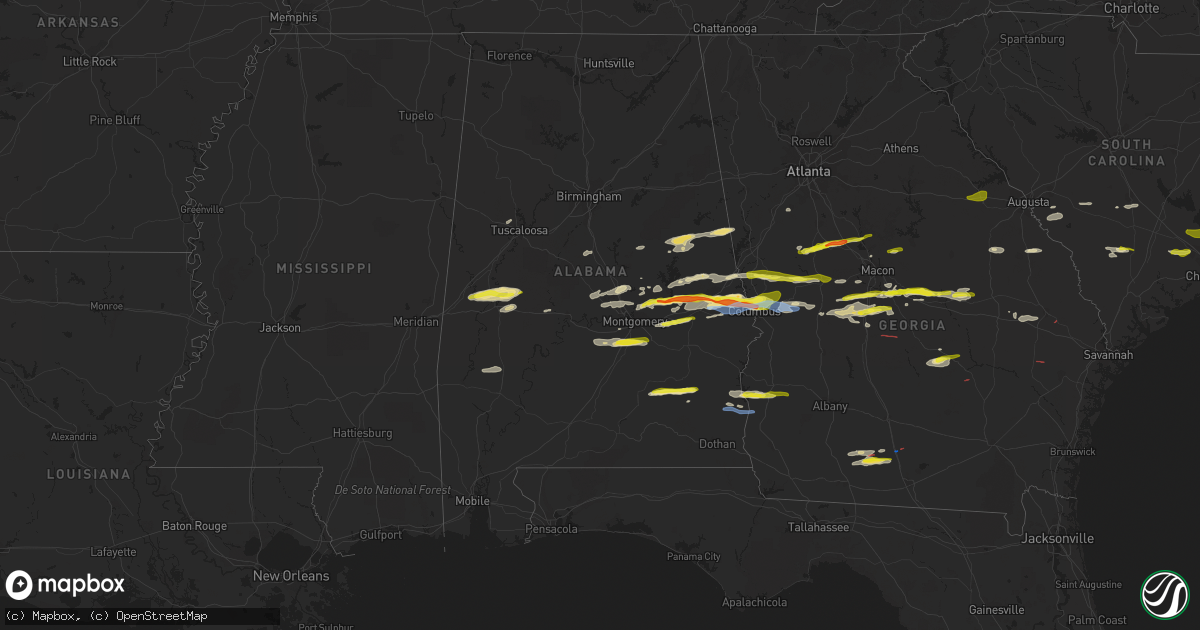
Hail Map in Alabama on December 30, 2021
Get this storm
December 30 map
$229
one time, instant access
Download today. No call, no setup
Keep the $229
Bought the map and want the full workflow? Apply the entire $229 to a subscription within 7 days. None of it is wasted.
Every map, not just this one
This buys you this map. Subscription and you get every map we run, in the markets you choose from a few cities to whole states to nationwide. Plus real-time alerts the moment a storm fires.
Contact data
Name, contact info, occupancy, even credit band for addresses in the footprint. You go from where it hit to who to call.
Become the source they trust
Unlimited branding weather history reports on demand. You already have the documented answer ready for the property owner, and you are the one who showed up with it.
Property data and RoofTrace estimates
Pull up any address you have got, its value and the exact code rules for that jurisdiction, straight from One Click Code. Then RoofTrace estimates the squares, pitch, and roof value, priced the way you price.
Storm reports in Alabama
Alabama
| Date | Description |
|---|---|
| 12/30/20214:23 PM CST | A few trees down north of abbeville. |
| 12/30/20212:47 PM CST | Golf ball size hail in smiths station. |
| 12/30/20212:28 PM CST | Silver dollar size hail in beauregard. |
| 12/30/20212:25 PM CST | Quarter size hail near lee road 54 and lee road 146..... |
| 12/30/20212:25 PM CST | Barn and residential roof damage on lee road 11. |
| 12/30/20212:10 PM CST | Tree down on county road 3310 and tree down on county road 3319. Hail of unknown size in brundidge. |
| 12/30/20212:07 PM CST | Multiple trees down highway 14 at mile marker 216. |
| 12/30/20212:05 PM CST | Quarter size hail in loachapoka. |
| 12/30/20211:48 PM CST | At least golf ball size hail near tallassee. |
| 12/30/20214:49 AM CST | At 1048 AM CST, a severe thunderstorm was located near Tishabee, or 9 miles northwest of Demopolis, moving east at 40 mph. HAZARD...60 mph wind gusts and quarter size hail. SOURCE...Radar indicated. IMPACT...Hail damage to vehicles is expected. Expect wind damage to roofs, siding, and trees. Locations impacted include... Demopolis, Greensboro, Forkland, Newbern, Greensboro Municipal Airport, Duffys Bend, Thornhill, Arcola, Tishabee, Belmont, Demopolis Lock And Dam, McDowell, Birdine, Cedarville and Laneville. |
| 12/30/20213:57 AM CST | At 957 AM CST, a severe thunderstorm was located over Jemison, moving east at 40 mph. HAZARD...60 mph wind gusts and penny size hail. SOURCE...Radar indicated. IMPACT...Expect damage to roofs, siding, and trees. Locations impacted include... Clanton, Jemison, Weogufka, Thorsby, Gap Of The Mountain, Strickland Crossroads, Lay Lake Dam, Unity, Marble Valley, Moriah, Lay Lake, Mitchell Lake, Minooka Park, Waxahatchee Creek, Highway 145 and CR 46, Paint Creek, I 65 Rest Area, Spring Creek and Lomax. |
| 12/30/20213:41 AM CST | At 940 AM CST, a severe thunderstorm was located over Goodwater, moving east at 35 mph. HAZARD...60 mph wind gusts and penny size hail. SOURCE...Radar indicated. IMPACT...Expect damage to roofs, siding, and trees. Locations impacted include... Alexander City, Goodwater, Kellyton, New Site, Goldville, Hillabee Creek, Bradford, Parkdale, Hatchet, Northern Lake Martin, Daviston, Cleveland Crossroads, Horseshoe Bend National Military Park, Hackneyville, Horseshoe Bend and Motley. |
| 12/29/202110:23 PM CST | At 423 PM EST, a severe thunderstorm was located over Christopher, or near Cusseta, moving east at 40 mph. HAZARD...60 mph wind gusts and quarter size hail. SOURCE...Radar indicated. IMPACT...Hail damage to vehicles is expected. Expect wind damage to roofs, siding, and trees. Locations impacted include... Buena Vista, Cusseta, Richland, Brantley, Seminole, Charles, Christopher, Jamestown/south Fort Benning, Brooklyn, Renfroe, Manta, Zellobee, Tazewell, Church Hill, Louvale and Providence Canyon State Park. |
| 12/29/20219:59 PM CST | At 359 PM EST, a severe thunderstorm was located over Highland Park, or over Columbus, moving east at 45 mph. HAZARD...Ping pong ball size hail and 60 mph wind gusts. SOURCE...Radar indicated. IMPACT...People and animals outdoors will be injured. Expect hail damage to roofs, siding, windows, and vehicles. Expect wind damage to roofs, siding, and trees. Locations impacted include... North Fort Benning, Upatoi, Saint Marys Hills, Edgewood, Highland Park, Sand Hill, Juniper, Vista Terrace, Box Springs, Kenwood, Eelbeck/West Fort Benning, Benning Hills, Avondale, Benning Park and Carter Acres. |
| 12/29/20219:45 PM CST | At 344 PM EST, a severe thunderstorm was located near Goat Rock Lake, or near Smiths, moving east at 30 mph. HAZARD...60 mph wind gusts and quarter size hail. SOURCE...Radar indicated. IMPACT...Hail damage to vehicles is expected. Expect wind damage to roofs, siding, and trees. Locations impacted include... Bibb City, Goat Rock Lake, Ellerslie, Flat Rock, Laurel Hills, Green Island Hills, Cataula, Columbus Metropolitan Airport, Midland, Mountain Hill, Bartletts Ferry Dam, Fortson, Mulberry Grove and Lake Harding. |
| 12/29/20219:15 PM CST | At 315 PM EST, a severe thunderstorm was located near River View, or near Valley, moving east at 40 mph. HAZARD...60 mph wind gusts and penny size hail. SOURCE...Radar indicated. IMPACT...Expect damage to roofs, siding, and trees. Locations impacted include... Hamilton, Greenville, Manchester, West Point, Pine Mountain, Warm Springs, F.d. Roosevelt State Park, Odessadale, Stovall, Mountain Hill, Big Springs, Durand, Jones Crossroads, Baughs Crossroads, Harris City and Whitesville-Pine Lake. |
| 12/29/20218:41 PM CST | At 241 PM CST, a severe thunderstorm was located over Bleecker, or near Smiths, moving east at 40 mph. HAZARD...Ping pong ball size hail and 60 mph wind gusts. SOURCE...Radar indicated. IMPACT...People and animals outdoors will be injured. Expect hail damage to roofs, siding, windows, and vehicles. Expect wind damage to roofs, siding, and trees. Locations impacted include... Phenix City, Smiths, Smiths Station, Ladonia, Bleecker, Monterey Heights, Ladonia Sports Complex, Phenix Drag Strip, Parkmanville and Bartletts Ferry Dam. |
| 12/29/20218:23 PM CST | At 223 PM CST, a severe thunderstorm was located near Liverpool, or near Milstead, moving east at 40 mph. HAZARD...60 mph wind gusts and half dollar size hail. SOURCE...Radar indicated. IMPACT...Hail damage to vehicles is expected. Expect wind damage to roofs, siding, and trees. Locations impacted include... Tuskegee, Milstead, Shorter, Franklin, Liverpool, Lake Tuskegee, Hardaway, Davisville, Society Hill, Warriorstand, Cross Keys, Creek Stand and Moton Field Municipal Airport. |
| 12/29/20218:16 PM CST | At 216 PM CST, a severe thunderstorm was located over Brundidge, moving east at 40 mph. HAZARD...Golf ball size hail and 60 mph wind gusts. SOURCE...Radar indicated. IMPACT...People and animals outdoors will be injured. Expect hail damage to roofs, siding, windows, and vehicles. Expect wind damage to roofs, siding, and trees. Locations impacted include... Clio, Louisville, Tyler Crossroads, Texasville, Gaino, Richards Crossroads, Blue Springs State Park, Millers Ford and Baker Hill. |
| 12/29/20217:57 PM CST | At 157 PM CST, a severe thunderstorm was located over Hayneville, moving east at 40 mph. HAZARD...60 mph wind gusts and quarter size hail. SOURCE...Radar indicated. IMPACT...Hail damage to vehicles is expected. Expect wind damage to roofs, siding, and trees. Locations impacted include... Southern Montgomery, Mosses, Hayneville, Pike Road, White Hall, Gordonville, Lowndesboro, Hyundai Motors Of Alabama, Beechwood, Hope Hull, Dannelly Field, Snowdoun, Sprague, Pinedale, Waugh, Pintlala, Woodcrest, Carters Hill, Letohatchee and Barachias. |
| 12/29/20217:51 PM CST | At 150 PM CST, a severe thunderstorm was located over Goshen, moving east at 40 mph. HAZARD...60 mph wind gusts and quarter size hail. SOURCE...Radar indicated. IMPACT...Hail damage to vehicles is expected. Expect wind damage to roofs, siding, and trees. Locations impacted include... Troy, Brundidge, Goshen, Banks, Antioch, Troy University, Brundidge Municipal Airport, Monticello, Mossy Grove and Henderson. |
| 12/29/20217:36 PM CST | At 135 PM CST, a severe thunderstorm was located near Eclectic, or 8 miles west of Tallassee, moving east at 40 mph. HAZARD...60 mph wind gusts and quarter size hail. SOURCE...Radar indicated. IMPACT...Hail damage to vehicles is expected. Expect wind damage to roofs, siding, and trees. Locations impacted include... Auburn, Tuskegee, Tallassee, Notasulga, Eclectic, Waverly, Liberty City, Reeves Airport, Tallapoosa City, Loachapoka, Claud, Yates Dam, I 85 Rest Area, Roxana, Reeltown and Yates Reservoir. |
All States Impacted by Hail Map on December 30, 2021
Cities Impacted by Hail Map on December 30, 2021
- Letohatchee, AL
- Hope Hull, AL
- Ramer, AL
- Hayneville, AL
- Montgomery, AL
- Byron, GA
- Greensboro, AL
- Boligee, AL
- Gallion, AL
- Forkland, AL
- Sawyerville, AL
- Livingston, AL
- Faunsdale, AL
- Wadley, AL
- Daviston, AL
- Cragford, AL
- Alexander City, AL
- Ashland, AL
- Smiths Station, AL
- Gray, GA
- Macon, GA
- Haddock, GA
- Prattville, AL
- Troy, AL
- Goshen, AL
- Brundidge, AL
- Clio, AL
- Ariton, AL
- Shorter, AL
- Hardaway, AL
- Tuskegee, AL
- Adrian, GA
- Wrightsville, GA
- East Dublin, GA
- Meansville, GA
- Danville, GA
- Dublin, GA
- Montrose, GA
- Jeffersonville, GA
- Irwinton, GA
- Dry Branch, GA
- Salem, AL
- Opelika, AL
- Fortson, GA
- Phenix City, AL
- Columbus, GA
- Auburn, AL
- Midland, GA
- Louisville, GA
- Camp Hill, AL
- Waverly, AL
- Dadeville, AL
- Deatsville, AL
- Marbury, AL
- Goodwater, AL
- Roanoke, AL
- Franklin, GA
- Woodland, GA
- Forsyth, GA
- The Rock, GA
- Barnesville, GA
- Molena, GA
- Zebulon, GA
- Milner, GA
- Moultrie, GA
- Pavo, GA
- Coolidge, GA
- Berlin, GA
- Barney, GA
- Adel, GA
- Perry, GA
- Warner Robins, GA
- Summerville, SC
- Wetumpka, AL
- Fort Gaines, GA
- Cuthbert, GA
- Coleman, GA
- Abbeville, AL
- Juliette, GA
- Concord, GA
- Thomaston, GA
- Jemison, AL
- Montevallo, AL
- Randolph, AL
- Eclectic, AL
- Shorterville, AL
- Tallassee, AL
- Reynolds, GA
- Rupert, GA
- Lodge, SC
- Islandton, SC
- McRae Helena, GA
- Milan, GA
- Notasulga, AL
- Auburn University, AL
- Cataula, GA
- Williston, SC
- Blackville, SC
- Coker, AL
- Marshallville, GA
- Hartsfield, GA
- Meigs, GA
- Metter, GA
- Lafayette, AL
- Fort Valley, GA
- Valley, AL
- Cusseta, AL
- Pike Road, AL
- Hamilton, GA
- Montezuma, GA
- Ideal, GA
- Kathleen, GA
- Cochran, GA
- Elko, GA
- Oglethorpe, GA
- Bonaire, GA
- Shiloh, GA
- Pine Mountain Valley, GA
- Pine Mountain, GA
- Twin City, GA
- Cecil, AL
- Tuskegee Institute, AL
- Morris, GA
- Eufaula, AL
- Waynesboro, GA
- Peachtree City, GA
- Sharpsburg, GA
- Box Springs, GA
- Sardis, GA
- Ehrhardt, SC
- Brunson, SC
- Hampton, SC
- Titus, AL
- Fairfax, SC
- Millbrook, AL
- Booth, AL
- Elmore, AL
- Autaugaville, AL
- Mauk, GA
- Junction City, GA
- Lizella, GA
- Centerville, GA
- Weogufka, AL
- Sylacauga, AL
- Ridgeville, SC
- Thomasville, AL
- Musella, GA
- Roberta, GA
- Jackson, SC
- Fort Benning, GA
- Orangeburg, SC
- Rowesville, SC
- Cordova, SC
- Norman Park, GA
- Louisville, AL
- Statesboro, GA
- Pulaski, GA
- Register, GA
- West Point, GA
- Talbotton, GA
- Waverly Hall, GA
- Marion Junction, AL
- Billingsley, AL
- Verbena, AL
- Jones, AL
- Butler, GA
- Minter, AL
- New Ellenton, SC
- Aiken, SC
- Cope, SC
- Equality, AL
- Northport, AL
- Kellyton, AL
- Union Springs, AL
- Newbern, AL
- Ellerslie, GA
- Upatoi, GA
- Newville, AL
- Williams, SC
- Ruffin, SC
- Pinopolis, SC
- Moncks Corner, SC
- Hazlehurst, GA
- Glennville, GA
- Hawkinsville, GA
- Brooklet, GA
- Sparks, GA
- Idaho Springs, CO
- Strasburg, CO
- Cripple Creek, CO
- Niwot, CO
- Calhan, CO
- Loveland, CO
- Louviers, CO
- Monument, CO
- Pine, CO
- Wheatland, WY
- Boulder, CO
- Golden, CO
- Glendo, WY
- Medicine Bow, WY
- Empire, CO
- Deer Trail, CO
- Estes Park, CO
- Berthoud, CO
- Parshall, CO
- Canon City, CO
- Evansville, WY
- Buffalo Creek, CO
- Johnstown, CO
- Lusk, WY
- Louisville, CO
- Drake, CO
- Glen Haven, CO
- Windsor, CO
- Usaf Academy, CO
- Bosler, WY
- Lafayette, CO
- Hartville, WY
- Dumont, CO
- Florissant, CO
- Douglas, WY
- Bairoil, WY
- Fountain, CO
- Livermore, CO
- Black Hawk, CO
- Woodland Park, CO
- Franktown, CO
- Silver Plume, CO
- Hanna, WY
- Cascade, CO
- Gillette, WY
- Castle Rock, CO
- Lingle, WY
- Tie Siding, WY
- Jay Em, WY
- Rock River, WY
- Alcova, WY
- Agate, CO
- Bailey, CO
- Divide, CO
- Buford, WY
- Indian Hills, CO
- Natrona, WY
- Rollinsville, CO
- Colorado Springs, CO
- Idledale, CO
- Casper, WY
- Granby, CO
- Elbert, CO
- Kiowa, CO
- Bellvue, CO
- Ward, CO
- Fraser, CO
- Longmont, CO
- Sedalia, CO
- Eldorado Springs, CO
- Wellington, CO
- Carr, CO
- Victor, CO
- Brighton, CO
- Guernsey, WY
- Lone Tree, CO
- Westminster, CO
- Larkspur, CO
- Shawnee, WY
- Nunn, CO
- Byers, CO
- Shoshoni, WY
- Centennial, WY
- Manitou Springs, CO
- Jeffrey City, WY
- Veteran, WY
- Georgetown, CO
- Littleton, CO
- Ramah, CO
- Ault, CO
- Grover, CO
- Aurora, CO
- Chugwater, WY
- Penrose, CO
- Greeley, CO
- Laporte, CO
- Parker, CO
- Fort Laramie, WY
- Palmer Lake, CO
- Fort Collins, CO
- Garrett, WY
- Arvada, CO
- Rawlins, WY
- Denver, CO
- Lyons, CO
- Glenrock, WY
- Erie, CO
- Red Feather Lakes, CO
- Walden, CO
- Allenspark, CO
- Manville, WY
- Lost Springs, WY
- Wheat Ridge, CO
- Laramie, WY
- Grand Lake, CO
- Nederland, CO
- Mills, WY
- Central City, CO
- Kittredge, CO
- Bennett, CO
- Evergreen, CO
- Lance Creek, WY
- Conifer, CO
- Winter Park, CO
- Granite Canon, WY
- Elk Mountain, WY
- Jamestown, CO
- Broomfield, CO
- Morrison, CO
- Dillon, CO
- Jelm, WY
- Peyton, CO
- Cheyenne, WY
- Yoder, WY
- Elizabeth, CO
- Green Mountain Falls, CO
- Wamsutter, WY
- Norwood, GA
- Thomson, GA
- Camak, GA
- Warrenton, GA
- Alamo, GA
- Monticello, GA
- Milledgeville, GA
- Culloden, GA
- Shellman, GA
- Kite, GA


