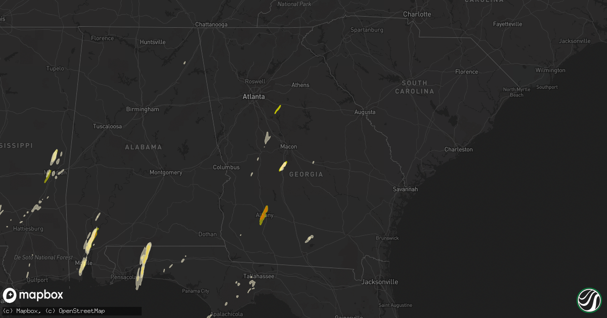
Hail Map in Georgia on December 23, 2014
Get this storm
December 23 map
$229
one time, instant access
Download today. No call, no setup
Keep the $229
Bought the map and want the full workflow? Apply the entire $229 to a subscription within 7 days. None of it is wasted.
Every map, not just this one
This buys you this map. Subscription and you get every map we run, in the markets you choose from a few cities to whole states to nationwide. Plus real-time alerts the moment a storm fires.
Contact data
Name, contact info, occupancy, even credit band for addresses in the footprint. You go from where it hit to who to call.
Become the source they trust
Unlimited branding weather history reports on demand. You already have the documented answer ready for the property owner, and you are the one who showed up with it.
Property data and RoofTrace estimates
Pull up any address you have got, its value and the exact code rules for that jurisdiction, straight from One Click Code. Then RoofTrace estimates the squares, pitch, and roof value, priced the way you price.
Storm reports in Georgia
Georgia
| Date | Description |
|---|---|
| 12/23/20141:00 PM CST | Multiple reports have been received from the whitfield county em from an area sw of dalton to just south of town. The following locations had thunderstorm wind damage w |
| 12/23/20141:00 PM CST | 911 center reported many trees down county wide. In addition there was a tree down on a trailer near elm street and a roof was blown off on 3rd avenue. |
| 12/23/201412:58 PM CST | Tornado touched down. Trees down. |
| 12/23/201412:48 PM CST | Tree down on a structure |
| 12/23/201412:47 PM CST | Numerous trees down ssw of dalton. Some trees fell on power lines. |
| 12/23/201412:29 PM CST | Several trees and powerlines down on floyd springs road. Ga power notified |
| 12/23/201412:15 PM CST | Emergency manager reports trees and powerlines down northeast of gore. |
| 12/23/20149:00 AM CST | Several employees of hendersons grocery and shell station near highway 36 reported quarter size hail. |
| 12/23/20146:15 AM CST | 911 call center recieved report of quarter size hail in perry. |
Cities Impacted by Hail Map on December 23, 2014
- Eglin Afb, FL
- Navarre, FL
- Wing, AL
- Holt, FL
- Baker, FL
- Mobile, AL
- Dry Creek, LA
- Deridder, LA
- Sugartown, LA
- Pitkin, LA
- Crawfordville, FL
- Woodworth, LA
- Ferriday, LA
- Jonesville, LA
- Gilbert, LA
- Clayton, LA
- Sicily Island, LA
- Stockton, AL
- Little River, AL
- Jackson, AL
- Liberty, MS
- Centreville, MS
- Perry, GA
- Fort Valley, GA
- Kathleen, GA
- Singer, LA
- Amite, LA
- Plaucheville, LA
- Baton Rouge, LA
- Vidalia, LA
- Natchez, MS
- Saint Francisville, LA
- Woodville, MS
- Addis, LA
- Rayne, LA
- Kaplan, LA
- Waterproof, LA
- Pineville, LA
- Lecompte, LA
- Alexandria, LA
- Effie, LA
- Oakdale, LA
- Forest Hill, LA
- Elmer, LA
- Center Point, LA
- Glenmora, LA
- Deville, LA
- Bogue Chitto, MS
- Brookhaven, MS
- Greenwell Springs, LA
- Gloster, MS
- Ventress, LA
- Oscar, LA
- Jackson, LA
- Jarreau, LA
- Orange, TX
- Vidor, TX
- Buna, TX
- Marksville, LA
- Moreauville, LA
- Eunice, LA
- Abbeville, LA
- Maurice, LA
- Lafayette, LA
- Duson, LA
- Morgan City, LA
- Paulina, LA
- Sopchoppy, FL
- Morse, LA
- Gueydan, LA
- Meridian, MS
- Monterey, LA
- Acme, LA
- Simmesport, LA
- Monticello, MS
- Ponce De Leon, FL
- Westville, FL
- Starks, LA
- Grant, LA
- Merryville, LA
- Longville, LA
- Washington, LA
- Carencro, LA
- Sunset, LA
- Crowley, LA
- Scott, LA
- Opelousas, LA
- Church Point, LA
- Kentwood, LA
- Clinton, LA
- Greensburg, LA
- Denham Springs, LA
- Pine Grove, LA
- Port Allen, LA
- Mount Hermon, LA
- Shubuta, MS
- Batchelor, LA
- Tallahassee, FL
- Warner Robins, GA
- Silsbee, TX
- Summit, MS
- Jayess, MS
- Mccomb, MS
- Tylertown, MS
- Enterprise, MS
- De Kalb, MS
- Bailey, MS
- Daleville, MS
- Pride, LA
- Port Barre, LA
- Arnaudville, LA
- Norwood, LA
- Wilson, LA
- Defuniak Springs, FL
- Niceville, FL
- Batson, TX
- Plattenville, LA
- Napoleonville, LA
- Belle Rose, LA
- Yatesville, GA
- Barnesville, GA
- Forsyth, GA
- Culloden, GA
- Pinola, MS
- Evergreen, LA
- Cottonport, LA
- Sumrall, MS
- Newhebron, MS
- Magnolia, MS
- Theodore, AL
- Creola, AL
- Axis, AL
- Beaumont, TX
- Elizabeth, LA
- Deweyville, TX
- Sontag, MS
- Lakeland, GA
- Ray City, GA
- Nashville, GA
- Franklinton, LA
- Ethel, LA
- Saint James, LA
- Saint Martinville, LA
- Lakeland, LA
- Zachary, LA
- New Roads, LA
- Livonia, LA
- Lottie, LA
- Maringouin, LA
- Grove Hill, AL
- Erath, LA
- Smithdale, MS
- Wesson, MS
- Silver Creek, MS
- Osyka, MS
- Oak Vale, MS
- Plaquemine, LA
- Call, TX
- Sunshine, LA
- Saint Gabriel, LA
- Butler, GA
- Branch, LA
- Union Church, MS
- McCall Creek, MS
- Saucier, MS
- Perkinston, MS
- Kountze, TX
- Jeanerette, LA
- Hosford, FL
- Palmetto, LA
- Heidelberg, MS
- Meadville, MS
- Breaux Bridge, LA
- Slaughter, LA
- Bude, MS
- Fordoche, LA
- Crosby, MS
- Andalusia, AL
- Milton, FL
- Mary Esther, FL
- Independence, LA
- Albany, LA
- Tickfaw, LA
- Holden, LA
- Eastpoint, FL
- Mendenhall, MS
- Roseland, LA
- Lauderdale, MS
- Prentiss, MS
- Morrow, LA
- Mansura, LA
- Hazlehurst, MS
- Ruth, MS
- Laurel, MS
- Hattiesburg, MS
- Seminary, MS
- Porterville, MS
- New Iberia, LA
- Broussard, LA
- Youngsville, LA
- Dawson, AL
- Collinsville, AL
- Kirbyville, TX
- Buena Vista, GA
- Fluker, LA
- Walker, LA
- Dudley, GA
- Columbia, MS
- Chunchula, AL
- Mount Vernon, AL
- Bon Wier, TX
- McIntosh, AL
- Ponchatoula, LA
- Springfield, LA
- Egan, LA
- White Castle, LA
- Lettsworth, LA
- Angola, LA
- Jennings, LA
- Lake Arthur, LA
- Baker, LA
- Ellisville, MS
- Garyville, LA
- Maurepas, LA
- Newellton, LA
- Colquitt, GA
- Toomsuba, MS
- Port Saint Joe, FL
- Gulfport, MS
- Pass Christian, MS
- Cameron, LA
- Creole, LA
- Wiggins, MS
- Wisner, LA
- Rose Hill, MS
- Covington, GA
- Bonaire, GA
- Albany, GA
- Leesburg, GA
- Newton, GA


