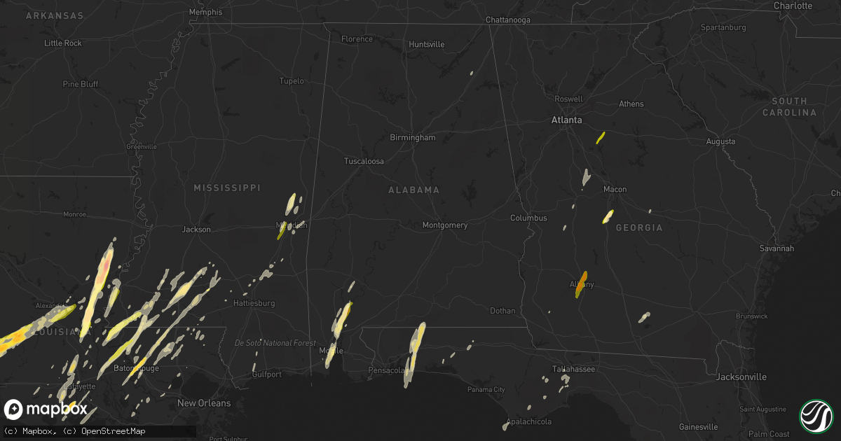
Hail Map in Alabama on December 23, 2014
Get this storm
December 23 map
$229
one time, instant access
Download today. No call, no setup
Keep the $229
Bought the map and want the full workflow? Apply the entire $229 to a subscription within 7 days. None of it is wasted.
Every map, not just this one
This buys you this map. Subscription and you get every map we run, in the markets you choose from a few cities to whole states to nationwide. Plus real-time alerts the moment a storm fires.
Contact data
Name, contact info, occupancy, even credit band for addresses in the footprint. You go from where it hit to who to call.
Become the source they trust
Unlimited branding weather history reports on demand. You already have the documented answer ready for the property owner, and you are the one who showed up with it.
Property data and RoofTrace estimates
Pull up any address you have got, its value and the exact code rules for that jurisdiction, straight from One Click Code. Then RoofTrace estimates the squares, pitch, and roof value, priced the way you price.
Storm reports in Alabama
Alabama
| Date | Description |
|---|---|
| 12/23/20145:35 PM CST | 5 trees down along highway 25. Reported via social media. |
| 12/23/20145:29 PM CST | Trees down near county 29 and highway 25. Time estimated from radar. |
| 12/23/20144:45 PM CST | Large tree limbs/branches down |
| 12/23/20144:41 PM CST | Trees down near dansby rd and hwy 10 |
| 12/23/20144:36 PM CST | Trees down near the intersection of pleasant hill rd and hwy 17 |
| 12/23/20144:31 PM CST | Trees and powerlines down 1 mile west of gilfield church. |
| 12/23/20141:47 PM CST | Quarter size hail reported in pleasant hill |
| 12/23/201411:25 AM CST | Powerlines down near centre hwy in the ballplay community. Time estimated from radar. |
| 12/23/201411:18 AM CST | Tree down on house on marguierite st. No known injuries at this time. Time estimated from radar. |
| 12/23/20148:10 AM CST | Quarter size hail reported in the town of carlton |
| 12/22/20148:56 PM CST | One tree uprooted with many scattered limbs down. |
| 12/22/20148:30 PM CST | Uprooted sweetbay magnolia tree blocking the intersection of highway 32 and highway 83 south. |
| 12/22/20147:25 PM CST | One tree down on powerline near mcdonough st and cramer ave. Winds estimated 50 mph. |
| 12/22/20146:35 PM CST | Trees and powerlines down along us31 between clanton and verbena. |
| 12/22/20146:19 PM CST | Trees down along highway 191 near jemison |
Cities Impacted by Hail Map on December 23, 2014
- Eglin Afb, FL
- Navarre, FL
- Wing, AL
- Holt, FL
- Baker, FL
- Mobile, AL
- Dry Creek, LA
- Deridder, LA
- Sugartown, LA
- Pitkin, LA
- Crawfordville, FL
- Woodworth, LA
- Ferriday, LA
- Jonesville, LA
- Gilbert, LA
- Clayton, LA
- Sicily Island, LA
- Stockton, AL
- Little River, AL
- Jackson, AL
- Liberty, MS
- Centreville, MS
- Perry, GA
- Fort Valley, GA
- Kathleen, GA
- Singer, LA
- Amite, LA
- Plaucheville, LA
- Baton Rouge, LA
- Vidalia, LA
- Natchez, MS
- Saint Francisville, LA
- Woodville, MS
- Addis, LA
- Rayne, LA
- Kaplan, LA
- Waterproof, LA
- Pineville, LA
- Lecompte, LA
- Alexandria, LA
- Effie, LA
- Oakdale, LA
- Forest Hill, LA
- Elmer, LA
- Center Point, LA
- Glenmora, LA
- Deville, LA
- Bogue Chitto, MS
- Brookhaven, MS
- Greenwell Springs, LA
- Gloster, MS
- Ventress, LA
- Oscar, LA
- Jackson, LA
- Jarreau, LA
- Orange, TX
- Vidor, TX
- Buna, TX
- Marksville, LA
- Moreauville, LA
- Eunice, LA
- Abbeville, LA
- Maurice, LA
- Lafayette, LA
- Duson, LA
- Morgan City, LA
- Paulina, LA
- Sopchoppy, FL
- Morse, LA
- Gueydan, LA
- Meridian, MS
- Monterey, LA
- Acme, LA
- Simmesport, LA
- Monticello, MS
- Ponce De Leon, FL
- Westville, FL
- Starks, LA
- Grant, LA
- Merryville, LA
- Longville, LA
- Washington, LA
- Carencro, LA
- Sunset, LA
- Crowley, LA
- Scott, LA
- Opelousas, LA
- Church Point, LA
- Kentwood, LA
- Clinton, LA
- Greensburg, LA
- Denham Springs, LA
- Pine Grove, LA
- Port Allen, LA
- Mount Hermon, LA
- Shubuta, MS
- Batchelor, LA
- Tallahassee, FL
- Warner Robins, GA
- Silsbee, TX
- Summit, MS
- Jayess, MS
- Mccomb, MS
- Tylertown, MS
- Enterprise, MS
- De Kalb, MS
- Bailey, MS
- Daleville, MS
- Pride, LA
- Port Barre, LA
- Arnaudville, LA
- Norwood, LA
- Wilson, LA
- Defuniak Springs, FL
- Niceville, FL
- Batson, TX
- Plattenville, LA
- Napoleonville, LA
- Belle Rose, LA
- Yatesville, GA
- Barnesville, GA
- Forsyth, GA
- Culloden, GA
- Pinola, MS
- Evergreen, LA
- Cottonport, LA
- Sumrall, MS
- Newhebron, MS
- Magnolia, MS
- Theodore, AL
- Creola, AL
- Axis, AL
- Beaumont, TX
- Elizabeth, LA
- Deweyville, TX
- Sontag, MS
- Lakeland, GA
- Ray City, GA
- Nashville, GA
- Franklinton, LA
- Ethel, LA
- Saint James, LA
- Saint Martinville, LA
- Lakeland, LA
- Zachary, LA
- New Roads, LA
- Livonia, LA
- Lottie, LA
- Maringouin, LA
- Grove Hill, AL
- Erath, LA
- Smithdale, MS
- Wesson, MS
- Silver Creek, MS
- Osyka, MS
- Oak Vale, MS
- Plaquemine, LA
- Call, TX
- Sunshine, LA
- Saint Gabriel, LA
- Butler, GA
- Branch, LA
- Union Church, MS
- McCall Creek, MS
- Saucier, MS
- Perkinston, MS
- Kountze, TX
- Jeanerette, LA
- Hosford, FL
- Palmetto, LA
- Heidelberg, MS
- Meadville, MS
- Breaux Bridge, LA
- Slaughter, LA
- Bude, MS
- Fordoche, LA
- Crosby, MS
- Andalusia, AL
- Milton, FL
- Mary Esther, FL
- Independence, LA
- Albany, LA
- Tickfaw, LA
- Holden, LA
- Eastpoint, FL
- Mendenhall, MS
- Roseland, LA
- Lauderdale, MS
- Prentiss, MS
- Morrow, LA
- Mansura, LA
- Hazlehurst, MS
- Ruth, MS
- Laurel, MS
- Hattiesburg, MS
- Seminary, MS
- Porterville, MS
- New Iberia, LA
- Broussard, LA
- Youngsville, LA
- Dawson, AL
- Collinsville, AL
- Kirbyville, TX
- Buena Vista, GA
- Fluker, LA
- Walker, LA
- Dudley, GA
- Columbia, MS
- Chunchula, AL
- Mount Vernon, AL
- Bon Wier, TX
- McIntosh, AL
- Ponchatoula, LA
- Springfield, LA
- Egan, LA
- White Castle, LA
- Lettsworth, LA
- Angola, LA
- Jennings, LA
- Lake Arthur, LA
- Baker, LA
- Ellisville, MS
- Garyville, LA
- Maurepas, LA
- Newellton, LA
- Colquitt, GA
- Toomsuba, MS
- Port Saint Joe, FL
- Gulfport, MS
- Pass Christian, MS
- Cameron, LA
- Creole, LA
- Wiggins, MS
- Wisner, LA
- Rose Hill, MS
- Covington, GA
- Bonaire, GA
- Albany, GA
- Leesburg, GA
- Newton, GA


