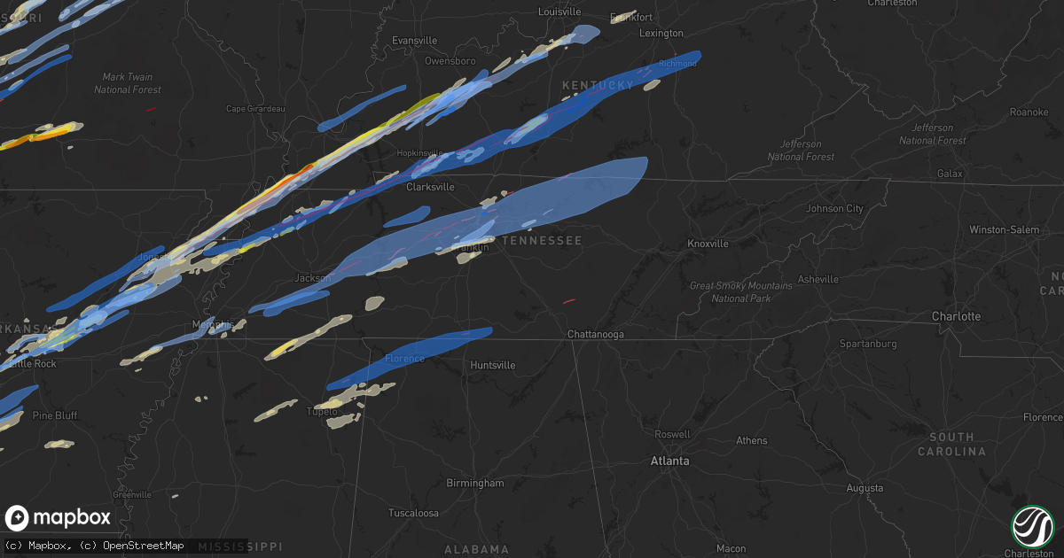
Hail Map in Tennessee on December 10, 2021
Get this storm
December 10 map
$229
one time, instant access
Download today. No call, no setup
Keep the $229
Bought the map and want the full workflow? Apply the entire $229 to a subscription within 7 days. None of it is wasted.
Every map, not just this one
This buys you this map. Subscription and you get every map we run, in the markets you choose from a few cities to whole states to nationwide. Plus real-time alerts the moment a storm fires.
Contact data
Name, contact info, occupancy, even credit band for addresses in the footprint. You go from where it hit to who to call.
Become the source they trust
Unlimited branding weather history reports on demand. You already have the documented answer ready for the property owner, and you are the one who showed up with it.
Property data and RoofTrace estimates
Pull up any address you have got, its value and the exact code rules for that jurisdiction, straight from One Click Code. Then RoofTrace estimates the squares, pitch, and roof value, priced the way you price.
Storm reports in Tennessee
Tennessee
| Date | Description |
|---|---|
| 12/10/20215:35 AM CST | Few trees down just east of the park. |
| 12/10/20215:20 AM CST | At 1119 PM CST, a severe thunderstorm was located near Burdette, or near Luxora, moving northeast at 50 mph. HAZARD...60 mph wind gusts and quarter size hail. SOURCE...Radar indicated. IMPACT...Hail damage to vehicles is expected. Expect wind damage to roofs, siding, and trees. Locations impacted include... Dyersburg, Blytheville, Luxora, Newbern, Halls, Burdette, Bradleytown, Heloise, Unionville, Miston, Ashport, Edith, Fowlkes, Bonicord, O'Donnell Bend, Tomato, Jenkinsville, Maxey, Rohoboth and Broadmoor. |
| 12/10/20215:00 AM CST | Several trees were blown down across lawrence county. |
| 12/10/20214:46 AM CST | Corrects previous tstm wnd dmg report from 4 ssw dickson. Numerous trees damaged on 200 block of murrell road in dickson. Facebook report. |
| 12/10/20214:46 AM CST | Large tree down near high school in byrdstown... Tn. |
| 12/10/20214:45 AM CST | Trees and power lines were blown down in and around livingston and rickman. |
| 12/10/20214:30 AM CST | Tree fell across hwy 136. |
| 12/10/20214:22 AM CST | Trees down near old clementsville road... Damage to chicken houses. |
| 12/10/20214:20 AM CST | A few homes damaged. Power lines... Trees... And barns destroyed along hwy 52 between hill top road and clementsville ky road. |
| 12/10/20214:16 AM CST | 40 x 60 ft pole barn destroyed in gainesboro. |
| 12/10/20214:12 AM CST | Trees down in multiple areas in jackson county with many down in the granville area. |
| 12/10/20214:05 AM CST | Trees uprooted and twisted on horseshoe bend in elmwood. Facebook report. |
| 12/10/20214:04 AM CST | Multiple trees down and structural damage to a few houses and barns. Partial roof taken off building near hwy 70. |
| 12/10/20213:54 AM CST | Tree fell on car on rome road in riddleton. Twitter. |
| 12/10/20213:48 AM CST | Smyrna airport awos measured a peak wind gust of 51 knots / 59 mph. |
| 12/10/20213:38 AM CST | Welds broken on 3 metal signs where cemented into concrete at mt. Juliet high school. Structural engineer estimated winds in excess of 70+ mph. |
| 12/10/20213:37 AM CST | Tree fell on house on george thomas drive. Report and photos from twitter. |
| 12/10/20213:36 AM CST | Trees were blown down including a tree on a house on pearcy street. |
| 12/10/20213:35 AM CST | Due to high winds... Multiple streets were blocked by downed trees and power lines. |
| 12/10/20213:35 AM CST | Trees down on jones lane in extreme north mount juliet. |
| 12/10/20213:34 AM CST | Minor home damage... 24 inch diameter trees snapped and uprooted and damages to fences on thornwood court. |
| 12/10/20213:34 AM CST | Several large trees uprooted on at cumberland hills near lake park drive in hendersonville. Twitter report. |
| 12/10/20213:33 AM CST | Roof blown off of home on private drive. #tspotter report and photos from twitter. |
| 12/10/20213:32 AM CST | Docks destroyed and pontoon boat blown over at cherokee road near private drive. Twitter report. |
| 12/10/20213:31 AM CST | Mesonet station ew9547 brentwood. |
| 12/10/20213:30 AM CST | Trees and power lines were blown down across nashville area. Around 80...000 customers lost power. |
| 12/10/20213:30 AM CST | Numerous trees and power lines were blown down. Some structure damage was also reported. |
| 12/10/20213:28 AM CST | Nashville intl airport asos measured a peak wind gust of 78 mph. This is the third highest wind gust ever measured at the airport. |
| 12/10/20213:27 AM CST | Damaged outbuildings... Uprooted trees... And minor home damage on stewarts ferry pike near south new hope road. |
| 12/10/20213:25 AM CST | At 925 PM CST, a severe thunderstorm was located near Cherry Valley, or 10 miles southeast of Harrisburg, moving east at 45 mph. HAZARD...70 mph wind gusts and quarter size hail. SOURCE...Radar indicated. IMPACT...Hail damage to vehicles is expected. Expect considerable tree damage. Wind damage is also likely to mobile homes, roofs, and outbuildings. Locations impacted include... Wynne, Marked Tree, Earle, Parkin, Wilson, Tyronza, Cherry Valley, Joiner, Dyess, Hickory Ridge, Gilmore, Bassett, Jericho, Marie, Fair Oaks, Vanndale, Turrell, Clarkedale, Birdsong and Three Forks. |
| 12/10/20213:23 AM CST | Several power poles snapped in crieve hall along brentview hills drive near stallworth drive. Twitter report. |
| 12/10/20213:20 AM CST | Numerous trees and power lines were blown down. |
| 12/10/20213:20 AM CST | Trees... Power lines... And signs were blown down along clarksville pike. |
| 12/10/20213:18 AM CST | One-half dozen trees snapped near concord road and wilson pike. |
| 12/10/20213:18 AM CST | Twitter report of trees down in bells bend area. Time estimated via radar. |
| 12/10/20213:15 AM CST | Trees and power lines were blown down and structure damage was reported along old hickory blvd and tidwell hollow rd. |
| 12/10/20213:05 AM CST | Multiple trees were blown down on cars on indian springs rd and pond creek road. |
| 12/10/20213:00 AM CST | Significant structure damage was reported to homes and businesses. Numerous trees and power lines were blown down... Blocking roads throughout kingston springs. |
| 12/10/20212:46 AM CST | Corrects previous tstm wnd dmg report from 4 ssw dickson. Corrects previous tstm wnd dmg report from 4 ssw dickson. Numerous trees damaged on 200 block of murrell road |
| 12/10/20212:45 AM CST | At least 12 structures on murrell rad and crossroad cowarn road had heavy damage. Some people were trapped in the structures. |
| 12/10/20212:20 AM CST | Trees down on power lines. Power outages reported throughout perry county. |
| 12/10/20212:15 AM CST | Numerous trees were blown down... Blocking the road. |
| 12/10/20212:10 AM CST | A local report indicates 60 MPH wind near PARSONS |
| 12/10/20211:45 AM CST | Significant structural damage to homes and mobile homes near the timberlake industrial park. Trees were uprooted. |
| 12/10/20211:45 AM CST | Significant st ky 3741 8540 report from mping: homes/buildings completely destroyed. |
| 12/10/20211:45 AM CST | Widespread damage to trees and powerlines along highway 412 just west of lexington. |
| 12/10/20211:20 AM CST | Tree down on fence in oakfield... As well as siding blown off of parts of the house. |
| 12/10/20211:15 AM CST | Utility pole down on castle heights dr. |
| 12/10/20211:00 AM CST | Tree down on car on greer st in orange mound. |
| 12/10/202112:31 AM CST | Tree on house on e. Shelby drive... |
| 12/10/202112:24 AM CST | Clarksville outlaw field asos measured a peak wind gust of 53 knots / 61 mph. |
| 12/10/202112:14 AM CST | Emergency operations has received reports of damage and injuries on link road and walker ridge. 700 power outages were reported across northern stewart county. |
| 12/10/202112:09 AM CST | Collapsed roof on structure on lowell ave. |
| 12/10/202112:07 AM CST | Tree down on house on s. Greer st. |
| 12/10/202112:05 AM CST | Tree down on home on spottswood ave |
| 12/10/202112:05 AM CST | *** 1 inj *** multiple trees and power lines down. Multiple structures damaged concentrated in the 2300 block of highway 120 in big rock. 1 minor injury reported. |
| 12/10/202112:01 AM CST | Tree down across atla vista avenue. |
| 12/10/202112:01 AM CST | Several homes damaged or destroyed on bumpus mills road. |
| 12/10/202112:00 AM CST | *** 1 inj *** multiple trees and powerlines were blown down. Local responders reported multiple structures were damaged mainly in the 2300 block of highway 120 in big r |
| 12/09/202111:59 PM CST | Damage to property on sleepy ridge. |
| 12/09/202111:56 PM CST | House damaged on stimson road. |
| 12/09/202111:08 PM CST | *** 1 inj *** tornado with at least 1 person injured in dresden with 6 buildings damaged. |
| 12/09/202110:55 PM CST | Quarter sized hail near dyer... Tennessee... With about 30-40 mph winds. |
| 12/09/202110:47 PM CST | Report of multiple power lines down... Trees down... And impassable roads. |
| 12/09/202110:37 PM CST | Tornadic debris signature noted northeast of newbern. |
| 12/09/20218:44 PM CST | Em reported damage to 25-30 homes. On the gibson side of kenton. |
| 12/09/20218:38 PM CST | Samburg fire station took direct hit with people trapped in damage. |
All States Impacted by Hail Map on December 10, 2021
Cities Impacted by Hail Map on December 10, 2021
- Texarkana, TX
- Griffithville, AR
- Searcy, AR
- Urbana, MO
- Tunas, MO
- Macks Creek, MO
- Avery, TX
- Clarksville, TX
- De Kalb, TX
- Foreman, AR
- Haworth, OK
- Willow Springs, MO
- Cabool, MO
- Memphis, TN
- Branch, AR
- Bogata, TX
- Columbia, MO
- Hartsburg, MO
- Ashland, MO
- Prairie Grove, AR
- Summers, AR
- Lincoln, AR
- Talco, TX
- Tiptonville, TN
- Meta, MO
- Linn Creek, MO
- Brumley, MO
- Camdenton, MO
- Kaiser, MO
- Henley, MO
- Westphalia, MO
- Ulman, MO
- Montreal, MO
- Jefferson City, MO
- Eldon, MO
- Tuscumbia, MO
- Iberia, MO
- Saint Elizabeth, MO
- Eugene, MO
- Saint Thomas, MO
- Nashville, AR
- Ozan, AR
- McCaskill, AR
- Murfreesboro, AR
- Ashdown, AR
- Arkadelphia, AR
- Columbus, AR
- Mineral Springs, AR
- Prescott, AR
- Blevins, AR
- Antoine, AR
- Saratoga, AR
- Lockesburg, AR
- Okolona, AR
- Delight, AR
- Shepherdsville, KY
- Lebanon Junction, KY
- West Point, KY
- Seligman, MO
- Mountain Pine, AR
- Hot Springs National Park, AR
- Hot Springs Village, AR
- Manila, AR
- Finley, TN
- Island, KY
- Luxora, AR
- Brookland, AR
- Leachville, AR
- Union City, TN
- Princeton, KY
- Eddyville, KY
- Livermore, KY
- Portageville, MO
- Blytheville, AR
- Caraway, AR
- Ridgely, TN
- Troy, TN
- Harrisburg, AR
- Bremen, KY
- Dyersburg, TN
- Mortons Gap, KY
- Etowah, AR
- Osceola, AR
- Hornersville, MO
- Whitesville, KY
- Hickman, KY
- Lake City, AR
- Beedeville, AR
- Earlington, KY
- Hartford, KY
- Benton, KY
- Hornbeak, TN
- Keiser, AR
- Gobler, MO
- Cherry Valley, AR
- Hayti, MO
- Fancy Farm, KY
- Halls, TN
- Fulton, KY
- Augusta, AR
- Centertown, KY
- Kennett, MO
- Cash, AR
- Fisher, AR
- Wingo, KY
- Gilbertsville, KY
- Weiner, AR
- Calvert City, KY
- Trumann, AR
- Black Oak, AR
- Dawson Springs, KY
- Hickory, KY
- Jonesboro, AR
- Kuttawa, KY
- Monette, AR
- Hickory Ridge, AR
- Madisonville, KY
- Steele, MO
- White Plains, KY
- Symsonia, KY
- Bragg City, MO
- Caruthersville, MO
- Mayfield, KY
- Sacramento, KY
- Grand Rivers, KY
- McCrory, AR
- Bay, AR
- Newport, AR
- Arbyrd, MO
- Lepanto, AR
- Amagon, AR
- Clinton, KY
- Utica, KY
- Pea Ridge, AR
- Henderson, TX
- Jacksonville, AR
- Little Rock Air Force Base, AR
- Deport, TX
- Tupelo, MS
- Mooreville, MS
- Saltillo, MS
- Dover, TN
- Cadiz, KY
- Bumpus Mills, TN
- Cabot, AR
- Sherwood, AR
- Ward, AR
- Lonoke, AR
- Beebe, AR
- McRae, AR
- Austin, AR
- Long Lane, MO
- Moro, AR
- Forrest City, AR
- Brinkley, AR
- Haynes, AR
- Clarendon, AR
- Marianna, AR
- Gallatin, TN
- Leslie, MO
- Farmersville, TX
- Nevada, TX
- Greenville, IL
- Smithboro, IL
- Huntsville, AR
- Red Bay, AL
- Newbern, TN
- Dyer, TN
- Dennis, MS
- Marietta, MS
- Mantachie, MS
- Belden, MS
- New Site, MS
- Guntown, MS
- Belmont, MS
- Baldwyn, MS
- Vina, AL
- Fulton, MS
- Russellville, AL
- Golden, MS
- Shelbyville, KY
- Bagdad, KY
- Waddy, KY
- Frankfort, KY
- Gentry, AR
- Twin Oaks, OK
- Colcord, OK
- Bella Vista, AR
- Oaks, OK
- Kansas, OK
- Gravette, AR
- Decatur, AR
- Bentonville, AR
- Centerton, AR
- Hiwasse, AR
- Garfield, AR
- Bath Springs, TN
- Waynesboro, TN
- Savannah, TN
- Olivehill, TN
- Clifton, TN
- Gleason, TN
- Puryear, TN
- Dresden, TN
- Paris, TN
- Cottage Grove, TN
- Mountain Grove, MO
- Lamar, MS
- Michigan City, MS
- Ashland, MS
- Lebanon, MO
- Lancaster, KY
- Crab Orchard, KY
- Stanford, KY
- Trenton, KY
- Fort Campbell, KY
- Oak Grove, KY
- Pembroke, KY
- Marthasville, MO
- New Haven, MO
- Gerald, MO
- Washington, MO
- Rogersville, MO
- Marshfield, MO
- Strafford, MO
- Thompsons Station, TN
- Franklin, TN
- Brownstown, IL
- Saint Elmo, IL
- Gurdon, AR
- Kenton, TN
- Trimble, TN
- Owensville, MO
- Mountain View, MO
- Vanzant, MO
- Summersville, MO
- Elk Creek, MO
- Yukon, MO
- Drury, MO
- Nettleton, MS
- Eldridge, MO
- Plantersville, MS
- Amory, MS
- Park City, KY
- Smiths Grove, KY
- Cave City, KY
- Horse Cave, KY
- Watertown, TN
- Gordonsville, TN
- Lebanon, TN
- Sheridan, AR
- Washington, AR
- Leola, AR
- Carthage, AR
- Emmet, AR
- Hope, AR
- Sparkman, AR
- Elkton, KY
- Hopkinsville, KY
- Guthrie, KY
- Mammoth Cave, KY
- Brownsville, KY
- Oakland, KY
- Rocky Hill, KY
- Bowling Green, KY
- Star City, AR
- Rison, AR
- Auburn, KY
- Russellville, KY
- Olmstead, KY
- Lewisburg, KY
- Texarkana, AR
- Subiaco, AR
- Paris, AR
- New Blaine, AR
- Scranton, AR
- Falls Of Rough, KY
- Harned, KY
- Garfield, KY
- Hardinsburg, KY
- Paint Lick, KY
- Miller, MO
- Ash Grove, MO
- Everton, MO
- Caddo Mills, TX
- Guston, KY
- Holly Springs, MS
- Falkner, MS
- Walnut, MS
- Parsons, TN
- Lobelville, TN
- Centerville, TN
- Linden, TN
- Middleton, TN
- Ramer, TN
- Stantonville, TN
- Pocahontas, TN
- Tiplersville, MS
- Adamsville, TN
- Selmer, TN
- Sulphur Bluff, TX
- Lake Creek, TX
- Cooper, TX
- Effingham, IL
- Altamont, IL
- Chesterfield, MO
- Saint Louis, MO
- La Vergne, TN
- Paron, AR
- Walnut Grove, MO
- South Greenfield, MO
- Greenfield, MO
- Lockwood, MO
- Vienna, MO
- Ava, MO
- Beaufort, MO
- Royse City, TX
- Celeste, TX
- Lavon, TX
- Greenville, TX
- Rockwall, TX
- Oxford, MS
- Paris, MS
- Pontotoc, MS
- Water Valley, MS
- Thaxton, MS
- Ecru, MS
- Ballwin, MO
- Cuba, MO
- Rosebud, MO
- Pomona, MO
- El Paso, AR
- Maryland Heights, MO
- Granite City, IL
- Pacific, MO
- East Alton, IL
- Hartford, IL
- Saint Ann, MO
- South Roxana, IL
- Roxana, IL
- Wildwood, MO
- Sardis, MS
- Crenshaw, MS
- Maumelle, AR
- Little Rock, AR
- Nolensville, TN
- Brentwood, TN
- Antioch, TN
- Bonnerdale, AR
- Coffeen, IL
- Falcon, MO
- Grovespring, MO
- Custer, KY
- Ekron, KY
- Irvington, KY
- Clermont, KY
- Radcliff, KY
- Vine Grove, KY
- Rineyville, KY
- Cecilia, KY
- Fort Knox, KY
- Mount Washington, KY
- Canton, TX
- Alexander, AR
- Lyles, TN
- Bon Aqua, TN
- Sledge, MS
- Bland, MO
- Belle, MO
- Rives, TN
- Valley Park, MO
- Eureka, MO
- Union, MO
- Mount Pleasant, TX
- Tremont, MS
- Washburn, MO
- Cassville, MO
- Exeter, MO
- Higginson, AR
- Bald Knob, AR
- Charleston, AR
- Ratcliff, AR
- Inverness, MS
- Goodlettsville, TN
- Madison, TN
- Hendersonville, TN
- Cottontown, TN
- Aubrey, AR
- Cameron, OK
- Vichy, MO
- Stilwell, OK
- Westville, OK
- Aldrich, MO
- Dadeville, MO
- Golden City, MO
- Brighton, MO
- Sarcoxie, MO
- Morrisville, MO
- Reeds, MO
- La Russell, MO
- Carthage, MO
- Bolivar, MO
- Magnolia, KY
- Mount Sherman, KY
- Herndon, KY
- Elkland, MO
- Windyville, MO
- Phillipsburg, MO
- Buffalo, MO
- Nashville, TN
- Royal, AR
- Wister, OK
- Judsonia, AR
- Louisburg, MO
- Half Way, MO
- Walshville, IL
- Panama, IL
- Hillsboro, IL
- Donnellson, IL
- Sullivan, MO
- North Little Rock, AR
- Benton, AR
- Avilla, MO
- Sharon, TN
- Martin, TN
- Palmersville, TN
- Chidester, AR
- Rutherford, TN
- Cordova, TN
- Collierville, TN
- Germantown, TN
- Eads, TN
- Florissant, MO
- Frankford, MO
- Louisiana, MO
- Norwood, MO
- Greenbrier, AR
- Wilton, AR
- Donaldson, AR
- Alleene, AR
- Poteau, OK
- Howe, OK
- Olaton, KY
- New Douglas, IL
- Sorento, IL
- Fillmore, IL
- Stoutland, MO
- Richland, MO
- Dike, TX
- Hindsville, AR
- Primm Springs, TN
- Buffalo, KY
- Campbellsville, KY
- Mayflower, AR
- Garner, AR
- Conway, AR
- Roland, AR
- Lonsdale, AR
- Kensett, AR
- Vilonia, AR
- Spring Hill, TN
- Columbia, TN
- College Grove, TN
- Magazine, AR
- Rowlett, TX
- Leitchfield, KY
- Hudson, KY
- Beaver Dam, KY
- Westview, KY
- McDaniels, KY
- Nortonville, KY
- Central City, KY
- Graham, KY
- Water Valley, KY
- Dundee, KY
- Horse Branch, KY
- McHenry, KY
- Saint Charles, KY
- Fordsville, KY
- Oil Trough, AR
- Bradford, AR
- Thida, AR
- Swifton, AR
- Pleasant Plains, AR
- Mount Vernon, AR
- Letona, AR
- Tuckerman, AR
- Pangburn, AR
- Bono, AR
- Heber Springs, AR
- Romance, AR
- Rose Bud, AR
- Des Arc, AR
- Carlisle, AR
- Marked Tree, AR
- Altus, AR
- Jerusalem, AR
- Lamar, AR
- Greenwood, AR
- Knoxville, AR
- Dover, AR
- London, AR
- Ozark, AR
- Coal Hill, AR
- Lavaca, AR
- Hartman, AR
- Pelsor, AR
- Clarksville, AR
- Delaware, AR
- Fort Smith, AR
- Hector, AR
- Russellville, AR
- Malvern, AR
- Prattsville, AR
- Redfield, AR
- Hensley, AR
- Friendship, AR
- Bauxite, AR
- Poyen, AR
- Traskwood, AR
- Hughes, AR
- Heth, AR
- Marion, AR
- Proctor, AR
- West Memphis, AR
- Ada, OH
- Alger, OH
- Fredonia, KY
- Edwardsville, IL
- Reynolds Station, KY
- Crofton, KY
- Caneyville, KY
- Powderly, KY
- Greenville, KY
- Rockport, KY
- Paducah, KY
- Golconda, IL
- Smithland, KY
- Metropolis, IL
- Clay, KY
- West Paducah, KY
- Marion, KY
- Providence, KY
- Brookport, IL
- Hampton, KY
- Dixon, KY
- Burna, KY
- Salem, KY
- Louisville, KY
- Coxs Creek, KY
- Taylorsville, KY
- Fisherville, KY
- Rockfield, KY
- Nunnelly, TN
- Ashland City, TN
- Beech Bluff, TN
- New Johnsonville, TN
- Kingston Springs, TN
- Huron, TN
- Charlotte, TN
- White Bluff, TN
- Gainesboro, TN
- Alpine, TN
- Jackson, TN
- Darden, TN
- Yuma, TN
- Pegram, TN
- Hestand, KY
- Chestnut Mound, TN
- Lafayette, TN
- Sugar Tree, TN
- Holladay, TN
- Cedar Grove, TN
- Waverly, TN
- Hurricane Mills, TN
- Buffalo Valley, TN
- Henderson, TN
- Albany, KY
- Whites Creek, TN
- Pall Mall, TN
- Red Boiling Springs, TN
- Livingston, TN
- Elmwood, TN
- Tompkinsville, KY
- Toone, TN
- Oakland, TN
- Stearns, KY
- Monroe, TN
- Whiteville, TN
- Wildersville, TN
- Only, TN
- Moss, TN
- Hartsville, TN
- Baxter, TN
- Mount Juliet, TN
- Cookeville, TN
- Bethpage, TN
- Joelton, TN
- Byrdstown, TN
- Fairview, TN
- Celina, TN
- Mercer, TN
- Whitleyville, TN
- Dixon Springs, TN
- Carthage, TN
- Mason, TN
- Granville, TN
- Somerville, TN
- Dickson, TN
- Brush Creek, TN
- Medon, TN
- Burns, TN
- Westport, TN
- McEwen, TN
- Burkesville, KY
- Hermitage, TN
- Riddleton, TN
- Luray, TN
- Pinson, TN
- Bloomington Springs, TN
- Old Hickory, TN
- Camden, TN
- Rickman, TN
- Allons, TN
- Castalian Springs, TN
- Hickman, TN
- Jamestown, TN
- Pleasant Shade, TN
- Alpha, KY
- Monticello, KY
- Lexington, TN
- Hilham, TN
- Arlington, TN
- Bolivar, TN
- Cumberland Furnace, TN
- Cunningham, TN
- Vanleer, TN
- Erin, TN
- Danville, KY
- Irvine, KY
- Edmonton, KY
- Waco, KY
- Parksville, KY
- New Concord, KY
- Glasgow, KY
- Center, KY
- Canmer, KY
- Allensville, KY
- Munfordville, KY
- Hardyville, KY
- Clay City, KY
- Buchanan, TN
- Hustonville, KY
- Perryville, KY
- Greenfield, TN
- Winchester, KY
- Summersville, KY
- Greensburg, KY
- Morgantown, KY
- La Fayette, KY
- Franklin, KY
- Clarksville, TN
- Alvaton, KY
- Knob Lick, KY
- Henry, TN
- Richmond, KY
- Bonnieville, KY
- Bradfordsville, KY
- Dell, AR
- Junction City, KY
- Big Rock, TN
- Lebanon, KY
- Woodburn, KY
- Adairville, KY
- Gravel Switch, KY
- Gruetli Laager, TN
- Palmer, TN
- Tracy City, TN
- Coalmont, TN
- Prospect, TN
- Ardmore, TN
- Athens, AL
- Town Creek, AL
- Minor Hill, TN
- Tishomingo, MS
- Sheffield, AL
- Five Points, TN
- Taft, TN
- Dellrose, TN
- Ardmore, AL
- Cherokee, AL
- Muscle Shoals, AL
- Iuka, MS
- Tuscumbia, AL
- Booneville, MS
- Lexington, AL
- Lester, AL
- Florence, AL
- Elkmont, AL
- Killen, AL
- Leighton, AL
- Anderson, AL
- Fayetteville, TN
- Rogersville, AL
- Winthrop, AR
- Clever, MO
- Billings, MO
- Marionville, MO
- Newburg, MO
- Fort Leonard Wood, MO
- Devils Elbow, MO
- Rolla, MO
- Saint Robert, MO
- Laquey, MO
- Duke, MO
- Fair Grove, MO
- Springfield, MO
- Conway, MO
- Waynesville, MO
- Dixon, MO
- Niangua, MO
- Edgar Springs, MO
- Nixa, MO
- Ozark, MO
- Martinsville, IL
- Lebanon, IN
- Alhambra, IL
- Venice, IL
- Veedersburg, IN
- Kansas, IL
- Ramsey, IL
- Staunton, IN
- Cory, IN
- West Terre Haute, IN
- Montezuma, IN
- Roachdale, IN
- Greenup, IL
- Shelbyville, IL
- Crawfordsville, IN
- Bridgeton, IN
- Labadie, MO
- Fillmore, IN
- Madison, IL
- Tipton, IN
- Greentown, IN
- Mattoon, IL
- Windsor, IL
- Russellville, IN
- Strasburg, IL
- Riley, IN
- Danville, IN
- Metcalf, IL
- Westfield, IL
- Cowden, IL
- Terre Haute, IN
- Atlanta, IN
- Fairmount, IN
- Dennison, IL
- Montpelier, IN
- Summitville, IN
- Gas City, IN
- Marion, IN
- Greencastle, IN
- Kingman, IN
- Alamo, IN
- Brocton, IL
- Toledo, IL
- Frankfort, IN
- Marshall, IL
- North Salem, IN
- Goldsmith, IN
- Colfax, IN
- Gray Summit, MO
- Hindsboro, IL
- Swayzee, IN
- Oconee, IL
- Darlington, IN
- Vermilion, IL
- Neoga, IL
- Trilla, IL
- Teutopolis, IL
- Jonesboro, IN
- Chrisman, IL
- New Goshen, IN
- Waveland, IN
- Newman, IL
- Alexandria, IN
- Oakland, IL
- Brazil, IN
- Villa Ridge, MO
- Beecher City, IL
- Bingham, IL
- Universal, IN
- Clinton, IN
- Pana, IL
- Cicero, IN
- Coatesville, IN
- Saint James, MO
- Kempton, IN
- Whitestown, IN
- Hamel, IL
- Mecca, IN
- Arcola, IL
- Knightsville, IN
- Covington, IN
- Bloomingdale, IN
- Warren, IN
- Upland, IN
- Tower Hill, IL
- Waynetown, IN
- Harmony, IN
- Lerna, IL
- Humboldt, IL
- Hartford City, IN
- Ridge Farm, IL
- Worden, IL
- Windfall, IN
- Paris, IL
- Mode, IL
- Perrysville, IN
- Dana, IN
- Arcadia, IN
- Carbon, IN
- Shumway, IL
- Charleston, IL
- Stewardson, IL
- Rosedale, IN
- Crocker, MO
- Redmon, IL
- Rockville, IN
- Montrose, IL
- Cayuga, IN
- Van Buren, IN
- Kirklin, IN
- Jamestown, IN
- Casey, IL
- Marshall, IN
- Bainbridge, IN
- Sigel, IL
- Elwood, IN
- Lakewood, IL
- Gays, IL
- Hume, IL
- Glen Carbon, IL
- Herrick, IL
- Reelsville, IN
- Hillsboro, IN
- Hillsdale, IN
- Sheridan, IN
- Ladoga, IN
- Ashmore, IL
- Thorntown, IN
- Kingdom City, MO
- Laddonia, MO
- Delavan, IL
- Mexico, MO
- Rockport, IL
- Fulton, MO
- Griggsville, IL
- Pleasant Hill, IL
- Mount Sterling, IL
- Chandlerville, IL
- Mason City, IL
- New Holland, IL
- Meredosia, IL
- Versailles, IL
- Bluffs, IL
- Arenzville, IL
- Ashland, IL
- San Jose, IL
- Auxvasse, MO
- Wellsville, MO
- Oakford, IL
- Middletown, MO
- Virginia, IL
- New Bloomfield, MO
- Easton, IL
- Perry, IL
- Armington, IL
- Minier, IL
- Beardstown, IL
- Martinsburg, MO
- Hopedale, IL
- Bowling Green, MO
- New Salem, IL
- Pittsfield, IL
- New Canton, IL
- Concord, IL
- Petersburg, IL
- Barry, IL
- Benton City, MO
- Chambersburg, IL
- Greenview, IL
- Emden, IL
- Baylis, IL
- Chapin, IL
- Vandalia, MO
- Curryville, MO
- Hartsburg, IL
- Freeburg, MO
- Lake Saint Louis, MO
- Wentzville, MO
- Linn, MO
- Brighton, IL
- Wright City, MO
- Hermann, MO
- Loose Creek, MO
- Morrison, MO
- Troy, MO
- Brussels, IL
- Rhineland, MO
- Jonesburg, MO
- Shipman, IL
- Truesdale, MO
- Moscow Mills, MO
- Chamois, MO
- Batchtown, IL
- Jerseyville, IL
- Golden Eagle, IL
- Bonnots Mill, MO
- Foristell, MO
- Dow, IL
- Foley, MO
- Portage Des Sioux, MO
- Elsah, IL
- Fieldon, IL
- Warrenton, MO
- Carlinville, IL
- Godfrey, IL
- Winfield, MO
- Piasa, IL
- Old Monroe, MO
- Berger, MO
- Medora, IL
- Fidelity, IL
- Grafton, IL
- O'Fallon, MO
- Moweaqua, IL
- Sawyerville, IL
- Bringhurst, IN
- Westpoint, IN
- Galveston, IN
- Bridgeton, MO
- Assumption, IL
- Collison, IL
- Monticello, IN
- Hazelwood, MO
- Dorsey, IL
- Sidney, IL
- Mount Olive, IL
- Thomasboro, IL
- Pesotum, IL
- Bethalto, IL
- Brookston, IN
- Pine Village, IN
- Royal Center, IN
- Alton, IL
- La Place, IL
- Tuscola, IL
- Rossville, IL
- Argenta, IL
- Champaign, IL
- Alvin, IL
- Fithian, IL
- Mt Zion, IL
- West Lafayette, IN
- Staunton, IL
- Benld, IL
- Irving, IL
- Flora, IN
- Augusta, MO
- Otterbein, IN
- Bismarck, IL
- Dalton City, IL
- Sadorus, IL
- Fairmount, IL
- Cerro Gordo, IL
- Attica, IN
- Saint Peters, MO
- Walton, IN
- Monticello, IL
- Camden, IN
- Burnettsville, IN
- Logansport, IN
- Ivesdale, IL
- Urbana, IL
- Rossville, IN
- Harvel, IL
- Yeoman, IN
- Ogden, IL
- Saint Joseph, IL
- Saint Charles, MO
- Tolono, IL
- Oakwood, IL
- Williamsport, IN
- West Lebanon, IN
- Danville, IL
- Henning, IL
- Penfield, IL
- Potomac, IL
- Defiance, MO
- Taylorville, IL
- Morrisonville, IL
- Butler, IL
- Savoy, IL
- Delphi, IN
- Gillespie, IL
- Battle Ground, IN
- Buck Creek, IN
- Hammond, IL
- Raymond, IL
- Wood River, IL
- Wilsonville, IL
- Nokomis, IL
- Owaneco, IL
- West Alton, MO
- Muncie, IL
- Lafayette, IN
- Decatur, IL
- Lovington, IL
- Gifford, IL
- Lucerne, IN
- Moro, IL
- Homer, IL
- Earth City, MO
- Atwood, IL
- Idaville, IN
- Litchfield, IL
- Armstrong, IL
- Macon, IL
- Cottage Hills, IL
- Witt, IL
- Chalmers, IN
- Philo, IL
- Bunker Hill, IL
- Royal, IL
- Bement, IL
- Morton, IL
- Congerville, IL
- Goodfield, IL
- Secor, IL
- Deer Creek, IL
- El Paso, IL
- Pekin, IL
- Green Valley, IL
- Eureka, IL
- Mackinaw, IL
- Tremont, IL
- Carlock, IL
- Chestnut, IL
- Latham, IL
- Kenney, IL
- Mount Pulaski, IL
- Maroa, IL
- Clinton, IL
- Knox, IN
- Hanna, IN
- Rensselaer, IN
- Demotte, IN
- Valparaiso, IN
- Union Mills, IN
- North Liberty, IN
- Kingsford Heights, IN
- La Crosse, IN
- La Porte, IN
- Hamlet, IN
- Walkerton, IN
- Kouts, IN
- Fair Oaks, IN
- Wheatfield, IN
- Wanatah, IN
- New Carlisle, IN
- Mill Creek, IN
- South Bend, IN
- Francesville, IN
- Medaryville, IN
- Brook, IN
- Winamac, IN
- Morocco, IN
- Monterey, IN
- North Judson, IN
- Lyons, IN
- Bloomfield, IN
- Newberry, IN
- Highland, IL
- Mulberry Grove, IL
- Vandalia, IL
- Jewett, IL
- Pocahontas, IL
- Watson, IL
- Cedar Lake, IN
- Crown Point, IN
- Reeds Spring, MO
- Walnut Shade, MO
- Redford, MO
- Ellington, MO


