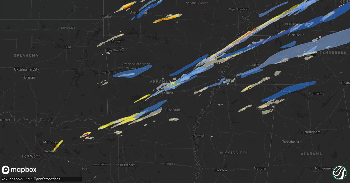
Hail Map in Arkansas on December 10, 2021
Get this storm
December 10 map
$229
one time, instant access
Download today. No call, no setup
Keep the $229
Bought the map and want the full workflow? Apply the entire $229 to a subscription within 7 days. None of it is wasted.
Every map, not just this one
This buys you this map. Subscription and you get every map we run, in the markets you choose from a few cities to whole states to nationwide. Plus real-time alerts the moment a storm fires.
Contact data
Name, contact info, occupancy, even credit band for addresses in the footprint. You go from where it hit to who to call.
Become the source they trust
Unlimited branding weather history reports on demand. You already have the documented answer ready for the property owner, and you are the one who showed up with it.
Property data and RoofTrace estimates
Pull up any address you have got, its value and the exact code rules for that jurisdiction, straight from One Click Code. Then RoofTrace estimates the squares, pitch, and roof value, priced the way you price.
Storm reports in Arkansas
Arkansas
| Date | Description |
|---|---|
| 12/10/20215:59 PM CST | Possible tornado. The woodruff county sheriff reported extensive damage on the north side of augusta. Several homes were damaged... With trees and power lines blown dow |
| 12/10/20213:35 PM CST | Corrects previous hail report from 1 ne prescott. Law enforcement reports multiple calls regarding quarter sized hail around the city of prescott. |
| 12/10/20215:42 AM CST | At 1142 PM CST, a severe thunderstorm was located over Bluff City, or 13 miles east of Prescott, moving east at 55 mph. HAZARD...60 mph wind gusts and half dollar size hail. SOURCE...Radar indicated. IMPACT...Hail damage to vehicles is expected. Expect wind damage to roofs, siding, and trees. Locations impacted include... Bearden... Sparkman... Chidester... Whelen Springs... Poison Springs State Park... White Oak Lake State Park... Amy... Eagle Mills... Manning... Ouachita... Holly Springs... Reader... Vaden... Tates Bluff... Pine Grove... Bragg City... Millville... |
| 12/10/20215:19 AM CST | At 1118 PM CST, severe thunderstorms were located along a line extending from near Warbritton to near Lamont, moving northeast at 45 mph. HAZARD...60 mph wind gusts and quarter size hail. SOURCE...Radar indicated. IMPACT...Hail damage to vehicles is expected. Expect wind damage to roofs, siding, and trees. Locations impacted include... Pine Bluff... White Hall... Altheimer... Cottondale... Lamont... Linwood... Pine Bluff Arsenal... Madding... Warbritton... Richardson... Sulphur Springs... Wabbaseka... Sherrill... Pastoria... Cornerstone... Tamo... Moscow... Glenlake... Watson Chapel... Clear Lake...This includes Interstate 530 between mile markers 27 and 46. |
| 12/10/20214:58 AM CST | At 1058 PM CST, a severe thunderstorm was located near Mandeville, or 9 miles northeast of Texarkana, moving east at 55 mph. HAZARD...60 mph wind gusts and quarter size hail. SOURCE...Radar indicated. IMPACT...Hail damage to vehicles is expected. Expect wind damage to roofs, siding, and trees. Locations impacted include... Hope, Prescott, Emmet, Perrytown, Rosston, Fulton, Bodcaw, Bluff City, White Oak Lake State Park, Cale, McNab, Patmos, Oakhaven, Sutton, Mount Moriah, Morris, Laneburg and Reader. |
| 12/10/20214:17 AM CST | At 1017 PM CST, a severe thunderstorm was located near Parkers Corner, or 11 miles south of Hazen, moving northeast at 55 mph. HAZARD...60 mph wind gusts and quarter size hail. SOURCE...Radar indicated. IMPACT...Hail damage to vehicles is expected. Expect wind damage to roofs, siding, and trees. Locations impacted include... Stuttgart... Clarendon... De Valls Bluff... Holly Grove... Fredonia... Humnoke... Ulm... Roe... Allendale... Dobbs Landing... Peppers Landing... Brummitt... Parkers Corner... Stuttgart Municipal Airport... Allport... Aberdeen... Slovak... Tollville... Casscoe... Brasfield...This includes Interstate 40 between mile markers 205 and 213. |
| 12/10/20214:06 AM CST | At 1006 PM CST, a severe thunderstorm was located 7 miles southwest of Leola, or 17 miles south of Malvern, moving east at 60 mph. HAZARD...60 mph wind gusts and quarter size hail. SOURCE...Radar indicated. IMPACT...Hail damage to vehicles is expected. Expect wind damage to roofs, siding, and trees. Locations impacted include... Pine Bluff... Sheridan... White Hall... Redfield... Leola... Carthage... Prattsville... Cottondale... Lamont... Jenkins Ferry State Park... Pine Bluff Arsenal... Warbritton... Thiel... Hensley Island... Dogwood... Sulphur Springs... Ain... Lono... Pastoria... Tulip...This includes Interstate 530 between mile markers 20 and 46. |
| 12/10/20214:02 AM CST | At 1002 PM CST, strong to severe thunderstorms were located along a line extending from Bohannon to near Dabney to near Jerusalem, moving east at 55 mph. HAZARD...60 mph wind gusts and penny size hail. SOURCE...Radar indicated. IMPACT...Expect damage to roofs, siding, and trees. Locations impacted include... Heber Springs... Mountain View... Clinton... Fairfield Bay... Greers Ferry... Shirley... Higden... Witts Spring... Rocky Hill... Dabney... Bohannon... Jerusalem... Sugar Loaf Recreation Area... Imo... Elberta... Watts... Thola... Kay... Fairfield Bay Marina... Claude... |
| 12/10/20213:37 AM CST | At 936 PM CST, a severe thunderstorm was located over Beirne, or 12 miles northeast of Prescott, moving northeast at 50 mph. HAZARD...60 mph wind gusts and half dollar size hail. SOURCE...Radar indicated. IMPACT...Hail damage to vehicles is expected. Expect wind damage to roofs, siding, and trees. Locations impacted include... Gurdon... Sparkman... Whelen Springs... Beirne... Richwoods... Burtsell... Curtis... Pine Grove... Dalark... Griffithtown... Manning... Vaden...This includes Interstate 30 between mile markers 53 and 64. |
| 12/10/20213:27 AM CST | At 926 PM CST, severe thunderstorms were located along a line extending from near Woodland to near Knoxville to near Midway in Logan County, moving east at 55 mph. HAZARD...70 mph wind gusts and quarter size hail. SOURCE...Public. IMPACT...Hail damage to vehicles is expected. Expect considerable tree damage. Wind damage is also likely to mobile homes, roofs, and outbuildings. Locations impacted include... Russellville... Clarksville... Dardanelle... Atkins... Pottsville... Lamar... Dover... London... Knoxville... Hector... Lake Dardanelle State Park... Happy Bend... Dabney... Hattieville... Jerusalem... Midway in Logan County... Blick... Taral... Holman... Cleveland...This includes Interstate 40 between mile markers 57 and 101. |
| 12/10/20213:22 AM CST | At 922 PM CST, severe thunderstorms were located along a line extending from 6 miles north of Prescott to Perrytown, moving east at 35 mph. HAZARD...60 mph wind gusts and quarter size hail. SOURCE...Radar indicated. IMPACT...Hail damage to vehicles is expected. Expect wind damage to roofs, siding, and trees. Locations impacted include... Hope, Prescott, Emmet, Perrytown, Bluff City, White Oak Lake State Park, Laneburg, Boughton, Morris and Reader. |
| 12/10/20213:19 AM CST | At 919 PM CST, a severe thunderstorm was located near Tull, or 9 miles southeast of Benton, moving northeast at 60 mph. HAZARD...60 mph wind gusts and quarter size hail. SOURCE...Radar indicated. IMPACT...Hail damage to vehicles is expected. Expect wind damage to roofs, siding, and trees. Locations impacted include... Little Rock... North Little Rock... Shannon Hills... Wrightsville... Redfield... Traskwood... Tull... Cane Creek... Ironton... Estes... East End... Orion... Sweet Home... Scott... Baseline... Bauxite... Baucum... Belfast... Higgins... College Station...This includes the following highways... Interstate 40 near mile marker 161. Interstate 530 between mile markers 1 and 20. Interstate 440 between mile markers 3 and 9. |
| 12/10/20213:13 AM CST | At 912 PM CST, a severe thunderstorm was located over McCrory, or 9 miles east of Augusta, moving northeast at 65 mph. HAZARD...60 mph wind gusts and quarter size hail. SOURCE...Radar indicated. IMPACT...Hail damage to vehicles is expected. Expect wind damage to roofs, siding, and trees. Locations impacted include... Patterson... McCrory... McFadden... Pumpkin Bend... Morton... Penrose... Wiville... Grays... |
| 12/10/20212:53 AM CST | At 853 PM CST, severe thunderstorms were located along a line extending from near Ozark to near Branch to Huntington, moving east at 50 mph. HAZARD...60 mph wind gusts and quarter size hail. SOURCE...Radar indicated. IMPACT...Hail damage to vehicles is expected. Expect wind damage to roofs, siding, and trees. Locations impacted include... Clarksville... Booneville... Paris... Lamar... Mansfield... Magazine... Knoxville... Subiaco... Hartman... Scranton... Ratcliff... Blue Mountain... Hoyt... Midway in Logan County... Holman... Woodland... Hinkle... Mount Magazine... Echo... Spadra...This includes Interstate 40 between mile markers 44 and 67. |
| 12/10/20212:45 AM CST | At 845 PM CST, a severe thunderstorm was located near Blevins, or 11 miles southeast of Murfreesboro, moving northeast at 55 mph. HAZARD...Ping pong ball size hail and 60 mph wind gusts. SOURCE...Radar indicated. IMPACT...People and animals outdoors will be injured. Expect hail damage to roofs, siding, windows, and vehicles. Expect wind damage to roofs, siding, and trees. Locations impacted include... Arkadelphia... Caddo Valley... Okolona... Gum Springs in Clark County... Richwoods... Halfway... Crater Of Diamonds State Park... DeGray Lake State Park... Delight... Antoine... Billstown... Burtsell... Lower Lake Recreation Area... Curtis... Hollywood... Pisgah... Griffithtown... Roy...This includes Interstate 30 between mile markers 54 and 80. |
| 12/10/20212:43 AM CST | At 842 PM CST, a severe thunderstorm was located over Caddo Valley, or near Arkadelphia, moving northeast at 50 mph. HAZARD...60 mph wind gusts and half dollar size hail. SOURCE...Radar indicated. IMPACT...Hail damage to vehicles is expected. Expect wind damage to roofs, siding, and trees. Locations impacted include... Benton... Bryant... Arkadelphia... Malvern... Sheridan... Haskell... Rockport... Caddo Valley... Traskwood... Tull... Prattsville... Poyen... Perla... Gum Springs in Clark County... Cane Creek... Jenkins Ferry State Park... Richwoods... Thiel... DeGray Lake State Park... Dogwood...This includes Interstate 30 between mile markers 71 and 105. |
| 12/10/20212:39 AM CST | At 839 PM CST, a severe thunderstorm was located over Tupelo, or 9 miles northeast of Augusta, moving northeast at 60 mph. HAZARD...60 mph wind gusts and quarter size hail. SOURCE...Radar indicated. IMPACT...Hail damage to vehicles is expected. Expect wind damage to roofs, siding, and trees. Locations impacted include... Tupelo... Algoa... McFadden... Beedeville... Weldon... Balch... Blackville... Fitzhugh... |
| 12/10/20212:29 AM CST | At 828 PM CST, severe thunderstorms were located along a line extending from West Point to near Parnell to Southwest Little Rock, moving northeast at 45 mph. HAZARD...70 mph wind gusts and quarter size hail. SOURCE...Radar indicated. IMPACT...Hail damage to vehicles is expected. Expect considerable tree damage. Wind damage is also likely to mobile homes, roofs, and outbuildings. Locations impacted include... Cabot... Searcy... Augusta... Beebe... Ward... Bald Knob... Austin in Lonoke County... Judsonia... Kensett... Higginson... Patterson... West Point... Old Austin... McCrory... Parnell... Hurricane Lake WMA... Sylvania... Thurman... Pryor... McRae...This includes US Highway 67 between mile markers 16 and 48, and nearmile marker 56. |
| 12/10/20212:28 AM CST | At 828 PM CST, a severe thunderstorm was located over Tollette, or near Mineral Springs, moving northeast at 55 mph. HAZARD...60 mph wind gusts and quarter size hail. SOURCE...Radar indicated. IMPACT...Hail damage to vehicles is expected. Expect wind damage to roofs, siding, and trees. Locations impacted include... Blevins, Tollette, Washington, McCaskill and Ozan. |
| 12/10/20212:14 AM CST | At 813 PM CST, severe thunderstorms were located along a line extending from near Higginson to near Thurman to Parnell to Gravel Ridge, moving northeast at 60 mph. HAZARD...60 mph wind gusts and quarter size hail. SOURCE...Radar indicated. IMPACT...Hail damage to vehicles is expected. Expect wind damage to roofs, siding, and trees. Locations impacted include... North Little Rock... Sherwood... Jacksonville... Cabot... Searcy... Augusta... Little Rock AFB... North Little Rock Airport... Beebe... Ward... Bald Knob... Austin in Lonoke County... Judsonia... Kensett... Higginson... Patterson... West Point... Old Austin... McCrory... Parnell...This includes the following highways... Interstate 40 between mile markers 148 and 149. Interstate 430 near mile marker 12. Interstate 440 near mile marker 14. US Highway 67 between mile markers 4 and 46. |
| 12/10/20212:00 AM CST | At 759 PM CST, a severe thunderstorm was located near Richmond, or 7 miles southeast of Foreman, moving northeast at 50 mph. HAZARD...60 mph wind gusts and quarter size hail. SOURCE...Radar indicated. IMPACT...Hail damage to vehicles is expected. Expect wind damage to roofs, siding, and trees. Locations impacted include... Ashdown, Mineral Springs, Wilton, Tollette, Ben Lomond, Saratoga, Richmond, Bright Star, Wallace, Millwood, Arden and Browntown. |
| 12/10/20211:49 AM CST | At 749 PM CST, a severe thunderstorm was located over Ben Lomond, or 10 miles west of Mineral Springs, moving northeast at 60 mph. HAZARD...60 mph wind gusts and quarter size hail. SOURCE...Radar indicated. IMPACT...Hail damage to vehicles is expected. Expect wind damage to roofs, siding, and trees. Locations impacted include... Arkadelphia... Murfreesboro... Glenwood... Amity... Caddo Valley... Okolona... Daisy... Gum Springs in Clark County... Halfway... Daisy State Park... Crater Of Diamonds State Park... Narrows Dam... Richwoods... Lofton... DeGray Lake State Park... Donaldson... Delight... Friendship... Bismarck... Antoine...This includes Interstate 30 between mile markers 61 and 87. |
| 12/10/20211:44 AM CST | At 744 PM CST, a severe thunderstorm was located over West Little Rock, moving east at 60 mph. HAZARD...60 mph wind gusts and quarter size hail. SOURCE...Radar indicated. IMPACT...Hail damage to vehicles is expected. Expect wind damage to roofs, siding, and trees. Locations impacted include... Little Rock... North Little Rock... Sherwood... Jacksonville... West Little Rock... Maumelle... Downtown Little Rock... Lonoke... Hazen... North Little Rock Airport... Southwest Little Rock... Carlisle... Argenta... Barrettsville... Gravel Ridge... Meto... McCreanor... Protho Junction... Lakewood... Camp Robinson...This includes the following highways... Interstate 30 between mile markers 132 and 133, and between milemarkers 135 and 142. Interstate 40 between mile markers 146 and 194. Interstate 430 between mile markers 1 and 12. Interstate 530 near mile marker 1. Interstate 630 between mile markers 1 and 7. Interstate 440 between mile markers 1 and 14. US Highway 67 between mile markers 1 and 11. |
| 12/10/20211:30 AM CST | At 729 PM CST, a severe thunderstorm was located near Ben Lomond, or 11 miles north of Ashdown, moving northeast at 50 mph. HAZARD...60 mph wind gusts and quarter size hail. SOURCE...Radar indicated. IMPACT...Hail damage to vehicles is expected. Expect wind damage to roofs, siding, and trees. Locations impacted include... Ashdown, Nashville, Mineral Springs, Dierks, Horatio, Lockesburg, Wilton, Blevins, Tollette, Winthrop, Ben Lomond, Corinth, Saratoga, Center Point, Oak Grove, McCaskill, Ozan, Silver Ridge, Central and Muddy Fork. |
| 12/10/20211:29 AM CST | At 729 PM CST, a severe thunderstorm was located over Hot Springs Village, moving northeast at 65 mph. HAZARD...60 mph wind gusts and quarter size hail. SOURCE...Radar indicated. IMPACT...Hail damage to vehicles is expected. Expect wind damage to roofs, siding, and trees. Locations impacted include... Benton... Bryant... Hot Springs Village... Houston... Wye Mountain... Salem in Saline County... Williams Junction... Otter Creek... Alexander... Avilla... Antioch in Perry County... Wye... Mountain Valley... Oak Grove in Perry County... Congo... Paron... Grape... Thornburg... Crows... Bland...This includes Interstate 30 between mile markers 126 and 127. |
| 12/10/20211:20 AM CST | Several large limbs were blown down at cane creek state park near star city. |
| 12/10/20211:06 AM CST | At 705 PM CST, a severe thunderstorm was located over Meyers, or 15 miles west of Hot Springs, moving northeast at 60 mph. HAZARD...60 mph wind gusts and quarter size hail. SOURCE...Radar indicated. IMPACT...Hail damage to vehicles is expected. Expect wind damage to roofs, siding, and trees. Locations impacted include... Hot Springs... Hot Springs Village... Mountain Pine... Hot Springs Memorial Field... Meyers... Jessieville... Lake Ouachita State Park... Rockwell... Hot Springs National Park... Oaklawn Racetrack... Sunshine... Mountain Valley... Royal... Gulpha Gorge... Hempwallace... Crystal Springs... Pearcy... |
| 12/10/202112:53 AM CST | At 653 PM CST, severe thunderstorms were located along a line extending from near Rose Bud to near Woolly Hollow State Park to near Enola, moving northeast at 55 mph. HAZARD...60 mph wind gusts and penny size hail. SOURCE...Radar indicated. IMPACT...Expect damage to roofs, siding, and trees. Locations impacted include... Heber Springs... Greenbrier... Quitman... Pangburn... Rose Bud... Enola... Mount Vernon... Crosby... Gravel Hill... Steprock... Springhill... Woolly Hollow State Park... Holland... Letona... Albion... Barney... Hickory Flat... Wilburn... Dewey... Sidon... |
| 12/10/202112:45 AM CST | At 645 PM CST, severe thunderstorms were located along a line extending from near Little Italy to 6 miles west of Pinnacle Mountain State Park to 9 miles west of Chenal Valley, moving northeast at 55 mph. HAZARD...60 mph wind gusts and penny size hail. SOURCE...Radar indicated. IMPACT...Expect damage to roofs, siding, and trees. Locations impacted include... Little Rock... North Little Rock... Conway... Sherwood... Jacksonville... Cabot... West Little Rock... Maumelle... North Little Rock Airport... Little Rock AFB... Vilonia... Mayflower... Austin in Lonoke County... Enola... Mount Vernon... Little Italy... Gravel Ridge... Olmstead... Roland in Pulaski County... Toad Suck...This includes the following highways... Interstate 40 between mile markers 121 and 154, and mile marker 156and near mile marker 158. Interstate 430 between mile markers 9 and 12. Interstate 440 between mile markers 11 and 14. US Highway 67 between mile markers 1 and 22. |
| 12/10/202112:37 AM CST | Tree reported down in brister ar. |
| 12/09/202111:48 PM CST | Trees were blown down. |
| 12/09/202111:38 PM CST | Small trees down along hwy 278 toward the ouachita county border. |
| 12/09/202111:23 PM CST | Thunderstorm winds damaged the side of a building at 4th avenue and state street. |
| 12/09/202110:13 PM CST | A tree was blown down. |
| 12/09/20219:47 PM CST | Portions of the roof of a church were blown off just off of vaden road near curtis. |
| 12/09/20219:40 PM CST | Trees were blown down northwest of gurdon. |
| 12/09/20219:35 PM CST | Corrects previous hail report correction from 1 ne prescott. Law enforcement reports multiple calls regarding quarter sized hail around the city of prescott. |
| 12/09/20219:15 PM CST | Multiple buildings damaged in trumann. |
| 12/09/20219:12 PM CST | A tree was blown down. |
| 12/09/20219:12 PM CST | A tree was blown down on highway 270 at poyen. |
| 12/09/20219:10 PM CST | Storm spotter estimated 60 mph winds and noted power outages in the city. |
| 12/09/20219:05 PM CST | A local report indicates 60 MPH wind near CAULKSVILLE |
| 12/09/20219:03 PM CST | Fire chief reports wind gusts in excess of 58mph. |
| 12/09/20218:48 PM CST | A local report indicates 1.00 inch wind near ARKADELPHIA |
| 12/09/20218:45 PM CST | Public report of slightly larger than quarter size hail from a convenience store in blevins. |
| 12/09/20218:40 PM CST | Numerous limbs down in the bono area. Utility poles snapped 6 miles southwest of town. Possible tornado. |
| 12/09/20218:35 PM CST | Law enforcement reports multiple calls regarding quarter sized hail around the city of prescott. |
| 12/09/20218:32 PM CST | Law enforcement reporting trees down just outside the prescott city limits along highway 19 north. |
| 12/09/20218:31 PM CST | Possible tornado. Several residences on highway 37 were damaged. Numerous trees were down. Time based on radar data. |
| 12/09/20218:30 PM CST | A local report indicates 1.00 inch wind near 9 SE CABOT |
| 12/09/20218:30 PM CST | This brief tornado started north of the intersection of county road 169 and hwy 37... Moving northeast along the west side of hwy 37 for about a half mile before liftin |
| 12/09/20218:30 PM CST | A local report indicates 1.00 inch wind near CABOT |
| 12/09/20218:30 PM CST | Brief tornado touchdown near cash. |
| 12/09/20218:24 PM CST | Little rock afb measured 64 mph wind gust. |
| 12/09/20218:21 PM CST | Possible tornado. Numerous power lines were blown down near highway 17 and 33 close to the woodruff county line. Time based on radar data. |
| 12/09/20218:20 PM CST | Trees and power lines were blown down. |
| 12/09/20218:13 PM CST | *** 3 inj *** this tornado developed just north of augusta...west of arkansas hwy 33...moving northeast...severely damaging homes and uprooting orsnapping trees in the |
| 12/09/20218:13 PM CST | Possible tornado. The woodruff county sheriff reported extensive damage on the north side of augusta. Several homes were damaged... With trees and power lines blown dow |
| 12/09/20218:10 PM CST | A local report indicates 1.25 inch wind near WARD |
| 12/09/20218:06 PM CST | Damage to some roofs at white river apartments in diaz. Also... The roof was blown off of a building at george kell park... And power lines were blown down. |
| 12/09/20218:06 PM CST | This tornado started just west of the white river apartments...causing roof damage to some of those apartment buildings. Damage was also noted to buildings at the georg |
| 12/09/20218:06 PM CST | Damage to some roofs at white river apartments in diaz. |
| 12/09/20218:05 PM CST | Trees reported down between foreman and ashdown along highway 32. |
| 12/09/20218:00 PM CST | A local report indicates 1.00 inch wind near 1 NE GIBSON |
| 12/09/20217:32 PM CST | Tornado reported by law enforcement. |
| 12/09/20217:25 PM CST | A local report indicates 1.00 inch wind near MOUNTAIN PINE |
| 12/09/20217:24 PM CST | Tornado reported by law enforcement. |
| 12/09/20217:20 PM CST | Quarter size and slightly larger reported near and south of winthrop. |
| 12/09/20217:12 PM CST | Quarter size hail reported just east of the ok line and west of foreman. |
| 12/09/20217:08 PM CST | Tornado reported by law enforcement. |
| 12/09/20216:20 PM CST | Possible tornado. Several residences on highway 37 were damaged. Numerous trees were down. Time based on radar data. |
| 12/09/20216:08 PM CST | Possible tornado. Numerous power lines were blown down near highway 17 and 33 close to the woodruff county line. Time based on radar data. |
All States Impacted by Hail Map on December 10, 2021
Cities Impacted by Hail Map on December 10, 2021
- Texarkana, TX
- Griffithville, AR
- Searcy, AR
- Urbana, MO
- Tunas, MO
- Macks Creek, MO
- Avery, TX
- Clarksville, TX
- De Kalb, TX
- Foreman, AR
- Haworth, OK
- Willow Springs, MO
- Cabool, MO
- Memphis, TN
- Branch, AR
- Bogata, TX
- Columbia, MO
- Hartsburg, MO
- Ashland, MO
- Prairie Grove, AR
- Summers, AR
- Lincoln, AR
- Talco, TX
- Tiptonville, TN
- Meta, MO
- Linn Creek, MO
- Brumley, MO
- Camdenton, MO
- Kaiser, MO
- Henley, MO
- Westphalia, MO
- Ulman, MO
- Montreal, MO
- Jefferson City, MO
- Eldon, MO
- Tuscumbia, MO
- Iberia, MO
- Saint Elizabeth, MO
- Eugene, MO
- Saint Thomas, MO
- Nashville, AR
- Ozan, AR
- McCaskill, AR
- Murfreesboro, AR
- Ashdown, AR
- Arkadelphia, AR
- Columbus, AR
- Mineral Springs, AR
- Prescott, AR
- Blevins, AR
- Antoine, AR
- Saratoga, AR
- Lockesburg, AR
- Okolona, AR
- Delight, AR
- Shepherdsville, KY
- Lebanon Junction, KY
- West Point, KY
- Seligman, MO
- Mountain Pine, AR
- Hot Springs National Park, AR
- Hot Springs Village, AR
- Manila, AR
- Finley, TN
- Island, KY
- Luxora, AR
- Brookland, AR
- Leachville, AR
- Union City, TN
- Princeton, KY
- Eddyville, KY
- Livermore, KY
- Portageville, MO
- Blytheville, AR
- Caraway, AR
- Ridgely, TN
- Troy, TN
- Harrisburg, AR
- Bremen, KY
- Dyersburg, TN
- Mortons Gap, KY
- Etowah, AR
- Osceola, AR
- Hornersville, MO
- Whitesville, KY
- Hickman, KY
- Lake City, AR
- Beedeville, AR
- Earlington, KY
- Hartford, KY
- Benton, KY
- Hornbeak, TN
- Keiser, AR
- Gobler, MO
- Cherry Valley, AR
- Hayti, MO
- Fancy Farm, KY
- Halls, TN
- Fulton, KY
- Augusta, AR
- Centertown, KY
- Kennett, MO
- Cash, AR
- Fisher, AR
- Wingo, KY
- Gilbertsville, KY
- Weiner, AR
- Calvert City, KY
- Trumann, AR
- Black Oak, AR
- Dawson Springs, KY
- Hickory, KY
- Jonesboro, AR
- Kuttawa, KY
- Monette, AR
- Hickory Ridge, AR
- Madisonville, KY
- Steele, MO
- White Plains, KY
- Symsonia, KY
- Bragg City, MO
- Caruthersville, MO
- Mayfield, KY
- Sacramento, KY
- Grand Rivers, KY
- McCrory, AR
- Bay, AR
- Newport, AR
- Arbyrd, MO
- Lepanto, AR
- Amagon, AR
- Clinton, KY
- Utica, KY
- Pea Ridge, AR
- Henderson, TX
- Jacksonville, AR
- Little Rock Air Force Base, AR
- Deport, TX
- Tupelo, MS
- Mooreville, MS
- Saltillo, MS
- Dover, TN
- Cadiz, KY
- Bumpus Mills, TN
- Cabot, AR
- Sherwood, AR
- Ward, AR
- Lonoke, AR
- Beebe, AR
- McRae, AR
- Austin, AR
- Long Lane, MO
- Moro, AR
- Forrest City, AR
- Brinkley, AR
- Haynes, AR
- Clarendon, AR
- Marianna, AR
- Gallatin, TN
- Leslie, MO
- Farmersville, TX
- Nevada, TX
- Greenville, IL
- Smithboro, IL
- Huntsville, AR
- Red Bay, AL
- Newbern, TN
- Dyer, TN
- Dennis, MS
- Marietta, MS
- Mantachie, MS
- Belden, MS
- New Site, MS
- Guntown, MS
- Belmont, MS
- Baldwyn, MS
- Vina, AL
- Fulton, MS
- Russellville, AL
- Golden, MS
- Shelbyville, KY
- Bagdad, KY
- Waddy, KY
- Frankfort, KY
- Gentry, AR
- Twin Oaks, OK
- Colcord, OK
- Bella Vista, AR
- Oaks, OK
- Kansas, OK
- Gravette, AR
- Decatur, AR
- Bentonville, AR
- Centerton, AR
- Hiwasse, AR
- Garfield, AR
- Bath Springs, TN
- Waynesboro, TN
- Savannah, TN
- Olivehill, TN
- Clifton, TN
- Gleason, TN
- Puryear, TN
- Dresden, TN
- Paris, TN
- Cottage Grove, TN
- Mountain Grove, MO
- Lamar, MS
- Michigan City, MS
- Ashland, MS
- Lebanon, MO
- Lancaster, KY
- Crab Orchard, KY
- Stanford, KY
- Trenton, KY
- Fort Campbell, KY
- Oak Grove, KY
- Pembroke, KY
- Marthasville, MO
- New Haven, MO
- Gerald, MO
- Washington, MO
- Rogersville, MO
- Marshfield, MO
- Strafford, MO
- Thompsons Station, TN
- Franklin, TN
- Brownstown, IL
- Saint Elmo, IL
- Gurdon, AR
- Kenton, TN
- Trimble, TN
- Owensville, MO
- Mountain View, MO
- Vanzant, MO
- Summersville, MO
- Elk Creek, MO
- Yukon, MO
- Drury, MO
- Nettleton, MS
- Eldridge, MO
- Plantersville, MS
- Amory, MS
- Park City, KY
- Smiths Grove, KY
- Cave City, KY
- Horse Cave, KY
- Watertown, TN
- Gordonsville, TN
- Lebanon, TN
- Sheridan, AR
- Washington, AR
- Leola, AR
- Carthage, AR
- Emmet, AR
- Hope, AR
- Sparkman, AR
- Elkton, KY
- Hopkinsville, KY
- Guthrie, KY
- Mammoth Cave, KY
- Brownsville, KY
- Oakland, KY
- Rocky Hill, KY
- Bowling Green, KY
- Star City, AR
- Rison, AR
- Auburn, KY
- Russellville, KY
- Olmstead, KY
- Lewisburg, KY
- Texarkana, AR
- Subiaco, AR
- Paris, AR
- New Blaine, AR
- Scranton, AR
- Falls Of Rough, KY
- Harned, KY
- Garfield, KY
- Hardinsburg, KY
- Paint Lick, KY
- Miller, MO
- Ash Grove, MO
- Everton, MO
- Caddo Mills, TX
- Guston, KY
- Holly Springs, MS
- Falkner, MS
- Walnut, MS
- Parsons, TN
- Lobelville, TN
- Centerville, TN
- Linden, TN
- Middleton, TN
- Ramer, TN
- Stantonville, TN
- Pocahontas, TN
- Tiplersville, MS
- Adamsville, TN
- Selmer, TN
- Sulphur Bluff, TX
- Lake Creek, TX
- Cooper, TX
- Effingham, IL
- Altamont, IL
- Chesterfield, MO
- Saint Louis, MO
- La Vergne, TN
- Paron, AR
- Walnut Grove, MO
- South Greenfield, MO
- Greenfield, MO
- Lockwood, MO
- Vienna, MO
- Ava, MO
- Beaufort, MO
- Royse City, TX
- Celeste, TX
- Lavon, TX
- Greenville, TX
- Rockwall, TX
- Oxford, MS
- Paris, MS
- Pontotoc, MS
- Water Valley, MS
- Thaxton, MS
- Ecru, MS
- Ballwin, MO
- Cuba, MO
- Rosebud, MO
- Pomona, MO
- El Paso, AR
- Maryland Heights, MO
- Granite City, IL
- Pacific, MO
- East Alton, IL
- Hartford, IL
- Saint Ann, MO
- South Roxana, IL
- Roxana, IL
- Wildwood, MO
- Sardis, MS
- Crenshaw, MS
- Maumelle, AR
- Little Rock, AR
- Nolensville, TN
- Brentwood, TN
- Antioch, TN
- Bonnerdale, AR
- Coffeen, IL
- Falcon, MO
- Grovespring, MO
- Custer, KY
- Ekron, KY
- Irvington, KY
- Clermont, KY
- Radcliff, KY
- Vine Grove, KY
- Rineyville, KY
- Cecilia, KY
- Fort Knox, KY
- Mount Washington, KY
- Canton, TX
- Alexander, AR
- Lyles, TN
- Bon Aqua, TN
- Sledge, MS
- Bland, MO
- Belle, MO
- Rives, TN
- Valley Park, MO
- Eureka, MO
- Union, MO
- Mount Pleasant, TX
- Tremont, MS
- Washburn, MO
- Cassville, MO
- Exeter, MO
- Higginson, AR
- Bald Knob, AR
- Charleston, AR
- Ratcliff, AR
- Inverness, MS
- Goodlettsville, TN
- Madison, TN
- Hendersonville, TN
- Cottontown, TN
- Aubrey, AR
- Cameron, OK
- Vichy, MO
- Stilwell, OK
- Westville, OK
- Aldrich, MO
- Dadeville, MO
- Golden City, MO
- Brighton, MO
- Sarcoxie, MO
- Morrisville, MO
- Reeds, MO
- La Russell, MO
- Carthage, MO
- Bolivar, MO
- Magnolia, KY
- Mount Sherman, KY
- Herndon, KY
- Elkland, MO
- Windyville, MO
- Phillipsburg, MO
- Buffalo, MO
- Nashville, TN
- Royal, AR
- Wister, OK
- Judsonia, AR
- Louisburg, MO
- Half Way, MO
- Walshville, IL
- Panama, IL
- Hillsboro, IL
- Donnellson, IL
- Sullivan, MO
- North Little Rock, AR
- Benton, AR
- Avilla, MO
- Sharon, TN
- Martin, TN
- Palmersville, TN
- Chidester, AR
- Rutherford, TN
- Cordova, TN
- Collierville, TN
- Germantown, TN
- Eads, TN
- Florissant, MO
- Frankford, MO
- Louisiana, MO
- Norwood, MO
- Greenbrier, AR
- Wilton, AR
- Donaldson, AR
- Alleene, AR
- Poteau, OK
- Howe, OK
- Olaton, KY
- New Douglas, IL
- Sorento, IL
- Fillmore, IL
- Stoutland, MO
- Richland, MO
- Dike, TX
- Hindsville, AR
- Primm Springs, TN
- Buffalo, KY
- Campbellsville, KY
- Mayflower, AR
- Garner, AR
- Conway, AR
- Roland, AR
- Lonsdale, AR
- Kensett, AR
- Vilonia, AR
- Spring Hill, TN
- Columbia, TN
- College Grove, TN
- Magazine, AR
- Rowlett, TX
- Leitchfield, KY
- Hudson, KY
- Beaver Dam, KY
- Westview, KY
- McDaniels, KY
- Nortonville, KY
- Central City, KY
- Graham, KY
- Water Valley, KY
- Dundee, KY
- Horse Branch, KY
- McHenry, KY
- Saint Charles, KY
- Fordsville, KY
- Oil Trough, AR
- Bradford, AR
- Thida, AR
- Swifton, AR
- Pleasant Plains, AR
- Mount Vernon, AR
- Letona, AR
- Tuckerman, AR
- Pangburn, AR
- Bono, AR
- Heber Springs, AR
- Romance, AR
- Rose Bud, AR
- Des Arc, AR
- Carlisle, AR
- Marked Tree, AR
- Altus, AR
- Jerusalem, AR
- Lamar, AR
- Greenwood, AR
- Knoxville, AR
- Dover, AR
- London, AR
- Ozark, AR
- Coal Hill, AR
- Lavaca, AR
- Hartman, AR
- Pelsor, AR
- Clarksville, AR
- Delaware, AR
- Fort Smith, AR
- Hector, AR
- Russellville, AR
- Malvern, AR
- Prattsville, AR
- Redfield, AR
- Hensley, AR
- Friendship, AR
- Bauxite, AR
- Poyen, AR
- Traskwood, AR
- Hughes, AR
- Heth, AR
- Marion, AR
- Proctor, AR
- West Memphis, AR
- Ada, OH
- Alger, OH
- Fredonia, KY
- Edwardsville, IL
- Reynolds Station, KY
- Crofton, KY
- Caneyville, KY
- Powderly, KY
- Greenville, KY
- Rockport, KY
- Paducah, KY
- Golconda, IL
- Smithland, KY
- Metropolis, IL
- Clay, KY
- West Paducah, KY
- Marion, KY
- Providence, KY
- Brookport, IL
- Hampton, KY
- Dixon, KY
- Burna, KY
- Salem, KY
- Louisville, KY
- Coxs Creek, KY
- Taylorsville, KY
- Fisherville, KY
- Rockfield, KY
- Nunnelly, TN
- Ashland City, TN
- Beech Bluff, TN
- New Johnsonville, TN
- Kingston Springs, TN
- Huron, TN
- Charlotte, TN
- White Bluff, TN
- Gainesboro, TN
- Alpine, TN
- Jackson, TN
- Darden, TN
- Yuma, TN
- Pegram, TN
- Hestand, KY
- Chestnut Mound, TN
- Lafayette, TN
- Sugar Tree, TN
- Holladay, TN
- Cedar Grove, TN
- Waverly, TN
- Hurricane Mills, TN
- Buffalo Valley, TN
- Henderson, TN
- Albany, KY
- Whites Creek, TN
- Pall Mall, TN
- Red Boiling Springs, TN
- Livingston, TN
- Elmwood, TN
- Tompkinsville, KY
- Toone, TN
- Oakland, TN
- Stearns, KY
- Monroe, TN
- Whiteville, TN
- Wildersville, TN
- Only, TN
- Moss, TN
- Hartsville, TN
- Baxter, TN
- Mount Juliet, TN
- Cookeville, TN
- Bethpage, TN
- Joelton, TN
- Byrdstown, TN
- Fairview, TN
- Celina, TN
- Mercer, TN
- Whitleyville, TN
- Dixon Springs, TN
- Carthage, TN
- Mason, TN
- Granville, TN
- Somerville, TN
- Dickson, TN
- Brush Creek, TN
- Medon, TN
- Burns, TN
- Westport, TN
- McEwen, TN
- Burkesville, KY
- Hermitage, TN
- Riddleton, TN
- Luray, TN
- Pinson, TN
- Bloomington Springs, TN
- Old Hickory, TN
- Camden, TN
- Rickman, TN
- Allons, TN
- Castalian Springs, TN
- Hickman, TN
- Jamestown, TN
- Pleasant Shade, TN
- Alpha, KY
- Monticello, KY
- Lexington, TN
- Hilham, TN
- Arlington, TN
- Bolivar, TN
- Cumberland Furnace, TN
- Cunningham, TN
- Vanleer, TN
- Erin, TN
- Danville, KY
- Irvine, KY
- Edmonton, KY
- Waco, KY
- Parksville, KY
- New Concord, KY
- Glasgow, KY
- Center, KY
- Canmer, KY
- Allensville, KY
- Munfordville, KY
- Hardyville, KY
- Clay City, KY
- Buchanan, TN
- Hustonville, KY
- Perryville, KY
- Greenfield, TN
- Winchester, KY
- Summersville, KY
- Greensburg, KY
- Morgantown, KY
- La Fayette, KY
- Franklin, KY
- Clarksville, TN
- Alvaton, KY
- Knob Lick, KY
- Henry, TN
- Richmond, KY
- Bonnieville, KY
- Bradfordsville, KY
- Dell, AR
- Junction City, KY
- Big Rock, TN
- Lebanon, KY
- Woodburn, KY
- Adairville, KY
- Gravel Switch, KY
- Gruetli Laager, TN
- Palmer, TN
- Tracy City, TN
- Coalmont, TN
- Prospect, TN
- Ardmore, TN
- Athens, AL
- Town Creek, AL
- Minor Hill, TN
- Tishomingo, MS
- Sheffield, AL
- Five Points, TN
- Taft, TN
- Dellrose, TN
- Ardmore, AL
- Cherokee, AL
- Muscle Shoals, AL
- Iuka, MS
- Tuscumbia, AL
- Booneville, MS
- Lexington, AL
- Lester, AL
- Florence, AL
- Elkmont, AL
- Killen, AL
- Leighton, AL
- Anderson, AL
- Fayetteville, TN
- Rogersville, AL
- Winthrop, AR
- Clever, MO
- Billings, MO
- Marionville, MO
- Newburg, MO
- Fort Leonard Wood, MO
- Devils Elbow, MO
- Rolla, MO
- Saint Robert, MO
- Laquey, MO
- Duke, MO
- Fair Grove, MO
- Springfield, MO
- Conway, MO
- Waynesville, MO
- Dixon, MO
- Niangua, MO
- Edgar Springs, MO
- Nixa, MO
- Ozark, MO
- Martinsville, IL
- Lebanon, IN
- Alhambra, IL
- Venice, IL
- Veedersburg, IN
- Kansas, IL
- Ramsey, IL
- Staunton, IN
- Cory, IN
- West Terre Haute, IN
- Montezuma, IN
- Roachdale, IN
- Greenup, IL
- Shelbyville, IL
- Crawfordsville, IN
- Bridgeton, IN
- Labadie, MO
- Fillmore, IN
- Madison, IL
- Tipton, IN
- Greentown, IN
- Mattoon, IL
- Windsor, IL
- Russellville, IN
- Strasburg, IL
- Riley, IN
- Danville, IN
- Metcalf, IL
- Westfield, IL
- Cowden, IL
- Terre Haute, IN
- Atlanta, IN
- Fairmount, IN
- Dennison, IL
- Montpelier, IN
- Summitville, IN
- Gas City, IN
- Marion, IN
- Greencastle, IN
- Kingman, IN
- Alamo, IN
- Brocton, IL
- Toledo, IL
- Frankfort, IN
- Marshall, IL
- North Salem, IN
- Goldsmith, IN
- Colfax, IN
- Gray Summit, MO
- Hindsboro, IL
- Swayzee, IN
- Oconee, IL
- Darlington, IN
- Vermilion, IL
- Neoga, IL
- Trilla, IL
- Teutopolis, IL
- Jonesboro, IN
- Chrisman, IL
- New Goshen, IN
- Waveland, IN
- Newman, IL
- Alexandria, IN
- Oakland, IL
- Brazil, IN
- Villa Ridge, MO
- Beecher City, IL
- Bingham, IL
- Universal, IN
- Clinton, IN
- Pana, IL
- Cicero, IN
- Coatesville, IN
- Saint James, MO
- Kempton, IN
- Whitestown, IN
- Hamel, IL
- Mecca, IN
- Arcola, IL
- Knightsville, IN
- Covington, IN
- Bloomingdale, IN
- Warren, IN
- Upland, IN
- Tower Hill, IL
- Waynetown, IN
- Harmony, IN
- Lerna, IL
- Humboldt, IL
- Hartford City, IN
- Ridge Farm, IL
- Worden, IL
- Windfall, IN
- Paris, IL
- Mode, IL
- Perrysville, IN
- Dana, IN
- Arcadia, IN
- Carbon, IN
- Shumway, IL
- Charleston, IL
- Stewardson, IL
- Rosedale, IN
- Crocker, MO
- Redmon, IL
- Rockville, IN
- Montrose, IL
- Cayuga, IN
- Van Buren, IN
- Kirklin, IN
- Jamestown, IN
- Casey, IL
- Marshall, IN
- Bainbridge, IN
- Sigel, IL
- Elwood, IN
- Lakewood, IL
- Gays, IL
- Hume, IL
- Glen Carbon, IL
- Herrick, IL
- Reelsville, IN
- Hillsboro, IN
- Hillsdale, IN
- Sheridan, IN
- Ladoga, IN
- Ashmore, IL
- Thorntown, IN
- Kingdom City, MO
- Laddonia, MO
- Delavan, IL
- Mexico, MO
- Rockport, IL
- Fulton, MO
- Griggsville, IL
- Pleasant Hill, IL
- Mount Sterling, IL
- Chandlerville, IL
- Mason City, IL
- New Holland, IL
- Meredosia, IL
- Versailles, IL
- Bluffs, IL
- Arenzville, IL
- Ashland, IL
- San Jose, IL
- Auxvasse, MO
- Wellsville, MO
- Oakford, IL
- Middletown, MO
- Virginia, IL
- New Bloomfield, MO
- Easton, IL
- Perry, IL
- Armington, IL
- Minier, IL
- Beardstown, IL
- Martinsburg, MO
- Hopedale, IL
- Bowling Green, MO
- New Salem, IL
- Pittsfield, IL
- New Canton, IL
- Concord, IL
- Petersburg, IL
- Barry, IL
- Benton City, MO
- Chambersburg, IL
- Greenview, IL
- Emden, IL
- Baylis, IL
- Chapin, IL
- Vandalia, MO
- Curryville, MO
- Hartsburg, IL
- Freeburg, MO
- Lake Saint Louis, MO
- Wentzville, MO
- Linn, MO
- Brighton, IL
- Wright City, MO
- Hermann, MO
- Loose Creek, MO
- Morrison, MO
- Troy, MO
- Brussels, IL
- Rhineland, MO
- Jonesburg, MO
- Shipman, IL
- Truesdale, MO
- Moscow Mills, MO
- Chamois, MO
- Batchtown, IL
- Jerseyville, IL
- Golden Eagle, IL
- Bonnots Mill, MO
- Foristell, MO
- Dow, IL
- Foley, MO
- Portage Des Sioux, MO
- Elsah, IL
- Fieldon, IL
- Warrenton, MO
- Carlinville, IL
- Godfrey, IL
- Winfield, MO
- Piasa, IL
- Old Monroe, MO
- Berger, MO
- Medora, IL
- Fidelity, IL
- Grafton, IL
- O'Fallon, MO
- Moweaqua, IL
- Sawyerville, IL
- Bringhurst, IN
- Westpoint, IN
- Galveston, IN
- Bridgeton, MO
- Assumption, IL
- Collison, IL
- Monticello, IN
- Hazelwood, MO
- Dorsey, IL
- Sidney, IL
- Mount Olive, IL
- Thomasboro, IL
- Pesotum, IL
- Bethalto, IL
- Brookston, IN
- Pine Village, IN
- Royal Center, IN
- Alton, IL
- La Place, IL
- Tuscola, IL
- Rossville, IL
- Argenta, IL
- Champaign, IL
- Alvin, IL
- Fithian, IL
- Mt Zion, IL
- West Lafayette, IN
- Staunton, IL
- Benld, IL
- Irving, IL
- Flora, IN
- Augusta, MO
- Otterbein, IN
- Bismarck, IL
- Dalton City, IL
- Sadorus, IL
- Fairmount, IL
- Cerro Gordo, IL
- Attica, IN
- Saint Peters, MO
- Walton, IN
- Monticello, IL
- Camden, IN
- Burnettsville, IN
- Logansport, IN
- Ivesdale, IL
- Urbana, IL
- Rossville, IN
- Harvel, IL
- Yeoman, IN
- Ogden, IL
- Saint Joseph, IL
- Saint Charles, MO
- Tolono, IL
- Oakwood, IL
- Williamsport, IN
- West Lebanon, IN
- Danville, IL
- Henning, IL
- Penfield, IL
- Potomac, IL
- Defiance, MO
- Taylorville, IL
- Morrisonville, IL
- Butler, IL
- Savoy, IL
- Delphi, IN
- Gillespie, IL
- Battle Ground, IN
- Buck Creek, IN
- Hammond, IL
- Raymond, IL
- Wood River, IL
- Wilsonville, IL
- Nokomis, IL
- Owaneco, IL
- West Alton, MO
- Muncie, IL
- Lafayette, IN
- Decatur, IL
- Lovington, IL
- Gifford, IL
- Lucerne, IN
- Moro, IL
- Homer, IL
- Earth City, MO
- Atwood, IL
- Idaville, IN
- Litchfield, IL
- Armstrong, IL
- Macon, IL
- Cottage Hills, IL
- Witt, IL
- Chalmers, IN
- Philo, IL
- Bunker Hill, IL
- Royal, IL
- Bement, IL
- Morton, IL
- Congerville, IL
- Goodfield, IL
- Secor, IL
- Deer Creek, IL
- El Paso, IL
- Pekin, IL
- Green Valley, IL
- Eureka, IL
- Mackinaw, IL
- Tremont, IL
- Carlock, IL
- Chestnut, IL
- Latham, IL
- Kenney, IL
- Mount Pulaski, IL
- Maroa, IL
- Clinton, IL
- Knox, IN
- Hanna, IN
- Rensselaer, IN
- Demotte, IN
- Valparaiso, IN
- Union Mills, IN
- North Liberty, IN
- Kingsford Heights, IN
- La Crosse, IN
- La Porte, IN
- Hamlet, IN
- Walkerton, IN
- Kouts, IN
- Fair Oaks, IN
- Wheatfield, IN
- Wanatah, IN
- New Carlisle, IN
- Mill Creek, IN
- South Bend, IN
- Francesville, IN
- Medaryville, IN
- Brook, IN
- Winamac, IN
- Morocco, IN
- Monterey, IN
- North Judson, IN
- Lyons, IN
- Bloomfield, IN
- Newberry, IN
- Highland, IL
- Mulberry Grove, IL
- Vandalia, IL
- Jewett, IL
- Pocahontas, IL
- Watson, IL
- Cedar Lake, IN
- Crown Point, IN
- Reeds Spring, MO
- Walnut Shade, MO
- Redford, MO
- Ellington, MO


