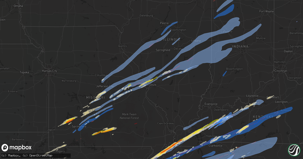
Hail Map on December 10, 2021
Get this storm
December 10 map
$229
one time, instant access
Download today. No call, no setup
Keep the $229
Bought the map and want the full workflow? Apply the entire $229 to a subscription within 7 days. None of it is wasted.
Every map, not just this one
This buys you this map. Subscription and you get every map we run, in the markets you choose from a few cities to whole states to nationwide. Plus real-time alerts the moment a storm fires.
Contact data
Name, contact info, occupancy, even credit band for addresses in the footprint. You go from where it hit to who to call.
Become the source they trust
Unlimited branding weather history reports on demand. You already have the documented answer ready for the property owner, and you are the one who showed up with it.
Property data and RoofTrace estimates
Pull up any address you have got, its value and the exact code rules for that jurisdiction, straight from One Click Code. Then RoofTrace estimates the squares, pitch, and roof value, priced the way you price.
States Impacted by Hail Map on December 10, 2021
Storm reports
Louisiana
| Date | Description |
|---|---|
| 12/10/20214:53 AM CST | At 1052 PM CST, a severe thunderstorm was located 7 miles northwest of Cedar Springs, or 10 miles southeast of Pittsburg, moving east at 45 mph. HAZARD...60 mph wind gusts. SOURCE...Radar indicated. IMPACT...Expect damage to roofs, siding, and trees. Locations impacted include... Gilmer, Vivian, Daingerfield, Jefferson, Linden, Hughes Springs, Lone Star, Ore City, Lodi, Smithland, McLeod, Berea, Harleton, Kildare, Diana, Karnack, Woodlawn, Jenkins, Cedar Springs and Gray. |
| 12/10/20211:00 AM CST | Flag pole reported down as well as 2 trees and some large limbs on and near barron road. |
| 12/10/202112:45 AM CST | Tree reported down on henry williams road. |
Illinois
| Date | Description |
|---|---|
| 12/10/20215:55 AM CST | At 1155 PM EST, severe thunderstorms were located along a line extending from 6 miles north of Otterbein to near Vermilion, moving east at 55 mph. HAZARD...60 mph wind gusts. SOURCE...Radar indicated. IMPACT...Expect damage to roofs, siding, and trees. Severe thunderstorms will be near... Rosedale and Mecca around 1210 AM EST.Other locations in the path of these severe thunderstorms includeRockville, Judson and Cecil Harden Lake.This includes the following highways... Interstate 65 between mile markers 175 and 183. Interstate 74 between mile markers 1 and 31. |
| 12/10/20215:40 AM CST | At 1140 PM CST, severe thunderstorms were located along a line extending from near Westfield to near Greenup to near Watson, moving east at 65 mph. HAZARD...60 mph wind gusts. SOURCE...Radar indicated. IMPACT...Expect damage to roofs, siding, and trees. Severe thunderstorms will be near... Toledo, Greenup and Westfield around 1145 PM CST. Casey and Kansas around 1150 PM CST. Martinsville, Montrose and Clarksville around 1155 PM CST. Paris, Jewett and Oliver around 1200 AM CST.Other locations in the path of these severe thunderstorms includeMarshall, Vermilion, Hidalgo, Hazel Dell and Dennison.This includes the following highways... Interstate 57 between mile markers 154 and 174. Interstate 70 between mile markers 79 and 154. |
| 12/10/20214:56 AM CST | At 1055 PM CST, severe thunderstorms were located along a line extending from near Tower Hill to near Wrights Corner, moving east at 70 mph. HAZARD...60 mph wind gusts. SOURCE...Radar indicated. IMPACT...Expect damage to roofs, siding, and trees. Severe thunderstorms will be near... Shelbyville around 1100 PM CST. Effingham, Windsor, Stewardson and Shumway around 1110 PM CST. Teutopolis around 1115 PM CST.Other locations in the path of these severe thunderstorms includeMattoon, Montrose, Lerna, Jewett, Charleston, Toledo, Greenup,Hidalgo, Ashmore, Rardin, Hazel Dell and Casey.This includes the following highways... Interstate 57 between mile markers 145 and 195. Interstate 70 between mile markers 79 and 126. |
| 12/10/20214:51 AM CST | At 1050 PM CST, a severe thunderstorm was located near New Memphis, moving northeast at 75 mph. HAZARD...60 mph wind gusts and penny size hail. SOURCE...Radar indicated. IMPACT...Expect damage to roofs, siding, and trees. This severe thunderstorm will be near... Okawville and Germantown around 1100 PM CST. Beckemeyer around 1105 PM CST.Other locations in the path of this severe thunderstorm include Wamacand Shattuc.This includes Interstate 64 in Illinois between exits 34 and 61. |
| 12/10/20214:18 AM CST | At 1017 PM CST, severe thunderstorms were located along a line extending from near Mount Olive to near Sorento to near Troy, moving east at 70 mph. HAZARD...60 mph wind gusts. SOURCE...Radar indicated. IMPACT...Expect damage to roofs, siding, and trees. Severe thunderstorms will be near... Litchfield, Taylor Springs, Sorento and Reno around 1025 PM CST. Hillsboro, Coffeen, Schram City and Woburn around 1030 PM CST. Witt, Pocahontas and Van Burensburg around 1035 PM CST.Other locations in the path of these severe thunderstorms includeGreenville, Nokomis, Beaver Creek, Ramsey, Tamalco, Mulberry Grove,Vandalia, Wrights Corner, Shobonier and Brownstown.This includes the following highways... Interstate 70 in Illinois between exits 30 and 76. Interstate 55 in Illinois near exit 44. Interstate 57 in Illinois near exit 135.This also includes Ramsey Lake State Park. |
| 12/10/20213:51 AM CST | At 950 PM CST, severe thunderstorms were located along a line extending from near Atwood to near Stewardson, moving northeast at 55 mph. HAZARD...60 mph wind gusts. SOURCE...Radar indicated. IMPACT...Expect damage to roofs, siding, and trees. Severe thunderstorms will be near... Atwood around 955 PM CST. Mattoon and Pesotum around 1005 PM CST. Lerna and Cooks Mill around 1010 PM CST.Other locations in the path of these severe thunderstorms includeCharleston, Humboldt, Homer, Ashmore, Rardin, Oakland, Hindsboro andNewman.This includes the following highways... Interstate 57 between mile markers 170 and 222. Interstate 70 between mile markers 121 and 126. |
| 12/10/20213:33 AM CST | At 933 PM CST, severe thunderstorms were located along a line extending from near Fisher to near Bement, moving northeast at 75 mph. HAZARD...60 mph wind gusts. SOURCE...Radar indicated. IMPACT...Expect damage to roofs, siding, and trees. Severe thunderstorms will be near... Rantoul around 940 PM CST. Bondville and Seymour around 945 PM CST. Champaign, Savoy, Tolono and Rankin around 950 PM CST.Other locations in the path of these severe thunderstorms includeUrbana, Philo, Sidney, St. Joseph, Ogden and Potomac.This includes the following highways... Interstate 57 between mile markers 222 and 257. Interstate 72 between mile markers 165 and 182. Interstate 74 between mile markers 164 and 200. |
| 12/10/20213:27 AM CST | At 926 PM CST, severe thunderstorms were located along a line extending from near Forrest to near Saybrook, moving northeast at 70 mph. HAZARD...60 mph wind gusts. SOURCE...Radar indicated. IMPACT...Expect damage to roofs, siding, and trees. Locations impacted include... Paxton, Gibson City, Gilman, Clifton, Chatsworth, Onarga, Forrest, Chebanse, Cissna Park, Piper City, Ashkum, Buckley, Crescent City, Danforth, Melvin, Loda, Roberts, Elliott, Sibley and Thawville. |
| 12/10/20213:26 AM CST | At 926 PM CST, severe thunderstorms were located along a line extending from near Miner to near Lilbourn, moving northeast at 50 mph. HAZARD...60 mph wind gusts. SOURCE...Radar indicated. IMPACT...Expect damage to roofs, siding, and trees. Severe thunderstorms will be near... Miner and Bertrand around 930 PM CST. Charleston around 935 PM CST. East Prairie around 945 PM CST.Other locations in the path of these severe thunderstorms includeTowosahgy State Historic Site, Anniston and Wyatt.This includes the following highways... Interstate 57 in Missouri between Mile Markers 1 and 17. Interstate 55 between Mile Markers 45 and 71. |
| 12/10/20213:26 AM CST | At 926 PM CST, a severe thunderstorm was located over Coal City, moving northeast at 60 mph. HAZARD...60 mph wind gusts. SOURCE...Radar indicated. IMPACT...Expect damage to roofs, siding, and trees. Locations impacted include... Joliet, Orland Park, Tinley Park, Lockport, New Lenox, Homer Glen, Park Forest, Mokena, Frankfort, Channahon, Minooka, Braidwood, Wilmington, Coal City, Frankfort Square, University Park, Manhattan, Ingalls Park, Diamond and Elwood.Including the following interstates... I-55 between mile markers 235 and 249. I-57 between mile markers 337 and 338. I-80 between mile markers 128 and 149. I-355 between mile markers 1 and 4.This includes... University of St. Francis, Channahon State Park,Chicagoland Speedway...Route 66 Raceway, and Joliet SlammersBaseball. |
| 12/10/20213:09 AM CST | At 909 PM CST, severe thunderstorms were located along a line extending from near Blue Mound to 6 miles northwest of Nokomis, moving east at 50 mph. HAZARD...60 mph wind gusts. SOURCE...Radar indicated. IMPACT...Expect damage to roofs, siding, and trees. Severe thunderstorms will be near... Blue Mound around 915 PM CST. Macon around 920 PM CST. Pana around 925 PM CST.Other locations in the path of these severe thunderstorms includeMount Zion, Long Creek, Assumption, Tower Hill, Dalton City,Westervelt, Findlay, Hammond, Bethany, Sullivan, Lovington andAllenville.This includes Interstate 57 between mile markers 169 and 170. |
| 12/10/20212:58 AM CST | At 858 PM CST, severe thunderstorms were located along a line extending from near Heyworth to near Stonington, moving northeast at 50 mph. HAZARD...60 mph wind gusts. SOURCE...Radar indicated. IMPACT...Expect damage to roofs, siding, and trees. Severe thunderstorms will be near... Heyworth and Wapella around 905 PM CST. Le Roy and Harristown around 915 PM CST.Other locations in the path of these severe thunderstorms includeDecatur, Mount Zion, Long Creek, Oreana, Saybrook and Cerro Gordo.This includes the following highways... Interstate 72 between mile markers 124 and 164. Interstate 74 between mile markers 146 and 164. |
| 12/10/20212:32 AM CST | At 831 PM CST, a severe thunderstorm was located over Cornland, or 14 miles south of Lincoln, moving northeast at 65 mph. HAZARD...60 mph wind gusts. SOURCE...Radar indicated. IMPACT...Expect damage to roofs, siding, and trees. This severe thunderstorm will be near... Mount Pulaski around 840 PM CST. Latham and Chestnut around 845 PM CST. Beason around 850 PM CST.This includes the following highways... Interstate 55 between mile markers 116 and 117. Interstate 72 between mile markers 105 and 114. |
| 12/10/20212:20 AM CST | At 820 PM CST, a severe thunderstorm was located over Auburn, or 7 miles north of Virden, moving northeast at 60 mph. HAZARD...60 mph wind gusts. SOURCE...Radar indicated. IMPACT...Expect damage to roofs, siding, and trees. This severe thunderstorm will be near... Pawnee around 825 PM CST. Springfield around 830 PM CST. Rochester around 835 PM CST. Edinburg around 840 PM CST.Other locations in the path of this severe thunderstorm includeMechanicsburg, Mount Auburn and Illiopolis.This includes the following highways... Interstate 55 between mile markers 77 and 94. Interstate 72 between mile markers 98 and 100, and between milemarkers 114 and 124. |
| 12/09/202111:48 PM CST | Measured by carbondale airport asos. |
| 12/09/202111:35 PM CST | Awos station kprg edgar county ap. |
| 12/09/202111:31 PM CST | The dome was blown off the salt storage building at the tazewell county highway department. |
| 12/09/202111:31 PM CST | Report of trees down and a damaged machine shed. |
| 12/09/202111:06 PM CST | Power lines were blown down. |
| 12/09/202110:53 PM CST | Asos station klwv lawrenceville ap. |
| 12/09/202110:51 PM CST | Asos station kmto coles county mem ap. |
| 12/09/202110:38 PM CST | Report of a tree down. |
| 12/09/202110:38 PM CST | Report of powerlines down. |
| 12/09/202110:35 PM CST | Reports of dense styrofoam material scattered across taylor springs as well asrom radar. |
| 12/09/202110:35 PM CST | Trees and powerlines down. |
| 12/09/202110:35 PM CST | Reports of dense styrofoam material scattered across taylor springs as well as neighboring communities. |
| 12/09/202110:22 PM CST | Corrects time on previous tstm wnd gst report from lawrenceville airport. Asos station klwv lawrenceville ap. |
| 12/09/202110:16 PM CST | A local report indicates 65 MPH wind near SIDNEY |
| 12/09/202110:10 PM CST | Machine shed destroyed. |
| 12/09/202110:04 PM CST | A house was severely damaged with people trapped inside. |
| 12/09/202110:02 PM CST | A machine shed was destroyed and numerous power lines were blown down near 800 north and 200 east. |
| 12/09/202110:00 PM CST | A semi was blown over near the rural king distribution center. |
| 12/09/20219:53 PM CST | Fs plant was destroyed along rt 16 west of gays. |
| 12/09/20219:52 PM CST | Trees down and power poles bent along rt 16 just northeast of windsor. Silos blown down and houses damaged between windsor and gays. |
| 12/09/20219:50 PM CST | Trees were blown down and power poles were bent along rt 16 just northeast of windsor. |
| 12/09/20219:48 PM CST | Couple large trees downed on the outskirts of town. |
| 12/09/20219:44 PM CST | Several large evergreen trees damaged. |
| 12/09/20219:44 PM CST | Measured by personal weather station. Anemometer was mounted 10 feet above ground. |
| 12/09/20219:34 PM CST | Two semis blown on to their sides on i-57 near mile marker 302. Time estimated based on radar. |
| 12/09/20219:30 PM CST | Roof partially blown off a residential building and a couple trees downed. |
| 12/09/20219:27 PM CST | Large tree downed. Time estimated. |
| 12/09/20219:19 PM CST | Numerous large tree limbs as well as a couple of trees snapped off on the entrance way into ramsey lake state park. |
| 12/09/20219:15 PM CST | Awos station kpnt pontiac airport. |
| 12/09/20219:08 PM CST | Montgomery county dispatch reported tree limbs impeding traffic along illinois route 185 near rocky ford road and along happy lane and merry lane. Time estimated from r |
| 12/09/20219:06 PM CST | Bond county dispatch reported tree on hwy 185 just south of coffeen. Time estimated from radar. |
| 12/09/20219:05 PM CST | Tds evident from klsx. |
| 12/09/20219:05 PM CST | Bond county dispatch reported a tree down on mount moriah avenue just west of red ball trail. Time estimated from radar. |
| 12/09/20218:52 PM CST | Asos station kspi springfield capital ap. |
| 12/09/20218:50 PM CST | Power poles were snapped along 600 street just west of 2400 avenue. Neighboring communities. |
| 12/09/20218:50 PM CST | Power poles were snapped along 600 street just west of 2400 avenue. |
| 12/09/20218:40 PM CST | Macoupin county dispatch reported power lines down on school house road east of dorchester road west of staunton. Time estimated from radar. |
| 12/09/20218:38 PM CST | Power outages have occurred. |
| 12/09/20218:36 PM CST | Several power poles blown down in the same direction. Time estimated by radar. |
| 12/09/20218:33 PM CST | Corrects time on previous tstm wnd gst report from 1 nnw capital airport. Asos station kspi springfield capital ap. |
| 12/09/20218:33 PM CST | Macoupin county dispatch reported tree down on hwy 159. Time estimated from radar. |
| 12/09/20218:29 PM CST | Tractor-trailer overturned on i-270 wb near milepost 7 with cables across the roadway. |
| 12/09/20218:27 PM CST | Emergency management reported a partial roof collapse at an amazon warehouse southwest of edwardsville. Multiple people are trapped at this time. |
| 12/09/20218:25 PM CST | Measured at the tazewell county eoc. |
| 12/09/20218:25 PM CST | Measured gust at the tazewell county eoc. |
| 12/09/20218:25 PM CST | Power lines were blown down near rt 4 and cottonwood drive south of the walgreens. |
| 12/09/20218:20 PM CST | Large tree branch downed. |
| 12/09/20218:19 PM CST | A farm irrigation unit was flipped into a ditch on goeken road just east of rt 29. |
| 12/09/20218:16 PM CST | Siding was damaged on a house and numerous power poles were blown down along weir road between jacob and wagonseller road. |
| 12/09/20218:09 PM CST | Jersey county dispatch reported a metal sign and tree limb down across the road at state hwy 16 in jerseyville. Time estimated using radar. |
| 12/09/20218:00 PM CST | Greene county dispatch reported power lines blown down at sheffield street and brookley street in greenfield. Time estimated using radar. |
| 12/09/20217:54 PM CST | At least one home was damaged...with major structural damage to surrounding buildings. |
| 12/09/20217:50 PM CST | Trees and power lines were blown down. |
| 12/09/20217:45 PM CST | A couch was blown onto hwy 67 at church st. In carrollton. Time estimated using radar. |
| 12/09/20217:43 PM CST | Green county dispatch reported a hay wagon was blown onto hwy 67 between white hall and carrollton. Time estimated using radar. |
| 12/09/20217:30 PM CST | Several large tree branches were blown down. Estimated wind gusts of 65-75 mph. |
| 12/09/20217:12 PM CST | Transformer blown and power lines down in the city of griggsville. |
| 12/09/20217:11 PM CST | Pike county dispatch reported 3-4 trees down at this intersection of highways 104 and 107... Known as perry junction. Illinois dot was called out for removal. Time esti |
| 12/09/20216:57 PM CST | Pike county dispatch reported several trees down along county highway 4 near el dara. Time estimated using radar. |
Tennessee
| Date | Description |
|---|---|
| 12/10/20215:35 AM CST | Few trees down just east of the park. |
| 12/10/20215:20 AM CST | At 1119 PM CST, a severe thunderstorm was located near Burdette, or near Luxora, moving northeast at 50 mph. HAZARD...60 mph wind gusts and quarter size hail. SOURCE...Radar indicated. IMPACT...Hail damage to vehicles is expected. Expect wind damage to roofs, siding, and trees. Locations impacted include... Dyersburg, Blytheville, Luxora, Newbern, Halls, Burdette, Bradleytown, Heloise, Unionville, Miston, Ashport, Edith, Fowlkes, Bonicord, O'Donnell Bend, Tomato, Jenkinsville, Maxey, Rohoboth and Broadmoor. |
| 12/10/20215:00 AM CST | Several trees were blown down across lawrence county. |
| 12/10/20214:46 AM CST | Corrects previous tstm wnd dmg report from 4 ssw dickson. Numerous trees damaged on 200 block of murrell road in dickson. Facebook report. |
| 12/10/20214:46 AM CST | Large tree down near high school in byrdstown... Tn. |
| 12/10/20214:45 AM CST | Trees and power lines were blown down in and around livingston and rickman. |
| 12/10/20214:30 AM CST | Tree fell across hwy 136. |
| 12/10/20214:22 AM CST | Trees down near old clementsville road... Damage to chicken houses. |
| 12/10/20214:20 AM CST | A few homes damaged. Power lines... Trees... And barns destroyed along hwy 52 between hill top road and clementsville ky road. |
| 12/10/20214:16 AM CST | 40 x 60 ft pole barn destroyed in gainesboro. |
| 12/10/20214:12 AM CST | Trees down in multiple areas in jackson county with many down in the granville area. |
| 12/10/20214:05 AM CST | Trees uprooted and twisted on horseshoe bend in elmwood. Facebook report. |
| 12/10/20214:04 AM CST | Multiple trees down and structural damage to a few houses and barns. Partial roof taken off building near hwy 70. |
| 12/10/20213:54 AM CST | Tree fell on car on rome road in riddleton. Twitter. |
| 12/10/20213:48 AM CST | Smyrna airport awos measured a peak wind gust of 51 knots / 59 mph. |
| 12/10/20213:38 AM CST | Welds broken on 3 metal signs where cemented into concrete at mt. Juliet high school. Structural engineer estimated winds in excess of 70+ mph. |
| 12/10/20213:37 AM CST | Tree fell on house on george thomas drive. Report and photos from twitter. |
| 12/10/20213:36 AM CST | Trees were blown down including a tree on a house on pearcy street. |
| 12/10/20213:35 AM CST | Trees down on jones lane in extreme north mount juliet. |
| 12/10/20213:35 AM CST | Due to high winds... Multiple streets were blocked by downed trees and power lines. |
| 12/10/20213:34 AM CST | Minor home damage... 24 inch diameter trees snapped and uprooted and damages to fences on thornwood court. |
| 12/10/20213:34 AM CST | Several large trees uprooted on at cumberland hills near lake park drive in hendersonville. Twitter report. |
| 12/10/20213:33 AM CST | Roof blown off of home on private drive. #tspotter report and photos from twitter. |
| 12/10/20213:32 AM CST | Docks destroyed and pontoon boat blown over at cherokee road near private drive. Twitter report. |
| 12/10/20213:31 AM CST | Mesonet station ew9547 brentwood. |
| 12/10/20213:30 AM CST | Numerous trees and power lines were blown down. Some structure damage was also reported. |
| 12/10/20213:30 AM CST | Trees and power lines were blown down across nashville area. Around 80...000 customers lost power. |
| 12/10/20213:28 AM CST | Nashville intl airport asos measured a peak wind gust of 78 mph. This is the third highest wind gust ever measured at the airport. |
| 12/10/20213:27 AM CST | Damaged outbuildings... Uprooted trees... And minor home damage on stewarts ferry pike near south new hope road. |
| 12/10/20213:25 AM CST | At 925 PM CST, a severe thunderstorm was located near Cherry Valley, or 10 miles southeast of Harrisburg, moving east at 45 mph. HAZARD...70 mph wind gusts and quarter size hail. SOURCE...Radar indicated. IMPACT...Hail damage to vehicles is expected. Expect considerable tree damage. Wind damage is also likely to mobile homes, roofs, and outbuildings. Locations impacted include... Wynne, Marked Tree, Earle, Parkin, Wilson, Tyronza, Cherry Valley, Joiner, Dyess, Hickory Ridge, Gilmore, Bassett, Jericho, Marie, Fair Oaks, Vanndale, Turrell, Clarkedale, Birdsong and Three Forks. |
| 12/10/20213:23 AM CST | Several power poles snapped in crieve hall along brentview hills drive near stallworth drive. Twitter report. |
| 12/10/20213:20 AM CST | Numerous trees and power lines were blown down. |
| 12/10/20213:20 AM CST | Trees... Power lines... And signs were blown down along clarksville pike. |
| 12/10/20213:18 AM CST | One-half dozen trees snapped near concord road and wilson pike. |
| 12/10/20213:18 AM CST | Twitter report of trees down in bells bend area. Time estimated via radar. |
| 12/10/20213:15 AM CST | Trees and power lines were blown down and structure damage was reported along old hickory blvd and tidwell hollow rd. |
| 12/10/20213:05 AM CST | Multiple trees were blown down on cars on indian springs rd and pond creek road. |
| 12/10/20213:00 AM CST | Significant structure damage was reported to homes and businesses. Numerous trees and power lines were blown down... Blocking roads throughout kingston springs. |
| 12/10/20212:46 AM CST | Corrects previous tstm wnd dmg report from 4 ssw dickson. Corrects previous tstm wnd dmg report from 4 ssw dickson. Numerous trees damaged on 200 block of murrell road |
| 12/10/20212:45 AM CST | At least 12 structures on murrell rad and crossroad cowarn road had heavy damage. Some people were trapped in the structures. |
| 12/10/20212:20 AM CST | Trees down on power lines. Power outages reported throughout perry county. |
| 12/10/20212:15 AM CST | Numerous trees were blown down... Blocking the road. |
| 12/10/20212:10 AM CST | A local report indicates 60 MPH wind near PARSONS |
| 12/10/20211:45 AM CST | Significant structural damage to homes and mobile homes near the timberlake industrial park. Trees were uprooted. |
| 12/10/20211:45 AM CST | Significant st ky 3741 8540 report from mping: homes/buildings completely destroyed. |
| 12/10/20211:45 AM CST | Widespread damage to trees and powerlines along highway 412 just west of lexington. |
| 12/10/20211:20 AM CST | Tree down on fence in oakfield... As well as siding blown off of parts of the house. |
| 12/10/20211:15 AM CST | Utility pole down on castle heights dr. |
| 12/10/20211:00 AM CST | Tree down on car on greer st in orange mound. |
| 12/10/202112:31 AM CST | Tree on house on e. Shelby drive... |
| 12/10/202112:24 AM CST | Clarksville outlaw field asos measured a peak wind gust of 53 knots / 61 mph. |
| 12/10/202112:14 AM CST | Emergency operations has received reports of damage and injuries on link road and walker ridge. 700 power outages were reported across northern stewart county. |
| 12/10/202112:09 AM CST | Collapsed roof on structure on lowell ave. |
| 12/10/202112:07 AM CST | Tree down on house on s. Greer st. |
| 12/10/202112:05 AM CST | Tree down on home on spottswood ave |
| 12/10/202112:05 AM CST | *** 1 inj *** multiple trees and power lines down. Multiple structures damaged concentrated in the 2300 block of highway 120 in big rock. 1 minor injury reported. |
| 12/10/202112:01 AM CST | Tree down across atla vista avenue. |
| 12/10/202112:01 AM CST | Several homes damaged or destroyed on bumpus mills road. |
| 12/10/202112:00 AM CST | *** 1 inj *** multiple trees and powerlines were blown down. Local responders reported multiple structures were damaged mainly in the 2300 block of highway 120 in big r |
| 12/09/202111:59 PM CST | Damage to property on sleepy ridge. |
| 12/09/202111:56 PM CST | House damaged on stimson road. |
| 12/09/202111:08 PM CST | *** 1 inj *** tornado with at least 1 person injured in dresden with 6 buildings damaged. |
| 12/09/202110:55 PM CST | Quarter sized hail near dyer... Tennessee... With about 30-40 mph winds. |
| 12/09/202110:47 PM CST | Report of multiple power lines down... Trees down... And impassable roads. |
| 12/09/202110:37 PM CST | Tornadic debris signature noted northeast of newbern. |
| 12/09/20218:44 PM CST | Em reported damage to 25-30 homes. On the gibson side of kenton. |
| 12/09/20218:38 PM CST | Samburg fire station took direct hit with people trapped in damage. |
Missouri
| Date | Description |
|---|---|
| 12/10/20215:59 PM CST | Tree down over roadway on rock quarry and gans road. |
| 12/10/20215:52 PM CST | A local report indicates 70 MPH wind near STRAFFORD |
| 12/10/20215:40 PM CST | Time estimated from radar. |
| 12/10/20215:40 PM CST | 2 utility poles snapped. Time estimated from radar. |
| 12/10/20215:30 PM CST | Damage to roof including multiple shingles peeled back. Utility shed moved a foot off its base. |
| 12/10/20215:25 PM CST | Unconfirmed report or a roof removed from a home and barn. Time estimated from radar. |
| 12/10/20216:13 AM CST | Significant damage was reported to two barns and several outbuildings. At least 13 trees were snapped off or uprooted. |
| 12/10/20214:55 AM CST | At 1055 PM CST, a severe thunderstorm was located near Saco, moving northeast at 75 mph. HAZARD...60 mph wind gusts and quarter size hail. SOURCE...Radar indicated. IMPACT...Hail damage to vehicles is expected. Expect wind damage to roofs, siding, and trees. This severe thunderstorm will be near... Marquand around 1105 PM CST. |
| 12/10/20214:26 AM CST | At 1026 PM CST, a severe thunderstorm was located near Ellington, moving east at 50 mph. HAZARD...60 mph wind gusts and quarter size hail. SOURCE...Radar indicated. IMPACT...Hail damage to vehicles is expected. Expect wind damage to roofs, siding, and trees. This severe thunderstorm will remain over mainly rural areas of southeastern Reynolds County.This also includes Clearwater Lake Recreational Area. |
| 12/10/20214:19 AM CST | At 1019 PM CST, a severe thunderstorm was located near Olympian Village, moving east at 45 mph. HAZARD...60 mph wind gusts and quarter size hail. SOURCE...Radar indicated. IMPACT...Hail damage to vehicles is expected. Expect wind damage to roofs, siding, and trees. This severe thunderstorm will be near... Bloomsdale around 1030 PM CST.Other locations in the path of this severe thunderstorm include RedBud, Evansville, Sparta, Marissa and Baldwin.This includes Interstate 55 in Missouri between exits 162 and 174. |
| 12/10/20214:05 AM CST | At 1004 PM CST, severe thunderstorms were located along a line extending from near Glen Carbon to East Carondelet, moving east at 50 mph. HAZARD...60 mph wind gusts and penny size hail. SOURCE...Radar indicated. IMPACT...Expect damage to roofs, siding, and trees. Severe thunderstorms will be near... Edwardsville, Troy, Maryville and Pontoon Beach around 1010 PM CST. Glen Carbon around 1015 PM CST. Fairview Heights, St. Jacob and Marine around 1020 PM CST.Other locations in the path of these severe thunderstorms includeBelleville, Collinsville, Swansea, Shiloh, Caseyville, O'Fallon,Highland and Lebanon.This includes the following highways... Interstate 70 in Illinois between exits 21 and 24. Interstate 55 in Illinois near exit 23. Interstate 64 in Illinois between exits 9 and 19.This also includes Horseshoe Lake State Park. |
| 12/10/20214:00 AM CST | At 1000 PM CST, a severe thunderstorm was located near Ellington, moving east at 60 mph. HAZARD...60 mph wind gusts and quarter size hail. SOURCE...Radar indicated. IMPACT...Hail damage to vehicles is expected. Expect wind damage to roofs, siding, and trees. This severe thunderstorm will be near... Annapolis and Glover around 1015 PM CST. |
| 12/10/20213:59 AM CST | At 958 PM CST, severe thunderstorms were located along a line extending from near Eminence to 6 miles southeast of Mountain View, moving northeast at 70 mph. HAZARD...60 mph wind gusts and penny size hail. SOURCE...Radar indicated. IMPACT...Expect damage to roofs, siding, and trees. Locations impacted include... Ozark National Scenic Riverways... Winona... Birch Tree... Eminence... |
| 12/10/20213:49 AM CST | At 949 PM CST, severe thunderstorms were located along a line extending from 6 miles northeast of Dongola to 7 miles northeast of Mound City to near Anniston, moving northeast at 60 mph. HAZARD...60 mph wind gusts. SOURCE...Radar indicated. IMPACT...Expect damage to roofs, siding, and trees. Severe thunderstorms will be near... Vienna around 955 PM CST. Goreville, Karnak and Lake Of Egypt Area around 1000 PM CST. Wickliffe around 1005 PM CST.Other locations in the path of these severe thunderstorms include LaCenter, Barlow, New Columbia, Dixon Springs, West Paducah, BarkleyRegional Airport and Metropolis.This includes the following highways... Interstate 24 in Kentucky between Mile Markers 1 and 6. Interstate 24 in Illinois between Mile Markers 4 and 38. |
| 12/10/20213:10 AM CST | At 910 PM CST, severe thunderstorms were located along a line extending from 8 miles east of Raymondville to 6 miles northwest of Mountain View, moving east at 70 mph. HAZARD...Ping pong ball size hail and 60 mph wind gusts. SOURCE...Radar indicated. IMPACT...People and animals outdoors will be injured. Expect hail damage to roofs, siding, windows, and vehicles. Expect wind damage to roofs, siding, and trees. Locations impacted include... Current River State Park... Ozark National Scenic Riverways... Echo Bluff State Park... Eminence... Summersville... Bunker... Midridge... Arroll... Alley Spring... Hartshorn... Round Spring... West Eminence... Akers... Pine Crest... |
| 12/10/20213:07 AM CST | At 906 PM CST, severe thunderstorms were located along a line extending from near Treloar to Marthasville to Beaufort to near Sullivan, moving northeast at 75 mph. HAZARD...60 mph wind gusts. SOURCE...Radar indicated. IMPACT...Expect damage to roofs, siding, and trees. Severe thunderstorms will be near... Washington, Warrenton, Marthasville, Truesdale and Dutzow around 910 PM CST. Union, Wright City, Innsbrook and New Melle around 915 PM CST. Wentzville, St. Clair and Parkway around 920 PM CST. O'Fallon, Lake St. Louis, Dardenne Prairie, Weldon Spring, Cottleville, St. Paul, Josephville, Augusta, Fountain N' Lakes and Chain of Rocks around 925 PM CST.Other locations in the path of these severe thunderstorms include St.Peters, Gray Summit, Villa Ridge, Winfield, Defiance, Harvester, St.Charles, Wildwood, Ballwin, Ellisville, Pacific, Clarkson Valley,Spirit of St. Louis Airport, Orchard Farms, Florissant, Chesterfield,Hazelwood, Town and Country, Eureka, Byrnes Mill, High Ridge, PortageDes Sioux, House Springs, University City, Kirkwood, MarylandHeights, Webster Groves, Ferguson, Manchester, Creve Coeur, Overland,Clayton and St. Ann.This includes the following highways... Interstate 44 in Missouri between exits 230 and 277. Interstate 55 in Missouri between exits 190 and 191. Interstate 70 in Missouri between exits 193 and 231.This also includes Babler Memorial State Park, Scott Joplin HistoricSite, Route 66 State Park, Castlewood State Park, Confluence StatePark, First Missouri State Capitol Historic Site, and RobertsvilleState Park. |
| 12/10/20212:41 AM CST | At 841 PM CST, severe thunderstorms were located along a line extending from Mountain Grove to 11 miles southeast of Norwood, moving east at 60 mph. HAZARD...60 mph wind gusts. SOURCE...Radar indicated. IMPACT...Expect damage to roofs, siding, and trees. Locations impacted include... Mountain Grove... Mountain View... Willow Springs... Cabool... Houston... Summersville... Raymondville... Arroll... Elk Creek... Eunice... Yukon... Hartshorn... Vanzant... Clear Springs... Solo... Simmons... Drury... |
| 12/10/20212:34 AM CST | At 833 PM CST, severe thunderstorms were located along a line extending from 7 miles east of Rich Fountain to Belle to 10 miles southeast of Vienna, moving northeast at 60 mph. HAZARD...60 mph wind gusts and penny size hail. SOURCE...Radar indicated. IMPACT...Expect damage to roofs, siding, and trees. Severe thunderstorms will be near... Bland around 840 PM CST. Mount Sterling around 845 PM CST. Owensville and Drake around 850 PM CST.Other locations in the path of these severe thunderstorms includeRosebud, Swiss, Gerald, New Haven, Washington and Beaufort.This includes Interstate 44 in Missouri between exits 225 and 230. This also includes Meramec State Park. |
| 12/10/20212:29 AM CST | At 828 PM CST, severe thunderstorms were located along a line extending from Wildwood to near Pacific, moving northeast at 60 mph. HAZARD...60 mph wind gusts and penny size hail. SOURCE...Radar indicated. IMPACT...Expect damage to roofs, siding, and trees. Severe thunderstorms will be near... Ballwin, Manchester, Ellisville, Clarkson Valley and Winchester around 835 PM CST. Chesterfield, Town and Country, Des Peres, Frontenac, Murphy, Crystal Lake Park, Westwood and Country Life Acres around 840 PM CST. University City, Kirkwood, Maryland Heights, Arnold, Creve Coeur, Overland, St. Ann, Ladue, Sunset Hills and Olivette around 845 PM CST.Other locations in the path of these severe thunderstorms includeWebster Groves, Ferguson, Jennings, Crestwood, Berkeley, RichmondHeights, Brentwood, St. John, Shrewsbury, Glendale, Clayton,Bellefontaine Neighbors, Maplewood, Dellwood, Riverview, SpanishLake, Pagedale, Moline Acres, Wellston, Castle Point and St. Louis.This includes the following highways... Interstate 44 in Missouri between exits 257 and 277. Interstate 55 in Missouri between exits 187 and 191.This also includes Route 66 State Park, Castlewood State Park, andMastodon Historic Site. |
| 12/10/20212:10 AM CST | At 810 PM CST, a severe thunderstorm was located near Parkway, moving northeast at 55 mph. HAZARD...60 mph wind gusts and quarter size hail. SOURCE...Radar indicated. IMPACT...Hail damage to vehicles is expected. Expect wind damage to roofs, siding, and trees. This severe thunderstorm will be near... Lonedell around 820 PM CST. Villa Ridge around 825 PM CST. Pacific and Gray Summit around 830 PM CST.This includes Interstate 44 in Missouri between exits 230 and 257. This also includes Robertsville State Park. |
| 12/10/20212:07 AM CST | At 807 PM CST, severe thunderstorms were located along a line extending from near Iberia to Crocker to near Richland, moving east at 70 mph. HAZARD...60 mph wind gusts and quarter size hail. SOURCE...Radar indicated. IMPACT...Hail damage to vehicles is expected. Expect wind damage to roofs, siding, and trees. Locations impacted include... Rolla... Northern Fort Leonard Wood... Lebanon... Lake of The Ozarks State Park... Waynesville... St. Robert... St. James... Richland... Dixon... Belle... Crocker... Iberia... Doolittle... Vienna... Newburg... St. Elizabeth... Saint Elizabeth... Stoutland... Brumley... Sleeper... This includes Interstate 44 between mile markers 130 and 169,between mile markers 171 and 179, and between mile markers 184 and200. |
| 12/10/20211:54 AM CST | At 752 PM CST, a severe thunderstorm was located 7 miles north of Springfield, moving northeast at 50 mph. A 61 mph gust was reported at the Springfield Airport at 743 PM. HAZARD...60 mph wind gusts and penny size hail. SOURCE...Springfield ASOS. IMPACT...Expect damage to roofs, siding, and trees. Locations impacted include... Northern Springfield... Lebanon... Marshfield... Strafford... Fair Grove... Conway... Niangua... Phillipsburg... Elkland... Bassville... Olive... Rader... Charity... This includes Interstate 44 between mile markers 77 and 78, andbetween mile markers 98 and 123. |
| 12/10/20211:45 AM CST | At 745 PM CST, severe thunderstorms were located along a line extending from near Nixa to near Highlandville to 7 miles northeast of Reeds Spring, moving northeast at 55 mph. HAZARD...60 mph wind gusts. SOURCE...Radar indicated. IMPACT...Expect damage to roofs, siding, and trees. Locations impacted include... Southeastern Springfield... Nixa... Ozark... Rogersville... Seymour... Sparta... Highlandville... Fremont Hills... Fordland... Diggins... Spokane... Oldfield... Elkhead... Chestnutridge... Bruner... Selmore... Keltner... Christian Center... Chadwick... Linden... |
| 12/10/20211:37 AM CST | At 736 PM CST, severe thunderstorms were located along a line extending from near Galena to 8 miles west of Kimberling City to near Beaver, moving east at 50 mph. HAZARD...60 mph wind gusts and penny size hail. SOURCE...Radar indicated. IMPACT...Expect damage to roofs, siding, and trees. Locations impacted include... Branson... Lake Taneycomo... Table Rock Lake... Bull Shoals Lake... Table Rock State Park... Hollister... Silver Dollar City... Kimberling City... Forsyth... Merriam Woods... Shell Knob... Kissee Mills... Reeds Spring... Rockaway Beach... Bull Creek... Indian Point... Branson West... Taneyville... Golden... Table Rock... |
| 12/10/20211:14 AM CST | At 714 PM CST, severe thunderstorms were located along a line extending from 15 miles south of Newburg to 6 miles north of Licking to 9 miles northwest of Houston, moving northeast at 75 mph. HAZARD...60 mph wind gusts and quarter size hail. SOURCE...Radar indicated. IMPACT...Hail damage to vehicles is expected. Expect wind damage to roofs, siding, and trees. Locations impacted include... Montauk State Park... Salem... Licking... Edgar Springs... Lenox... Turtle... Jadwin... Beulah... Howes Mill... Darien... Hazelton... Lake Spring... Success... Anutt... Bangert... Boss... Howes... Lecoma... Stone Hill... Sligo... |
| 12/10/20211:11 AM CST | At 711 PM CST, severe thunderstorms were located along a line extending from Bolivar to Morrisville to near Walnut Grove, moving northeast at 55 mph. HAZARD...70 mph wind gusts and quarter size hail. SOURCE...Radar indicated. IMPACT...Hail damage to vehicles is expected. Expect considerable tree damage. Wind damage is also likely to mobile homes, roofs, and outbuildings. Locations impacted include... Bolivar... Bennett Spring State Park... Buffalo... Pleasant Hope... Morrisville... Halfway... Bennett Springs... Louisburg... Windyville... Elkland... Brighton... Leadmine... March... Pumpkin Center... Olive... Foose... Goodson... Plad... Long Lane... Charity... This includes Interstate 44 between mile markers 105 and 109. |
| 12/10/20211:04 AM CST | At 704 PM CST, severe thunderstorms were located along a line extending from near Purdy to Washburn to near Pea Ridge, moving northeast at 55 mph. HAZARD...60 mph wind gusts. SOURCE...Radar indicated. IMPACT...Expect damage to roofs, siding, and trees. Locations impacted include... Table Rock Lake... Roaring River State Park... Cassville... Crane... Shell Knob... Purdy... Seligman... Exeter... Butterfield... Galena... Washburn... Mccord Bend... Golden... Emerald Beach... Eagle Rock... Hurley... Chain-O-Lakes... Arrow Point... Madry... Cape Fair... |
| 12/10/202112:49 AM CST | At 649 PM CST, a severe thunderstorm was located over southern Fort Leonard Wood, moving northeast at 50 mph. HAZARD...60 mph wind gusts and penny size hail. SOURCE...Radar indicated. IMPACT...Expect damage to roofs, siding, and trees. Locations impacted include... Rolla... Fort Leonard Wood... Waynesville... St. Robert... St. James... Doolittle... Newburg... Edgar Springs... Devil's Elbow... Lecoma... Lake Spring... This includes Interstate 44 between mile markers 158 and 169, nearmile marker 171, and between mile markers 180 and 185, and near milemarker 193. |
| 12/10/202112:44 AM CST | At 644 PM CST, a severe thunderstorm was located near Lockwood, or 10 miles southwest of Greenfield, moving northeast at 50 mph. HAZARD...70 mph wind gusts and quarter size hail. SOURCE...Radar indicated. IMPACT...Hail damage to vehicles is expected. Expect considerable tree damage. Wind damage is also likely to mobile homes, roofs, and outbuildings. Locations impacted include... Stockton Lake... Stockton State Park... Willard... Ash Grove... Greenfield... Lockwood... Miller... Walnut Grove... Fair Play... Morrisville... Everton... Dadeville... South Greenfield... Aldrich... Glidewell... Bearcreek... Cane Hill... Cave Springs... Eudora... Pennsboro... |
| 12/10/202112:42 AM CST | At 642 PM CST, severe thunderstorms were located along a line extending from near Swiss to 7 miles east of Vienna, moving northeast at 40 mph. HAZARD...60 mph wind gusts and penny size hail. SOURCE...Radar indicated. IMPACT...Expect damage to roofs, siding, and trees. Severe thunderstorms will be near... Drake and Mount Sterling around 645 PM CST. Swiss around 650 PM CST. Belle around 655 PM CST. Bland around 700 PM CST.Other locations in the path of these severe thunderstorms includeOwensville, New Haven, Rosebud, Gerald and Beaufort.This includes Interstate 44 in Missouri between exits 203 and 218. |
| 12/10/202112:27 AM CST | At 627 PM CST, a severe thunderstorm was located over Carthage, moving northeast at 50 mph. HAZARD...60 mph wind gusts and quarter size hail. SOURCE...Radar indicated. IMPACT...Hail damage to vehicles is expected. Expect wind damage to roofs, siding, and trees. Locations impacted include... Carthage... Webb City... Carterville... Lockwood... Golden City... Miller... Carytown... Fidelity... Avilla... La Russell... Brooklyn Heights... Reeds... Atlas... Red Oak... Dudenville... Maple Grove... Meinert... This includes the following highways... Interstate 44 between mile markers 14 and 17. Interstate 49 between mile markers 36 and 50. |
| 12/10/202112:22 AM CST | At 622 PM CST, a severe thunderstorm was located near Waynesville, moving northeast at 70 mph. HAZARD...60 mph wind gusts and quarter size hail. SOURCE...Radar indicated. IMPACT...Hail damage to vehicles is expected. Expect wind damage to roofs, siding, and trees. Locations impacted include... Rolla... Waynesville... St. Robert... St. James... Dixon... Belle... Crocker... Doolittle... Vienna... Newburg... Vichy... Northwye... Jerome... Rosati... This includes Interstate 44 between mile markers 156 and 158, nearmile marker 160, between mile markers 165 and 167, near mile marker169, between mile markers 171 and 179, and between mile markers 184and 200. |
| 12/10/202112:19 AM CST | At 610 PM CST, severe thunderstorms were located along a line extending from 8 miles south of Hickory Hill to 9 miles east of Lake Ozark to 10 miles southeast of Osage Beach, moving northeast at 90 mph. HAZARD...60 mph wind gusts and quarter size hail. SOURCE...Radar indicated. IMPACT...Hail damage to vehicles is expected. Expect wind damage to roofs, siding, and trees. Locations impacted include... Lake of The Ozarks State Park... Belle... Iberia... Vienna... Saint Elizabeth... St. Elizabeth... Tuscumbia... Brumley... Ulman... Marys Home... |
| 12/10/202112:18 AM CST | At 618 PM CST, a severe thunderstorm was located over St. Thomas, moving northeast at 55 mph. HAZARD...60 mph wind gusts and penny size hail. SOURCE...Radar indicated. IMPACT...Expect damage to roofs, siding, and trees. This severe thunderstorm will be near... Wardsville around 625 PM CST. Taos and Westphalia around 635 PM CST.Other locations in the path of this severe thunderstorm include RichFountain and Linn.This also includes Clarks Hill/Norton Historic Site. |
| 12/10/202112:13 AM CST | At 612 PM CST, severe thunderstorms were located along a line extending from near Columbia Regional Airport to 6 miles southwest of Ashland to McGirk, moving east at 55 mph. HAZARD...60 mph wind gusts and penny size hail. SOURCE...Radar indicated. IMPACT...Expect damage to roofs, siding, and trees. Severe thunderstorms will be near... Columbia Regional Airport around 615 PM CST. Ashland around 620 PM CST. Jefferson City around 625 PM CST. Holts Summit around 630 PM CST.Other locations in the path of these severe thunderstorms includeFulton, Auxvasse, New Bloomfield, Lake Mykee Town, Lake Mykee,Shamrock and Williamsburg.This includes Interstate 70 in Missouri between exits 137 and 161. This also includes Rock Bridge State Park and Jefferson LandingHistoric Site. |
| 12/10/202112:10 AM CST | At 609 PM CST, severe thunderstorms were located along a line extending from 8 miles south of Hickory Hill to 9 miles east of Lake Ozark to 10 miles southeast of Osage Beach, moving northeast at 90 mph. HAZARD...60 mph wind gusts and quarter size hail. SOURCE...Radar indicated. IMPACT...Hail damage to vehicles is expected. Expect wind damage to roofs, siding, and trees. Locations impacted include... Lake of The Ozarks State Park... Belle... Iberia... Vienna... Saint Elizabeth... St. Elizabeth... Tuscumbia... Brumley... Ulman... Marys Home... |
| 12/09/202111:49 PM CST | At 548 PM CST, severe thunderstorms were located along a line extending from near Lebanon to near Conway, moving northeast at 50 mph. HAZARD...60 mph wind gusts and penny size hail. SOURCE...Radar indicated. IMPACT...Expect damage to roofs, siding, and trees. Locations impacted include... Lebanon... Bennett Spring State Park... Richland... Crocker... Conway... Phillipsburg... Stoutland... Twin Bridges... Sleeper... Laquey... Swedeborg... Ozark Springs... Dry Knob... Wet Glaize... Falcon... This includes Interstate 44 between mile markers 112 and 154. |
| 12/09/202111:44 PM CST | At 544 PM CST, severe thunderstorms were located along a line extending from near Macks Creek to 6 miles southeast of Urbana, moving northeast at 50 mph. HAZARD...60 mph wind gusts. SOURCE...Radar indicated. IMPACT...Expect damage to roofs, siding, and trees. Locations impacted include... Lake of The Ozarks... Lake of The Ozarks State Park... Ha Ha Tonka State Park... Osage Beach... Camdenton... Macks Creek... Linn Creek... Brumley... Eldridge... Ulman... Leadmine... Tunas... Pumpkin Center... Freedom... Kaiser... Old Linn Creek... Branch... Decaturville... Plad... Montreal... |
| 12/09/202111:33 PM CST | At 533 PM CST, a severe thunderstorm was located over Republic, moving northeast at 40 mph. HAZARD...60 mph wind gusts and penny size hail. SOURCE...Radar indicated. IMPACT...Expect damage to roofs, siding, and trees. Locations impacted include... Springfield... Republic... Marshfield... Battlefield... Strafford... Fair Grove... Brookline... Elkland... Bassville... Turners... Galloway... Northview... This includes Interstate 44 between mile markers 68 and 99. |
| 12/09/202110:38 PM CST | Tree downed on 6000 block of hwy c. |
| 12/09/202110:06 PM CST | Multiple houses and a barn destroyed on county rds 428 and 442. |
| 12/09/202110:05 PM CST | Reynolds county dispatch reported at least 2 mobile homes destroyed on cr 428... A permanent home with its roof lost on cr 442... Power lines down along crs 440... 428. |
| 12/09/20219:30 PM CST | Franklin county dispatch reported a tree over the roadway at state hwy o and route mm. Time estimated from radar. |
| 12/09/20219:28 PM CST | Franklin count dispatch reported power lines down at 75 south main street in st. Clair. Time estimated from radar. |
| 12/09/20219:15 PM CST | Asos station kcgi cape girardeau mo. |
| 12/09/20219:13 PM CST | Franklin county dispatch reported trees down across north bend loop sw of union. Time estimated from radar. |
| 12/09/20219:09 PM CST | Franklin county dispatch reported trees and power lines were down along camp mo-val road wsw of union. Time estimated from radar. |
| 12/09/20219:09 PM CST | Franklin county dispatch reported phone lines down in gerald across west 6th street. Time estimated from radar. |
| 12/09/20219:06 PM CST | A few trees were reported down or damaged along highway 119 near montauk state park. |
| 12/09/20218:58 PM CST | A local report indicates 1.50 inch wind near WILLOW SPRINGS |
| 12/09/20218:45 PM CST | Power outages for around 2000 customers occurred as several power lines and poles were downed by high winds between mountain grove and cabool. |
| 12/09/20218:36 PM CST | A large tree was reported down on county highway h blocking both lanes of traffic. |
| 12/09/20218:25 PM CST | Minor roof damage and power outages to a few buildings in the downtown area. |
| 12/09/20218:22 PM CST | A large tree was uprooted. |
| 12/09/20218:20 PM CST | Fence blown down near chesterfield mall. |
| 12/09/20218:05 PM CST | Large tornado reported on the ground southeast of deering. |
| 12/09/20218:04 PM CST | Large tree uprooted... Fell on to apartment building. |
| 12/09/20218:02 PM CST | Tds evident from klsx. |
| 12/09/20218:02 PM CST | St. Charles...mo |
| 12/09/20218:00 PM CST | Quarter sized hail reported in ballwin. |
| 12/09/20217:56 PM CST | St. Louis/spirit...mo |
| 12/09/20217:53 PM CST | Franklin county dispatch reported a tree over hogan road in pacific. Time estimated from radar. |
| 12/09/20217:50 PM CST | A swath of at least 30 hardwood trees was reported uprooted or snapped off. One tree fell on a barn causing minor damage. |
| 12/09/20217:50 PM CST | Report of approximately 20 vehicles with debris damage on eastbound 64 east of boone bridge. |
| 12/09/20217:50 PM CST | Corrects previous tstm wnd dmg report from 2 ssw weldon spring. Report of approximately 20 vehicles with debris damage on eastbound 64 east of boone bridge. |
| 12/09/20217:49 PM CST | Two large trees reported down. One was uprooted and the other snapped. One tree fell on powerlines knocking out power for several hours. |
| 12/09/20217:49 PM CST | Dime size hail was also reported. |
| 12/09/20217:49 PM CST | Two large trees reported down. One was uprooted and the other snapped. One tree fell on powerlines knocking out power for several hours. |
| 12/09/20217:47 PM CST | Franklin county dispatch reported a tree down on thornton road at skyline drive. Time estimated from radar. |
| 12/09/20217:45 PM CST | *** 1 fatal... 2 inj *** significant structure damage in defiance. One confirmed fatality and 2 injuries. |
| 12/09/20217:44 PM CST | Franklin county dispatch reported power lines down at denmark road at fairway drive. Time estimated from radar. |
| 12/09/20217:44 PM CST | Outbuilding severely damaged. This damage may be associated with a tornado that impacted branson west. |
| 12/09/20217:42 PM CST | Numerous damage on county road 655. |
| 12/09/20217:42 PM CST | Tornado reported by law enforcement. |
| 12/09/20217:40 PM CST | Four homes damaged to the northwest of west branson. |
| 12/09/20217:40 PM CST | Lincoln county dispatch reported street lights were blown over at 2 locations in winfield. Time estimated using radar. |
| 12/09/20217:40 PM CST | Building collapse as well as reports of multiple homes damaged and debris in the area. |
| 12/09/20217:40 PM CST | Corrects previous tstm wnd dmg report from 1 nnw west branson. A short-lived tornado brought damage to roofs and siding on around 20 homes. In addition to the damage to |
| 12/09/20217:40 PM CST | Multiple street lights blown out across the city. |
| 12/09/20217:40 PM CST | Significant damage to home at highway f and stub road. |
| 12/09/20217:40 PM CST | Corrects previous tstm wnd dmg report from 1 nw defiance. Building collapse as well as reports of multiple homes damaged and debris in the area. |
| 12/09/20217:38 PM CST | Franklin county dispatch reported a tree down on hwy 47 at eastview drive south of union. Time estimated from radar. |
| 12/09/20217:38 PM CST | Franklin county dispatch reported power lines down at koelling avenue and west springfield avenue in sw union. Time estimated from radar. |
| 12/09/20217:36 PM CST | Franklin county dispatch reported a large tree blocking the roadway along st. Louis inn road wsw of st. Clair. Time estimated from radar. |
| 12/09/20217:30 PM CST | A large tree was reported down blocking traffic on county road 2330. |
| 12/09/20217:29 PM CST | Quarter sized hail reported in the city of marthasville. |
| 12/09/20217:22 PM CST | Large tree down at evergreen loop and 3 oaks road... South of leslie. Time estimated from radar. |
| 12/09/20217:22 PM CST | Franklin county dispatch reported a tree across highway y north of gerald at wheeler road. Time estimated from radar. |
| 12/09/20217:11 PM CST | A few power lines and poles were reported down knocking power out to portions of bolivar. |
| 12/09/20217:06 PM CST | Unknown structural damage near middletown relayed to our office with public reports of a funnel cloud near highway 161 and route a. |
| 12/09/20217:02 PM CST | Measured at the kvih asos. |
| 12/09/20217:02 PM CST | Corrects previous tornado report from 5 ne wellsville. Tds evident from klsx. |
| 12/09/20216:59 PM CST | Nws storm survey found ef0 damage to trees and corn crops northeast of wellsville... Mo. |
| 12/09/20216:59 PM CST | A local report indicates 1.75 inch wind near EVERTON |
| 12/09/20216:58 PM CST | Strong winds have brought down tree branches. |
| 12/09/20216:57 PM CST | A local report indicates 1.75 inch wind near EVERTON |
| 12/09/20216:55 PM CST | Quarter sized hail was reported. |
| 12/09/20216:53 PM CST | Gasconade county dispatch reported trees down along hwy 100 between morrison and gasconade. Time estimated from radar. |
| 12/09/20216:43 PM CST | A large tree was reported down blocking the south bound lane of highway 63. |
| 12/09/20216:43 PM CST | A large tree was reported down blocking both lanes of traffic on county road 452. |
| 12/09/20216:42 PM CST | Pike county dispatch reported 4 trees blocking missouri highway 79 near the intersection with route tt. Time estimated via radar. |
| 12/09/20216:37 PM CST | Callaway county sheriffs office reported a tree down on a house in fulton. Time estimated from radar. |
| 12/09/20216:37 PM CST | Callaway county sheriffs office reported a downed tree blocking the road at old u.s. Hwy 40 and state hwy ff near kingdom city. Time estimated from radar. |
| 12/09/20216:35 PM CST | Audrain county dispatch reported a tree down on hwy j near the hwy b intersection. Time estimated from radar. |
| 12/09/20216:35 PM CST | Osage county sheriffs office reported home damage along loose creek highway. Time estimated from radar. |
| 12/09/20216:34 PM CST | Osage county sheriffs office reported a trampoline was blown into the side of a house. Time estimated from radar. |
| 12/09/20216:32 PM CST | Tree down on roadway on route ff. |
| 12/09/20216:32 PM CST | Tree down at the intersection of j and b. Time estimated using radar. |
| 12/09/20216:32 PM CST | Callaway county sheriffs office reported a tree down blocking the roadway at state hwy aa and platinum road. Time estimated from radar. |
| 12/09/20216:31 PM CST | Tree down blocking both lanes of highway 63 approx 1 mile south of highway 50. |
| 12/09/20216:30 PM CST | Osage county sheriffs office reported a roof off a business at 674 hwy 63. Time estimated from radar. |
| 12/09/20216:28 PM CST | Osage county sheriffs office reported numerous trees down along highway 133 into westphalia. Time estimated from radar. |
| 12/09/20216:26 PM CST | Osage county sheriffs office reported a roof off a building at county road 503 and highway 133. Time estimated from radar. |
| 12/09/20216:23 PM CST | Damage to some city storage buildings. 1 inch diameter limbs down. |
| 12/09/20216:22 PM CST | Corrects previous tstm wnd dmg report from 3 sse lebanon. Several large tree limbs were reported down along with shingles blown off of a roof. |
| 12/09/20216:22 PM CST | Mobile home moved off its foundation near the intersection of highway m and dd. |
| 12/09/20216:20 PM CST | Several large tree limbs were reported down along with shingles blown off of a roof. |
| 12/09/20216:19 PM CST | Columbia...mo |
| 12/09/20216:16 PM CST | Several trees and large limbs were reported down or uprooted. One large tree was reported on a home causing significant damage to the front porch and roof. |
| 12/09/20216:13 PM CST | Corrects previous tstm wnd dmg report from 5 nnw duncan. Significant damage was reported to two barns and several outbuildings. At least 13 trees were snapped off or up |
| 12/09/20216:10 PM CST | Trees down from south of richland to south of crocker. |
| 12/09/20216:07 PM CST | Winds estimated between 60 and 70 mph severely damaged and out building and several trees. |
| 12/09/20216:00 PM CST | Carport damaged along with several trees. |
| 12/09/20216:00 PM CST | Several large limbs at least 3 inches in diameter were broken. Several power poles were also reported broken. |
Kentucky
| Date | Description |
|---|---|
| 12/10/20215:48 AM CST | Two trees were blown down on scaffold cane road near the madison county line. The event time is estimated from radar. |
| 12/10/20215:44 AM CST | 2 trees were blown down in the keavy community. |
| 12/10/20215:44 AM CST | Trees on powerlines along hightop road. Time estimated from radar. |
| 12/10/20215:44 AM CST | A tree was blown down along possum kingdom road in the brodhead community. The event time is estimated from radar. |
| 12/10/20215:35 AM CST | Tree blocking laurel cemetery road. Time estimated from radar. |
| 12/10/20215:32 AM CST | Tree reported down on murphy ridge road. Time estimated from radar. |
| 12/10/20215:31 AM CST | Tree reported down on round top rd. Time estimated from radar. |
| 12/10/20215:15 AM CST | Tree down along highway 92 west near wayne/mccreary county line. Time estimated from radar. |
| 12/10/20215:12 AM CST | The bowling green kentucky mesonet measured a wind gust of 75mph. |
| 12/10/20215:10 AM CST | Tree down on highway 167. Time estimated from radar. |
| 12/10/20215:07 AM CST | Power lines downed in burnside at the intersection of cliffside and cumberland drives. Time estimated from radar. |
| 12/10/20215:05 AM CST | Tree downed along with power lines blocking both lanes of highway 1674. Time estimated off radar. |
| 12/10/20215:00 AM CST | Tree across highway 1619. Time estimated from radar. |
| 12/10/20215:00 AM CST | Trees across powerlines in vicinity of marcus lane and bertram hollow road. Time estimated from radar. |
| 12/10/20215:00 AM CST | Tree down on highway 1009. Time estimated from radar. |
| 12/10/20215:00 AM CST | Tree down blocking highway 761 near nancy. Time estimated off radar. |
| 12/10/20214:56 AM CST | Trees down on highway 3284. Time estimated from radar. |
| 12/10/20214:56 AM CST | Very large tree across adair street. Time estimated from radar. |
| 12/10/20214:55 AM CST | Tree reported down along highway 22. Time estimated from radar. |
| 12/10/20214:55 AM CST | Corrects previous tstm wnd dmg report from hidalgo. Tree reported down along highway 200. Time estimated from radar. |
| 12/10/20214:55 AM CST | Tree across highway 858 in the 1000 block. Time estimated from radar. |
| 12/10/20214:49 AM CST | Trees down across muri road. Time estimated from radar. |
| 12/10/20214:35 AM CST | Tree over paint creek road in the 2500 block. Time estimated from radar. |
| 12/10/20214:33 AM CST | Tree on 3 phase powerline along spout springs road. Road is closed and repairs are ongoing. Time estimated from radar. |
| 12/10/20214:30 AM CST | Damage to barn outside of the vernon community. Time estimated based on radar. |
| 12/10/20214:25 AM CST | Tree down along 7200 block of hardwicks creek rd. Time estimate from radar. |
| 12/10/20214:20 AM CST | Trees were blown down along heights avenue within the city of morehead. Also scaffolding was blown down near 200 flemingsburg road. The event time is radar estimated. |
| 12/10/20214:17 AM CST | Trees down blocking roadway. |
| 12/10/20214:13 AM CST | Multiple trees and powerlines down. |
| 12/10/20214:07 AM CST | A tree was blown down in the kendall springs community. The time of the event is radar estimated. |
| 12/10/20214:03 AM CST | Trees and powerlines down near stanford and western portions of county. |
| 12/10/20213:53 AM CST | Power line downed along pottersville rd. Time estimated from radar. |
| 12/10/20213:47 AM CST | Tree down on powerline along brush creek rd. Time estimated from radar. |
| 12/10/20213:34 AM CST | Report from mping: homes/buildings completely destroyed. |
| 12/10/20213:30 AM CST | Tree damage... Time estimated by radar. |
| 12/10/20213:30 AM CST | Downed power lines and numerous people without power. Time estimated by radar. |
| 12/10/20213:30 AM CST | Downed tree blocking roadway near exit 95 on i-75. |
| 12/10/20213:23 AM CST | Trees/wires down in the bagdad/waddy area. |
| 12/10/20213:21 AM CST | At 921 PM CST, severe thunderstorms were located along a line extending from 7 miles south of Ware to near Hay-Wood City, moving northeast at 60 mph. HAZARD...60 mph wind gusts. SOURCE...Radar indicated. IMPACT...Expect damage to roofs, siding, and trees. Severe thunderstorms will be near... Anna, Jonesboro and Dongola around 930 PM CST. Olive Branch and Horseshoe Lake Conservation Area around 935 PM CST. Mounds around 940 PM CST.Other locations in the path of these severe thunderstorms includeGoreville, Tamms and Lake Of Egypt Area.This includes the following highways... Interstate 24 in Illinois between Mile Markers 6 and 12. Interstate 57 in Illinois between Mile Markers 1 and 35. Interstate 57 in Missouri between Mile Markers 18 and 21. Interstate 55 between Mile Markers 71 and 91. |
| 12/10/20213:02 AM CST | Boyle county airport had 3 hangers totally destroyed with 25 aircraft damaged. Time estimated based on radar. |
| 12/10/20212:53 AM CST | At 853 PM CST, severe thunderstorms were located along a line extending from near Dudley to Campbell, moving northeast at 60 mph. HAZARD...60 mph wind gusts. SOURCE...Radar indicated. IMPACT...Expect damage to roofs, siding, and trees. Severe thunderstorms will be near... Dexter and Bernie around 900 PM CST. Parma, Essex and Risco around 910 PM CST.Other locations in the path of these severe thunderstorms includeMorehouse, Sikeston, Lilbourn, Canalou, Miner and Matthews.This includes the following highways... Interstate 57 in Missouri near Mile Marker 1. Interstate 55 between Mile Markers 39 and 74. |
| 12/10/20212:35 AM CST | A few trees and poles down on salt river rd. |
| 12/10/20212:32 AM CST | Downed trees and lines blocking road on herbert turner road just off 31w. |
| 12/10/20212:24 AM CST | At 822 PM CST, a severe thunderstorm was located 9 miles east of Whitesville, moving northeast at 50 mph. HAZARD...60 mph wind gusts. SOURCE...Radar indicated. IMPACT...Expect damage to roofs, siding, and trees. This severe thunderstorm will be near... Hardinsburg around 840 PM CST. |
| 12/10/20212:22 AM CST | Emergency manager report of collapsed structure with people trapped on feather creek rd north of campbellsville in northern taylor county. |
| 12/10/20212:05 AM CST | The munfordville kentucky mesonet station reported a wind gust of 74mph. |
| 12/10/20211:20 AM CST | Corrects previous tstm wnd gst report from 2 nw plano. The bowling green kentucky mesonet measured a wind gust of 75mph. |
| 12/10/20211:15 AM CST | Multiple reports of damaged or collapsed structures due to tornado. People trapped. Damage to the corvette plant with fire on its roof. |
| 12/10/20211:01 AM CST | Trees down... Power outages... Structural damage to buildings and mobile homes. |
| 12/10/20211:01 AM CST | Trees down... Power outages... Structural damage to buildings and mobile homes. Report number 2 from the area with same damage. Time estimated by radar. |
| 12/10/202112:50 AM CST | Social media pictures shows structural damage to two different buildings... Trees blown across old louisville road. Time estimated by radar. |
| 12/10/202112:30 AM CST | Many trees and powerlines down from shepherdsville to mt. Washington. |
| 12/10/202112:15 AM CST | Possible tornado just southwest of lafayette. |
| 12/10/202112:12 AM CST | Reports of many power lines down... Trees down... And structural damage to central - southeast meade county. |
| 12/09/202111:49 PM CST | Dispatch reports lots of structural damage to areas north of hartford... Ky. |
| 12/09/202111:45 PM CST | Reports of tree down on 992. |
| 12/09/202111:32 PM CST | Report of large tree down in cloverport on 105. |
| 12/09/202110:57 PM CST | Semi and cars flipped off interstate 69 near earlington. |
| 12/09/202110:52 PM CST | Possible rain wrapped tornado between mortons gap and earlington. |
| 12/09/202110:52 PM CST | Trees and power lines/poles down and structural damage in barnsley. |
| 12/09/202110:52 PM CST | Train cars knocked off track near the community of barnsley. |
| 12/09/202110:40 PM CST | Major damage with buildings leveled... Multiple injuries. |
| 12/09/20219:45 PM CST | A mobile home on jackson school road was completely destroyed. A nearby garage was swept off its foundation. Possible tornado. |
| 12/09/20219:27 PM CST | Major damage reported in mayfield. No further details available at this time. |
| 12/09/20219:24 PM CST | Mesonet station pryb mayfield ky 6 sw. |
| 12/09/20219:01 PM CST | Damage reported in cayce to a cafe and the fire department. |
| 12/09/20218:55 PM CST | A local report indicates 1.75 inch wind near 4 S HICKMAN |
| 12/09/20218:45 PM CST | Damage to hardware store on west everly bros. Blvd. |
| 12/09/20218:39 PM CST | Debris from homes and billboards along the west kentucky parkway just west of central city. |
| 12/09/20218:38 PM CST | Power flashes just north of the west kentucky parkway just west of central city. Power is out. |
Ohio
| Date | Description |
|---|---|
| 12/10/20215:43 AM CST | Corrects time for previous tstm wnd dmg report from 8 nnw orangeville. Tree down. Time estimated from radar. |
| 12/10/20215:42 AM CST | Tree down. Time estimated from radar. |
| 12/10/20215:36 AM CST | Tree down on road. |
| 12/10/20215:31 AM CST | Tree down near road. |
| 12/10/20213:54 AM CST | Several trees knocked down at oh-571 and peters rd. Time estimated from radar. |
| 12/10/20213:53 AM CST | Two trees knocked down in de graff. Time estimated from radar. |
| 12/10/20213:50 AM CST | Several trees reported down in northwest montgomery county. Time estimated using radar data. |
| 12/10/20213:48 AM CST | Several trees down in eaton co. Time estimated from radar. |
| 12/10/20213:37 AM CST | Downed trees on beavers ridge rd. Time estimated from radar. |
| 12/10/20213:18 AM CST | Several trees down in southwest darke county. Time estimated from radar. |
| 12/10/20212:08 AM CST | Two structures damaged. Trees also damaged in the area. Possible tornado. |
| 12/10/20212:06 AM CST | Roof blown off and half a building collapsed. Time estimated from radar. |
| 12/10/20211:34 AM CST | A local report indicates 76 MPH wind near GALLUP |
Oklahoma
| Date | Description |
|---|---|
| 12/10/20212:42 AM CST | At 842 PM CST, severe thunderstorms were located along a line extending from 5 miles southeast of Mulberry to near Bloomer to near Huntington to 6 miles northeast of Heavener Runestone State Park, moving east at 25 mph. HAZARD...60 mph wind gusts and quarter size hail. SOURCE...Radar indicated. IMPACT...Hail damage to vehicles is expected. Expect wind damage to roofs, siding, and trees. Locations in or near the path include... Ozark... Charleston... Greenwood... Lavaca... Altus... Hartford... Huntington... Branch... Midland... Denning... Wiederkehr Village... Bloomer... Washburn... Burnville... Fort Chaffee... Patterson... Arkola... Crossroads... Witcherville... Dayton...This includes Interstate 40 in Arkansas between mile markers 37 and42. |
| 12/10/20211:05 AM CST | At 704 PM CST, a severe thunderstorm was located 11 miles north of De Kalb, or 15 miles west of Foreman, moving east at 35 mph. HAZARD...Golf ball size hail and 60 mph wind gusts. SOURCE...Radar indicated. IMPACT...People and animals outdoors will be injured. Expect hail damage to roofs, siding, windows, and vehicles. Expect wind damage to roofs, siding, and trees. Locations impacted include... Ashdown, Horatio, Foreman, Lockesburg, Wilton, Winthrop, Ben Lomond, Arkinda, Richmond, Oak Grove, Bokhoma, Almont, Moon, Beaverdams, Goodlake, Harris, Central, Shinewell, Wallace and Tom. |
| 12/10/202112:56 AM CST | At 656 PM CST, a severe thunderstorm was located 3 miles northeast of Cherokee Landing State Park, moving northeast at 50 mph. HAZARD...60 mph wind gusts and quarter size hail. SOURCE...Radar indicated. IMPACT...Hail damage to vehicles is expected. Expect wind damage to roofs, siding, and trees. Locations in or near the path include... Stilwell... Lincoln... Westville... Adair State Park... Christie... Cherokee Landing State Park... Cincinnati... Baron... Maryetta... Summers... |
| 12/10/202112:37 AM CST | At 636 PM CST, severe thunderstorms were located along a line extending from near Gravette to 3 miles southeast of Colcord, moving northeast at 50 mph. HAZARD...60 mph wind gusts and quarter size hail. SOURCE...Radar indicated. IMPACT...Hail damage to vehicles is expected. Expect wind damage to roofs, siding, and trees. Locations in or near the path include... Rogers... Bentonville... Bella Vista... Pea Ridge... Gentry... Gravette... Decatur... Colcord... Kansas... Highfill... Springtown... Maysville... Northwest Arkansas Regional Air... Hiwasse... Miller... Centerton... Avoca... Vaughn... Cherokee City... This includes Interstate 49 between mile markers 83 and 93. |
| 12/09/20217:40 PM CST | Roof damage to mobile home. Time estimated via radar. |
Michigan
| Date | Description |
|---|---|
| 12/09/202111:06 PM CST | Delayed report from mping: 3-inch tree limbs broken; power poles broken. Time estimated from radar. |
Mississippi
| Date | Description |
|---|---|
| 12/10/20215:48 AM CST | At 1148 PM CST, a severe thunderstorm was located near West Memphis, moving northeast at 65 mph. HAZARD...60 mph wind gusts and penny size hail. SOURCE...Radar indicated. IMPACT...Expect damage to roofs, siding, and trees. Locations impacted include... Bartlett, Southaven, Collierville, Germantown, Olive Branch, West Memphis, Horn Lake, Marion, Millington, T O Fuller State Park, Cordova, Memphis, Lakeland, Arlington, Somerville, Walls, Edmondson, Horseshoe Lake, Anthonyville and Southwest Memphis. |
| 12/10/20215:25 AM CST | At 1124 PM CST, a severe thunderstorm was located near New Home, or 7 miles west of Hughes, moving northeast at 60 mph. HAZARD...60 mph wind gusts and quarter size hail. SOURCE...Radar indicated. IMPACT...Hail damage to vehicles is expected. Expect wind damage to roofs, siding, and trees. Locations impacted include... Bartlett, Southaven, Germantown, Olive Branch, West Memphis, Horn Lake, Hernando, Marion, Millington, Hughes, T O Fuller State Park, Meeman Shelby Forest State Park, Memphis, Walls, Crawfordsville, Edmondson, Horseshoe Lake, Sunset, Anthonyville and Jericho. |
| 12/10/20215:00 AM CST | Large tree down on river rd. Near mantachie. |
| 12/10/20214:46 AM CST | At 1046 PM CST, a severe thunderstorm was located near Dobbs Landing, or near Clarendon, moving east at 60 mph. HAZARD...60 mph wind gusts and penny size hail. SOURCE...Radar indicated. IMPACT...Expect damage to roofs, siding, and trees. Locations impacted include... Forrest City, Marianna, Hughes, Madison, Palestine, Widener, Moro, Rondo, Aubrey, Haynes, Garret Grove, Brickeys, New Salem, New Home, Lagrange, Cody, Haleside, Soudan, Round Pond and Vineyard. |
| 12/10/20214:31 AM CST | Tornadic debris signature northeast of marietta. |
| 12/10/20214:26 AM CST | 2 mobile homes damaged as well as 1 wood structure near new site community. |
Alabama
| Date | Description |
|---|---|
| 12/10/20214:12 PM CST | Portion of a roof blown off a home... A branch broken off a tree... And a couple fences pushed over. Estimated wind speed 50 mph. |
| 12/10/20215:50 AM CST | Batting cage in front yard had been lofted and caused 200-300 yard debris path. |
| 12/10/20215:45 AM CST | Tree down on lakewood dr. |
| 12/10/20215:44 AM CST | Tree down. |
| 12/10/20215:40 AM CST | Power pole blown down outside of ema office. |
| 12/10/20215:40 AM CST | Roof partially lifted on structure in downtown florence. |
| 12/10/20215:37 AM CST | Tree down at the intersection of s blackwell rd and e wheeler av. |
| 12/10/20215:37 AM CST | Tree down. |
| 12/10/20215:37 AM CST | Tree down near the intersection of avalon ave. And cox blvd. |
| 12/10/20215:36 AM CST | Tree down. |
| 12/10/20215:34 AM CST | Tree down on frankfurt rd. |
| 12/10/20215:34 AM CST | Tree down. |
| 12/10/20215:33 AM CST | Emergency manager measured a 59 mph wind gust in downtown florence... Al. |
| 12/10/20215:30 AM CST | Powerlines down in tuscumbia. |
| 12/10/20215:30 AM CST | Homes damaged on augusta street. |
| 12/10/20215:30 AM CST | Tree down near the intersection of n nashville av and e 8th st in sheffield. |
| 12/10/20215:30 AM CST | Tree down on home on woodland hills dr. |
| 12/10/20215:30 AM CST | Tree down near little rock ave and w 5th st in sheffield. |
| 12/10/20215:28 AM CST | Portion of the roof was torn off of global fire protection store in florence. Report relayed via social media and time estimated based on radar. |
| 12/10/20215:27 AM CST | Tree down near the intersection of guntersville st and wilson dam ave. |
| 12/10/20215:27 AM CST | Tree on vehicle. |
| 12/10/20215:27 AM CST | Tree down near savannah highway and beverly rd in florence. |
| 12/10/20215:15 AM CST | Tree down on barnes lane. |
| 12/10/20215:15 AM CST | Tree down along old lee highway. |
| 12/10/20215:15 AM CST | Tree down on mulberry lane in cherokee... Al. |
Indiana
| Date | Description |
|---|---|
| 12/10/20215:49 AM CST | At 1149 PM EST, severe thunderstorms were located along a line extending from near Francesville to 7 miles south of Otterbein, moving east at 70 mph. HAZARD...60 mph wind gusts. SOURCE...Radar indicated. IMPACT...Expect damage to roofs, siding, and trees. Locations impacted include... Logansport, Rochester, Monticello, Monon, Brookston, Wolcott, Royal Center, Pulaski, Kewanna, Reynolds, Chalmers, Burnettsville, Clymers, Smithson, Leases Corner, Indiana Beach, Idaville, Sitka, Star City and Thornhope.This includes Interstate 65 between mile markers 185 and 198. |
| 12/10/20215:47 AM CST | At 1147 PM EST/1047 PM CST/, severe thunderstorms were located along a line extending from 6 miles west of Buchanan to near Hamlet, moving northeast at 60 mph. HAZARD...60 mph wind gusts. SOURCE...Radar indicated. IMPACT...Expect damage to roofs, siding, and trees. Locations impacted include... South Bend, Mishawaka, Niles, Buchanan, Georgetown, Gulivoire Park, Granger, Osceola, Walkerton, North Liberty, New Carlisle, Edwardsburg, Lakeville, Roseland, Bertrand, Dayton, Galien, Indian Village, Fish Lake and Chain-o-lakes.This includes Interstate 80 in Indiana between mile markers 61 and86. |
| 12/10/20215:44 AM CST | At 1144 PM EST/1044 PM CST/, a severe thunderstorm was located near Medaryville, or 10 miles southeast of Dunns Bridge, moving northeast at 75 mph. HAZARD...60 mph wind gusts. SOURCE...Radar indicated. IMPACT...Expect damage to roofs, siding, and trees. Locations impacted include... Knox, Winamac, North Judson, Culver, Francesville, Medaryville, Oak Grove, Ripley, Monterey, Leiters Ford, Beardstown, Ober, Denham, Hibbard, Clarks, Winona, Delong, Lake Bruce, Donaldson and Rutland. |
| 12/10/20215:42 AM CST | At 1142 PM EST, a severe thunderstorm was located near Bloomfield, or 28 miles west of Bedford, moving northeast at 75 mph. HAZARD...70 mph wind gusts. SOURCE...Radar indicated. IMPACT...Expect considerable tree damage. Damage is likely to mobile homes, roofs, and outbuildings. This severe thunderstorm will be near... Bloomfield around 1145 PM EST. Solsberry around 1155 PM EST.Other locations in the path of this severe thunderstorm includeBloomington, Ellettsville, Stinesville, Whitehall and IndianaUniversity. |
| 12/10/20215:32 AM CST | At 1131 PM EST, severe thunderstorms were located along a line extending from near Boswell to near Hume, moving northeast at 70 mph. HAZARD...60 mph wind gusts. SOURCE...Radar indicated. IMPACT...Expect damage to roofs, siding, and trees. Severe thunderstorms will be near... Pine Village around 1140 PM EST. Cayuga around 1150 PM EST.Other locations in the path of these severe thunderstorms includePerrysville and Lodi.This includes Interstate 74 between mile markers 1 and 21. |
| 12/10/20215:22 AM CST | At 1122 PM EST/1022 PM CST/, a severe thunderstorm was located near Culver, or 11 miles northeast of Winamac, moving northeast at 80 mph. HAZARD...60 mph wind gusts. SOURCE...Radar indicated. IMPACT...Expect damage to roofs, siding, and trees. Locations impacted include... Plymouth, Bourbon, Argos, Culver, Koontz Lake, Oak Grove, Monterey, Beardstown, Ober, Twin Lakes, Inwood, Rutland, Burr Oak, Maxinkuckee, Tyner, Hibbard, Winona, Delong, Donaldson and Linkville. |
| 12/10/20214:58 AM CST | At 1058 PM EST, a severe thunderstorm was located over Monon, or near Hanging Grove, moving northeast at 70 mph. HAZARD...60 mph wind gusts. SOURCE...Radar indicated. IMPACT...Expect damage to roofs, siding, and trees. Locations impacted include... Winamac, Monon, Francesville, Pulaski, Ripley, Vanmeter Park and Lakeside In Pulaski County. |
| 12/10/20214:24 AM CST | At 1024 PM CST, severe thunderstorms were located along a line extending from near Potomac to near Charleston, moving northeast at 75 mph. HAZARD...60 mph wind gusts. SOURCE...Radar indicated. IMPACT...Expect damage to roofs, siding, and trees. Severe thunderstorms will be near... Potomac around 1030 PM CST. Rossville and Clarksville around 1035 PM CST.Other locations in the path of these severe thunderstorms includeParis, Oliver and Vermilion.This includes Interstate 74 between mile markers 197 and 220. |
| 12/10/20214:22 AM CST | At 1021 PM CST/1121 PM EST/, a severe thunderstorm was located near Brook, or near Kentland, moving northeast at 80 mph. HAZARD...60 mph wind gusts. SOURCE...Radar indicated. IMPACT...Expect damage to roofs, siding, and trees. Locations impacted include... Rensselaer, DeMotte, Fowler, Kentland, Otterbein, Remington, Morocco, Wheatfield, Roselawn, Oxford, Goodland, Brook, Boswell, Earl Park, Hanging Grove, Collegeville, Ambia, Mount Ayr, Dunnington and Stoutsburg.Including the following interstate... Indiana I-65 between mile markers 200 and 231. This includes... US 41 Dragway. |
| 12/10/20214:18 AM CST | At 1017 PM CST, severe thunderstorms were located along a line extending from near Burns Harbor to Dunns Bridge, moving northeast at 75 mph. HAZARD...60 mph wind gusts. SOURCE...Radar indicated. IMPACT...Expect damage to roofs, siding, and trees. Locations impacted include... Michigan City, La Porte, Westville, Trail Creek, New Carlisle, Kingsford Heights, Long Beach, Wanatah, Hamlet, La Crosse, Pottawattamie Park, Hanna, Michiana Shores, Kingsbury, Lomax, Waterford, Pinhook, English Lake, Salem Heights and Fish Lake.This includes the following highways... Interstate 80 in Indiana between mile markers 38 and 61. Interstate 94 in Indiana between mile markers 33 and 45. |
| 12/10/20214:11 AM CST | At 1011 PM CST, a severe thunderstorm was located over Lakes of the Four Seasons, or near Merrillville, moving northeast at 55 mph. HAZARD...60 mph wind gusts. SOURCE...Radar indicated. IMPACT...Expect damage to roofs, siding, and trees. Locations impacted include... Portage, Valparaiso, Chesterton, Hebron, Lakes of the Four Seasons, South Haven, Porter, Kouts, Burns Harbor, Ogden Dunes, Town of Pines, Beverly Shores, Wheeler, Dune Acres, Boone Grove, Dunns Bridge and Malden.Including the following interstates... Indiana I-80 near mile marker 16. Indiana I-90 between mile markers 22 and 37. Indiana I-94 between mile markers 17 and 32.This includes... Valparaiso University, Indiana Dunes State Park,and Porter County Fairgrounds. |
| 12/10/20213:46 AM CST | At 945 PM CST, a severe thunderstorm was located near Peotone, moving northeast at 50 mph. HAZARD...60 mph wind gusts. The most intense part of this storm is heading toward Beecher. SOURCE...Radar indicated. IMPACT...Expect damage to roofs, siding, and trees. Locations impacted include... Gary, Portage, Merrillville, Schererville, Hobart, Kankakee, Crown Point, Highland, Munster, Park Forest, Bourbonnais, Bradley, Cedar Lake, Steger, Lowell, Manteno, Peotone, Momence, Lake Village and Griffith.Including the following interstates... I-57 between mile markers 302 and 336. Indiana I-80 between mile markers 8 and 15. Indiana I-90 between mile markers 17 and 21. Indiana I-94 near mile marker 16. Indiana I-65 between mile markers 233 and 261.This includes... Indiana University Northwest, Governors StateUniversity, Illiana Motor Speedway, Kankakee Community College,Kankakee County Fairgrounds and Speedway, Lake County Fairgrounds,Olivet Nazarine University, and Will County Fairgrounds. |
| 12/10/20213:38 AM CST | At 938 PM EST, a severe thunderstorm was located near Nashville, or 14 miles west of Columbus, moving northeast at 65 mph. HAZARD...60 mph wind gusts and quarter size hail. SOURCE...Radar indicated. IMPACT...Hail damage to vehicles is expected. Expect wind damage to roofs, siding, and trees. This severe thunderstorm will be near... Princes Lakes around 945 PM EST. Edinburgh and Taylorsville around 950 PM EST. Flat Rock and Clifford around 955 PM EST.Other locations in the path of this severe thunderstorm include Hope,Marietta, Shelbyville and Geneva.This includes Interstate 65 between mile markers 70 and 87. |
| 12/10/20213:18 AM CST | Several trees down in connersville. Time estimated from radar. |
| 12/10/20213:01 AM CST | Multiple trees down in milton. Time estimated from radar. |
| 12/10/20212:48 AM CST | Tree blown onto indiana route 9 near east county road 900 north. Time estimated from radar. |
| 12/10/20212:34 AM CST | Asos station kgez shelbyville. |
| 12/10/20212:05 AM CST | Numerous reports of downed trees and or power lines across southeast delaware county. Time estimated from radar. |
| 12/10/20211:57 AM CST | Report from mping: 1-inch tree limbs broken; shingles blown off. |
| 12/10/20211:53 AM CST | Asos station kbmg bloomington. |
| 12/10/20211:53 AM CST | Asos station kmie muncie. |
| 12/10/20211:36 AM CST | Noblesville near the music center relayed via twitter. |
| 12/10/20211:22 AM CST | At 79th and georgetown. |
| 12/10/20211:05 AM CST | Numerous reports of downed trees and power lines across central putnam county. Time estimated from radar. |
| 12/10/20211:00 AM CST | Several reports of trees and power lines across northeastern putnam county. Time estimated from radar. |
| 12/10/202112:57 AM CST | Tree damage. Via mping. |
| 12/10/202112:54 AM CST | Several trees down across rising sun area. |
| 12/10/202112:50 AM CST | Numerous trees and power lines down across northern clay county. Time estimated from radar. |
| 12/10/202112:50 AM CST | Electric poles and some trees down in the county. Transformer fire in southern part of the county. |
| 12/10/202112:36 AM CST | Time estimated by radar. |
| 12/10/202112:36 AM CST | Several trees reported down across roadway west of harrison... Ohio and east of st. Leon... Indiana. Time estimated from radar data. |
| 12/10/202112:30 AM CST | Several trees and some power poles down across mainly northern madison county. Time estimated from radar. |
| 12/10/202112:23 AM CST | Trees down on state route 101. Time estimated |
| 12/10/202112:23 AM CST | A dozen trees down in the penntown area. Time estimated |
| 12/10/202112:20 AM CST | Numerous trees down across parke county. Time estimated from radar. |
| 12/10/202112:15 AM CST | Report from mping: 3-inch tree limbs broken; power poles broken. |
| 12/10/202112:15 AM CST | Several trees down around northern parts of county... Power poles down as well. Time estimated from radar. |
| 12/10/202112:15 AM CST | Old telegraph pole with one guide wire snapped at the base. Time estimated from radar... Most likely from early morning storms based on observers call during 8 am hour. |
| 12/10/202112:01 AM CST | Large braches and trees down. Time estimated fructural damage to homes and mobile homes near the timberlake industrial park. Trees were uprooted. |
| 12/10/202112:01 AM CST | Large braches and trees down. Time estimated from radar. |
| 12/09/202111:58 PM CST | Evidence of a tree downed across both lanes of sr 13 from early morning storms. Time estimated from radar. |
| 12/09/202111:45 PM CST | Numerous trees and power lines down in the camden and flora areas. Time estimated from radar. |
| 12/09/202111:36 PM CST | Numerous pieces of vinyl siding were peeled off the side of a single-story home. Time estimated from radar. |
| 12/09/202111:25 PM CST | Power lines down. Time estimated from radar. |
| 12/09/202111:20 PM CST | Tree blown across road and lightning struck a pole on fire. Time estimated from radar. |
| 12/09/202111:18 PM CST | A local report indicates 68 MPH wind near GOLDEN HILL |
| 12/09/202111:10 PM CST | Tree downed onto indiana route 57 at east county road 1450 north. Time estimated from radar. |
| 12/09/202111:06 PM CST | At least 4 trees down prompted in67 closed between carp and freedom. Time estimated from radar. |
| 12/09/202111:05 PM CST | Reports of trees down around the county. Reports began to come in to dispatch after morristown lost power around midnight. |
| 12/09/202110:56 PM CST | Mesonet station in048 1.7 e remington |
| 12/09/202110:55 PM CST | Trees down on indiana route 26 west of pine village. Time estimated from radar. |
| 12/09/202110:55 PM CST | Grain bins blow over time estimated from radar. |
| 12/09/202110:55 PM CST | Trees down in west and southwest fountain county. Time estimated from radar. |
| 12/09/202110:38 PM CST | Couple large trees downed in the area... As well as several downed medium to large trees scattered about the county. |
| 12/09/202110:35 PM CST | Awos station krzl rensselaer airport. |
| 12/09/202110:29 PM CST | Mesonet station in005 2.7 w collegeville |
| 12/09/202110:23 PM CST | Trees and power lines down near stage coach road. Time estimated by radar. |
| 12/09/202110:17 PM CST | A local report indicates 72 MPH wind near DEMOTTE |
| 12/09/202110:00 PM CST | Multiple power poles and trees down along fathke road in crown point. Possible tornado based on subtle tornado debris signature on radar. Time estimated by radar. |
| 12/09/20218:45 PM CST | Trees and power lines down all over brown county. Time estimated from radar. |
| 12/09/20218:38 PM CST | Large red roof inn sign blew over onto car in parking lot. Time estimated from radar. |
Arkansas
| Date | Description |
|---|---|
| 12/10/20215:59 PM CST | Possible tornado. The woodruff county sheriff reported extensive damage on the north side of augusta. Several homes were damaged... With trees and power lines blown dow |
| 12/10/20213:35 PM CST | Corrects previous hail report from 1 ne prescott. Law enforcement reports multiple calls regarding quarter sized hail around the city of prescott. |
| 12/10/20215:42 AM CST | At 1142 PM CST, a severe thunderstorm was located over Bluff City, or 13 miles east of Prescott, moving east at 55 mph. HAZARD...60 mph wind gusts and half dollar size hail. SOURCE...Radar indicated. IMPACT...Hail damage to vehicles is expected. Expect wind damage to roofs, siding, and trees. Locations impacted include... Bearden... Sparkman... Chidester... Whelen Springs... Poison Springs State Park... White Oak Lake State Park... Amy... Eagle Mills... Manning... Ouachita... Holly Springs... Reader... Vaden... Tates Bluff... Pine Grove... Bragg City... Millville... |
| 12/10/20215:19 AM CST | At 1118 PM CST, severe thunderstorms were located along a line extending from near Warbritton to near Lamont, moving northeast at 45 mph. HAZARD...60 mph wind gusts and quarter size hail. SOURCE...Radar indicated. IMPACT...Hail damage to vehicles is expected. Expect wind damage to roofs, siding, and trees. Locations impacted include... Pine Bluff... White Hall... Altheimer... Cottondale... Lamont... Linwood... Pine Bluff Arsenal... Madding... Warbritton... Richardson... Sulphur Springs... Wabbaseka... Sherrill... Pastoria... Cornerstone... Tamo... Moscow... Glenlake... Watson Chapel... Clear Lake...This includes Interstate 530 between mile markers 27 and 46. |
| 12/10/20214:58 AM CST | At 1058 PM CST, a severe thunderstorm was located near Mandeville, or 9 miles northeast of Texarkana, moving east at 55 mph. HAZARD...60 mph wind gusts and quarter size hail. SOURCE...Radar indicated. IMPACT...Hail damage to vehicles is expected. Expect wind damage to roofs, siding, and trees. Locations impacted include... Hope, Prescott, Emmet, Perrytown, Rosston, Fulton, Bodcaw, Bluff City, White Oak Lake State Park, Cale, McNab, Patmos, Oakhaven, Sutton, Mount Moriah, Morris, Laneburg and Reader. |
| 12/10/20214:17 AM CST | At 1017 PM CST, a severe thunderstorm was located near Parkers Corner, or 11 miles south of Hazen, moving northeast at 55 mph. HAZARD...60 mph wind gusts and quarter size hail. SOURCE...Radar indicated. IMPACT...Hail damage to vehicles is expected. Expect wind damage to roofs, siding, and trees. Locations impacted include... Stuttgart... Clarendon... De Valls Bluff... Holly Grove... Fredonia... Humnoke... Ulm... Roe... Allendale... Dobbs Landing... Peppers Landing... Brummitt... Parkers Corner... Stuttgart Municipal Airport... Allport... Aberdeen... Slovak... Tollville... Casscoe... Brasfield...This includes Interstate 40 between mile markers 205 and 213. |
| 12/10/20214:06 AM CST | At 1006 PM CST, a severe thunderstorm was located 7 miles southwest of Leola, or 17 miles south of Malvern, moving east at 60 mph. HAZARD...60 mph wind gusts and quarter size hail. SOURCE...Radar indicated. IMPACT...Hail damage to vehicles is expected. Expect wind damage to roofs, siding, and trees. Locations impacted include... Pine Bluff... Sheridan... White Hall... Redfield... Leola... Carthage... Prattsville... Cottondale... Lamont... Jenkins Ferry State Park... Pine Bluff Arsenal... Warbritton... Thiel... Hensley Island... Dogwood... Sulphur Springs... Ain... Lono... Pastoria... Tulip...This includes Interstate 530 between mile markers 20 and 46. |
| 12/10/20214:02 AM CST | At 1002 PM CST, strong to severe thunderstorms were located along a line extending from Bohannon to near Dabney to near Jerusalem, moving east at 55 mph. HAZARD...60 mph wind gusts and penny size hail. SOURCE...Radar indicated. IMPACT...Expect damage to roofs, siding, and trees. Locations impacted include... Heber Springs... Mountain View... Clinton... Fairfield Bay... Greers Ferry... Shirley... Higden... Witts Spring... Rocky Hill... Dabney... Bohannon... Jerusalem... Sugar Loaf Recreation Area... Imo... Elberta... Watts... Thola... Kay... Fairfield Bay Marina... Claude... |
| 12/10/20213:37 AM CST | At 936 PM CST, a severe thunderstorm was located over Beirne, or 12 miles northeast of Prescott, moving northeast at 50 mph. HAZARD...60 mph wind gusts and half dollar size hail. SOURCE...Radar indicated. IMPACT...Hail damage to vehicles is expected. Expect wind damage to roofs, siding, and trees. Locations impacted include... Gurdon... Sparkman... Whelen Springs... Beirne... Richwoods... Burtsell... Curtis... Pine Grove... Dalark... Griffithtown... Manning... Vaden...This includes Interstate 30 between mile markers 53 and 64. |
| 12/10/20213:27 AM CST | At 926 PM CST, severe thunderstorms were located along a line extending from near Woodland to near Knoxville to near Midway in Logan County, moving east at 55 mph. HAZARD...70 mph wind gusts and quarter size hail. SOURCE...Public. IMPACT...Hail damage to vehicles is expected. Expect considerable tree damage. Wind damage is also likely to mobile homes, roofs, and outbuildings. Locations impacted include... Russellville... Clarksville... Dardanelle... Atkins... Pottsville... Lamar... Dover... London... Knoxville... Hector... Lake Dardanelle State Park... Happy Bend... Dabney... Hattieville... Jerusalem... Midway in Logan County... Blick... Taral... Holman... Cleveland...This includes Interstate 40 between mile markers 57 and 101. |
| 12/10/20213:22 AM CST | At 922 PM CST, severe thunderstorms were located along a line extending from 6 miles north of Prescott to Perrytown, moving east at 35 mph. HAZARD...60 mph wind gusts and quarter size hail. SOURCE...Radar indicated. IMPACT...Hail damage to vehicles is expected. Expect wind damage to roofs, siding, and trees. Locations impacted include... Hope, Prescott, Emmet, Perrytown, Bluff City, White Oak Lake State Park, Laneburg, Boughton, Morris and Reader. |
| 12/10/20213:19 AM CST | At 919 PM CST, a severe thunderstorm was located near Tull, or 9 miles southeast of Benton, moving northeast at 60 mph. HAZARD...60 mph wind gusts and quarter size hail. SOURCE...Radar indicated. IMPACT...Hail damage to vehicles is expected. Expect wind damage to roofs, siding, and trees. Locations impacted include... Little Rock... North Little Rock... Shannon Hills... Wrightsville... Redfield... Traskwood... Tull... Cane Creek... Ironton... Estes... East End... Orion... Sweet Home... Scott... Baseline... Bauxite... Baucum... Belfast... Higgins... College Station...This includes the following highways... Interstate 40 near mile marker 161. Interstate 530 between mile markers 1 and 20. Interstate 440 between mile markers 3 and 9. |
| 12/10/20213:13 AM CST | At 912 PM CST, a severe thunderstorm was located over McCrory, or 9 miles east of Augusta, moving northeast at 65 mph. HAZARD...60 mph wind gusts and quarter size hail. SOURCE...Radar indicated. IMPACT...Hail damage to vehicles is expected. Expect wind damage to roofs, siding, and trees. Locations impacted include... Patterson... McCrory... McFadden... Pumpkin Bend... Morton... Penrose... Wiville... Grays... |
| 12/10/20212:53 AM CST | At 853 PM CST, severe thunderstorms were located along a line extending from near Ozark to near Branch to Huntington, moving east at 50 mph. HAZARD...60 mph wind gusts and quarter size hail. SOURCE...Radar indicated. IMPACT...Hail damage to vehicles is expected. Expect wind damage to roofs, siding, and trees. Locations impacted include... Clarksville... Booneville... Paris... Lamar... Mansfield... Magazine... Knoxville... Subiaco... Hartman... Scranton... Ratcliff... Blue Mountain... Hoyt... Midway in Logan County... Holman... Woodland... Hinkle... Mount Magazine... Echo... Spadra...This includes Interstate 40 between mile markers 44 and 67. |
| 12/10/20212:45 AM CST | At 845 PM CST, a severe thunderstorm was located near Blevins, or 11 miles southeast of Murfreesboro, moving northeast at 55 mph. HAZARD...Ping pong ball size hail and 60 mph wind gusts. SOURCE...Radar indicated. IMPACT...People and animals outdoors will be injured. Expect hail damage to roofs, siding, windows, and vehicles. Expect wind damage to roofs, siding, and trees. Locations impacted include... Arkadelphia... Caddo Valley... Okolona... Gum Springs in Clark County... Richwoods... Halfway... Crater Of Diamonds State Park... DeGray Lake State Park... Delight... Antoine... Billstown... Burtsell... Lower Lake Recreation Area... Curtis... Hollywood... Pisgah... Griffithtown... Roy...This includes Interstate 30 between mile markers 54 and 80. |
| 12/10/20212:43 AM CST | At 842 PM CST, a severe thunderstorm was located over Caddo Valley, or near Arkadelphia, moving northeast at 50 mph. HAZARD...60 mph wind gusts and half dollar size hail. SOURCE...Radar indicated. IMPACT...Hail damage to vehicles is expected. Expect wind damage to roofs, siding, and trees. Locations impacted include... Benton... Bryant... Arkadelphia... Malvern... Sheridan... Haskell... Rockport... Caddo Valley... Traskwood... Tull... Prattsville... Poyen... Perla... Gum Springs in Clark County... Cane Creek... Jenkins Ferry State Park... Richwoods... Thiel... DeGray Lake State Park... Dogwood...This includes Interstate 30 between mile markers 71 and 105. |
| 12/10/20212:39 AM CST | At 839 PM CST, a severe thunderstorm was located over Tupelo, or 9 miles northeast of Augusta, moving northeast at 60 mph. HAZARD...60 mph wind gusts and quarter size hail. SOURCE...Radar indicated. IMPACT...Hail damage to vehicles is expected. Expect wind damage to roofs, siding, and trees. Locations impacted include... Tupelo... Algoa... McFadden... Beedeville... Weldon... Balch... Blackville... Fitzhugh... |
| 12/10/20212:29 AM CST | At 828 PM CST, severe thunderstorms were located along a line extending from West Point to near Parnell to Southwest Little Rock, moving northeast at 45 mph. HAZARD...70 mph wind gusts and quarter size hail. SOURCE...Radar indicated. IMPACT...Hail damage to vehicles is expected. Expect considerable tree damage. Wind damage is also likely to mobile homes, roofs, and outbuildings. Locations impacted include... Cabot... Searcy... Augusta... Beebe... Ward... Bald Knob... Austin in Lonoke County... Judsonia... Kensett... Higginson... Patterson... West Point... Old Austin... McCrory... Parnell... Hurricane Lake WMA... Sylvania... Thurman... Pryor... McRae...This includes US Highway 67 between mile markers 16 and 48, and nearmile marker 56. |
| 12/10/20212:28 AM CST | At 828 PM CST, a severe thunderstorm was located over Tollette, or near Mineral Springs, moving northeast at 55 mph. HAZARD...60 mph wind gusts and quarter size hail. SOURCE...Radar indicated. IMPACT...Hail damage to vehicles is expected. Expect wind damage to roofs, siding, and trees. Locations impacted include... Blevins, Tollette, Washington, McCaskill and Ozan. |
| 12/10/20212:14 AM CST | At 813 PM CST, severe thunderstorms were located along a line extending from near Higginson to near Thurman to Parnell to Gravel Ridge, moving northeast at 60 mph. HAZARD...60 mph wind gusts and quarter size hail. SOURCE...Radar indicated. IMPACT...Hail damage to vehicles is expected. Expect wind damage to roofs, siding, and trees. Locations impacted include... North Little Rock... Sherwood... Jacksonville... Cabot... Searcy... Augusta... Little Rock AFB... North Little Rock Airport... Beebe... Ward... Bald Knob... Austin in Lonoke County... Judsonia... Kensett... Higginson... Patterson... West Point... Old Austin... McCrory... Parnell...This includes the following highways... Interstate 40 between mile markers 148 and 149. Interstate 430 near mile marker 12. Interstate 440 near mile marker 14. US Highway 67 between mile markers 4 and 46. |
| 12/10/20212:00 AM CST | At 759 PM CST, a severe thunderstorm was located near Richmond, or 7 miles southeast of Foreman, moving northeast at 50 mph. HAZARD...60 mph wind gusts and quarter size hail. SOURCE...Radar indicated. IMPACT...Hail damage to vehicles is expected. Expect wind damage to roofs, siding, and trees. Locations impacted include... Ashdown, Mineral Springs, Wilton, Tollette, Ben Lomond, Saratoga, Richmond, Bright Star, Wallace, Millwood, Arden and Browntown. |
| 12/10/20211:49 AM CST | At 749 PM CST, a severe thunderstorm was located over Ben Lomond, or 10 miles west of Mineral Springs, moving northeast at 60 mph. HAZARD...60 mph wind gusts and quarter size hail. SOURCE...Radar indicated. IMPACT...Hail damage to vehicles is expected. Expect wind damage to roofs, siding, and trees. Locations impacted include... Arkadelphia... Murfreesboro... Glenwood... Amity... Caddo Valley... Okolona... Daisy... Gum Springs in Clark County... Halfway... Daisy State Park... Crater Of Diamonds State Park... Narrows Dam... Richwoods... Lofton... DeGray Lake State Park... Donaldson... Delight... Friendship... Bismarck... Antoine...This includes Interstate 30 between mile markers 61 and 87. |
| 12/10/20211:44 AM CST | At 744 PM CST, a severe thunderstorm was located over West Little Rock, moving east at 60 mph. HAZARD...60 mph wind gusts and quarter size hail. SOURCE...Radar indicated. IMPACT...Hail damage to vehicles is expected. Expect wind damage to roofs, siding, and trees. Locations impacted include... Little Rock... North Little Rock... Sherwood... Jacksonville... West Little Rock... Maumelle... Downtown Little Rock... Lonoke... Hazen... North Little Rock Airport... Southwest Little Rock... Carlisle... Argenta... Barrettsville... Gravel Ridge... Meto... McCreanor... Protho Junction... Lakewood... Camp Robinson...This includes the following highways... Interstate 30 between mile markers 132 and 133, and between milemarkers 135 and 142. Interstate 40 between mile markers 146 and 194. Interstate 430 between mile markers 1 and 12. Interstate 530 near mile marker 1. Interstate 630 between mile markers 1 and 7. Interstate 440 between mile markers 1 and 14. US Highway 67 between mile markers 1 and 11. |
| 12/10/20211:30 AM CST | At 729 PM CST, a severe thunderstorm was located near Ben Lomond, or 11 miles north of Ashdown, moving northeast at 50 mph. HAZARD...60 mph wind gusts and quarter size hail. SOURCE...Radar indicated. IMPACT...Hail damage to vehicles is expected. Expect wind damage to roofs, siding, and trees. Locations impacted include... Ashdown, Nashville, Mineral Springs, Dierks, Horatio, Lockesburg, Wilton, Blevins, Tollette, Winthrop, Ben Lomond, Corinth, Saratoga, Center Point, Oak Grove, McCaskill, Ozan, Silver Ridge, Central and Muddy Fork. |
| 12/10/20211:29 AM CST | At 729 PM CST, a severe thunderstorm was located over Hot Springs Village, moving northeast at 65 mph. HAZARD...60 mph wind gusts and quarter size hail. SOURCE...Radar indicated. IMPACT...Hail damage to vehicles is expected. Expect wind damage to roofs, siding, and trees. Locations impacted include... Benton... Bryant... Hot Springs Village... Houston... Wye Mountain... Salem in Saline County... Williams Junction... Otter Creek... Alexander... Avilla... Antioch in Perry County... Wye... Mountain Valley... Oak Grove in Perry County... Congo... Paron... Grape... Thornburg... Crows... Bland...This includes Interstate 30 between mile markers 126 and 127. |
| 12/10/20211:20 AM CST | Several large limbs were blown down at cane creek state park near star city. |
| 12/10/20211:06 AM CST | At 705 PM CST, a severe thunderstorm was located over Meyers, or 15 miles west of Hot Springs, moving northeast at 60 mph. HAZARD...60 mph wind gusts and quarter size hail. SOURCE...Radar indicated. IMPACT...Hail damage to vehicles is expected. Expect wind damage to roofs, siding, and trees. Locations impacted include... Hot Springs... Hot Springs Village... Mountain Pine... Hot Springs Memorial Field... Meyers... Jessieville... Lake Ouachita State Park... Rockwell... Hot Springs National Park... Oaklawn Racetrack... Sunshine... Mountain Valley... Royal... Gulpha Gorge... Hempwallace... Crystal Springs... Pearcy... |
| 12/10/202112:53 AM CST | At 653 PM CST, severe thunderstorms were located along a line extending from near Rose Bud to near Woolly Hollow State Park to near Enola, moving northeast at 55 mph. HAZARD...60 mph wind gusts and penny size hail. SOURCE...Radar indicated. IMPACT...Expect damage to roofs, siding, and trees. Locations impacted include... Heber Springs... Greenbrier... Quitman... Pangburn... Rose Bud... Enola... Mount Vernon... Crosby... Gravel Hill... Steprock... Springhill... Woolly Hollow State Park... Holland... Letona... Albion... Barney... Hickory Flat... Wilburn... Dewey... Sidon... |
| 12/10/202112:45 AM CST | At 645 PM CST, severe thunderstorms were located along a line extending from near Little Italy to 6 miles west of Pinnacle Mountain State Park to 9 miles west of Chenal Valley, moving northeast at 55 mph. HAZARD...60 mph wind gusts and penny size hail. SOURCE...Radar indicated. IMPACT...Expect damage to roofs, siding, and trees. Locations impacted include... Little Rock... North Little Rock... Conway... Sherwood... Jacksonville... Cabot... West Little Rock... Maumelle... North Little Rock Airport... Little Rock AFB... Vilonia... Mayflower... Austin in Lonoke County... Enola... Mount Vernon... Little Italy... Gravel Ridge... Olmstead... Roland in Pulaski County... Toad Suck...This includes the following highways... Interstate 40 between mile markers 121 and 154, and mile marker 156and near mile marker 158. Interstate 430 between mile markers 9 and 12. Interstate 440 between mile markers 11 and 14. US Highway 67 between mile markers 1 and 22. |
| 12/10/202112:37 AM CST | Tree reported down in brister ar. |
| 12/09/202111:48 PM CST | Trees were blown down. |
| 12/09/202111:38 PM CST | Small trees down along hwy 278 toward the ouachita county border. |
| 12/09/202111:23 PM CST | Thunderstorm winds damaged the side of a building at 4th avenue and state street. |
| 12/09/202110:13 PM CST | A tree was blown down. |
| 12/09/20219:47 PM CST | Portions of the roof of a church were blown off just off of vaden road near curtis. |
| 12/09/20219:40 PM CST | Trees were blown down northwest of gurdon. |
| 12/09/20219:35 PM CST | Corrects previous hail report correction from 1 ne prescott. Law enforcement reports multiple calls regarding quarter sized hail around the city of prescott. |
| 12/09/20219:15 PM CST | Multiple buildings damaged in trumann. |
| 12/09/20219:12 PM CST | A tree was blown down on highway 270 at poyen. |
| 12/09/20219:12 PM CST | A tree was blown down. |
| 12/09/20219:10 PM CST | Storm spotter estimated 60 mph winds and noted power outages in the city. |
| 12/09/20219:05 PM CST | A local report indicates 60 MPH wind near CAULKSVILLE |
| 12/09/20219:03 PM CST | Fire chief reports wind gusts in excess of 58mph. |
| 12/09/20218:48 PM CST | A local report indicates 1.00 inch wind near ARKADELPHIA |
| 12/09/20218:45 PM CST | Public report of slightly larger than quarter size hail from a convenience store in blevins. |
| 12/09/20218:40 PM CST | Numerous limbs down in the bono area. Utility poles snapped 6 miles southwest of town. Possible tornado. |
| 12/09/20218:35 PM CST | Law enforcement reports multiple calls regarding quarter sized hail around the city of prescott. |
| 12/09/20218:32 PM CST | Law enforcement reporting trees down just outside the prescott city limits along highway 19 north. |
| 12/09/20218:31 PM CST | Possible tornado. Several residences on highway 37 were damaged. Numerous trees were down. Time based on radar data. |
| 12/09/20218:30 PM CST | A local report indicates 1.00 inch wind near CABOT |
| 12/09/20218:30 PM CST | A local report indicates 1.00 inch wind near 9 SE CABOT |
| 12/09/20218:30 PM CST | This brief tornado started north of the intersection of county road 169 and hwy 37... Moving northeast along the west side of hwy 37 for about a half mile before liftin |
| 12/09/20218:30 PM CST | Brief tornado touchdown near cash. |
| 12/09/20218:24 PM CST | Little rock afb measured 64 mph wind gust. |
| 12/09/20218:21 PM CST | Possible tornado. Numerous power lines were blown down near highway 17 and 33 close to the woodruff county line. Time based on radar data. |
| 12/09/20218:20 PM CST | Trees and power lines were blown down. |
| 12/09/20218:13 PM CST | *** 3 inj *** this tornado developed just north of augusta...west of arkansas hwy 33...moving northeast...severely damaging homes and uprooting orsnapping trees in the |
| 12/09/20218:13 PM CST | Possible tornado. The woodruff county sheriff reported extensive damage on the north side of augusta. Several homes were damaged... With trees and power lines blown dow |
| 12/09/20218:10 PM CST | A local report indicates 1.25 inch wind near WARD |
| 12/09/20218:06 PM CST | This tornado started just west of the white river apartments...causing roof damage to some of those apartment buildings. Damage was also noted to buildings at the georg |
| 12/09/20218:06 PM CST | Damage to some roofs at white river apartments in diaz. Also... The roof was blown off of a building at george kell park... And power lines were blown down. |
| 12/09/20218:06 PM CST | Damage to some roofs at white river apartments in diaz. |
| 12/09/20218:05 PM CST | Trees reported down between foreman and ashdown along highway 32. |
| 12/09/20218:00 PM CST | A local report indicates 1.00 inch wind near 1 NE GIBSON |
| 12/09/20217:32 PM CST | Tornado reported by law enforcement. |
| 12/09/20217:25 PM CST | A local report indicates 1.00 inch wind near MOUNTAIN PINE |
| 12/09/20217:24 PM CST | Tornado reported by law enforcement. |
| 12/09/20217:20 PM CST | Quarter size and slightly larger reported near and south of winthrop. |
| 12/09/20217:12 PM CST | Quarter size hail reported just east of the ok line and west of foreman. |
| 12/09/20217:08 PM CST | Tornado reported by law enforcement. |
| 12/09/20216:20 PM CST | Possible tornado. Several residences on highway 37 were damaged. Numerous trees were down. Time based on radar data. |
| 12/09/20216:08 PM CST | Possible tornado. Numerous power lines were blown down near highway 17 and 33 close to the woodruff county line. Time based on radar data. |
Texas
| Date | Description |
|---|---|
| 12/10/20214:56 PM CST | Social media image of measured 1 inch hail. Time estimated via radar. |
| 12/10/20215:56 AM CST | At 1155 PM CST, a severe thunderstorm was located over Woodlawn, or 10 miles north of Marshall, moving east at 50 mph. HAZARD...60 mph wind gusts were reported. SOURCE...Law enforcement. IMPACT...Expect damage to roofs, siding, and trees. Locations impacted include... Shreveport, Bossier City, Marshall, Greenwood, Blanchard, Waskom, Jefferson, Benton, Oil City, Mooringsport, Belcher, Berea, Karnack, Woodlawn, Fosters, Gray, Scottsville, Uncertain, Nesbitt and Ferguson. |
| 12/10/20215:30 AM CST | At 1130 PM CST, a severe thunderstorm was located near Linden, or 8 miles southwest of Atlanta, moving northeast at 50 mph. HAZARD...60 mph wind gusts. SOURCE...Radar indicated. IMPACT...Expect damage to roofs, siding, and trees. Locations impacted include... Atlanta, Linden, Queen City, Fouke, Bivins, Ravanna, Brightstar, Bloomburg, Pleasant Valley and Fort Lynn. |
| 12/10/20214:20 AM CST | At 1020 PM CST, a severe thunderstorm was located over New Boston, moving east at 55 mph. HAZARD...60 mph wind gusts and nickel size hail. SOURCE...Radar indicated. IMPACT...Expect damage to roofs, siding, and trees. Locations impacted include... Texarkana, Ashdown, New Boston, Nash, Hooks, Red Lick, Ogden, Mandeville, Richmond, Leary, Millwood, Red Bank, Homan, Pine Prairie, Red Bluff and Hervey. |
| 12/10/202112:15 AM CST | At 615 PM CST, a severe thunderstorm was located near Deport, or 7 miles northwest of Hagansport, moving northeast at 55 mph. HAZARD...60 mph wind gusts and quarter size hail. SOURCE...Radar indicated. IMPACT...Hail damage to vehicles is expected. Expect wind damage to roofs, siding, and trees. Locations impacted include... Clarksville, Hagansport, Boxelder, Idabel, Broken Bow, Bogata, Bagwell, Detroit, Talco, Avery, Annona, Haworth, Moon, Beaverdams, Goodlake, America, Johntown, Bokhoma, Almont and Harts Bluff. |
| 12/09/202111:48 PM CST | Powerline down on a tree causing the tree to catch on fire. |
| 12/09/202110:45 PM CST | Corrects previous hail report from 3 nne nash. Law enforcement has received numerous calls regarding quarter+ sized hail across the nw portion of texarkana. |
| 12/09/202110:43 PM CST | At 443 PM CST, a severe thunderstorm was located over Fate, or near Rockwall, moving northeast at 50 mph. HAZARD...60 mph wind gusts and quarter size hail. SOURCE...Radar indicated. IMPACT...Hail damage to vehicles is expected. Expect wind damage to roofs, siding, and trees. Locations impacted include... Wylie, Rockwall, Greenville, Commerce, Royse City, Fate, Farmersville, Wolfe City, Caddo Mills, Celeste, Campbell, Mobile City, Lavon, McLendon-Chisholm, Nevada, Josephine and Neylandville.This includes Interstate 30 between mile markers 68 and 100. |
| 12/09/202110:25 PM CST | Large hardwood tree limb snapped... Greater than 3 inches. |
| 12/09/20219:45 PM CST | Law enforcement has received numerous calls regarding quarter+ sized hail across the nw portion of texarkana. |
| 12/09/20216:20 PM CST | Wind gusts estimated at 62 mph and hail from one to up to two inch estimated hail size. |
Cities Impacted by Hail Map on December 10, 2021
- Texarkana, TX
- Griffithville, AR
- Searcy, AR
- Urbana, MO
- Tunas, MO
- Macks Creek, MO
- Avery, TX
- Clarksville, TX
- De Kalb, TX
- Foreman, AR
- Haworth, OK
- Willow Springs, MO
- Cabool, MO
- Memphis, TN
- Branch, AR
- Bogata, TX
- Columbia, MO
- Hartsburg, MO
- Ashland, MO
- Prairie Grove, AR
- Summers, AR
- Lincoln, AR
- Talco, TX
- Tiptonville, TN
- Meta, MO
- Linn Creek, MO
- Brumley, MO
- Camdenton, MO
- Kaiser, MO
- Henley, MO
- Westphalia, MO
- Ulman, MO
- Montreal, MO
- Jefferson City, MO
- Eldon, MO
- Tuscumbia, MO
- Iberia, MO
- Saint Elizabeth, MO
- Eugene, MO
- Saint Thomas, MO
- Nashville, AR
- Ozan, AR
- McCaskill, AR
- Murfreesboro, AR
- Ashdown, AR
- Arkadelphia, AR
- Columbus, AR
- Mineral Springs, AR
- Prescott, AR
- Blevins, AR
- Antoine, AR
- Saratoga, AR
- Lockesburg, AR
- Okolona, AR
- Delight, AR
- Shepherdsville, KY
- Lebanon Junction, KY
- West Point, KY
- Seligman, MO
- Mountain Pine, AR
- Hot Springs National Park, AR
- Hot Springs Village, AR
- Manila, AR
- Finley, TN
- Island, KY
- Luxora, AR
- Brookland, AR
- Leachville, AR
- Union City, TN
- Princeton, KY
- Eddyville, KY
- Livermore, KY
- Portageville, MO
- Blytheville, AR
- Caraway, AR
- Ridgely, TN
- Troy, TN
- Harrisburg, AR
- Bremen, KY
- Dyersburg, TN
- Mortons Gap, KY
- Etowah, AR
- Osceola, AR
- Hornersville, MO
- Whitesville, KY
- Hickman, KY
- Lake City, AR
- Beedeville, AR
- Earlington, KY
- Hartford, KY
- Benton, KY
- Hornbeak, TN
- Keiser, AR
- Gobler, MO
- Cherry Valley, AR
- Hayti, MO
- Fancy Farm, KY
- Halls, TN
- Fulton, KY
- Augusta, AR
- Centertown, KY
- Kennett, MO
- Cash, AR
- Fisher, AR
- Wingo, KY
- Gilbertsville, KY
- Weiner, AR
- Calvert City, KY
- Trumann, AR
- Black Oak, AR
- Dawson Springs, KY
- Hickory, KY
- Jonesboro, AR
- Kuttawa, KY
- Monette, AR
- Hickory Ridge, AR
- Madisonville, KY
- Steele, MO
- White Plains, KY
- Symsonia, KY
- Bragg City, MO
- Caruthersville, MO
- Mayfield, KY
- Sacramento, KY
- Grand Rivers, KY
- McCrory, AR
- Bay, AR
- Newport, AR
- Arbyrd, MO
- Lepanto, AR
- Amagon, AR
- Clinton, KY
- Utica, KY
- Pea Ridge, AR
- Henderson, TX
- Jacksonville, AR
- Little Rock Air Force Base, AR
- Deport, TX
- Tupelo, MS
- Mooreville, MS
- Saltillo, MS
- Dover, TN
- Cadiz, KY
- Bumpus Mills, TN
- Cabot, AR
- Sherwood, AR
- Ward, AR
- Lonoke, AR
- Beebe, AR
- McRae, AR
- Austin, AR
- Long Lane, MO
- Moro, AR
- Forrest City, AR
- Brinkley, AR
- Haynes, AR
- Clarendon, AR
- Marianna, AR
- Gallatin, TN
- Leslie, MO
- Farmersville, TX
- Nevada, TX
- Greenville, IL
- Smithboro, IL
- Huntsville, AR
- Red Bay, AL
- Newbern, TN
- Dyer, TN
- Dennis, MS
- Marietta, MS
- Mantachie, MS
- Belden, MS
- New Site, MS
- Guntown, MS
- Belmont, MS
- Baldwyn, MS
- Vina, AL
- Fulton, MS
- Russellville, AL
- Golden, MS
- Shelbyville, KY
- Bagdad, KY
- Waddy, KY
- Frankfort, KY
- Gentry, AR
- Twin Oaks, OK
- Colcord, OK
- Bella Vista, AR
- Oaks, OK
- Kansas, OK
- Gravette, AR
- Decatur, AR
- Bentonville, AR
- Centerton, AR
- Hiwasse, AR
- Garfield, AR
- Bath Springs, TN
- Waynesboro, TN
- Savannah, TN
- Olivehill, TN
- Clifton, TN
- Gleason, TN
- Puryear, TN
- Dresden, TN
- Paris, TN
- Cottage Grove, TN
- Mountain Grove, MO
- Lamar, MS
- Michigan City, MS
- Ashland, MS
- Lebanon, MO
- Lancaster, KY
- Crab Orchard, KY
- Stanford, KY
- Trenton, KY
- Fort Campbell, KY
- Oak Grove, KY
- Pembroke, KY
- Marthasville, MO
- New Haven, MO
- Gerald, MO
- Washington, MO
- Rogersville, MO
- Marshfield, MO
- Strafford, MO
- Thompsons Station, TN
- Franklin, TN
- Brownstown, IL
- Saint Elmo, IL
- Gurdon, AR
- Kenton, TN
- Trimble, TN
- Owensville, MO
- Mountain View, MO
- Vanzant, MO
- Summersville, MO
- Elk Creek, MO
- Yukon, MO
- Drury, MO
- Nettleton, MS
- Eldridge, MO
- Plantersville, MS
- Amory, MS
- Park City, KY
- Smiths Grove, KY
- Cave City, KY
- Horse Cave, KY
- Watertown, TN
- Gordonsville, TN
- Lebanon, TN
- Sheridan, AR
- Washington, AR
- Leola, AR
- Carthage, AR
- Emmet, AR
- Hope, AR
- Sparkman, AR
- Elkton, KY
- Hopkinsville, KY
- Guthrie, KY
- Mammoth Cave, KY
- Brownsville, KY
- Oakland, KY
- Rocky Hill, KY
- Bowling Green, KY
- Star City, AR
- Rison, AR
- Auburn, KY
- Russellville, KY
- Olmstead, KY
- Lewisburg, KY
- Texarkana, AR
- Subiaco, AR
- Paris, AR
- New Blaine, AR
- Scranton, AR
- Falls Of Rough, KY
- Harned, KY
- Garfield, KY
- Hardinsburg, KY
- Paint Lick, KY
- Miller, MO
- Ash Grove, MO
- Everton, MO
- Caddo Mills, TX
- Guston, KY
- Holly Springs, MS
- Falkner, MS
- Walnut, MS
- Parsons, TN
- Lobelville, TN
- Centerville, TN
- Linden, TN
- Middleton, TN
- Ramer, TN
- Stantonville, TN
- Pocahontas, TN
- Tiplersville, MS
- Adamsville, TN
- Selmer, TN
- Sulphur Bluff, TX
- Lake Creek, TX
- Cooper, TX
- Effingham, IL
- Altamont, IL
- Chesterfield, MO
- Saint Louis, MO
- La Vergne, TN
- Paron, AR
- Walnut Grove, MO
- South Greenfield, MO
- Greenfield, MO
- Lockwood, MO
- Vienna, MO
- Ava, MO
- Beaufort, MO
- Royse City, TX
- Celeste, TX
- Lavon, TX
- Greenville, TX
- Rockwall, TX
- Oxford, MS
- Paris, MS
- Pontotoc, MS
- Water Valley, MS
- Thaxton, MS
- Ecru, MS
- Ballwin, MO
- Cuba, MO
- Rosebud, MO
- Pomona, MO
- El Paso, AR
- Maryland Heights, MO
- Granite City, IL
- Pacific, MO
- East Alton, IL
- Hartford, IL
- Saint Ann, MO
- South Roxana, IL
- Roxana, IL
- Wildwood, MO
- Sardis, MS
- Crenshaw, MS
- Maumelle, AR
- Little Rock, AR
- Nolensville, TN
- Brentwood, TN
- Antioch, TN
- Bonnerdale, AR
- Coffeen, IL
- Falcon, MO
- Grovespring, MO
- Custer, KY
- Ekron, KY
- Irvington, KY
- Clermont, KY
- Radcliff, KY
- Vine Grove, KY
- Rineyville, KY
- Cecilia, KY
- Fort Knox, KY
- Mount Washington, KY
- Canton, TX
- Alexander, AR
- Lyles, TN
- Bon Aqua, TN
- Sledge, MS
- Bland, MO
- Belle, MO
- Rives, TN
- Valley Park, MO
- Eureka, MO
- Union, MO
- Mount Pleasant, TX
- Tremont, MS
- Washburn, MO
- Cassville, MO
- Exeter, MO
- Higginson, AR
- Bald Knob, AR
- Charleston, AR
- Ratcliff, AR
- Inverness, MS
- Goodlettsville, TN
- Madison, TN
- Hendersonville, TN
- Cottontown, TN
- Aubrey, AR
- Cameron, OK
- Vichy, MO
- Stilwell, OK
- Westville, OK
- Aldrich, MO
- Dadeville, MO
- Golden City, MO
- Brighton, MO
- Sarcoxie, MO
- Morrisville, MO
- Reeds, MO
- La Russell, MO
- Carthage, MO
- Bolivar, MO
- Magnolia, KY
- Mount Sherman, KY
- Herndon, KY
- Elkland, MO
- Windyville, MO
- Phillipsburg, MO
- Buffalo, MO
- Nashville, TN
- Royal, AR
- Wister, OK
- Judsonia, AR
- Louisburg, MO
- Half Way, MO
- Walshville, IL
- Panama, IL
- Hillsboro, IL
- Donnellson, IL
- Sullivan, MO
- North Little Rock, AR
- Benton, AR
- Avilla, MO
- Sharon, TN
- Martin, TN
- Palmersville, TN
- Chidester, AR
- Rutherford, TN
- Cordova, TN
- Collierville, TN
- Germantown, TN
- Eads, TN
- Florissant, MO
- Frankford, MO
- Louisiana, MO
- Norwood, MO
- Greenbrier, AR
- Wilton, AR
- Donaldson, AR
- Alleene, AR
- Poteau, OK
- Howe, OK
- Olaton, KY
- New Douglas, IL
- Sorento, IL
- Fillmore, IL
- Stoutland, MO
- Richland, MO
- Dike, TX
- Hindsville, AR
- Primm Springs, TN
- Buffalo, KY
- Campbellsville, KY
- Mayflower, AR
- Garner, AR
- Conway, AR
- Roland, AR
- Lonsdale, AR
- Kensett, AR
- Vilonia, AR
- Spring Hill, TN
- Columbia, TN
- College Grove, TN
- Magazine, AR
- Rowlett, TX
- Leitchfield, KY
- Hudson, KY
- Beaver Dam, KY
- Westview, KY
- McDaniels, KY
- Nortonville, KY
- Central City, KY
- Graham, KY
- Water Valley, KY
- Dundee, KY
- Horse Branch, KY
- McHenry, KY
- Saint Charles, KY
- Fordsville, KY
- Oil Trough, AR
- Bradford, AR
- Thida, AR
- Swifton, AR
- Pleasant Plains, AR
- Mount Vernon, AR
- Letona, AR
- Tuckerman, AR
- Pangburn, AR
- Bono, AR
- Heber Springs, AR
- Romance, AR
- Rose Bud, AR
- Des Arc, AR
- Carlisle, AR
- Marked Tree, AR
- Altus, AR
- Jerusalem, AR
- Lamar, AR
- Greenwood, AR
- Knoxville, AR
- Dover, AR
- London, AR
- Ozark, AR
- Coal Hill, AR
- Lavaca, AR
- Hartman, AR
- Pelsor, AR
- Clarksville, AR
- Delaware, AR
- Fort Smith, AR
- Hector, AR
- Russellville, AR
- Malvern, AR
- Prattsville, AR
- Redfield, AR
- Hensley, AR
- Friendship, AR
- Bauxite, AR
- Poyen, AR
- Traskwood, AR
- Hughes, AR
- Heth, AR
- Marion, AR
- Proctor, AR
- West Memphis, AR
- Ada, OH
- Alger, OH
- Fredonia, KY
- Edwardsville, IL
- Reynolds Station, KY
- Crofton, KY
- Caneyville, KY
- Powderly, KY
- Greenville, KY
- Rockport, KY
- Paducah, KY
- Golconda, IL
- Smithland, KY
- Metropolis, IL
- Clay, KY
- West Paducah, KY
- Marion, KY
- Providence, KY
- Brookport, IL
- Hampton, KY
- Dixon, KY
- Burna, KY
- Salem, KY
- Louisville, KY
- Coxs Creek, KY
- Taylorsville, KY
- Fisherville, KY
- Rockfield, KY
- Nunnelly, TN
- Ashland City, TN
- Beech Bluff, TN
- New Johnsonville, TN
- Kingston Springs, TN
- Huron, TN
- Charlotte, TN
- White Bluff, TN
- Gainesboro, TN
- Alpine, TN
- Jackson, TN
- Darden, TN
- Yuma, TN
- Pegram, TN
- Hestand, KY
- Chestnut Mound, TN
- Lafayette, TN
- Sugar Tree, TN
- Holladay, TN
- Cedar Grove, TN
- Waverly, TN
- Hurricane Mills, TN
- Buffalo Valley, TN
- Henderson, TN
- Albany, KY
- Whites Creek, TN
- Pall Mall, TN
- Red Boiling Springs, TN
- Livingston, TN
- Elmwood, TN
- Tompkinsville, KY
- Toone, TN
- Oakland, TN
- Stearns, KY
- Monroe, TN
- Whiteville, TN
- Wildersville, TN
- Only, TN
- Moss, TN
- Hartsville, TN
- Baxter, TN
- Mount Juliet, TN
- Cookeville, TN
- Bethpage, TN
- Joelton, TN
- Byrdstown, TN
- Fairview, TN
- Celina, TN
- Mercer, TN
- Whitleyville, TN
- Dixon Springs, TN
- Carthage, TN
- Mason, TN
- Granville, TN
- Somerville, TN
- Dickson, TN
- Brush Creek, TN
- Medon, TN
- Burns, TN
- Westport, TN
- McEwen, TN
- Burkesville, KY
- Hermitage, TN
- Riddleton, TN
- Luray, TN
- Pinson, TN
- Bloomington Springs, TN
- Old Hickory, TN
- Camden, TN
- Rickman, TN
- Allons, TN
- Castalian Springs, TN
- Hickman, TN
- Jamestown, TN
- Pleasant Shade, TN
- Alpha, KY
- Monticello, KY
- Lexington, TN
- Hilham, TN
- Arlington, TN
- Bolivar, TN
- Cumberland Furnace, TN
- Cunningham, TN
- Vanleer, TN
- Erin, TN
- Danville, KY
- Irvine, KY
- Edmonton, KY
- Waco, KY
- Parksville, KY
- New Concord, KY
- Glasgow, KY
- Center, KY
- Canmer, KY
- Allensville, KY
- Munfordville, KY
- Hardyville, KY
- Clay City, KY
- Buchanan, TN
- Hustonville, KY
- Perryville, KY
- Greenfield, TN
- Winchester, KY
- Summersville, KY
- Greensburg, KY
- Morgantown, KY
- La Fayette, KY
- Franklin, KY
- Clarksville, TN
- Alvaton, KY
- Knob Lick, KY
- Henry, TN
- Richmond, KY
- Bonnieville, KY
- Bradfordsville, KY
- Dell, AR
- Junction City, KY
- Big Rock, TN
- Lebanon, KY
- Woodburn, KY
- Adairville, KY
- Gravel Switch, KY
- Gruetli Laager, TN
- Palmer, TN
- Tracy City, TN
- Coalmont, TN
- Prospect, TN
- Ardmore, TN
- Athens, AL
- Town Creek, AL
- Minor Hill, TN
- Tishomingo, MS
- Sheffield, AL
- Five Points, TN
- Taft, TN
- Dellrose, TN
- Ardmore, AL
- Cherokee, AL
- Muscle Shoals, AL
- Iuka, MS
- Tuscumbia, AL
- Booneville, MS
- Lexington, AL
- Lester, AL
- Florence, AL
- Elkmont, AL
- Killen, AL
- Leighton, AL
- Anderson, AL
- Fayetteville, TN
- Rogersville, AL
- Winthrop, AR
- Clever, MO
- Billings, MO
- Marionville, MO
- Newburg, MO
- Fort Leonard Wood, MO
- Devils Elbow, MO
- Rolla, MO
- Saint Robert, MO
- Laquey, MO
- Duke, MO
- Fair Grove, MO
- Springfield, MO
- Conway, MO
- Waynesville, MO
- Dixon, MO
- Niangua, MO
- Edgar Springs, MO
- Nixa, MO
- Ozark, MO
- Martinsville, IL
- Lebanon, IN
- Alhambra, IL
- Venice, IL
- Veedersburg, IN
- Kansas, IL
- Ramsey, IL
- Staunton, IN
- Cory, IN
- West Terre Haute, IN
- Montezuma, IN
- Roachdale, IN
- Greenup, IL
- Shelbyville, IL
- Crawfordsville, IN
- Bridgeton, IN
- Labadie, MO
- Fillmore, IN
- Madison, IL
- Tipton, IN
- Greentown, IN
- Mattoon, IL
- Windsor, IL
- Russellville, IN
- Strasburg, IL
- Riley, IN
- Danville, IN
- Metcalf, IL
- Westfield, IL
- Cowden, IL
- Terre Haute, IN
- Atlanta, IN
- Fairmount, IN
- Dennison, IL
- Montpelier, IN
- Summitville, IN
- Gas City, IN
- Marion, IN
- Greencastle, IN
- Kingman, IN
- Alamo, IN
- Brocton, IL
- Toledo, IL
- Frankfort, IN
- Marshall, IL
- North Salem, IN
- Goldsmith, IN
- Colfax, IN
- Gray Summit, MO
- Hindsboro, IL
- Swayzee, IN
- Oconee, IL
- Darlington, IN
- Vermilion, IL
- Neoga, IL
- Trilla, IL
- Teutopolis, IL
- Jonesboro, IN
- Chrisman, IL
- New Goshen, IN
- Waveland, IN
- Newman, IL
- Alexandria, IN
- Oakland, IL
- Brazil, IN
- Villa Ridge, MO
- Beecher City, IL
- Bingham, IL
- Universal, IN
- Clinton, IN
- Pana, IL
- Cicero, IN
- Coatesville, IN
- Saint James, MO
- Kempton, IN
- Whitestown, IN
- Hamel, IL
- Mecca, IN
- Arcola, IL
- Knightsville, IN
- Covington, IN
- Bloomingdale, IN
- Warren, IN
- Upland, IN
- Tower Hill, IL
- Waynetown, IN
- Harmony, IN
- Lerna, IL
- Humboldt, IL
- Hartford City, IN
- Ridge Farm, IL
- Worden, IL
- Windfall, IN
- Paris, IL
- Mode, IL
- Perrysville, IN
- Dana, IN
- Arcadia, IN
- Carbon, IN
- Shumway, IL
- Charleston, IL
- Stewardson, IL
- Rosedale, IN
- Crocker, MO
- Redmon, IL
- Rockville, IN
- Montrose, IL
- Cayuga, IN
- Van Buren, IN
- Kirklin, IN
- Jamestown, IN
- Casey, IL
- Marshall, IN
- Bainbridge, IN
- Sigel, IL
- Elwood, IN
- Lakewood, IL
- Gays, IL
- Hume, IL
- Glen Carbon, IL
- Herrick, IL
- Reelsville, IN
- Hillsboro, IN
- Hillsdale, IN
- Sheridan, IN
- Ladoga, IN
- Ashmore, IL
- Thorntown, IN
- Kingdom City, MO
- Laddonia, MO
- Delavan, IL
- Mexico, MO
- Rockport, IL
- Fulton, MO
- Griggsville, IL
- Pleasant Hill, IL
- Mount Sterling, IL
- Chandlerville, IL
- Mason City, IL
- New Holland, IL
- Meredosia, IL
- Versailles, IL
- Bluffs, IL
- Arenzville, IL
- Ashland, IL
- San Jose, IL
- Auxvasse, MO
- Wellsville, MO
- Oakford, IL
- Middletown, MO
- Virginia, IL
- New Bloomfield, MO
- Easton, IL
- Perry, IL
- Armington, IL
- Minier, IL
- Beardstown, IL
- Martinsburg, MO
- Hopedale, IL
- Bowling Green, MO
- New Salem, IL
- Pittsfield, IL
- New Canton, IL
- Concord, IL
- Petersburg, IL
- Barry, IL
- Benton City, MO
- Chambersburg, IL
- Greenview, IL
- Emden, IL
- Baylis, IL
- Chapin, IL
- Vandalia, MO
- Curryville, MO
- Hartsburg, IL
- Freeburg, MO
- Lake Saint Louis, MO
- Wentzville, MO
- Linn, MO
- Brighton, IL
- Wright City, MO
- Hermann, MO
- Loose Creek, MO
- Morrison, MO
- Troy, MO
- Brussels, IL
- Rhineland, MO
- Jonesburg, MO
- Shipman, IL
- Truesdale, MO
- Moscow Mills, MO
- Chamois, MO
- Batchtown, IL
- Jerseyville, IL
- Golden Eagle, IL
- Bonnots Mill, MO
- Foristell, MO
- Dow, IL
- Foley, MO
- Portage Des Sioux, MO
- Elsah, IL
- Fieldon, IL
- Warrenton, MO
- Carlinville, IL
- Godfrey, IL
- Winfield, MO
- Piasa, IL
- Old Monroe, MO
- Berger, MO
- Medora, IL
- Fidelity, IL
- Grafton, IL
- O'Fallon, MO
- Moweaqua, IL
- Sawyerville, IL
- Bringhurst, IN
- Westpoint, IN
- Galveston, IN
- Bridgeton, MO
- Assumption, IL
- Collison, IL
- Monticello, IN
- Hazelwood, MO
- Dorsey, IL
- Sidney, IL
- Mount Olive, IL
- Thomasboro, IL
- Pesotum, IL
- Bethalto, IL
- Brookston, IN
- Pine Village, IN
- Royal Center, IN
- Alton, IL
- La Place, IL
- Tuscola, IL
- Rossville, IL
- Argenta, IL
- Champaign, IL
- Alvin, IL
- Fithian, IL
- Mt Zion, IL
- West Lafayette, IN
- Staunton, IL
- Benld, IL
- Irving, IL
- Flora, IN
- Augusta, MO
- Otterbein, IN
- Bismarck, IL
- Dalton City, IL
- Sadorus, IL
- Fairmount, IL
- Cerro Gordo, IL
- Attica, IN
- Saint Peters, MO
- Walton, IN
- Monticello, IL
- Camden, IN
- Burnettsville, IN
- Logansport, IN
- Ivesdale, IL
- Urbana, IL
- Rossville, IN
- Harvel, IL
- Yeoman, IN
- Ogden, IL
- Saint Joseph, IL
- Saint Charles, MO
- Tolono, IL
- Oakwood, IL
- Williamsport, IN
- West Lebanon, IN
- Danville, IL
- Henning, IL
- Penfield, IL
- Potomac, IL
- Defiance, MO
- Taylorville, IL
- Morrisonville, IL
- Butler, IL
- Savoy, IL
- Delphi, IN
- Gillespie, IL
- Battle Ground, IN
- Buck Creek, IN
- Hammond, IL
- Raymond, IL
- Wood River, IL
- Wilsonville, IL
- Nokomis, IL
- Owaneco, IL
- West Alton, MO
- Muncie, IL
- Lafayette, IN
- Decatur, IL
- Lovington, IL
- Gifford, IL
- Lucerne, IN
- Moro, IL
- Homer, IL
- Earth City, MO
- Atwood, IL
- Idaville, IN
- Litchfield, IL
- Armstrong, IL
- Macon, IL
- Cottage Hills, IL
- Witt, IL
- Chalmers, IN
- Philo, IL
- Bunker Hill, IL
- Royal, IL
- Bement, IL
- Morton, IL
- Congerville, IL
- Goodfield, IL
- Secor, IL
- Deer Creek, IL
- El Paso, IL
- Pekin, IL
- Green Valley, IL
- Eureka, IL
- Mackinaw, IL
- Tremont, IL
- Carlock, IL
- Chestnut, IL
- Latham, IL
- Kenney, IL
- Mount Pulaski, IL
- Maroa, IL
- Clinton, IL
- Knox, IN
- Hanna, IN
- Rensselaer, IN
- Demotte, IN
- Valparaiso, IN
- Union Mills, IN
- North Liberty, IN
- Kingsford Heights, IN
- La Crosse, IN
- La Porte, IN
- Hamlet, IN
- Walkerton, IN
- Kouts, IN
- Fair Oaks, IN
- Wheatfield, IN
- Wanatah, IN
- New Carlisle, IN
- Mill Creek, IN
- South Bend, IN
- Francesville, IN
- Medaryville, IN
- Brook, IN
- Winamac, IN
- Morocco, IN
- Monterey, IN
- North Judson, IN
- Lyons, IN
- Bloomfield, IN
- Newberry, IN
- Highland, IL
- Mulberry Grove, IL
- Vandalia, IL
- Jewett, IL
- Pocahontas, IL
- Watson, IL
- Cedar Lake, IN
- Crown Point, IN
- Reeds Spring, MO
- Walnut Shade, MO
- Redford, MO
- Ellington, MO