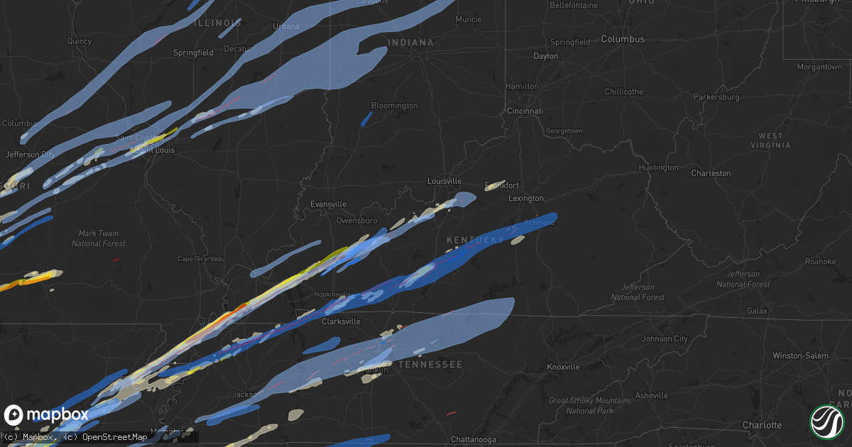
Hail Map in Kentucky on December 10, 2021
Get this storm
December 10 map
$229
one time, instant access
Download today. No call, no setup
Keep the $229
Bought the map and want the full workflow? Apply the entire $229 to a subscription within 7 days. None of it is wasted.
Every map, not just this one
This buys you this map. Subscription and you get every map we run, in the markets you choose from a few cities to whole states to nationwide. Plus real-time alerts the moment a storm fires.
Contact data
Name, contact info, occupancy, even credit band for addresses in the footprint. You go from where it hit to who to call.
Become the source they trust
Unlimited branding weather history reports on demand. You already have the documented answer ready for the property owner, and you are the one who showed up with it.
Property data and RoofTrace estimates
Pull up any address you have got, its value and the exact code rules for that jurisdiction, straight from One Click Code. Then RoofTrace estimates the squares, pitch, and roof value, priced the way you price.
Storm reports in Kentucky
Kentucky
| Date | Description |
|---|---|
| 12/10/20215:48 AM CST | Two trees were blown down on scaffold cane road near the madison county line. The event time is estimated from radar. |
| 12/10/20215:44 AM CST | 2 trees were blown down in the keavy community. |
| 12/10/20215:44 AM CST | Trees on powerlines along hightop road. Time estimated from radar. |
| 12/10/20215:44 AM CST | A tree was blown down along possum kingdom road in the brodhead community. The event time is estimated from radar. |
| 12/10/20215:35 AM CST | Tree blocking laurel cemetery road. Time estimated from radar. |
| 12/10/20215:32 AM CST | Tree reported down on murphy ridge road. Time estimated from radar. |
| 12/10/20215:31 AM CST | Tree reported down on round top rd. Time estimated from radar. |
| 12/10/20215:15 AM CST | Tree down along highway 92 west near wayne/mccreary county line. Time estimated from radar. |
| 12/10/20215:12 AM CST | The bowling green kentucky mesonet measured a wind gust of 75mph. |
| 12/10/20215:10 AM CST | Tree down on highway 167. Time estimated from radar. |
| 12/10/20215:07 AM CST | Power lines downed in burnside at the intersection of cliffside and cumberland drives. Time estimated from radar. |
| 12/10/20215:05 AM CST | Tree downed along with power lines blocking both lanes of highway 1674. Time estimated off radar. |
| 12/10/20215:00 AM CST | Tree down blocking highway 761 near nancy. Time estimated off radar. |
| 12/10/20215:00 AM CST | Tree across highway 1619. Time estimated from radar. |
| 12/10/20215:00 AM CST | Trees across powerlines in vicinity of marcus lane and bertram hollow road. Time estimated from radar. |
| 12/10/20215:00 AM CST | Tree down on highway 1009. Time estimated from radar. |
| 12/10/20214:56 AM CST | Very large tree across adair street. Time estimated from radar. |
| 12/10/20214:56 AM CST | Trees down on highway 3284. Time estimated from radar. |
| 12/10/20214:55 AM CST | Tree across highway 858 in the 1000 block. Time estimated from radar. |
| 12/10/20214:55 AM CST | Tree reported down along highway 22. Time estimated from radar. |
| 12/10/20214:55 AM CST | Corrects previous tstm wnd dmg report from hidalgo. Tree reported down along highway 200. Time estimated from radar. |
| 12/10/20214:49 AM CST | Trees down across muri road. Time estimated from radar. |
| 12/10/20214:35 AM CST | Tree over paint creek road in the 2500 block. Time estimated from radar. |
| 12/10/20214:33 AM CST | Tree on 3 phase powerline along spout springs road. Road is closed and repairs are ongoing. Time estimated from radar. |
| 12/10/20214:30 AM CST | Damage to barn outside of the vernon community. Time estimated based on radar. |
| 12/10/20214:25 AM CST | Tree down along 7200 block of hardwicks creek rd. Time estimate from radar. |
| 12/10/20214:20 AM CST | Trees were blown down along heights avenue within the city of morehead. Also scaffolding was blown down near 200 flemingsburg road. The event time is radar estimated. |
| 12/10/20214:17 AM CST | Trees down blocking roadway. |
| 12/10/20214:13 AM CST | Multiple trees and powerlines down. |
| 12/10/20214:07 AM CST | A tree was blown down in the kendall springs community. The time of the event is radar estimated. |
| 12/10/20214:03 AM CST | Trees and powerlines down near stanford and western portions of county. |
| 12/10/20213:53 AM CST | Power line downed along pottersville rd. Time estimated from radar. |
| 12/10/20213:47 AM CST | Tree down on powerline along brush creek rd. Time estimated from radar. |
| 12/10/20213:34 AM CST | Report from mping: homes/buildings completely destroyed. |
| 12/10/20213:30 AM CST | Downed tree blocking roadway near exit 95 on i-75. |
| 12/10/20213:30 AM CST | Tree damage... Time estimated by radar. |
| 12/10/20213:30 AM CST | Downed power lines and numerous people without power. Time estimated by radar. |
| 12/10/20213:23 AM CST | Trees/wires down in the bagdad/waddy area. |
| 12/10/20213:21 AM CST | At 921 PM CST, severe thunderstorms were located along a line extending from 7 miles south of Ware to near Hay-Wood City, moving northeast at 60 mph. HAZARD...60 mph wind gusts. SOURCE...Radar indicated. IMPACT...Expect damage to roofs, siding, and trees. Severe thunderstorms will be near... Anna, Jonesboro and Dongola around 930 PM CST. Olive Branch and Horseshoe Lake Conservation Area around 935 PM CST. Mounds around 940 PM CST.Other locations in the path of these severe thunderstorms includeGoreville, Tamms and Lake Of Egypt Area.This includes the following highways... Interstate 24 in Illinois between Mile Markers 6 and 12. Interstate 57 in Illinois between Mile Markers 1 and 35. Interstate 57 in Missouri between Mile Markers 18 and 21. Interstate 55 between Mile Markers 71 and 91. |
| 12/10/20213:02 AM CST | Boyle county airport had 3 hangers totally destroyed with 25 aircraft damaged. Time estimated based on radar. |
| 12/10/20212:53 AM CST | At 853 PM CST, severe thunderstorms were located along a line extending from near Dudley to Campbell, moving northeast at 60 mph. HAZARD...60 mph wind gusts. SOURCE...Radar indicated. IMPACT...Expect damage to roofs, siding, and trees. Severe thunderstorms will be near... Dexter and Bernie around 900 PM CST. Parma, Essex and Risco around 910 PM CST.Other locations in the path of these severe thunderstorms includeMorehouse, Sikeston, Lilbourn, Canalou, Miner and Matthews.This includes the following highways... Interstate 57 in Missouri near Mile Marker 1. Interstate 55 between Mile Markers 39 and 74. |
| 12/10/20212:35 AM CST | A few trees and poles down on salt river rd. |
| 12/10/20212:32 AM CST | Downed trees and lines blocking road on herbert turner road just off 31w. |
| 12/10/20212:24 AM CST | At 822 PM CST, a severe thunderstorm was located 9 miles east of Whitesville, moving northeast at 50 mph. HAZARD...60 mph wind gusts. SOURCE...Radar indicated. IMPACT...Expect damage to roofs, siding, and trees. This severe thunderstorm will be near... Hardinsburg around 840 PM CST. |
| 12/10/20212:22 AM CST | Emergency manager report of collapsed structure with people trapped on feather creek rd north of campbellsville in northern taylor county. |
| 12/10/20212:05 AM CST | The munfordville kentucky mesonet station reported a wind gust of 74mph. |
| 12/10/20211:20 AM CST | Corrects previous tstm wnd gst report from 2 nw plano. The bowling green kentucky mesonet measured a wind gust of 75mph. |
| 12/10/20211:15 AM CST | Multiple reports of damaged or collapsed structures due to tornado. People trapped. Damage to the corvette plant with fire on its roof. |
| 12/10/20211:01 AM CST | Trees down... Power outages... Structural damage to buildings and mobile homes. Report number 2 from the area with same damage. Time estimated by radar. |
| 12/10/20211:01 AM CST | Trees down... Power outages... Structural damage to buildings and mobile homes. |
| 12/10/202112:50 AM CST | Social media pictures shows structural damage to two different buildings... Trees blown across old louisville road. Time estimated by radar. |
| 12/10/202112:30 AM CST | Many trees and powerlines down from shepherdsville to mt. Washington. |
| 12/10/202112:15 AM CST | Possible tornado just southwest of lafayette. |
| 12/10/202112:12 AM CST | Reports of many power lines down... Trees down... And structural damage to central - southeast meade county. |
| 12/09/202111:49 PM CST | Dispatch reports lots of structural damage to areas north of hartford... Ky. |
| 12/09/202111:45 PM CST | Reports of tree down on 992. |
| 12/09/202111:32 PM CST | Report of large tree down in cloverport on 105. |
| 12/09/202110:57 PM CST | Semi and cars flipped off interstate 69 near earlington. |
| 12/09/202110:52 PM CST | Train cars knocked off track near the community of barnsley. |
| 12/09/202110:52 PM CST | Trees and power lines/poles down and structural damage in barnsley. |
| 12/09/202110:52 PM CST | Possible rain wrapped tornado between mortons gap and earlington. |
| 12/09/202110:40 PM CST | Major damage with buildings leveled... Multiple injuries. |
| 12/09/20219:45 PM CST | A mobile home on jackson school road was completely destroyed. A nearby garage was swept off its foundation. Possible tornado. |
| 12/09/20219:27 PM CST | Major damage reported in mayfield. No further details available at this time. |
| 12/09/20219:24 PM CST | Mesonet station pryb mayfield ky 6 sw. |
| 12/09/20219:01 PM CST | Damage reported in cayce to a cafe and the fire department. |
| 12/09/20218:55 PM CST | A local report indicates 1.75 inch wind near 4 S HICKMAN |
| 12/09/20218:45 PM CST | Damage to hardware store on west everly bros. Blvd. |
| 12/09/20218:39 PM CST | Debris from homes and billboards along the west kentucky parkway just west of central city. |
| 12/09/20218:38 PM CST | Power flashes just north of the west kentucky parkway just west of central city. Power is out. |
All States Impacted by Hail Map on December 10, 2021
Cities Impacted by Hail Map on December 10, 2021
- Texarkana, TX
- Griffithville, AR
- Searcy, AR
- Urbana, MO
- Tunas, MO
- Macks Creek, MO
- Avery, TX
- Clarksville, TX
- De Kalb, TX
- Foreman, AR
- Haworth, OK
- Willow Springs, MO
- Cabool, MO
- Memphis, TN
- Branch, AR
- Bogata, TX
- Columbia, MO
- Hartsburg, MO
- Ashland, MO
- Prairie Grove, AR
- Summers, AR
- Lincoln, AR
- Talco, TX
- Tiptonville, TN
- Meta, MO
- Linn Creek, MO
- Brumley, MO
- Camdenton, MO
- Kaiser, MO
- Henley, MO
- Westphalia, MO
- Ulman, MO
- Montreal, MO
- Jefferson City, MO
- Eldon, MO
- Tuscumbia, MO
- Iberia, MO
- Saint Elizabeth, MO
- Eugene, MO
- Saint Thomas, MO
- Nashville, AR
- Ozan, AR
- McCaskill, AR
- Murfreesboro, AR
- Ashdown, AR
- Arkadelphia, AR
- Columbus, AR
- Mineral Springs, AR
- Prescott, AR
- Blevins, AR
- Antoine, AR
- Saratoga, AR
- Lockesburg, AR
- Okolona, AR
- Delight, AR
- Shepherdsville, KY
- Lebanon Junction, KY
- West Point, KY
- Seligman, MO
- Mountain Pine, AR
- Hot Springs National Park, AR
- Hot Springs Village, AR
- Manila, AR
- Finley, TN
- Island, KY
- Luxora, AR
- Brookland, AR
- Leachville, AR
- Union City, TN
- Princeton, KY
- Eddyville, KY
- Livermore, KY
- Portageville, MO
- Blytheville, AR
- Caraway, AR
- Ridgely, TN
- Troy, TN
- Harrisburg, AR
- Bremen, KY
- Dyersburg, TN
- Mortons Gap, KY
- Etowah, AR
- Osceola, AR
- Hornersville, MO
- Whitesville, KY
- Hickman, KY
- Lake City, AR
- Beedeville, AR
- Earlington, KY
- Hartford, KY
- Benton, KY
- Hornbeak, TN
- Keiser, AR
- Gobler, MO
- Cherry Valley, AR
- Hayti, MO
- Fancy Farm, KY
- Halls, TN
- Fulton, KY
- Augusta, AR
- Centertown, KY
- Kennett, MO
- Cash, AR
- Fisher, AR
- Wingo, KY
- Gilbertsville, KY
- Weiner, AR
- Calvert City, KY
- Trumann, AR
- Black Oak, AR
- Dawson Springs, KY
- Hickory, KY
- Jonesboro, AR
- Kuttawa, KY
- Monette, AR
- Hickory Ridge, AR
- Madisonville, KY
- Steele, MO
- White Plains, KY
- Symsonia, KY
- Bragg City, MO
- Caruthersville, MO
- Mayfield, KY
- Sacramento, KY
- Grand Rivers, KY
- McCrory, AR
- Bay, AR
- Newport, AR
- Arbyrd, MO
- Lepanto, AR
- Amagon, AR
- Clinton, KY
- Utica, KY
- Pea Ridge, AR
- Henderson, TX
- Jacksonville, AR
- Little Rock Air Force Base, AR
- Deport, TX
- Tupelo, MS
- Mooreville, MS
- Saltillo, MS
- Dover, TN
- Cadiz, KY
- Bumpus Mills, TN
- Cabot, AR
- Sherwood, AR
- Ward, AR
- Lonoke, AR
- Beebe, AR
- McRae, AR
- Austin, AR
- Long Lane, MO
- Moro, AR
- Forrest City, AR
- Brinkley, AR
- Haynes, AR
- Clarendon, AR
- Marianna, AR
- Gallatin, TN
- Leslie, MO
- Farmersville, TX
- Nevada, TX
- Greenville, IL
- Smithboro, IL
- Huntsville, AR
- Red Bay, AL
- Newbern, TN
- Dyer, TN
- Dennis, MS
- Marietta, MS
- Mantachie, MS
- Belden, MS
- New Site, MS
- Guntown, MS
- Belmont, MS
- Baldwyn, MS
- Vina, AL
- Fulton, MS
- Russellville, AL
- Golden, MS
- Shelbyville, KY
- Bagdad, KY
- Waddy, KY
- Frankfort, KY
- Gentry, AR
- Twin Oaks, OK
- Colcord, OK
- Bella Vista, AR
- Oaks, OK
- Kansas, OK
- Gravette, AR
- Decatur, AR
- Bentonville, AR
- Centerton, AR
- Hiwasse, AR
- Garfield, AR
- Bath Springs, TN
- Waynesboro, TN
- Savannah, TN
- Olivehill, TN
- Clifton, TN
- Gleason, TN
- Puryear, TN
- Dresden, TN
- Paris, TN
- Cottage Grove, TN
- Mountain Grove, MO
- Lamar, MS
- Michigan City, MS
- Ashland, MS
- Lebanon, MO
- Lancaster, KY
- Crab Orchard, KY
- Stanford, KY
- Trenton, KY
- Fort Campbell, KY
- Oak Grove, KY
- Pembroke, KY
- Marthasville, MO
- New Haven, MO
- Gerald, MO
- Washington, MO
- Rogersville, MO
- Marshfield, MO
- Strafford, MO
- Thompsons Station, TN
- Franklin, TN
- Brownstown, IL
- Saint Elmo, IL
- Gurdon, AR
- Kenton, TN
- Trimble, TN
- Owensville, MO
- Mountain View, MO
- Vanzant, MO
- Summersville, MO
- Elk Creek, MO
- Yukon, MO
- Drury, MO
- Nettleton, MS
- Eldridge, MO
- Plantersville, MS
- Amory, MS
- Park City, KY
- Smiths Grove, KY
- Cave City, KY
- Horse Cave, KY
- Watertown, TN
- Gordonsville, TN
- Lebanon, TN
- Sheridan, AR
- Washington, AR
- Leola, AR
- Carthage, AR
- Emmet, AR
- Hope, AR
- Sparkman, AR
- Elkton, KY
- Hopkinsville, KY
- Guthrie, KY
- Mammoth Cave, KY
- Brownsville, KY
- Oakland, KY
- Rocky Hill, KY
- Bowling Green, KY
- Star City, AR
- Rison, AR
- Auburn, KY
- Russellville, KY
- Olmstead, KY
- Lewisburg, KY
- Texarkana, AR
- Subiaco, AR
- Paris, AR
- New Blaine, AR
- Scranton, AR
- Falls Of Rough, KY
- Harned, KY
- Garfield, KY
- Hardinsburg, KY
- Paint Lick, KY
- Miller, MO
- Ash Grove, MO
- Everton, MO
- Caddo Mills, TX
- Guston, KY
- Holly Springs, MS
- Falkner, MS
- Walnut, MS
- Parsons, TN
- Lobelville, TN
- Centerville, TN
- Linden, TN
- Middleton, TN
- Ramer, TN
- Stantonville, TN
- Pocahontas, TN
- Tiplersville, MS
- Adamsville, TN
- Selmer, TN
- Sulphur Bluff, TX
- Lake Creek, TX
- Cooper, TX
- Effingham, IL
- Altamont, IL
- Chesterfield, MO
- Saint Louis, MO
- La Vergne, TN
- Paron, AR
- Walnut Grove, MO
- South Greenfield, MO
- Greenfield, MO
- Lockwood, MO
- Vienna, MO
- Ava, MO
- Beaufort, MO
- Royse City, TX
- Celeste, TX
- Lavon, TX
- Greenville, TX
- Rockwall, TX
- Oxford, MS
- Paris, MS
- Pontotoc, MS
- Water Valley, MS
- Thaxton, MS
- Ecru, MS
- Ballwin, MO
- Cuba, MO
- Rosebud, MO
- Pomona, MO
- El Paso, AR
- Maryland Heights, MO
- Granite City, IL
- Pacific, MO
- East Alton, IL
- Hartford, IL
- Saint Ann, MO
- South Roxana, IL
- Roxana, IL
- Wildwood, MO
- Sardis, MS
- Crenshaw, MS
- Maumelle, AR
- Little Rock, AR
- Nolensville, TN
- Brentwood, TN
- Antioch, TN
- Bonnerdale, AR
- Coffeen, IL
- Falcon, MO
- Grovespring, MO
- Custer, KY
- Ekron, KY
- Irvington, KY
- Clermont, KY
- Radcliff, KY
- Vine Grove, KY
- Rineyville, KY
- Cecilia, KY
- Fort Knox, KY
- Mount Washington, KY
- Canton, TX
- Alexander, AR
- Lyles, TN
- Bon Aqua, TN
- Sledge, MS
- Bland, MO
- Belle, MO
- Rives, TN
- Valley Park, MO
- Eureka, MO
- Union, MO
- Mount Pleasant, TX
- Tremont, MS
- Washburn, MO
- Cassville, MO
- Exeter, MO
- Higginson, AR
- Bald Knob, AR
- Charleston, AR
- Ratcliff, AR
- Inverness, MS
- Goodlettsville, TN
- Madison, TN
- Hendersonville, TN
- Cottontown, TN
- Aubrey, AR
- Cameron, OK
- Vichy, MO
- Stilwell, OK
- Westville, OK
- Aldrich, MO
- Dadeville, MO
- Golden City, MO
- Brighton, MO
- Sarcoxie, MO
- Morrisville, MO
- Reeds, MO
- La Russell, MO
- Carthage, MO
- Bolivar, MO
- Magnolia, KY
- Mount Sherman, KY
- Herndon, KY
- Elkland, MO
- Windyville, MO
- Phillipsburg, MO
- Buffalo, MO
- Nashville, TN
- Royal, AR
- Wister, OK
- Judsonia, AR
- Louisburg, MO
- Half Way, MO
- Walshville, IL
- Panama, IL
- Hillsboro, IL
- Donnellson, IL
- Sullivan, MO
- North Little Rock, AR
- Benton, AR
- Avilla, MO
- Sharon, TN
- Martin, TN
- Palmersville, TN
- Chidester, AR
- Rutherford, TN
- Cordova, TN
- Collierville, TN
- Germantown, TN
- Eads, TN
- Florissant, MO
- Frankford, MO
- Louisiana, MO
- Norwood, MO
- Greenbrier, AR
- Wilton, AR
- Donaldson, AR
- Alleene, AR
- Poteau, OK
- Howe, OK
- Olaton, KY
- New Douglas, IL
- Sorento, IL
- Fillmore, IL
- Stoutland, MO
- Richland, MO
- Dike, TX
- Hindsville, AR
- Primm Springs, TN
- Buffalo, KY
- Campbellsville, KY
- Mayflower, AR
- Garner, AR
- Conway, AR
- Roland, AR
- Lonsdale, AR
- Kensett, AR
- Vilonia, AR
- Spring Hill, TN
- Columbia, TN
- College Grove, TN
- Magazine, AR
- Rowlett, TX
- Leitchfield, KY
- Hudson, KY
- Beaver Dam, KY
- Westview, KY
- McDaniels, KY
- Nortonville, KY
- Central City, KY
- Graham, KY
- Water Valley, KY
- Dundee, KY
- Horse Branch, KY
- McHenry, KY
- Saint Charles, KY
- Fordsville, KY
- Oil Trough, AR
- Bradford, AR
- Thida, AR
- Swifton, AR
- Pleasant Plains, AR
- Mount Vernon, AR
- Letona, AR
- Tuckerman, AR
- Pangburn, AR
- Bono, AR
- Heber Springs, AR
- Romance, AR
- Rose Bud, AR
- Des Arc, AR
- Carlisle, AR
- Marked Tree, AR
- Altus, AR
- Jerusalem, AR
- Lamar, AR
- Greenwood, AR
- Knoxville, AR
- Dover, AR
- London, AR
- Ozark, AR
- Coal Hill, AR
- Lavaca, AR
- Hartman, AR
- Pelsor, AR
- Clarksville, AR
- Delaware, AR
- Fort Smith, AR
- Hector, AR
- Russellville, AR
- Malvern, AR
- Prattsville, AR
- Redfield, AR
- Hensley, AR
- Friendship, AR
- Bauxite, AR
- Poyen, AR
- Traskwood, AR
- Hughes, AR
- Heth, AR
- Marion, AR
- Proctor, AR
- West Memphis, AR
- Ada, OH
- Alger, OH
- Fredonia, KY
- Edwardsville, IL
- Reynolds Station, KY
- Crofton, KY
- Caneyville, KY
- Powderly, KY
- Greenville, KY
- Rockport, KY
- Paducah, KY
- Golconda, IL
- Smithland, KY
- Metropolis, IL
- Clay, KY
- West Paducah, KY
- Marion, KY
- Providence, KY
- Brookport, IL
- Hampton, KY
- Dixon, KY
- Burna, KY
- Salem, KY
- Louisville, KY
- Coxs Creek, KY
- Taylorsville, KY
- Fisherville, KY
- Rockfield, KY
- Nunnelly, TN
- Ashland City, TN
- Beech Bluff, TN
- New Johnsonville, TN
- Kingston Springs, TN
- Huron, TN
- Charlotte, TN
- White Bluff, TN
- Gainesboro, TN
- Alpine, TN
- Jackson, TN
- Darden, TN
- Yuma, TN
- Pegram, TN
- Hestand, KY
- Chestnut Mound, TN
- Lafayette, TN
- Sugar Tree, TN
- Holladay, TN
- Cedar Grove, TN
- Waverly, TN
- Hurricane Mills, TN
- Buffalo Valley, TN
- Henderson, TN
- Albany, KY
- Whites Creek, TN
- Pall Mall, TN
- Red Boiling Springs, TN
- Livingston, TN
- Elmwood, TN
- Tompkinsville, KY
- Toone, TN
- Oakland, TN
- Stearns, KY
- Monroe, TN
- Whiteville, TN
- Wildersville, TN
- Only, TN
- Moss, TN
- Hartsville, TN
- Baxter, TN
- Mount Juliet, TN
- Cookeville, TN
- Bethpage, TN
- Joelton, TN
- Byrdstown, TN
- Fairview, TN
- Celina, TN
- Mercer, TN
- Whitleyville, TN
- Dixon Springs, TN
- Carthage, TN
- Mason, TN
- Granville, TN
- Somerville, TN
- Dickson, TN
- Brush Creek, TN
- Medon, TN
- Burns, TN
- Westport, TN
- McEwen, TN
- Burkesville, KY
- Hermitage, TN
- Riddleton, TN
- Luray, TN
- Pinson, TN
- Bloomington Springs, TN
- Old Hickory, TN
- Camden, TN
- Rickman, TN
- Allons, TN
- Castalian Springs, TN
- Hickman, TN
- Jamestown, TN
- Pleasant Shade, TN
- Alpha, KY
- Monticello, KY
- Lexington, TN
- Hilham, TN
- Arlington, TN
- Bolivar, TN
- Cumberland Furnace, TN
- Cunningham, TN
- Vanleer, TN
- Erin, TN
- Danville, KY
- Irvine, KY
- Edmonton, KY
- Waco, KY
- Parksville, KY
- New Concord, KY
- Glasgow, KY
- Center, KY
- Canmer, KY
- Allensville, KY
- Munfordville, KY
- Hardyville, KY
- Clay City, KY
- Buchanan, TN
- Hustonville, KY
- Perryville, KY
- Greenfield, TN
- Winchester, KY
- Summersville, KY
- Greensburg, KY
- Morgantown, KY
- La Fayette, KY
- Franklin, KY
- Clarksville, TN
- Alvaton, KY
- Knob Lick, KY
- Henry, TN
- Richmond, KY
- Bonnieville, KY
- Bradfordsville, KY
- Dell, AR
- Junction City, KY
- Big Rock, TN
- Lebanon, KY
- Woodburn, KY
- Adairville, KY
- Gravel Switch, KY
- Gruetli Laager, TN
- Palmer, TN
- Tracy City, TN
- Coalmont, TN
- Prospect, TN
- Ardmore, TN
- Athens, AL
- Town Creek, AL
- Minor Hill, TN
- Tishomingo, MS
- Sheffield, AL
- Five Points, TN
- Taft, TN
- Dellrose, TN
- Ardmore, AL
- Cherokee, AL
- Muscle Shoals, AL
- Iuka, MS
- Tuscumbia, AL
- Booneville, MS
- Lexington, AL
- Lester, AL
- Florence, AL
- Elkmont, AL
- Killen, AL
- Leighton, AL
- Anderson, AL
- Fayetteville, TN
- Rogersville, AL
- Winthrop, AR
- Clever, MO
- Billings, MO
- Marionville, MO
- Newburg, MO
- Fort Leonard Wood, MO
- Devils Elbow, MO
- Rolla, MO
- Saint Robert, MO
- Laquey, MO
- Duke, MO
- Fair Grove, MO
- Springfield, MO
- Conway, MO
- Waynesville, MO
- Dixon, MO
- Niangua, MO
- Edgar Springs, MO
- Nixa, MO
- Ozark, MO
- Martinsville, IL
- Lebanon, IN
- Alhambra, IL
- Venice, IL
- Veedersburg, IN
- Kansas, IL
- Ramsey, IL
- Staunton, IN
- Cory, IN
- West Terre Haute, IN
- Montezuma, IN
- Roachdale, IN
- Greenup, IL
- Shelbyville, IL
- Crawfordsville, IN
- Bridgeton, IN
- Labadie, MO
- Fillmore, IN
- Madison, IL
- Tipton, IN
- Greentown, IN
- Mattoon, IL
- Windsor, IL
- Russellville, IN
- Strasburg, IL
- Riley, IN
- Danville, IN
- Metcalf, IL
- Westfield, IL
- Cowden, IL
- Terre Haute, IN
- Atlanta, IN
- Fairmount, IN
- Dennison, IL
- Montpelier, IN
- Summitville, IN
- Gas City, IN
- Marion, IN
- Greencastle, IN
- Kingman, IN
- Alamo, IN
- Brocton, IL
- Toledo, IL
- Frankfort, IN
- Marshall, IL
- North Salem, IN
- Goldsmith, IN
- Colfax, IN
- Gray Summit, MO
- Hindsboro, IL
- Swayzee, IN
- Oconee, IL
- Darlington, IN
- Vermilion, IL
- Neoga, IL
- Trilla, IL
- Teutopolis, IL
- Jonesboro, IN
- Chrisman, IL
- New Goshen, IN
- Waveland, IN
- Newman, IL
- Alexandria, IN
- Oakland, IL
- Brazil, IN
- Villa Ridge, MO
- Beecher City, IL
- Bingham, IL
- Universal, IN
- Clinton, IN
- Pana, IL
- Cicero, IN
- Coatesville, IN
- Saint James, MO
- Kempton, IN
- Whitestown, IN
- Hamel, IL
- Mecca, IN
- Arcola, IL
- Knightsville, IN
- Covington, IN
- Bloomingdale, IN
- Warren, IN
- Upland, IN
- Tower Hill, IL
- Waynetown, IN
- Harmony, IN
- Lerna, IL
- Humboldt, IL
- Hartford City, IN
- Ridge Farm, IL
- Worden, IL
- Windfall, IN
- Paris, IL
- Mode, IL
- Perrysville, IN
- Dana, IN
- Arcadia, IN
- Carbon, IN
- Shumway, IL
- Charleston, IL
- Stewardson, IL
- Rosedale, IN
- Crocker, MO
- Redmon, IL
- Rockville, IN
- Montrose, IL
- Cayuga, IN
- Van Buren, IN
- Kirklin, IN
- Jamestown, IN
- Casey, IL
- Marshall, IN
- Bainbridge, IN
- Sigel, IL
- Elwood, IN
- Lakewood, IL
- Gays, IL
- Hume, IL
- Glen Carbon, IL
- Herrick, IL
- Reelsville, IN
- Hillsboro, IN
- Hillsdale, IN
- Sheridan, IN
- Ladoga, IN
- Ashmore, IL
- Thorntown, IN
- Kingdom City, MO
- Laddonia, MO
- Delavan, IL
- Mexico, MO
- Rockport, IL
- Fulton, MO
- Griggsville, IL
- Pleasant Hill, IL
- Mount Sterling, IL
- Chandlerville, IL
- Mason City, IL
- New Holland, IL
- Meredosia, IL
- Versailles, IL
- Bluffs, IL
- Arenzville, IL
- Ashland, IL
- San Jose, IL
- Auxvasse, MO
- Wellsville, MO
- Oakford, IL
- Middletown, MO
- Virginia, IL
- New Bloomfield, MO
- Easton, IL
- Perry, IL
- Armington, IL
- Minier, IL
- Beardstown, IL
- Martinsburg, MO
- Hopedale, IL
- Bowling Green, MO
- New Salem, IL
- Pittsfield, IL
- New Canton, IL
- Concord, IL
- Petersburg, IL
- Barry, IL
- Benton City, MO
- Chambersburg, IL
- Greenview, IL
- Emden, IL
- Baylis, IL
- Chapin, IL
- Vandalia, MO
- Curryville, MO
- Hartsburg, IL
- Freeburg, MO
- Lake Saint Louis, MO
- Wentzville, MO
- Linn, MO
- Brighton, IL
- Wright City, MO
- Hermann, MO
- Loose Creek, MO
- Morrison, MO
- Troy, MO
- Brussels, IL
- Rhineland, MO
- Jonesburg, MO
- Shipman, IL
- Truesdale, MO
- Moscow Mills, MO
- Chamois, MO
- Batchtown, IL
- Jerseyville, IL
- Golden Eagle, IL
- Bonnots Mill, MO
- Foristell, MO
- Dow, IL
- Foley, MO
- Portage Des Sioux, MO
- Elsah, IL
- Fieldon, IL
- Warrenton, MO
- Carlinville, IL
- Godfrey, IL
- Winfield, MO
- Piasa, IL
- Old Monroe, MO
- Berger, MO
- Medora, IL
- Fidelity, IL
- Grafton, IL
- O'Fallon, MO
- Moweaqua, IL
- Sawyerville, IL
- Bringhurst, IN
- Westpoint, IN
- Galveston, IN
- Bridgeton, MO
- Assumption, IL
- Collison, IL
- Monticello, IN
- Hazelwood, MO
- Dorsey, IL
- Sidney, IL
- Mount Olive, IL
- Thomasboro, IL
- Pesotum, IL
- Bethalto, IL
- Brookston, IN
- Pine Village, IN
- Royal Center, IN
- Alton, IL
- La Place, IL
- Tuscola, IL
- Rossville, IL
- Argenta, IL
- Champaign, IL
- Alvin, IL
- Fithian, IL
- Mt Zion, IL
- West Lafayette, IN
- Staunton, IL
- Benld, IL
- Irving, IL
- Flora, IN
- Augusta, MO
- Otterbein, IN
- Bismarck, IL
- Dalton City, IL
- Sadorus, IL
- Fairmount, IL
- Cerro Gordo, IL
- Attica, IN
- Saint Peters, MO
- Walton, IN
- Monticello, IL
- Camden, IN
- Burnettsville, IN
- Logansport, IN
- Ivesdale, IL
- Urbana, IL
- Rossville, IN
- Harvel, IL
- Yeoman, IN
- Ogden, IL
- Saint Joseph, IL
- Saint Charles, MO
- Tolono, IL
- Oakwood, IL
- Williamsport, IN
- West Lebanon, IN
- Danville, IL
- Henning, IL
- Penfield, IL
- Potomac, IL
- Defiance, MO
- Taylorville, IL
- Morrisonville, IL
- Butler, IL
- Savoy, IL
- Delphi, IN
- Gillespie, IL
- Battle Ground, IN
- Buck Creek, IN
- Hammond, IL
- Raymond, IL
- Wood River, IL
- Wilsonville, IL
- Nokomis, IL
- Owaneco, IL
- West Alton, MO
- Muncie, IL
- Lafayette, IN
- Decatur, IL
- Lovington, IL
- Gifford, IL
- Lucerne, IN
- Moro, IL
- Homer, IL
- Earth City, MO
- Atwood, IL
- Idaville, IN
- Litchfield, IL
- Armstrong, IL
- Macon, IL
- Cottage Hills, IL
- Witt, IL
- Chalmers, IN
- Philo, IL
- Bunker Hill, IL
- Royal, IL
- Bement, IL
- Morton, IL
- Congerville, IL
- Goodfield, IL
- Secor, IL
- Deer Creek, IL
- El Paso, IL
- Pekin, IL
- Green Valley, IL
- Eureka, IL
- Mackinaw, IL
- Tremont, IL
- Carlock, IL
- Chestnut, IL
- Latham, IL
- Kenney, IL
- Mount Pulaski, IL
- Maroa, IL
- Clinton, IL
- Knox, IN
- Hanna, IN
- Rensselaer, IN
- Demotte, IN
- Valparaiso, IN
- Union Mills, IN
- North Liberty, IN
- Kingsford Heights, IN
- La Crosse, IN
- La Porte, IN
- Hamlet, IN
- Walkerton, IN
- Kouts, IN
- Fair Oaks, IN
- Wheatfield, IN
- Wanatah, IN
- New Carlisle, IN
- Mill Creek, IN
- South Bend, IN
- Francesville, IN
- Medaryville, IN
- Brook, IN
- Winamac, IN
- Morocco, IN
- Monterey, IN
- North Judson, IN
- Lyons, IN
- Bloomfield, IN
- Newberry, IN
- Highland, IL
- Mulberry Grove, IL
- Vandalia, IL
- Jewett, IL
- Pocahontas, IL
- Watson, IL
- Cedar Lake, IN
- Crown Point, IN
- Reeds Spring, MO
- Walnut Shade, MO
- Redford, MO
- Ellington, MO


