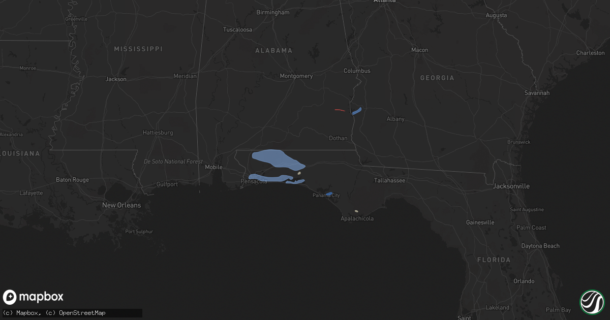
Hail Map in Georgia on November 30, 2022
Get this storm
November 30 map
$229
one time, instant access
Download today. No call, no setup
Keep the $229
Bought the map and want the full workflow? Apply the entire $229 to a subscription within 7 days. None of it is wasted.
Every map, not just this one
This buys you this map. Subscription and you get every map we run, in the markets you choose from a few cities to whole states to nationwide. Plus real-time alerts the moment a storm fires.
Contact data
Name, contact info, occupancy, even credit band for addresses in the footprint. You go from where it hit to who to call.
Become the source they trust
Unlimited branding weather history reports on demand. You already have the documented answer ready for the property owner, and you are the one who showed up with it.
Property data and RoofTrace estimates
Pull up any address you have got, its value and the exact code rules for that jurisdiction, straight from One Click Code. Then RoofTrace estimates the squares, pitch, and roof value, priced the way you price.
Storm reports in Georgia
Georgia
| Date | Description |
|---|---|
| 11/30/20228:53 AM CST | Tree down on highway 319 near mile marker 5. |
| 11/30/20228:53 AM CST | A couple of trees were blown down in colquitt county. |
| 11/30/20228:50 AM CST | Tree down along the 3000 block of lower cairo road. |
| 11/30/20228:38 AM CST | Video of a brief tornado in a field with no damage. |
| 11/30/20228:26 AM CST | Damage to a barn. |
| 11/30/20228:26 AM CST | Tree down on mooty bridge rd. Near concord dr. |
| 11/30/20227:45 AM CST | Tree down on jericho road. |
| 11/30/20227:29 AM CST | Tree down on jeterville road. |
| 11/30/20227:00 AM CST | Two trees were blown down in early county. |
| 11/30/20226:50 AM CST | Two trees were blown down in randolph county. |
| 11/30/20222:44 AM CST | At 844 AM EST/744 AM CST/, severe thunderstorms were located along a line extending from 10 miles southwest of Newton to 10 miles north of West Bainbridge to 6 miles southeast of Donalsonville to 17 miles northwest of Chattahoochee to near Marianna to 8 miles east of Chipley, moving southeast at 40 mph. HAZARD...60 mph wind gusts. SOURCE...Radar indicated. IMPACT...Expect damage to roofs, siding, and trees. Locations impacted include... Newton, Pelham, Marianna, Chipley, Bainbridge, Donalsonville, Cairo, Camilla, Baconton, Whigham, West Bainbridge, Chattahoochee, Sneads, Cottondale, Grand Ridge, Greenwood, Alford, Attapulgus, Sale City and Iron City. |
| 11/30/20221:45 AM CST | At 745 AM EST/645 AM CST/, severe thunderstorms were located along a line extending from 8 miles southeast of Fort Gaines to Columbia to near Slocomb to 8 miles south of Geneva, moving southeast at 40 mph. HAZARD...60 mph wind gusts. SOURCE...Radar indicated. IMPACT...Expect damage to roofs, siding, and trees. Locations impacted include... Colquitt, Cottonwood, Blakely, Marianna, Chipley, Graceville, Donalsonville, Bainbridge, Ashford, Arlington, Columbia, Chattahoochee, Douglasville, Centerville, Malone, Sneads, Cottondale, Grand Ridge, Greenwood and Avon. |
| 11/30/202212:09 AM CST | At 608 AM CST, severe thunderstorms were located along a line extending from near Texasville to 10 miles south of Blue Springs State Park, moving east at 45 mph. HAZARD...60 mph wind gusts. SOURCE...Radar indicated. IMPACT...Expect damage to roofs, siding, and trees. Locations impacted include... Abbeville, Shorterville, Walter F. George Lock And Dam, Barnes, Edwin, Hardwickburg, Otho, Hayes, Scottsboro Crossroads, Double Bridges, Murphy Station, Graball, Screamer, Coates, Thomas Mill Creek, Lawrenceville, Abbeville Municipal A/P and Willis Crossroads. |
| 11/29/202211:52 PM CST | At 552 AM CST, severe thunderstorms were located along a line extending from near Boot Hill to Doster, moving east at 50 mph. HAZARD...60 mph wind gusts. SOURCE...Radar indicated. IMPACT...Expect damage to roofs, siding, and trees. Locations impacted include... Eufaula, Clio, Clayton, Louisville, Blue Springs, Tyler Crossroads, Doster, Gaino, Blue Springs State Park, Osco, Texasville, Richards Crossroads, White Oak, Boot Hill, Millers Ford, Clayton Municipal Airport and Baker Hill. |
| 11/29/20229:28 PM CST | At 328 AM EST, severe thunderstorms were located along a line extending from near Buchanan to Mount Zion to near Graham, moving east at 65 mph. HAZARD...60 mph wind gusts. SOURCE...Radar indicated. IMPACT...Expect damage to roofs, siding, and trees. Locations impacted include... Newnan, Douglasville, Carrollton, City of South Fulton, Villa Rica, Fairburn, Bremen, Palmetto, Temple, Bowdon, Mount Zion, Whitesburg, Waco, Ephesus, Centralhatchee, Roopville, Lithia Springs, Chattahoochee Hills, East Newnan and Plant Yates. |
| 11/29/20227:56 PM CST | At 156 AM CST, severe thunderstorms were located along a line extending from Jacksonville State University to near Oxford Lake to near Waldo, moving east at 60 mph. HAZARD...60 mph wind gusts. SOURCE...Radar indicated. IMPACT...Expect damage to roofs, siding, and trees. Locations impacted include... Heflin, Ranburne, Fruithurst, Edwardsville, Woodland, Morrison Cross Roads, Barfield, Corinth, Muscadine, Abernathy, Fosters Cross Roads, Delta, Mars Hills, Mount Cheaha, Graham, Newell, Coleman Lake And Campground, Trickem, Lake Cleburne and Liberty Hill. |
Cities Impacted by Hail Map on November 30, 2022
- Defuniak Springs, FL
- Eastpoint, FL
- Shalimar, FL
- Milton, FL
- Pensacola, FL
- Fort Walton Beach, FL
- Niceville, FL
- Hurlburt Field, FL
- Valparaiso, FL
- Mary Esther, FL
- Eglin Afb, FL
- Gulf Breeze, FL
- Navarre, FL
- Wing, AL
- Crestview, FL
- Laurel Hill, FL
- Baker, FL
- Holt, FL
- Jay, FL
- Brewton, AL
- Destin, FL
- Santa Rosa Beach, FL
- Miramar Beach, FL
- Freeport, FL
- Panama City, FL
- Eufaula, AL
- Clayton, AL
- Fort Gaines, GA
- Coleman, GA
- Morris, GA
- Cuthbert, GA


