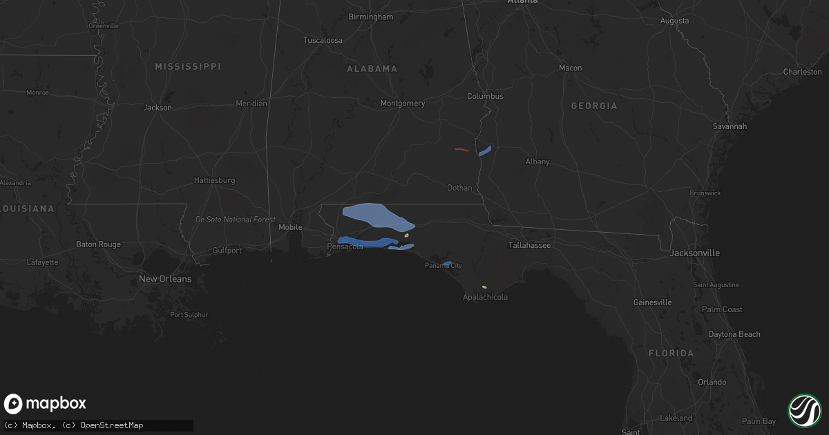
Hail Map in Florida on November 30, 2022
Get this storm
November 30 map
$229
one time, instant access
Download today. No call, no setup
Keep the $229
Bought the map and want the full workflow? Apply the entire $229 to a subscription within 7 days. None of it is wasted.
Every map, not just this one
This buys you this map. Subscription and you get every map we run, in the markets you choose from a few cities to whole states to nationwide. Plus real-time alerts the moment a storm fires.
Contact data
Name, contact info, occupancy, even credit band for addresses in the footprint. You go from where it hit to who to call.
Become the source they trust
Unlimited branding weather history reports on demand. You already have the documented answer ready for the property owner, and you are the one who showed up with it.
Property data and RoofTrace estimates
Pull up any address you have got, its value and the exact code rules for that jurisdiction, straight from One Click Code. Then RoofTrace estimates the squares, pitch, and roof value, priced the way you price.
Storm reports in Florida
Florida
| Date | Description |
|---|---|
| 11/30/202212:16 PM CST | Trees an |
| 11/30/202212:16 PM CST | Trees and tree debris damaged utility equipment along plummer grant road per the jax electric authory. The time of damage was based on radar. |
| 11/30/202212:10 PM CST | Delayed report. Tree roughly 14 inches in diameter snapped... Football training metal equipment moved by wind. |
| 11/30/202212:00 PM CST | Trees and tree debris damaged utility equipment near lyle road. Wind gusts measured in the area were 35-45 mph around the time of damage. The time was based on radar. R |
| 11/30/202211:00 AM CST | Duke energy utility company reported damage to utility equipment from trees and debris blown down onto powerlines. The time of damage was based on radar. |
| 11/30/20229:31 AM CST | Florida highway patrol reports tree down near intersection of bloxham cutoff road and wakulla springs road. |
| 11/30/20228:39 AM CST | Personal weather station gusted to 60 mph. |
| 11/30/20228:28 AM CST | Tree caused a power outage to 151 customers near gretna via talquin electric outage map. |
| 11/30/20227:50 AM CST | Trees down in the central part of |
| 11/30/20227:50 AM CST | Trees down in the central part of washington county. |
| 11/30/20227:42 AM CST | Public reported that personal weather station measured a 61 mph gust on bay grove road. |
| 11/30/20227:26 AM CST | Trees down in the northwest part of washington county. |
| 11/30/20227:15 AM CST | Trees down along highway 177. |
| 11/30/20227:15 AM CST | Emergency manager reports a tree down on a house... Resulting in structural damage. |
| 11/30/20227:13 AM CST | Trees down near spradlin road and highway 83. |
| 11/30/20227:10 AM CST | Trees down along highway 177. |
| 11/30/20226:54 AM CST | Emergency manager reports a tree down on a house... Resulting in structural damage. |
| 11/30/20226:27 AM CST | Emergency manager reports a tree and powerlines down on munson highway. |
| 11/30/20226:09 AM CST | Escambia county |
| 11/30/20225:36 AM CST | At 1136 AM EST, strong to severe thunderstorms were located near Live Oak, moving southeast at 35 mph. HAZARD...60 mph wind gusts. SOURCE...Radar indicated. IMPACT...Expect damage to roofs, siding, and trees. Locations impacted include... Lake City, Live Oak, White Springs, Suwannee Springs, Wellborn, Five Points, Winfield, Suwannee Valley, Mcalpin and Luraville. |
| 11/30/20225:05 AM CST | At 1105 AM EST, severe thunderstorms were located along a line extending from 10 miles north of Eastpoint to near Apalachicola to 9 miles west of St George Island, moving east at 35 mph. HAZARD...60 mph wind gusts and quarter size hail. SOURCE...Radar indicated. IMPACT...Hail damage to vehicles is expected. Expect wind damage to roofs, siding, and trees. Locations impacted include... Carrabelle, St George Island, Eastpoint, Apalachicola, Franklin, Carrabelle Beach, Buck Siding, Turkey Point, Royal Bluff, High Bluff, Yent Place, St George Island St Pk, Beverly, Green Point, Bay City, Lanark Village, Apalachicola Airport, Creels, Hays Place and Fort Gadsden. |
| 11/30/20224:52 AM CST | At 1051 AM EST, severe thunderstorms were located along a line extending from near Moody Air Force Base to 7 miles southwest of Lake Park, moving southeast at 40 mph. HAZARD...60 mph wind gusts. SOURCE...Radar indicated. IMPACT...Expect damage to roofs, siding, and trees. Locations impacted include... Jasper, Jennings, Statenville, Mayday, Needmore, Blue Springs and Crossroads. |
| 11/30/20223:31 AM CST | At 931 AM EST, severe thunderstorms were located along a line extending from near Riverside to near Coolidge to 8 miles southwest of Whigham, moving east at 35 mph. HAZARD...60 mph wind gusts. SOURCE...Radar indicated. IMPACT...Expect damage to roofs, siding, and trees. Locations impacted include... Nashville, Moultrie, Adel, Thomasville, Lakeland, Valdosta, Lake Park, Cairo, Quitman, Hahira, Sparks, Boston, Ray City, Ochlocknee, Pavo, Coolidge, Riverside, I-75 At Exit 16, Moody Air Force Base and Schley. |
| 11/30/20223:21 AM CST | At 921 AM EST/821 AM CST/, severe thunderstorms were located along a line extending from 9 miles east of Chattahoochee to near Greensboro to 16 miles west of Blountstown to 6 miles north of Lynn Haven to 8 miles southwest of Panama City Beach, moving southeast at 30 mph. HAZARD...60 mph wind gusts. SOURCE...Radar indicated. IMPACT...Expect damage to roofs, siding, and trees. Locations impacted include... Quincy, Tallahassee, Havana, St. Marks, Midway, Woodville, Crawfordville, Port St. Joe, Blountstown, Mexico Beach, Florida State University, Stonemill Creek, Tallahassee Comm College, Doak Campbell Stadium, Chattahoochee, Greensboro, Florida A And M, Orange, Wakulla and Wewahitchka. |
| 11/30/20222:22 AM CST | At 822 AM EST/722 AM CST/, severe thunderstorms were located along a line extending from near Chipley to 14 miles northwest of Vernon to 9 miles southeast of De Funiak Springs to near Eglin Air Force Base to near Destin, moving east at 45 mph. HAZARD...70 mph wind gusts. SOURCE...Radar indicated. IMPACT...Expect considerable tree damage. Damage is likely to mobile homes, roofs, and outbuildings. Locations impacted include... Panama City, Lynn Haven, Panama City Beach, Callaway, Vernon, Blountstown, Springfield, Mexico Beach, Hiland Park, Tyndall Air Force Base, Wewahitchka, Bradford, Parker, Altha, Wausau, Ebro, Clarksville, Allanton, Gulf Resort Beach and West Panama City. |
| 11/30/20221:13 AM CST | At 713 AM CST, severe thunderstorms were located along a line extending from 5 miles north of Niceville to 3 miles northwest of Valparaiso to near Eglin AFB to Cinco Bayou, moving east at 40 mph. HAZARD...60 mph wind gusts. SOURCE...Radar indicated. IMPACT...Expect damage to roofs, siding, and trees. Locations impacted include... Fort Walton Beach, Niceville, Destin, Eglin AFB, Valparaiso, Lake Lorraine, Shalimar and Cinco Bayou. |
| 11/30/20221:01 AM CST | At 701 AM CST, severe thunderstorms were located along a line extending from 8 miles northwest of De Funiak Springs to 7 miles east of Crestview to 9 miles north of Niceville to 8 miles north of Wright, moving east at 60 mph. HAZARD...70 mph wind gusts. SOURCE...Radar indicated. IMPACT...Expect considerable tree damage. Damage is likely to mobile homes, roofs, and outbuildings. Locations impacted include... Crestview. |
| 11/30/202212:58 AM CST | At 657 AM CST, severe thunderstorms were located along a line extending from near Webb to Cowarts to near Taylor to near Geneva, moving southeast at 30 mph. HAZARD...60 mph wind gusts. SOURCE...Radar indicated. IMPACT...Expect damage to roofs, siding, and trees. Locations impacted include... Headland, Dothan, Geneva, Hartford, Taylor, Kinsey, Ashford, Slocomb, Samson, Cowarts, Webb, Malvern, Rehobeth, Avon, Esto, Black, Haleburg, Memphis, Kellys Crossroads and Wilson Mill. |
| 11/30/202212:32 AM CST | At 631 AM CST, severe thunderstorms were located along a line extending from 3 miles northeast of Bagdad to 7 miles southeast of Pea Ridge to 3 miles east of Pensacola to Warrington, moving east at 45 mph. HAZARD...60 mph wind gusts. SOURCE...Radar indicated. IMPACT...Expect damage to roofs, siding, and trees. Locations impacted include... Pensacola, Ferry Pass, Brent, West Pensacola, Wright, Fort Walton Beach, Warrington, Niceville, Destin, Eglin AFB, Milton, Valparaiso, Gulf Breeze, Goulding, Mary Esther, Bagdad, Ocean City, Lake Lorraine, Myrtle Grove and Oriole Beach. |
| 11/30/202212:08 AM CST | At 607 AM CST, severe thunderstorms were located along a line extending from 4 miles southwest of Riverview to 8 miles southeast of Jay to 8 miles east of Molino to near Gonzalez, moving east at 65 mph. HAZARD...70 mph wind gusts. SOURCE...Radar indicated. IMPACT...Expect considerable tree damage. Damage is likely to mobile homes, roofs, and outbuildings. Locations impacted include... Crestview, Pace, Milton, Bagdad, Baker, Laurel Hill, Pea Ridge, Roeville, Floridatown and Point Baker. |
| 11/29/202211:56 PM CST | At 555 AM CST, severe thunderstorms were located along a line extending from near Doster to near Ozark to near Fort Rucker to Opp, moving southeast at 30 mph. HAZARD...60 mph wind gusts. SOURCE...Radar indicated. IMPACT...Expect damage to roofs, siding, and trees. Locations impacted include... Daleville, Elba, Geneva, Enterprise, Headland, Dothan, Fort Rucker, Ozark, Hartford, Taylor, Midland City, Kinsey, Ashford, Level Plains, Slocomb, Samson, Cowarts, Newton, Webb and New Brockton. |
| 11/29/202211:26 PM CST | At 525 AM CST, severe thunderstorms were located along a line extending from near I65 And AL 225 to 3 miles north of Stapleton to Spanish Fort to 7 miles southeast of I10 And I65, moving east at 65 mph. HAZARD...70 mph wind gusts. SOURCE...Radar indicated. IMPACT...Expect considerable tree damage. Damage is likely to mobile homes, roofs, and outbuildings. Locations impacted include... Daphne, Gonzalez, Bay Minette, Atmore, Pace, Spanish Fort, Century, Flomaton, Loxley, Stockton, Stapleton, Molino, Jay, Pollard, Riverview, Bratt, Point Baker and I65 And AL 225. |
| 11/29/20227:06 PM CST | At 105 PM EST, a severe thunderstorm was located over Nas Jax, or near Orange Park, moving east at 30 mph. HAZARD...60 mph wind gusts. SOURCE...Radar indicated. IMPACT...Expect damage to roofs, siding, and trees. Locations impacted include... Orange Park, Unf, Mandarin, Fruit Cove, Ponte Vedra Beach, Jacksonville Beach, Sawgrass, Baymeadows, Nocatee and Ortega. |
Cities Impacted by Hail Map on November 30, 2022
- Defuniak Springs, FL
- Eastpoint, FL
- Shalimar, FL
- Milton, FL
- Pensacola, FL
- Fort Walton Beach, FL
- Niceville, FL
- Hurlburt Field, FL
- Valparaiso, FL
- Mary Esther, FL
- Eglin Afb, FL
- Gulf Breeze, FL
- Navarre, FL
- Wing, AL
- Crestview, FL
- Laurel Hill, FL
- Baker, FL
- Holt, FL
- Jay, FL
- Brewton, AL
- Destin, FL
- Santa Rosa Beach, FL
- Miramar Beach, FL
- Freeport, FL
- Panama City, FL
- Eufaula, AL
- Clayton, AL
- Fort Gaines, GA
- Coleman, GA
- Morris, GA
- Cuthbert, GA


