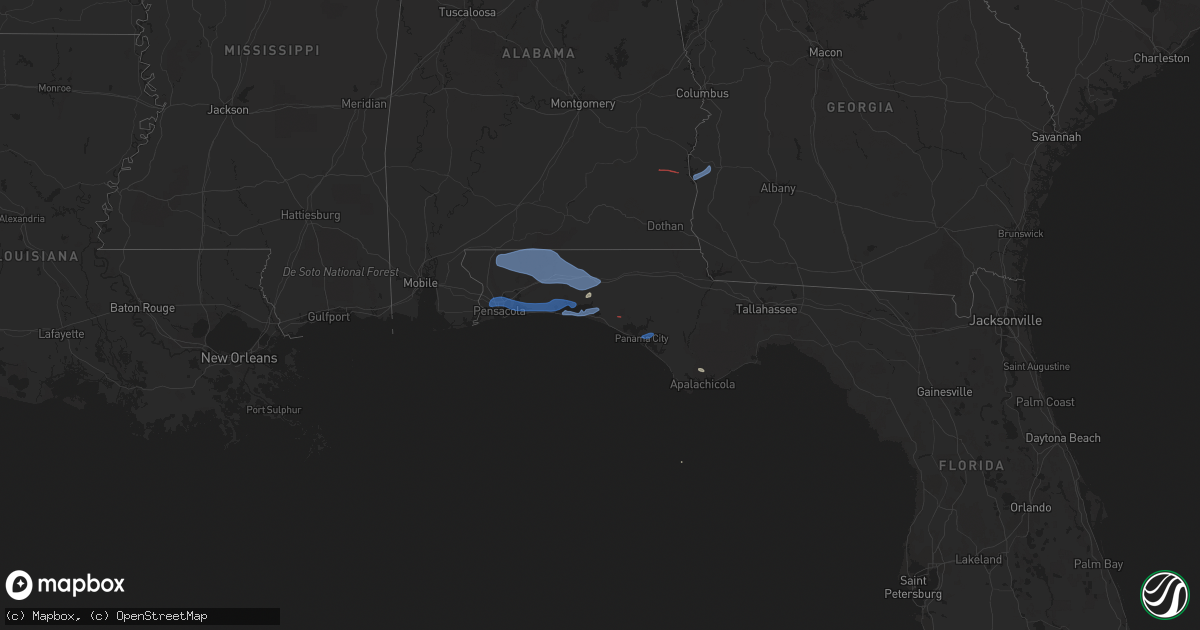
Hail Map on November 30, 2022
Get this storm
November 30 map
$229
one time, instant access
Download today. No call, no setup
Keep the $229
Bought the map and want the full workflow? Apply the entire $229 to a subscription within 7 days. None of it is wasted.
Every map, not just this one
This buys you this map. Subscription and you get every map we run, in the markets you choose from a few cities to whole states to nationwide. Plus real-time alerts the moment a storm fires.
Contact data
Name, contact info, occupancy, even credit band for addresses in the footprint. You go from where it hit to who to call.
Become the source they trust
Unlimited branding weather history reports on demand. You already have the documented answer ready for the property owner, and you are the one who showed up with it.
Property data and RoofTrace estimates
Pull up any address you have got, its value and the exact code rules for that jurisdiction, straight from One Click Code. Then RoofTrace estimates the squares, pitch, and roof value, priced the way you price.
Storm reports
New Hampshire
| Date | Description |
|---|---|
| 11/30/20225:42 PM CST | Social media photo showing large tree knocked down on liberty mill rd. Time estimated by radar. |
| 11/30/20225:30 PM CST | Social media report of large branches and two small trees knocked down during storm. Damage reported on davis village rd south of nh hwy 123. |
| 11/30/20225:24 PM CST | Trees and wires down on mccurdy rd. |
| 11/30/20221:07 AM CST | At 706 PM EST, a line of severe storms was located near Effingham, or 7 miles east of Ossipee, moving northeast at 50 mph. HAZARD...60 mph wind gusts. SOURCE...Radar indicated. IMPACT...Expect damage to roofs, siding, and trees. Locations impacted include... Portland, Lewiston, South Portland, Brunswick, Westbrook, Conway, Bridgton, Fryeburg, Mechanic Falls, Alfred, Ossipee, Naples, Topsham, Turner, Cumberland, Gorham, Falmouth, Buxton, Freeport and Gray.This includes the following highways... Interstate 295 between mile markers 4 and 29. Interstate 95 between mile markers 45 and 88. |
| 11/30/202212:20 AM CST | At 619 PM EST, a severe thunderstorm was located over New Ipswich, or 10 miles east of Jaffrey, moving northeast at 40 mph. HAZARD...60 mph wind gusts and penny size hail. SOURCE...Radar indicated. IMPACT...Expect damage to roofs, siding, and trees. Locations impacted include... Manchester, Nashua, Derry, Jaffrey, Merrimack, Bedford, Milford, Hooksett, Amherst, Litchfield, Hollis, Peterborough, New Boston, Mont Vernon, Lyndeborough, Rindge, Raymond, Sharon, New Ipswich and Goffstown.This includes the following highways... Interstate 293 between mile markers 1 and 11. Interstate 93 between mile markers 11 and 28. |
| 11/29/20226:09 PM CST | Observed trees down on huntress bridge rd north of effingham. Time estimated by radar. |
| 11/29/20226:09 PM CST | Delayed report: trees and wires down. Time estimated by radar. |
| 11/29/20226:05 PM CST | Delayed report: tree and wires down. Time estimated by radar. |
Washington
| Date | Description |
|---|---|
| 11/29/202211:03 PM CST | Report from mping: 1-inch tree limbs broken; shingles blown off. |
Alabama
| Date | Description |
|---|---|
| 11/30/20224:21 PM CST | A few trees were blown down between bexar and hackleburg in the northwest par tof marion county. |
| 11/30/20227:00 AM CST | Some roof damage reported to a carport in slocomb. |
| 11/30/20226:45 AM CST | Tree down in wicksburg. |
| 11/30/20226:42 AM CST | Brief ef1 tornado confirmed by storm survey. |
| 11/30/20226:32 AM CST | At 1232 AM CST, a severe thunderstorm was located near Smith Dam, or 13 miles north of Sumiton, moving east at 45 mph. HAZARD...60 mph wind gusts and quarter size hail. SOURCE...Radar indicated. IMPACT...Hail damage to vehicles is expected. Expect wind damage to roofs, siding, and trees. Locations impacted include... Hanceville, Good Hope, Dodge City, Garden City, Colony, Wilburn, Bremen, Arkadelphia, Black Bottom and Smith Lake. |
| 11/30/20226:30 AM CST | Trees down on a house in eufaula on monroe street via social media. |
| 11/30/20226:27 AM CST | At 1226 AM CST, severe thunderstorms were located along a line extending from near Smith Dam to near Binion Creek Landing, moving east at 55 mph. HAZARD...60 mph wind gusts. SOURCE...Radar indicated. IMPACT...Expect damage to roofs, siding, and trees. Locations impacted include... Birmingham, Hoover, Vestavia Hills, Bessemer, Homewood, Mountain Brook, Trussville, Hueytown, Gardendale, Irondale, Leeds, Moody, Fairfield, Fultondale, Oneonta, Cleveland, Dallas, Center Point, Pleasant Grove and Clay. |
| 11/30/20226:25 AM CST | Tree down on county road 72 near chancellor. |
| 11/30/20226:20 AM CST | At 1219 AM CST, severe thunderstorms were located along a line extending from near Ardmore to near Madison to near Decatur, moving east at 50 mph. HAZARD...60 mph wind gusts and penny size hail. SOURCE...Radar indicated. IMPACT...Expect damage to roofs, siding, and trees. Locations impacted include... Huntsville, Decatur, Madison, Athens, Moores Mill, Redstone Arsenal, Meridianville, Hazel Green, Priceville and Trinity. |
| 11/30/20226:15 AM CST | 4 chicken houses damaged near bakerhill near bud gary rd and alabama hwy 131. Tds on radar. |
| 11/30/20226:06 AM CST | Tree down at 684 east county road 36 blocking both lanes. |
| 11/30/20226:00 AM CST | Tree down blocking one lane of traffic at 1900 deese road in ozark. |
| 11/30/20226:00 AM CST | Tree down on highway 189 between elba and kinston. |
| 11/30/20221:22 AM CST | At 722 AM EST, severe thunderstorms were located along a line extending from near Lakepoint Resort State Park to 7 miles east of Richards Crossroads to near Abbeville, moving east at 40 mph. HAZARD...60 mph wind gusts. SOURCE...Radar indicated. IMPACT...Expect damage to roofs, siding, and trees. Locations impacted include... Fort Gaines, Morgan, Georgetown, Cuthbert, Dawson, Edison, Shellman, Parrott, Bellville, Bluffton, Wire Bridge, Parksville, Carnegie, Watson Crossroads, Ricks Place, Pecan, Chambliss, Hatcher, Morris and Bethel. |
| 11/30/202212:46 AM CST | At 646 AM CST, severe thunderstorms were located along a line extending from 11 miles east of Florala to near Crestview to 13 miles northwest of Wright to near Navarre Beach to near Oriole Beach, moving east at 45 mph. HAZARD...60 mph wind gusts. SOURCE...Radar indicated. IMPACT...Expect damage to roofs, siding, and trees. Locations impacted include... Santa Rosa Beach, De Funiak Springs, Bonifay, Eglin Air Force Base, Union, Liberty, Live Oak, Freeport, Paxton, Ponce De Leon, Caryville, Esto, Westville, Noma, Black, Oakwood Hills, Cluster Springs, Whitehead Crossroads, Villa Tasso and Cerrogordo. |
| 11/29/202211:38 PM CST | At 537 AM CST, severe thunderstorms were located along a line extending from 3 miles east of Loxley to near Silverhill to Fairhope to 7 miles west of Point Clear, moving east at 55 mph. HAZARD...60 mph wind gusts. SOURCE...Radar indicated. IMPACT...Expect damage to roofs, siding, and trees. Locations impacted include... Pensacola, Ferry Pass, Brent, West Pensacola, Ensley, Daphne, Warrington, Fairhope, Gulf Shores, Foley, Gulf Breeze, Orange Beach, Goulding, Robertsdale, Point Clear, Lillian, Myrtle Grove, Magnolia Springs, Bon Secour and Summerdale. |
| 11/29/202211:10 PM CST | At 510 AM CST, severe thunderstorms were located along a line extending from near Petrey to Brantley, moving east at 55 mph. HAZARD...60 mph wind gusts. SOURCE...Radar indicated. IMPACT...Expect damage to roofs, siding, and trees. Locations impacted include... Troy, Brundidge, Goshen, Banks, Antioch, Troy University, Tennille, Hamilton Crossroads, Monticello, Springhill, Tarentum, Brundidge Municipal Airport, Mossy Grove and Henderson. |
| 11/29/202211:02 PM CST | At 502 AM CST, severe thunderstorms were located along a line extending from near Petrey to 6 miles north of Dozier to 9 miles west of Red Level, moving east at 50 mph. HAZARD...70 mph wind gusts and penny size hail. SOURCE...Radar indicated. IMPACT...Expect considerable tree damage. Damage is likely to mobile homes, roofs, and outbuildings. Locations impacted include... Daleville, Elba, Enterprise, Fort Rucker, Ozark, Midland City, Level Plains, Newton, New Brockton, Ariton, Pinckard, Lee, Kinston, Mixons Crossroads, Hunt Field, Waterford, Curtis, Carl Folsom A/p, Hooper Stage Field and Gerald. |
| 11/29/202210:43 PM CST | At 443 AM CST, a severe thunderstorm was located over Wade, or 10 miles north of Escatawpa, moving east at 45 mph. HAZARD...60 mph wind gusts. SOURCE...Radar indicated. IMPACT...Expect damage to roofs, siding, and trees. Locations impacted include... Escatawpa, Hurley, Big Point, Vancleave, Wade and Latimer. |
| 11/29/202210:37 PM CST | At 436 AM CST, severe thunderstorms were located along a line extending from 5 miles southwest of Greenville to 3 miles northeast of Castleberry to 12 miles northwest of Poarch Creek Reservation, moving east at 55 mph. HAZARD...60 mph wind gusts. SOURCE...Radar indicated. IMPACT...Expect damage to roofs, siding, and trees. Locations impacted include... Andalusia, Greenville, Opp, Evergreen, Luverne, Frisco City, McCullough, Georgiana, Uriah, Brantley, McKenzie, River Falls, Castleberry, Excel, Red Level, Rutledge, Dozier, Repton, Heath and Gantt. |
| 11/29/20229:58 PM CST | At 357 AM CST, severe thunderstorms were located along a line extending from 6 miles west of Wagarville to 4 miles south of Deer Park, moving east at 40 mph. HAZARD...60 mph wind gusts. SOURCE...Radar indicated. IMPACT...Expect damage to roofs, siding, and trees. Locations impacted include... Frisco City, McCullough, Wagarville, Uriah, Calvert, Excel, McIntosh, I65 And AL 21 and Poarch Creek Reservation. |
| 11/29/20229:40 PM CST | At 340 AM CST, severe thunderstorms were located along a line extending from 11 miles northwest of Monroeville to 14 miles east of McIntosh, moving east at 45 mph. HAZARD...60 mph wind gusts and quarter size hail. SOURCE...Radar indicated. IMPACT...Hail damage to vehicles is expected. Expect wind damage to roofs, siding, and trees. Locations impacted include... Monroeville, Evergreen, Frisco City, Peterman, Georgiana, Uriah, McKenzie, Castleberry, Excel, Beatrice, Repton and I65 And US 84. |
| 11/29/20229:18 PM CST | At 318 AM CST, severe thunderstorms were located along a line extending from 6 miles northeast of Jackson to 5 miles northeast of McIntosh, moving east at 50 mph. HAZARD...60 mph wind gusts and quarter size hail. SOURCE...Radar indicated. IMPACT...Hail damage to vehicles is expected. Expect wind damage to roofs, siding, and trees. Locations impacted include... Monroeville, Jackson, Frisco City, Peterman, Leroy, Uriah, Excel and Repton. |
| 11/29/20227:48 PM CST | At 148 AM CST, a severe thunderstorm was located over Richton, moving east at 50 mph. HAZARD...60 mph wind gusts. SOURCE...Radar indicated. IMPACT...Expect damage to roofs, siding, and trees. Locations impacted include... Chatom, Tibbie, Millry, State Line, Buckatunna and Fruitdale. |
| 11/29/20227:34 PM CST | At 134 AM CST, severe thunderstorms were located along a line extending from near Ohatchee to near Lincoln to near Vincent, moving east at 35 mph. HAZARD...60 mph wind gusts. SOURCE...Radar indicated. IMPACT...Expect damage to roofs, siding, and trees. Locations impacted include... Anniston, Oxford, Talladega, Jacksonville, Cobb Town, West End-Cobb Town, Fort McClellan, Saks, Lincoln, Weaver, Riverside, Munford, Ohatchee, Hobson City, Waldo, Alpine Bay Resort, Talladega Superspeedway, Anniston Regional Airport, Blue Mountain and Alexandria. |
| 11/29/20227:25 PM CST | At 125 AM CST, a severe thunderstorm was located 4 miles northwest of Magnolia, or 9 miles southeast of Linden, moving northeast at 50 mph. HAZARD...60 mph wind gusts. SOURCE...Radar indicated. IMPACT...Expect damage to roofs, siding, and trees. This severe thunderstorm will remain over mainly rural areas of northwestern Wilcox County. |
| 11/29/20227:10 PM CST | At 110 AM CST, severe thunderstorms were located along a line extending from near Oneonta to Bluff Park, moving east at 60 mph. HAZARD...60 mph wind gusts. SOURCE...Radar indicated. IMPACT...Expect damage to roofs, siding, and trees. Locations impacted include... Hoover, Pell City, Leeds, Moody, Rainbow City, Springville, Odenville, Margaret, Argo, Ashville, Riverside, Vincent, Ragland, Ohatchee, Steele, Bald Rock, Vandiver, Harrisburg, Branchville and Greystone. |
Maine
| Date | Description |
|---|---|
| 11/29/20226:48 PM CST | Social media report showing tree down in intersection of larrabee and riverside. |
| 11/29/20226:48 PM CST | Utility pole down in the roadway. |
West Virginia
| Date | Description |
|---|---|
| 11/30/20226:00 AM CST | At 1159 AM EST, a strong line of showers were located along a line extending from near New Centerville to near Accident to near Bayard, moving east at 40 mph. HAZARD...60 mph wind gusts. SOURCE...Radar indicated. IMPACT...Damaging winds will cause some trees and large branches to fall. This could injure those outdoors, as well as damage homes and vehicles. Roadways may become blocked by downed trees. Localized power outages are possible. Unsecured light objects may become projectiles. Locations impacted include... Frostburg, Keyser, Mountain Lake Park, Oakland, Westernport, Bayard, Bittinger, Lonaconing, Piedmont, Grantsville, Loch Lynn Heights, Friendsville, Deer Park, Accident, Elk Garden, Kitzmiller, Eckhart Mines, Mount Savage, Barton and Midland. |
Mississippi
| Date | Description |
|---|---|
| 11/30/20226:28 AM CST | At 1227 AM CST, a severe thunderstorm was located over mainly rural areas of Amite County, moving east at 45 mph. HAZARD...Ping pong ball size hail and 60 mph wind gusts. SOURCE...Radar indicated. IMPACT...People and animals outdoors will be injured. Expect hail damage to roofs, siding, windows, and vehicles. Expect wind damage to roofs, siding, and trees. Locations impacted include... Mccomb, Liberty, Magnolia, Summit and Mccomb Airport. This includes Interstate 55 in Mississippi between mile markers 7 and24. |
| 11/30/20226:00 AM CST | At 1200 AM CST, severe thunderstorms were located along a line extending from near Glen Allen to near Ashcraft Corner to near Pickensville, moving east at 60 mph. HAZARD...60 mph wind gusts. SOURCE...Radar indicated. IMPACT...Expect damage to roofs, siding, and trees. Locations impacted include... Tuscaloosa, Northport, Jasper, Fayette, Sumiton, Cordova, Dora, Carbon Hill, Gordo, Reform, Carrollton, Pickensville, Holt, Brookwood, Berry, Parrish, Coker, Oakman, Glen Allen and Sipsey. |
| 11/30/20222:24 AM CST | Sheriffs office reported down trees across county. |
| 11/29/202210:47 PM CST | At 447 AM CST, severe thunderstorms were located along a line extending from 4 miles west of Wilmer to 4 miles north of Hurley to Wade to 3 miles northwest of Latimer, moving east at 65 mph. HAZARD...60 mph wind gusts. SOURCE...Radar indicated. IMPACT...Expect damage to roofs, siding, and trees. Locations impacted include... Midtown Mobile, Downtown Mobile, Prichard, Daphne, Tillmans Corner, Fairhope, Saraland, Bay Minette, Theodore, Chickasaw, Satsuma, Spanish Fort, Grand Bay, Point Clear, Stapleton, Semmes, Tanner Williams, I65 And I165, Mobile Regional Airport and Wilmer. |
| 11/29/202210:15 PM CST | At 415 AM CST, severe thunderstorms were located along a line extending from 8 miles west of Lucedale to 17 miles south of McLain to 18 miles east of Perkinston to 6 miles east of McHenry, moving east at 55 mph. HAZARD...60 mph wind gusts. SOURCE...Radar indicated. IMPACT...Expect damage to roofs, siding, and trees. Locations impacted include... Lucedale, Chunchula, McHenry, Gulfcrest, Semmes, Tanner Williams, Movico and Wilmer. |
| 11/29/20229:35 PM CST | At 333 AM CST, a severe thunderstorm was located 11 miles east of Poplarville, moving east at 55 mph. HAZARD...60 mph wind gusts and nickel size hail. SOURCE...Radar indicated. IMPACT...Expect damage to roofs, siding, and trees. Locations impacted include... Wiggins, Perkinston and McHenry. |
| 11/29/20229:08 PM CST | At 307 AM CST, a severe thunderstorm was located near Lumberton, or 16 miles northeast of Poplarville, moving east at 40 mph. HAZARD...60 mph wind gusts. SOURCE...Radar indicated. IMPACT...Expect damage to roofs, siding, and trees. This severe thunderstorm will be near... Rock Hill around 315 AM CST. Brooklyn, Mclaurin and Maxie around 325 AM CST. |
| 11/29/20229:04 PM CST | At 304 AM CST, severe thunderstorms were located along a line extending from 6 miles west of Chatom to 8 miles east of Richton to 3 miles north of Beaumont to 5 miles northeast of Brooklyn, moving east at 30 mph. HAZARD...60 mph wind gusts. SOURCE...Radar indicated. IMPACT...Expect damage to roofs, siding, and trees. Locations impacted include... Jackson, Chatom, Richton, Leakesville, Saint Stephens, Wagarville, Leroy, Deer Park, Tibbie, Beaumont, New Augusta, McLain, State Line, Buckatunna, Fruitdale and McIntosh. |
| 11/29/20228:53 PM CST | At 253 AM CST, a severe thunderstorm was located over Sun, or 8 miles southwest of Bogalusa, moving east at 45 mph. HAZARD...Ping pong ball size hail and 60 mph wind gusts. SOURCE...Radar indicated. IMPACT...People and animals outdoors will be injured. Expect hail damage to roofs, siding, windows, and vehicles. Expect wind damage to roofs, siding, and trees. Locations impacted include... Bogalusa, Poplarville, Sun, Crossroads and Mcneil. This includes Interstate 59 in Mississippi between mile markers 11and 31. |
| 11/29/20228:26 PM CST | At 225 AM CST, a severe thunderstorm was located over Oak Grove, or near West Hattiesburg, moving east at 40 mph. HAZARD...60 mph wind gusts. SOURCE...Radar indicated. IMPACT...Expect damage to roofs, siding, and trees. This severe thunderstorm will be near... Hattiesburg around 230 AM CST. Petal and Sunrise around 240 AM CST. Macedonia around 245 AM CST. |
| 11/29/20228:23 PM CST | At 222 AM CST, a severe thunderstorm was located 5 miles southwest of State Line, or 15 miles north of Leakesville, moving east at 50 mph. HAZARD...60 mph wind gusts and quarter size hail. SOURCE...Radar indicated. IMPACT...Hail damage to vehicles is expected. Expect wind damage to roofs, siding, and trees. Locations impacted include... Jackson, Chatom, Saint Stephens, Wagarville, Leroy, Tibbie, State Line and Fruitdale. |
| 11/29/20228:11 PM CST | At 211 AM CST, a severe thunderstorm was located near Dexter, or 12 miles northeast of Franklinton, moving east at 40 mph. HAZARD...60 mph wind gusts and quarter size hail. SOURCE...Radar indicated. IMPACT...Hail damage to vehicles is expected. Expect wind damage to roofs, siding, and trees. Locations impacted include... Varnado, Dexter and Angie. |
| 11/29/20228:02 PM CST | At 202 AM CST, a severe thunderstorm was located 4 miles east of Macedonia, or 8 miles west of Richton, moving east at 35 mph. HAZARD...60 mph wind gusts and quarter size hail. SOURCE...Radar indicated. IMPACT...Hail damage to vehicles is expected. Expect wind damage to roofs, siding, and trees. Locations impacted include... Richton. |
| 11/29/20227:26 PM CST | At 126 AM CST, a severe thunderstorm was located near Salem, or near Kokomo, moving east at 50 mph. HAZARD...60 mph wind gusts and quarter size hail. SOURCE...Radar indicated. IMPACT...Hail damage to vehicles is expected. Expect wind damage to roofs, siding, and trees. This severe thunderstorm will be near... Kokomo around 130 AM CST. Holly Springs around 135 AM CST. Columbia, Morgantown and Goss around 140 AM CST. Improve around 155 AM CST. |
| 11/29/20227:20 PM CST | At 119 AM CST, a severe thunderstorm was located over Hattiesburg, moving east at 40 mph. HAZARD...60 mph wind gusts and quarter size hail. SOURCE...Radar indicated. IMPACT...Hail damage to vehicles is expected. Expect wind damage to roofs, siding, and trees. Locations impacted include... Richton. |
| 11/29/20227:10 PM CST | At 109 AM CST, a severe thunderstorm was located over Oak Grove, or near West Hattiesburg, moving east at 50 mph. HAZARD...60 mph wind gusts and quarter size hail. SOURCE...Radar indicated. IMPACT...Hail damage to vehicles is expected. Expect wind damage to roofs, siding, and trees. This severe thunderstorm will be near... Hattiesburg, West Hattiesburg and Rawls Springs around 115 AM CST. Petal and Sunrise around 125 AM CST. Macedonia around 130 AM CST. |
Florida
| Date | Description |
|---|---|
| 11/30/202212:16 PM CST | Trees and tree debris damaged utility equipment along plummer grant road per the jax electric authory. The time of damage was based on radar. |
| 11/30/202212:16 PM CST | Trees an |
| 11/30/202212:10 PM CST | Delayed report. Tree roughly 14 inches in diameter snapped... Football training metal equipment moved by wind. |
| 11/30/202212:00 PM CST | Trees and tree debris damaged utility equipment near lyle road. Wind gusts measured in the area were 35-45 mph around the time of damage. The time was based on radar. R |
| 11/30/202211:00 AM CST | Duke energy utility company reported damage to utility equipment from trees and debris blown down onto powerlines. The time of damage was based on radar. |
| 11/30/20229:31 AM CST | Florida highway patrol reports tree down near intersection of bloxham cutoff road and wakulla springs road. |
| 11/30/20228:39 AM CST | Personal weather station gusted to 60 mph. |
| 11/30/20228:28 AM CST | Tree caused a power outage to 151 customers near gretna via talquin electric outage map. |
| 11/30/20227:50 AM CST | Trees down in the central part of washington county. |
| 11/30/20227:50 AM CST | Trees down in the central part of |
| 11/30/20227:42 AM CST | Public reported that personal weather station measured a 61 mph gust on bay grove road. |
| 11/30/20227:26 AM CST | Trees down in the northwest part of washington county. |
| 11/30/20227:15 AM CST | Emergency manager reports a tree down on a house... Resulting in structural damage. |
| 11/30/20227:15 AM CST | Trees down along highway 177. |
| 11/30/20227:13 AM CST | Trees down near spradlin road and highway 83. |
| 11/30/20227:10 AM CST | Trees down along highway 177. |
| 11/30/20226:54 AM CST | Emergency manager reports a tree down on a house... Resulting in structural damage. |
| 11/30/20226:27 AM CST | Emergency manager reports a tree and powerlines down on munson highway. |
| 11/30/20226:09 AM CST | Escambia county |
| 11/30/20225:36 AM CST | At 1136 AM EST, strong to severe thunderstorms were located near Live Oak, moving southeast at 35 mph. HAZARD...60 mph wind gusts. SOURCE...Radar indicated. IMPACT...Expect damage to roofs, siding, and trees. Locations impacted include... Lake City, Live Oak, White Springs, Suwannee Springs, Wellborn, Five Points, Winfield, Suwannee Valley, Mcalpin and Luraville. |
| 11/30/20225:05 AM CST | At 1105 AM EST, severe thunderstorms were located along a line extending from 10 miles north of Eastpoint to near Apalachicola to 9 miles west of St George Island, moving east at 35 mph. HAZARD...60 mph wind gusts and quarter size hail. SOURCE...Radar indicated. IMPACT...Hail damage to vehicles is expected. Expect wind damage to roofs, siding, and trees. Locations impacted include... Carrabelle, St George Island, Eastpoint, Apalachicola, Franklin, Carrabelle Beach, Buck Siding, Turkey Point, Royal Bluff, High Bluff, Yent Place, St George Island St Pk, Beverly, Green Point, Bay City, Lanark Village, Apalachicola Airport, Creels, Hays Place and Fort Gadsden. |
| 11/30/20224:52 AM CST | At 1051 AM EST, severe thunderstorms were located along a line extending from near Moody Air Force Base to 7 miles southwest of Lake Park, moving southeast at 40 mph. HAZARD...60 mph wind gusts. SOURCE...Radar indicated. IMPACT...Expect damage to roofs, siding, and trees. Locations impacted include... Jasper, Jennings, Statenville, Mayday, Needmore, Blue Springs and Crossroads. |
| 11/30/20223:31 AM CST | At 931 AM EST, severe thunderstorms were located along a line extending from near Riverside to near Coolidge to 8 miles southwest of Whigham, moving east at 35 mph. HAZARD...60 mph wind gusts. SOURCE...Radar indicated. IMPACT...Expect damage to roofs, siding, and trees. Locations impacted include... Nashville, Moultrie, Adel, Thomasville, Lakeland, Valdosta, Lake Park, Cairo, Quitman, Hahira, Sparks, Boston, Ray City, Ochlocknee, Pavo, Coolidge, Riverside, I-75 At Exit 16, Moody Air Force Base and Schley. |
| 11/30/20223:21 AM CST | At 921 AM EST/821 AM CST/, severe thunderstorms were located along a line extending from 9 miles east of Chattahoochee to near Greensboro to 16 miles west of Blountstown to 6 miles north of Lynn Haven to 8 miles southwest of Panama City Beach, moving southeast at 30 mph. HAZARD...60 mph wind gusts. SOURCE...Radar indicated. IMPACT...Expect damage to roofs, siding, and trees. Locations impacted include... Quincy, Tallahassee, Havana, St. Marks, Midway, Woodville, Crawfordville, Port St. Joe, Blountstown, Mexico Beach, Florida State University, Stonemill Creek, Tallahassee Comm College, Doak Campbell Stadium, Chattahoochee, Greensboro, Florida A And M, Orange, Wakulla and Wewahitchka. |
| 11/30/20222:22 AM CST | At 822 AM EST/722 AM CST/, severe thunderstorms were located along a line extending from near Chipley to 14 miles northwest of Vernon to 9 miles southeast of De Funiak Springs to near Eglin Air Force Base to near Destin, moving east at 45 mph. HAZARD...70 mph wind gusts. SOURCE...Radar indicated. IMPACT...Expect considerable tree damage. Damage is likely to mobile homes, roofs, and outbuildings. Locations impacted include... Panama City, Lynn Haven, Panama City Beach, Callaway, Vernon, Blountstown, Springfield, Mexico Beach, Hiland Park, Tyndall Air Force Base, Wewahitchka, Bradford, Parker, Altha, Wausau, Ebro, Clarksville, Allanton, Gulf Resort Beach and West Panama City. |
| 11/30/20221:13 AM CST | At 713 AM CST, severe thunderstorms were located along a line extending from 5 miles north of Niceville to 3 miles northwest of Valparaiso to near Eglin AFB to Cinco Bayou, moving east at 40 mph. HAZARD...60 mph wind gusts. SOURCE...Radar indicated. IMPACT...Expect damage to roofs, siding, and trees. Locations impacted include... Fort Walton Beach, Niceville, Destin, Eglin AFB, Valparaiso, Lake Lorraine, Shalimar and Cinco Bayou. |
| 11/30/20221:01 AM CST | At 701 AM CST, severe thunderstorms were located along a line extending from 8 miles northwest of De Funiak Springs to 7 miles east of Crestview to 9 miles north of Niceville to 8 miles north of Wright, moving east at 60 mph. HAZARD...70 mph wind gusts. SOURCE...Radar indicated. IMPACT...Expect considerable tree damage. Damage is likely to mobile homes, roofs, and outbuildings. Locations impacted include... Crestview. |
| 11/30/202212:58 AM CST | At 657 AM CST, severe thunderstorms were located along a line extending from near Webb to Cowarts to near Taylor to near Geneva, moving southeast at 30 mph. HAZARD...60 mph wind gusts. SOURCE...Radar indicated. IMPACT...Expect damage to roofs, siding, and trees. Locations impacted include... Headland, Dothan, Geneva, Hartford, Taylor, Kinsey, Ashford, Slocomb, Samson, Cowarts, Webb, Malvern, Rehobeth, Avon, Esto, Black, Haleburg, Memphis, Kellys Crossroads and Wilson Mill. |
| 11/30/202212:32 AM CST | At 631 AM CST, severe thunderstorms were located along a line extending from 3 miles northeast of Bagdad to 7 miles southeast of Pea Ridge to 3 miles east of Pensacola to Warrington, moving east at 45 mph. HAZARD...60 mph wind gusts. SOURCE...Radar indicated. IMPACT...Expect damage to roofs, siding, and trees. Locations impacted include... Pensacola, Ferry Pass, Brent, West Pensacola, Wright, Fort Walton Beach, Warrington, Niceville, Destin, Eglin AFB, Milton, Valparaiso, Gulf Breeze, Goulding, Mary Esther, Bagdad, Ocean City, Lake Lorraine, Myrtle Grove and Oriole Beach. |
| 11/30/202212:08 AM CST | At 607 AM CST, severe thunderstorms were located along a line extending from 4 miles southwest of Riverview to 8 miles southeast of Jay to 8 miles east of Molino to near Gonzalez, moving east at 65 mph. HAZARD...70 mph wind gusts. SOURCE...Radar indicated. IMPACT...Expect considerable tree damage. Damage is likely to mobile homes, roofs, and outbuildings. Locations impacted include... Crestview, Pace, Milton, Bagdad, Baker, Laurel Hill, Pea Ridge, Roeville, Floridatown and Point Baker. |
| 11/29/202211:56 PM CST | At 555 AM CST, severe thunderstorms were located along a line extending from near Doster to near Ozark to near Fort Rucker to Opp, moving southeast at 30 mph. HAZARD...60 mph wind gusts. SOURCE...Radar indicated. IMPACT...Expect damage to roofs, siding, and trees. Locations impacted include... Daleville, Elba, Geneva, Enterprise, Headland, Dothan, Fort Rucker, Ozark, Hartford, Taylor, Midland City, Kinsey, Ashford, Level Plains, Slocomb, Samson, Cowarts, Newton, Webb and New Brockton. |
| 11/29/202211:26 PM CST | At 525 AM CST, severe thunderstorms were located along a line extending from near I65 And AL 225 to 3 miles north of Stapleton to Spanish Fort to 7 miles southeast of I10 And I65, moving east at 65 mph. HAZARD...70 mph wind gusts. SOURCE...Radar indicated. IMPACT...Expect considerable tree damage. Damage is likely to mobile homes, roofs, and outbuildings. Locations impacted include... Daphne, Gonzalez, Bay Minette, Atmore, Pace, Spanish Fort, Century, Flomaton, Loxley, Stockton, Stapleton, Molino, Jay, Pollard, Riverview, Bratt, Point Baker and I65 And AL 225. |
| 11/29/20227:06 PM CST | At 105 PM EST, a severe thunderstorm was located over Nas Jax, or near Orange Park, moving east at 30 mph. HAZARD...60 mph wind gusts. SOURCE...Radar indicated. IMPACT...Expect damage to roofs, siding, and trees. Locations impacted include... Orange Park, Unf, Mandarin, Fruit Cove, Ponte Vedra Beach, Jacksonville Beach, Sawgrass, Baymeadows, Nocatee and Ortega. |
Georgia
| Date | Description |
|---|---|
| 11/30/20228:53 AM CST | A couple of trees were blown down in colquitt county. |
| 11/30/20228:53 AM CST | Tree down on highway 319 near mile marker 5. |
| 11/30/20228:50 AM CST | Tree down along the 3000 block of lower cairo road. |
| 11/30/20228:38 AM CST | Video of a brief tornado in a field with no damage. |
| 11/30/20228:26 AM CST | Tree down on mooty bridge rd. Near concord dr. |
| 11/30/20228:26 AM CST | Damage to a barn. |
| 11/30/20227:45 AM CST | Tree down on jericho road. |
| 11/30/20227:29 AM CST | Tree down on jeterville road. |
| 11/30/20227:00 AM CST | Two trees were blown down in early county. |
| 11/30/20226:50 AM CST | Two trees were blown down in randolph county. |
| 11/30/20222:44 AM CST | At 844 AM EST/744 AM CST/, severe thunderstorms were located along a line extending from 10 miles southwest of Newton to 10 miles north of West Bainbridge to 6 miles southeast of Donalsonville to 17 miles northwest of Chattahoochee to near Marianna to 8 miles east of Chipley, moving southeast at 40 mph. HAZARD...60 mph wind gusts. SOURCE...Radar indicated. IMPACT...Expect damage to roofs, siding, and trees. Locations impacted include... Newton, Pelham, Marianna, Chipley, Bainbridge, Donalsonville, Cairo, Camilla, Baconton, Whigham, West Bainbridge, Chattahoochee, Sneads, Cottondale, Grand Ridge, Greenwood, Alford, Attapulgus, Sale City and Iron City. |
| 11/30/20221:45 AM CST | At 745 AM EST/645 AM CST/, severe thunderstorms were located along a line extending from 8 miles southeast of Fort Gaines to Columbia to near Slocomb to 8 miles south of Geneva, moving southeast at 40 mph. HAZARD...60 mph wind gusts. SOURCE...Radar indicated. IMPACT...Expect damage to roofs, siding, and trees. Locations impacted include... Colquitt, Cottonwood, Blakely, Marianna, Chipley, Graceville, Donalsonville, Bainbridge, Ashford, Arlington, Columbia, Chattahoochee, Douglasville, Centerville, Malone, Sneads, Cottondale, Grand Ridge, Greenwood and Avon. |
| 11/30/202212:09 AM CST | At 608 AM CST, severe thunderstorms were located along a line extending from near Texasville to 10 miles south of Blue Springs State Park, moving east at 45 mph. HAZARD...60 mph wind gusts. SOURCE...Radar indicated. IMPACT...Expect damage to roofs, siding, and trees. Locations impacted include... Abbeville, Shorterville, Walter F. George Lock And Dam, Barnes, Edwin, Hardwickburg, Otho, Hayes, Scottsboro Crossroads, Double Bridges, Murphy Station, Graball, Screamer, Coates, Thomas Mill Creek, Lawrenceville, Abbeville Municipal A/P and Willis Crossroads. |
| 11/29/202211:52 PM CST | At 552 AM CST, severe thunderstorms were located along a line extending from near Boot Hill to Doster, moving east at 50 mph. HAZARD...60 mph wind gusts. SOURCE...Radar indicated. IMPACT...Expect damage to roofs, siding, and trees. Locations impacted include... Eufaula, Clio, Clayton, Louisville, Blue Springs, Tyler Crossroads, Doster, Gaino, Blue Springs State Park, Osco, Texasville, Richards Crossroads, White Oak, Boot Hill, Millers Ford, Clayton Municipal Airport and Baker Hill. |
| 11/29/20229:28 PM CST | At 328 AM EST, severe thunderstorms were located along a line extending from near Buchanan to Mount Zion to near Graham, moving east at 65 mph. HAZARD...60 mph wind gusts. SOURCE...Radar indicated. IMPACT...Expect damage to roofs, siding, and trees. Locations impacted include... Newnan, Douglasville, Carrollton, City of South Fulton, Villa Rica, Fairburn, Bremen, Palmetto, Temple, Bowdon, Mount Zion, Whitesburg, Waco, Ephesus, Centralhatchee, Roopville, Lithia Springs, Chattahoochee Hills, East Newnan and Plant Yates. |
| 11/29/20227:56 PM CST | At 156 AM CST, severe thunderstorms were located along a line extending from Jacksonville State University to near Oxford Lake to near Waldo, moving east at 60 mph. HAZARD...60 mph wind gusts. SOURCE...Radar indicated. IMPACT...Expect damage to roofs, siding, and trees. Locations impacted include... Heflin, Ranburne, Fruithurst, Edwardsville, Woodland, Morrison Cross Roads, Barfield, Corinth, Muscadine, Abernathy, Fosters Cross Roads, Delta, Mars Hills, Mount Cheaha, Graham, Newell, Coleman Lake And Campground, Trickem, Lake Cleburne and Liberty Hill. |
Louisiana
| Date | Description |
|---|---|
| 11/29/20228:30 PM CST | At 229 AM CST, a severe thunderstorm was located over Sandy Hook, moving east at 40 mph. HAZARD...60 mph wind gusts and half dollar size hail. SOURCE...Radar indicated. IMPACT...Hail damage to vehicles is expected. Expect wind damage to roofs, siding, and trees. This severe thunderstorm will be near... Pinebur around 240 AM CST. Baxterville around 250 AM CST. Purvis and Pine Ridge around 305 AM CST. |
Maryland
| Date | Description |
|---|---|
| 11/30/202211:02 AM CST | A local report indicates 60 MPH wind near 5 W GRANTSVILLE |
| 11/29/20227:15 PM CST | At 115 PM EST, severe thunderstorms were located along a line extending from 7 miles southeast of Berkeley Springs to near Star Tannery to near Mathias, moving east at 45 mph. HAZARD...60 mph wind gusts. SOURCE...Radar indicated. IMPACT...Damaging winds will cause some trees and large branches to fall. This could injure those outdoors, as well as damage homes and vehicles. Roadways may become blocked by downed trees. Localized power outages are possible. Unsecured light objects may become projectiles. Locations impacted include... Hagerstown, Winchester, Martinsburg, Strasburg, Woodstock, Millwood Pike, Fountainhead-Orchard Hills, Inwood, Paramount-Long Meadow, Wilson-Conococheague, Williamsport, Stephens City, Wardensville, Mathias, Star Tannery, Long Meadow, Basye-Bryce Mountain, Saint James, Berkeley and Halfway. |
Cities Impacted by Hail Map on November 30, 2022
- Defuniak Springs, FL
- Eastpoint, FL
- Shalimar, FL
- Milton, FL
- Pensacola, FL
- Fort Walton Beach, FL
- Niceville, FL
- Hurlburt Field, FL
- Valparaiso, FL
- Mary Esther, FL
- Eglin Afb, FL
- Gulf Breeze, FL
- Navarre, FL
- Wing, AL
- Crestview, FL
- Laurel Hill, FL
- Baker, FL
- Holt, FL
- Jay, FL
- Brewton, AL
- Destin, FL
- Santa Rosa Beach, FL
- Miramar Beach, FL
- Freeport, FL
- Panama City, FL
- Eufaula, AL
- Clayton, AL
- Fort Gaines, GA
- Coleman, GA
- Morris, GA
- Cuthbert, GA