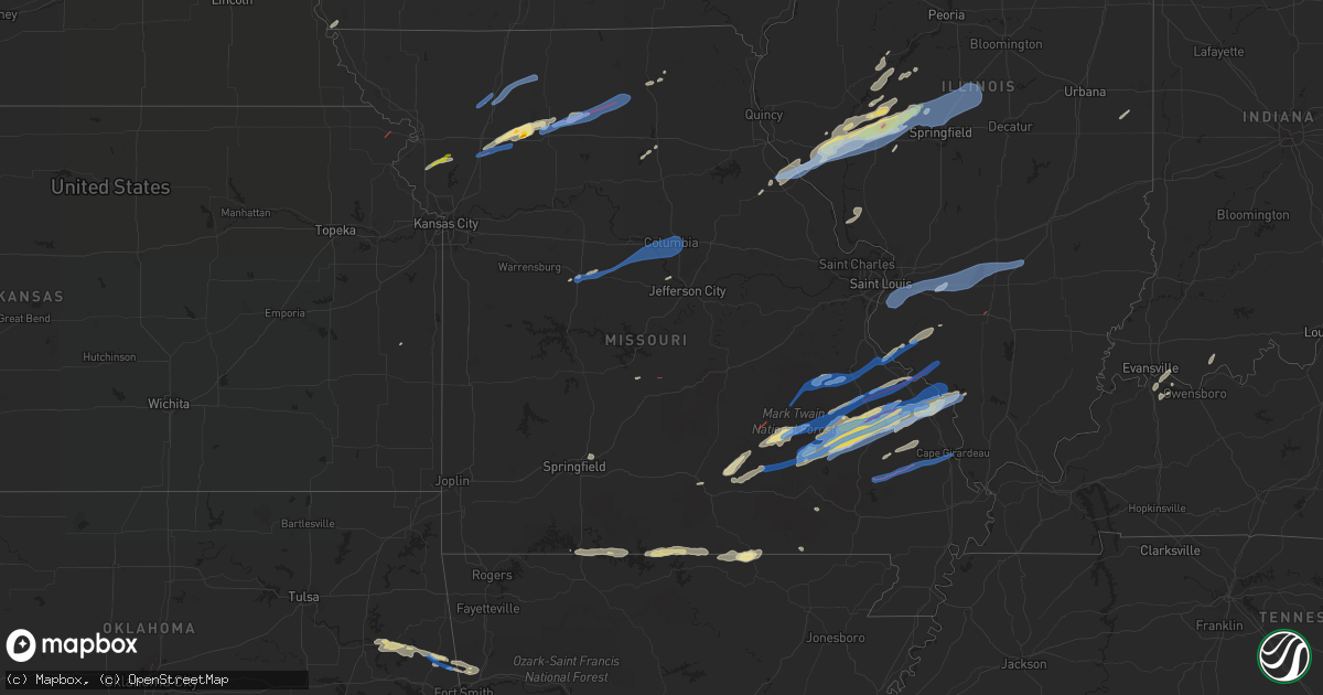
Hail Map in Missouri on October 24, 2021
Get this storm
October 24 map
$229
one time, instant access
Download today. No call, no setup
Keep the $229
Bought the map and want the full workflow? Apply the entire $229 to a subscription within 7 days. None of it is wasted.
Every map, not just this one
This buys you this map. Subscription and you get every map we run, in the markets you choose from a few cities to whole states to nationwide. Plus real-time alerts the moment a storm fires.
Contact data
Name, contact info, occupancy, even credit band for addresses in the footprint. You go from where it hit to who to call.
Become the source they trust
Unlimited branding weather history reports on demand. You already have the documented answer ready for the property owner, and you are the one who showed up with it.
Property data and RoofTrace estimates
Pull up any address you have got, its value and the exact code rules for that jurisdiction, straight from One Click Code. Then RoofTrace estimates the squares, pitch, and roof value, priced the way you price.
Storm reports in Missouri
Missouri
| Date | Description |
|---|---|
| 10/24/20216:53 PM CDT | An nws storm survey revealed that an ef-1 tornado with winds estimated at 90 mph occurred just northwest of richland... Mo. This tornado was on the ground for 4 minutes |
| 10/24/20216:53 PM CDT | Damage to one home... Multiple outbuildings and trees. |
| 10/24/20216:45 PM CDT | Trees over highway 94 and aa. |
| 10/24/20216:40 PM CDT | Extensive damage to a barn... A garage... And trees in the area. |
| 10/24/20216:38 PM CDT | Trees down over the roadway. |
| 10/24/20215:20 PM CDT | Tornado crossed hwy 129 near winigan mo... Per storm chaser located 2 miles north of new boston. |
| 10/24/20214:59 PM CDT | Brief circulation with debris just east of sedalia along hwy 50. |
| 10/24/20214:57 PM CDT | Nws storm survey found evidence of a brief ef-0 tornado just south of sedalia. |
| 10/24/20214:47 PM CDT | A local report indicates a tornado near 3 W LINNEUS |
| 10/24/20214:15 PM CDT | Nws storm survey found evidence of a brief ef-0 tornado about 6 miles nw of chillicothe. |
| 10/24/20214:08 PM CDT | Tree down in new london near the sheriffs office. |
| 10/24/20214:02 PM CDT | A local report indicates 1.50 inch wind near BRECKENRIDGE |
| 10/24/20213:50 PM CDT | Possible tornado...reports of trees uprooted. |
| 10/24/20213:36 PM CDT | Nws storm survey found evidence of a short lived ef-0 tornado just southwest of old pattonsburg. |
| 10/24/20213:30 PM CDT | Roof damaged wnw of mirable. |
| 10/24/20216:50 AM CDT | At 1150 PM CDT, severe thunderstorms were located along a line extending from near Maynard to 7 miles southwest of Ravenden, moving east at 40 mph. HAZARD...60 mph wind gusts and quarter size hail. SOURCE...Radar indicated. IMPACT...Hail damage to vehicles is expected. Expect wind damage to roofs, siding, and trees. Locations impacted include... Pocahontas... Walnut Ridge... Imboden... Ravenden... Reyno... College City... Maynard... Biggers... O'Kean... Annieville... Attica... Whiskerville... Giles Spur... Middlebrook... Ingram... Shannon... Birdell... Dicus... Elnora... Elkins Park... |
| 10/24/20216:37 AM CDT | At 1136 PM CDT, a severe thunderstorm was located over Dutchtown, or near Chaffee, moving east at 65 mph. HAZARD...60 mph wind gusts. SOURCE...Radar indicated. IMPACT...Expect damage to roofs, siding, and trees. This severe thunderstorm will be near... Scott City and Kelso around 1140 PM CDT. Cape Girardeau around 1145 PM CDT. Ware around 1155 PM CDT.Other locations in the path of this severe thunderstorm includeJonesboro.This includes Interstate 55 between Mile Markers 82 and 103. |
| 10/24/20215:31 AM CDT | At 1030 PM CDT, a severe thunderstorm was located near Sturkie, or 10 miles northwest of Salem in Fulton County, moving east at 35 mph. This storm has a history of producing winds of 60 to 70 mph! HAZARD...60 mph wind gusts and quarter size hail. SOURCE...Radar indicated. IMPACT...Hail damage to vehicles is expected. Expect wind damage to roofs, siding, and trees. Locations impacted include... Mammoth Spring... Mammoth Spring State Park... Dalton... Armstrong... Moko... Fryatt... Elm Store... Saddler Falls... Eleven Point... Camp... Wirth... Saddle... |
| 10/24/20215:07 AM CDT | At 1007 PM CDT, a severe thunderstorm was located near Ellington, moving east at 50 mph. HAZARD...60 mph wind gusts. SOURCE...Radar indicated. IMPACT...Expect damage to roofs, siding, and trees. This severe thunderstorm will be near... Ellington around 1015 PM CDT.Other locations in the path of this severe thunderstorm includeAnnapolis.This also includes Clearwater Lake Recreational Area. |
| 10/24/20214:42 AM CDT | At 941 PM CDT, a severe thunderstorm was located 9 miles northeast of Perryville, moving east at 50 mph. HAZARD...60 mph wind gusts and penny size hail. SOURCE...Radar indicated. IMPACT...Expect damage to roofs, siding, and trees. This severe thunderstorm will be near... Ava around 1000 PM CDT.Other locations in the path of this severe thunderstorm includeMurphysboro, De Soto, Elkville and Hurst.This includes Interstate 55 between Mile Markers 123 and 125. |
| 10/24/20214:37 AM CDT | At 937 PM CDT, severe thunderstorms were located along a line extending from 12 miles northeast of Summersville to near Birch Tree to 6 miles south of Mountain View, moving east at 55 mph. HAZARD...60 mph wind gusts. SOURCE...Radar indicated. IMPACT...Expect damage to roofs, siding, and trees. Locations impacted include... Echo Bluff State Park... Current River State Park... Ozark National Scenic Riverways... Winona... Birch Tree... Eminence... Alley Spring... Midridge... Round Spring... West Eminence... |
| 10/24/20214:37 AM CDT | At 937 PM CDT, a severe thunderstorm was located near Oates, moving northeast at 60 mph. HAZARD...60 mph wind gusts. SOURCE...Radar indicated. IMPACT...Expect damage to roofs, siding, and trees. This severe thunderstorm will be near... Belleview and Glover around 955 PM CDT.Other locations in the path of this severe thunderstorm includeIronton, Pilot Knob and Arcadia.This also includes Johnsons Shut-Ins State Park, Fort DavidsonHistoric Site, Elephant Rocks State Park, and Taum Sauk MountainState Park. |
| 10/24/20214:18 AM CDT | At 917 PM CDT, severe thunderstorms were located along a line extending from near Willow Springs to near Price Place, moving east at 40 mph. HAZARD...60 mph wind gusts. SOURCE...Radar indicated. IMPACT...Expect damage to roofs, siding, and trees. Locations impacted include... West Plains... Grand Gulf State Park... Mountain View... Willow Springs... Birch Tree... Pomona... Bakersfield... South Fork... Koshkonong... Brandsville... Montier... Thomasville... Peace Valley... Lanton... Teresita... Pottersville... Caulfield... Rover... Siloam Springs... White Church... |
| 10/24/20214:08 AM CDT | At 908 PM CDT, severe thunderstorms were located along a line extending from near Murphy to near Antonia to near Barnhart to near Horine, moving northeast at 55 mph. HAZARD...60 mph wind gusts. SOURCE...Radar indicated. IMPACT...Expect damage to roofs, siding, and trees. Severe thunderstorms will be near... Arnold around 915 PM CDT. Oakville, Mehlville, Lemay, Valmeyer, Fountain and Concord around 920 PM CDT. Columbia, Dupo and East Carondelet around 925 PM CDT.Other locations in the path of these severe thunderstorms includeCahokia, Waterloo, Millstadt, Cahokia Parks Airport, Alorton, EastSt. Louis, Centreville, Belleville, Fairview Heights, Swansea,Shiloh, Caseyville, Smithton, O'Fallon, Freeburg, Mascoutah, Lebanonand Scott AFB.This includes the following highways... Interstate 64 in Illinois between exits 12 and 27. Interstate 55 in Missouri between exits 180 and 191.This also includes Mastodon Historic Site, Sandy Creek Covered BridgeHistoric Site, and Gov. Dunklin's Grave Historic Site. |
| 10/24/20214:04 AM CDT | At 904 PM CDT, severe thunderstorms were located along a line extending from 7 miles south of Raymondville to near Willow Springs, moving east at 35 mph. HAZARD...60 mph wind gusts. SOURCE...Radar indicated. IMPACT...Expect damage to roofs, siding, and trees. Locations impacted include... Echo Bluff State Park... Current River State Park... Ozark National Scenic Riverways... Summersville... Alley Spring... Yukon... Hartshorn... Clear Springs... Round Spring... Arroll... Pine Crest... Eunice... |
| 10/24/20213:52 AM CDT | At 852 PM CDT, a severe thunderstorm was located near Diamond City, or 14 miles northwest of Bull Shoals, moving east at 45 mph. HAZARD...60 mph wind gusts and quarter size hail. SOURCE...Radar indicated. IMPACT...Hail damage to vehicles is expected. Expect wind damage to roofs, siding, and trees. Locations impacted include... Bull Shoals... Lakeview in Baxter County... Arkawana... Price Place... Gamaliel Landing... Ozark Isle... Fawn Park... Midway in Baxter County... Clarkridge... Gamaliel... Oakland... Peel... Three Brothers... Henderson... Norfork Lake... Bull Shoals Lake... |
| 10/24/20213:50 AM CDT | At 850 PM CDT, a severe thunderstorm was located near Diamond City, or 16 miles northwest of Bull Shoals, moving east at 45 mph. HAZARD...60 mph wind gusts and half dollar size hail. SOURCE...Radar indicated. IMPACT...Hail damage to vehicles is expected. Expect wind damage to roofs, siding, and trees. Locations impacted include... Bull Shoals Lake... Norfork Lake... Gainesville... Bakersfield... Theodosia... Pontiac... Sundown... Hardenville... Protem... Tecumseh... Isabella... Udall... |
| 10/24/20213:44 AM CDT | At 844 PM CDT, severe thunderstorms were located along a line extending from 10 miles south of Ava to 16 miles northwest of Gainesville to 15 miles north of Price Place, moving east at 50 mph. HAZARD...60 mph wind gusts. SOURCE...Radar indicated. IMPACT...Expect damage to roofs, siding, and trees. Locations impacted include... Wasola... Thornfield... Brixey... Sycamore... Noble... Squires... Willhoit... Dora... Rockbridge... Zanoni... Gentryville... |
| 10/24/20213:27 AM CDT | At 827 PM CDT, a severe thunderstorm was located 7 miles northeast of Bloomsdale, moving northeast at 45 mph. HAZARD...60 mph wind gusts. SOURCE...Radar indicated. IMPACT...Expect damage to roofs, siding, and trees. This severe thunderstorm will be near... Red Bud and Evansville around 840 PM CDT.Other locations in the path of this severe thunderstorm includeBaldwin, New Athens, Sparta and Marissa. |
| 10/24/20213:23 AM CDT | At 822 PM CDT, a severe thunderstorm was located near Omaha, or 10 miles southeast of Branson, moving east at 40 mph. HAZARD...60 mph wind gusts and quarter size hail. SOURCE...Radar indicated. IMPACT...Hail damage to vehicles is expected. Expect wind damage to roofs, siding, and trees. Locations impacted include... Bull Shoals Lake... Protem... Ridgedale... |
| 10/24/20212:52 AM CDT | At 751 PM CDT, a severe thunderstorm was located near Hartville, or 20 miles northwest of Mountain Grove, moving east at 50 mph. HAZARD...60 mph wind gusts. SOURCE...Radar indicated. IMPACT...Expect damage to roofs, siding, and trees. Locations impacted include... Houston... Dawson... Hartville... Huggins... Manes... Bucyrus... Hazelton... Graff... Grovespring... Simmons... Success... Bendavis... |
| 10/24/20212:42 AM CDT | At 742 PM CDT, a severe thunderstorm was located over Sparta, or 10 miles southeast of Ozark, moving east at 35 mph. HAZARD...60 mph wind gusts and quarter size hail. SOURCE...Radar indicated. IMPACT...Hail damage to vehicles is expected. Expect wind damage to roofs, siding, and trees. Locations impacted include... Ava... Sparta... Oldfield... Elkhead... Bruner... Keltner... Dogwood... |
| 10/24/20212:37 AM CDT | At 736 PM CDT, a severe thunderstorm was located near Grandview, or 10 miles north of Berryville, moving east at 40 mph. HAZARD...60 mph wind gusts and quarter size hail. SOURCE...Radar indicated. IMPACT...Hail damage to vehicles is expected. Expect wind damage to roofs, siding, and trees. Locations impacted include... Table Rock Lake... Table Rock State Park... Golden... Blue Eye... Chain-O-Lakes... Arrow Point... Lampe... |
| 10/24/20212:37 AM CDT | At 737 PM CDT, a severe thunderstorm was located 8 miles southwest of Reynolds, moving northeast at 35 mph. HAZARD...60 mph wind gusts and quarter size hail. SOURCE...Radar indicated. IMPACT...Hail damage to vehicles is expected. Expect wind damage to roofs, siding, and trees. This severe thunderstorm will be near... Reynolds around 750 PM CDT. |
| 10/24/20212:23 AM CDT | At 722 PM CDT, a severe thunderstorm was located near Eminence, or 24 miles northwest of Van Buren, moving northeast at 45 mph. HAZARD...60 mph wind gusts and quarter size hail. SOURCE...Radar indicated. IMPACT...Hail damage to vehicles is expected. Expect wind damage to roofs, siding, and trees. Locations impacted include... Ozark National Scenic Riverways... Echo Bluff State Park... Eminence... Round Spring... Midridge... |
| 10/24/20212:13 AM CDT | At 713 PM CDT, a severe thunderstorm was located near Strafford, moving east at 45 mph. HAZARD...60 mph wind gusts and quarter size hail. SOURCE...Radar indicated. IMPACT...Hail damage to vehicles is expected. Expect wind damage to roofs, siding, and trees. Locations impacted include... Marshfield... Strafford... Hartville... Niangua... Duncan... Diggins... Twin Bridges... Rader... Grovespring... Odin... Northview... This includes Interstate 44 between mile markers 85 and 105. |
| 10/24/20212:11 AM CDT | At 710 PM CDT, a severe thunderstorm was located over Seligman, or 11 miles south of Cassville, moving east at 40 mph. HAZARD...60 mph wind gusts and quarter size hail. SOURCE...Radar indicated. IMPACT...Hail damage to vehicles is expected. Expect wind damage to roofs, siding, and trees. Locations impacted include... Table Rock Lake... Roaring River State Park... Shell Knob... Seligman... Washburn... Golden... Emerald Beach... Eagle Rock... Chain-O-Lakes... Arrow Point... |
| 10/24/20212:10 AM CDT | At 710 PM CDT, a severe thunderstorm was located over Crocker, or 8 miles north of Waynesville, moving east at 45 mph. HAZARD...60 mph wind gusts and quarter size hail. SOURCE...Radar indicated. IMPACT...Hail damage to vehicles is expected. Expect wind damage to roofs, siding, and trees. Locations impacted include... Rolla... Dixon... Doolittle... Newburg... Brinktown... Jerome... This includes Interstate 44 near mile marker 169, between milemarkers 171 and 179, and between mile markers 184 and 185. |
| 10/24/20212:07 AM CDT | At 706 PM CDT, severe thunderstorms were located along a line extending from 11 miles southeast of Fulton to near Chamois, moving east at 50 mph. HAZARD...60 mph wind gusts and penny size hail. SOURCE...Radar indicated. IMPACT...Expect damage to roofs, siding, and trees. Severe thunderstorms will be near... Big Spring and Swiss around 725 PM CDT.Other locations in the path of these severe thunderstorms includeHermann, New Haven, Warrenton, Truesdale and Treloar.This includes Interstate 70 in Missouri between exits 188 and 193. This also includes Deutschheim Historic Site. |
| 10/24/20212:03 AM CDT | At 703 PM CDT, a severe thunderstorm was located near Mineola, moving east at 45 mph. HAZARD...60 mph wind gusts and penny size hail. SOURCE...Radar indicated. IMPACT...Expect damage to roofs, siding, and trees. This severe thunderstorm will be near... Montgomery City and New Florence around 715 PM CDT.Other locations in the path of this severe thunderstorm includeJonesburg, Bellflower and Hawk Point.This includes Interstate 70 in Missouri between exits 170 and 183. This also includes Graham Cave State Park. |
| 10/24/20211:37 AM CDT | At 637 PM CDT, a severe thunderstorm was located near New Bloomfield, moving northeast at 40 mph. HAZARD...60 mph wind gusts and nickel size hail. SOURCE...Radar indicated. IMPACT...Expect damage to roofs, siding, and trees. This severe thunderstorm will be near... Fulton around 645 PM CDT.Other locations in the path of this severe thunderstorm includeWilliamsburg and Shamrock.This includes Interstate 70 in Missouri between exits 155 and 161. |
| 10/24/20211:36 AM CDT | At 636 PM CDT, a severe thunderstorm was located near Mexico, moving northeast at 40 mph. HAZARD...60 mph wind gusts and nickel size hail. SOURCE...Radar indicated. IMPACT...Expect damage to roofs, siding, and trees. This severe thunderstorm will be near... Martinsburg around 655 PM CDT.Other locations in the path of this severe thunderstorm includeLaddonia, Farber and Vandalia. |
| 10/24/20211:36 AM CDT | At 636 PM CDT, severe thunderstorms were located along a line extending from 6 miles southeast of Camdenton to 15 miles west of Richland to 12 miles northwest of Lebanon, moving east at 45 mph. HAZARD...60 mph wind gusts. SOURCE...Radar indicated. IMPACT...Expect damage to roofs, siding, and trees. Locations impacted include... Ha Ha Tonka State Park... Lake of The Ozarks State Park... Waynesville... Camdenton... Richland... Crocker... Iberia... Stoutland... Eldridge... Freedom... Swedeborg... Decaturville... Ozark Springs... Montreal... Wet Glaize... This includes Interstate 44 between mile markers 154 and 156. |
| 10/24/20211:18 AM CDT | At 617 PM CDT, a severe thunderstorm was located near Summersville, or 12 miles north of Mountain View, moving northeast at 50 mph. HAZARD...60 mph wind gusts and half dollar size hail. SOURCE...Radar indicated. IMPACT...Hail damage to vehicles is expected. Expect wind damage to roofs, siding, and trees. Locations impacted include... Echo Bluff State Park... Current River State Park... Ozark National Scenic Riverways... Eminence... Summersville... Bunker... Alley Spring... Hartshorn... Midridge... Round Spring... West Eminence... Arroll... |
| 10/24/202112:54 AM CDT | At 554 PM CDT, a severe thunderstorm was located near Kirksville, moving northeast at 50 mph. HAZARD...Quarter size hail. SOURCE...Radar indicated. IMPACT...Damage to vehicles is expected. Locations impacted include... Kirksville, Brashear and Millard. |
| 10/24/202112:27 AM CDT | At 526 PM CDT, a severe thunderstorm was located near Bunceton, moving east at 45 mph. HAZARD...60 mph wind gusts and quarter size hail. SOURCE...Radar indicated. IMPACT...Hail damage to vehicles is expected. Expect wind damage to roofs, siding, and trees. This severe thunderstorm will be near... Jamestown around 545 PM CDT.Other locations in the path of this severe thunderstorm includeEasley, Ashland and Columbia Regional Airport.This includes Interstate 70 in Missouri between exits 124 and 133. This also includes Rock Bridge State Park and Jewell CemeteryHistoric Site. |
| 10/23/202111:56 PM CDT | At 455 PM CDT, a severe thunderstorm was located near Sedalia, moving east at 45 mph. HAZARD...60 mph wind gusts and quarter size hail. SOURCE...Radar indicated. IMPACT...Hail damage to vehicles is expected. Expect wind damage to roofs, siding, and trees. Locations impacted include... Sedalia, Boonville, Pilot Grove, Smithton, Otterville, Bunceton, Prairie Home, Wooldridge, Sedalia Memorial Arpt and Clifton City.This includes Interstate 70 in Missouri between mile markers 102 and114. |
| 10/23/202111:29 PM CDT | At 428 PM CDT, a severe thunderstorm was located near Windsor, moving east at 45 mph. HAZARD...60 mph wind gusts and nickel size hail. SOURCE...Radar indicated. IMPACT...Expect damage to roofs, siding, and trees. Locations impacted include... Sedalia, Windsor, La Monte, Smithton, Green Ridge, Whiteman Afb, Hughesville and Sedalia Memorial Arpt. |
| 10/23/202111:15 PM CDT | Numerous power lines down. Roof damage at the high school. Rooftop ac units ripped off. |
| 10/23/202111:00 PM CDT | Began 5 n of shook and ended 1 ne of glennon... Mo. Numerous trees were uprooted and snapped. Roof damage to school building and gymnasium. Top half of barn was destroy |
| 10/23/202110:00 PM CDT | Trained spotter reports dime size hail and 50 to 60 mph winds. |
| 10/23/20219:44 PM CDT | At 243 PM CDT, a severe thunderstorm was located near Edgerton, or near Gower, moving northeast at 35 mph. HAZARD...60 mph wind gusts and quarter size hail. SOURCE...Radar indicated. IMPACT...Hail damage to vehicles is expected. Expect wind damage to roofs, siding, and trees. Locations impacted include... Cameron, Plattsburg, Lathrop, Gower, Stewartsville, Osborn and Turney.This includes Interstate 35 in Missouri between mile markers 39 and55. |
| 10/23/20219:12 PM CDT | A large tree down in the town of arnold - report via facebook. |
| 10/23/20219:04 PM CDT | Trained spotter just south of st. Mary reports a lot of tree damage on the road. Time estimated by radar. Spotter report at 9:10 pm. |
| 10/23/20218:56 PM CDT | Black river electric damaged as well as a storage building and local fire station in town. |
| 10/23/20218:56 PM CDT | Twitter video of destroyed camper on road. |
| 10/23/20218:56 PM CDT | Numerous trees uprooted/snapped and power poles snapped. Several metal roofs lifted off of houses. |
| 10/23/20218:25 PM CDT | House completely destroyed on old fredericktown rd; injuries unknown. |
| 10/23/20218:25 PM CDT | Four houses destroyed near possum hollow rd and old fredericktown rd. |
| 10/23/20217:31 PM CDT | Spotter reports a large tree down in their yard. |
| 10/23/20217:30 PM CDT | Tree down on the road. |
| 10/23/20217:20 PM CDT | Corrects previous tstm wnd dmg report time from 2 ssw marshfield. Tree down on the road. Time based on radar. |
| 10/23/20217:18 PM CDT | Trees down in new florence. |
| 10/23/20217:14 PM CDT | Tree over the road at 10591 state highway 94. |
All States Impacted by Hail Map on October 24, 2021
Cities Impacted by Hail Map on October 24, 2021
- Breckenridge, MO
- Griggsville, IL
- Farmington, MO
- Doe Run, MO
- Bismarck, MO
- Middle Brook, MO
- Ironton, MO
- Belleview, MO
- Hamilton, MO
- Eminence, MO
- Hartshorn, MO
- Summersville, MO
- Atkins, AR
- Meredosia, IL
- Mammoth Spring, AR
- Thayer, MO
- Jacksonville, IL
- Virginia, IL
- Ashland, IL
- Arenzville, IL
- Hartsburg, MO
- Centertown, MO
- Jefferson City, MO
- Chillicothe, MO
- Lock Springs, MO
- Mooresville, MO
- Gallatin, MO
- Salem, MO
- Bunker, MO
- Potosi, MO
- Mineral Point, MO
- Belgrade, MO
- Cabool, MO
- Willow Springs, MO
- Sedalia, MO
- Bath, IL
- Havana, IL
- Browning, IL
- Astoria, IL
- Kirksville, MO
- Brashear, MO
- Pittsfield, IL
- New Salem, IL
- Winchester, IL
- Pleasant Plains, IL
- Tallula, IL
- Bluffs, IL
- Chambersburg, IL
- Petersburg, IL
- Alexander, IL
- Concord, IL
- Chapin, IL
- Patton, MO
- Fredericktown, MO
- Cedarville, AR
- Alma, AR
- Rudy, AR
- Uniontown, AR
- Van Buren, AR
- Muldrow, OK
- Natural Dam, AR
- Fieldon, IL
- Jerseyville, IL
- Farrar, MO
- Perryville, MO
- Friedheim, MO
- Sedgewickville, MO
- Uniontown, MO
- Frohna, MO
- Dearborn, MO
- Edgerton, MO
- Gower, MO
- Plattsburg, MO
- Mountain View, MO
- Arcadia, MO
- Grandview, IN
- Lamar, IN
- Evanston, IN
- Tahlequah, OK
- Park Hill, OK
- Aviston, IL
- Trenton, IL
- Breese, IL
- Curryville, MO
- Jacob, IL
- Oak Ridge, MO
- Lesterville, MO
- Saint Mary, MO
- Redford, MO
- Gorham, IL
- Ava, IL
- Ellington, MO
- Marquand, MO
- Annapolis, MO
- Vulcan, MO
- Des Arc, MO
- Stilwell, OK
- Cookson, OK
- Bunch, OK
- Muskogee, OK
- Fort Gibson, OK
- Kane, IL
- Carrollton, IL
- Prairie Du Rocher, IL
- Red Bud, IL
- Henderson, KY
- Sidell, IL
- Beardstown, IL
- Louisiana, MO
- New Canton, IL
- Frankford, MO
- Chandlerville, IL
- Rockport, IL
- Versailles, IL
- Barry, IL
- Bowling Green, MO
- Pleasant Hill, IL
- Hollister, MO
- Omaha, AR
- Ridgedale, MO
- Excello, MO
- Huntsville, MO
- Midland, AR
- Huntington, AR
- Cameron, OK
- Hackett, AR
- Centerville, KS
- Gainesville, MO
- Lead Hill, AR
- Protem, MO
- Cedarcreek, MO
- Kirbyville, MO
- Peel, AR
- Mountain Home, AR
- Clarkridge, AR
- Udall, MO
- Gepp, AR
- Oakland, AR
- Bakersfield, MO
- Caulfield, MO
- West Plains, MO
- Gamaliel, AR
- Viola, AR
- Pontiac, MO
- Moody, MO
- Newburgh, IN
- Spottsville, KY
- Baldwin, IL
- Marissa, IL
- Glenallen, MO
- Sainte Genevieve, MO
- Bloomsdale, MO
- Sallisaw, OK
- Ipava, IL
- Lewistown, IL
- Park Hills, MO
- Irondale, MO
- Bonne Terre, MO
- Doniphan, MO
- Gatewood, MO
- Franklin, IL
- Reed, KY
- Centerville, MO
- Black, MO
- Grandin, MO
- Hamburg, IA
- Koshkonong, MO
- Salem, AR
- Couch, MO
- Sturkie, AR
- Millersville, MO
- Marble Hill, MO
- New Athens, IL
- Sparta, IL
- Blue Eye, MO
- Athens, IL
- Murphysboro, IL
- Linwood, NE
- Prague, NE
- Kidder, MO
- Chula, MO
- Cameron, MO
- Jamesport, MO
- Hartford, AR
- Macon, MO
- Easton, IL
- Kilbourne, IL
- Strafford, MO
- Oakdale, IL
- Stoutland, MO
- Otterville, MO
- Smithton, MO
- Wheeling, MO
- Linneus, MO
- Kingston, MO
- Turney, MO
- Lathrop, MO
- Pattonsburg, MO
- Gilman City, MO
- Jameson, MO
- Coffey, MO
- Spickard, MO
- Bethany, MO
- Trenton, MO
- Green Castle, MO
- New Boston, MO
- Meadville, MO
- Browning, MO
- Purdin, MO
- Winigan, MO
- Brookfield, MO
- Novinger, MO
- Milan, MO
- Prairie Home, MO
- Jamestown, MO
- Bunceton, MO
- Boonville, MO
- Wooldridge, MO
- Rocheport, MO
- Columbia, MO
- Richland, MO
- Troy, KS
- Woodland, WA
- La Center, WA
- Vandalia, IL
- Highland, IL
- Lebanon, IL
- Beckemeyer, IL
- Dupo, IL
- Germantown, IL
- East Carondelet, IL
- Alma, IL
- Millstadt, IL
- Greenville, IL
- Patoka, IL
- East Saint Louis, IL
- Columbia, IL
- Kinmundy, IL
- Keyesport, IL
- O'Fallon, IL
- Carlyle, IL
- Vernon, IL
- Belleville, IL
- Saint Jacob, IL
- Fairview Heights, IL
- Summerfield, IL
- Pocahontas, IL
- Leadwood, MO
- Festus, MO
- Evansville, IL
- French Village, MO
- Bixby, MO
- Chester, IL
- Pilot Knob, MO
- Percy, IL
- Steeleville, IL
- Rockwood, IL
- Winona, MO
- Piedmont, MO
- Sherman, IL
- Greenview, IL
- Mount Pulaski, IL
- Williamsville, IL
- Elkhart, IL
- Lincoln, IL
- Springfield, IL
- Beason, IL
- Middletown, IL
- Cantrall, IL
- Chestnut, IL
- New Holland, IL
- Zalma, MO
- Chaffee, MO
- Wappapello, MO
- McGee, MO
- Gipsy, MO
- Greenville, MO
- Lowndes, MO
- Cape Girardeau, MO
- Advance, MO
- Whitewater, MO
- Richview, IL


