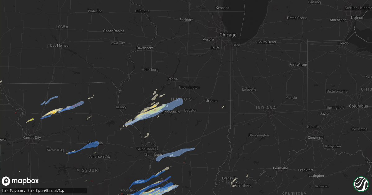
Hail Map in Illinois on October 24, 2021
Get this storm
October 24 map
$229
one time, instant access
Download today. No call, no setup
Keep the $229
Bought the map and want the full workflow? Apply the entire $229 to a subscription within 7 days. None of it is wasted.
Every map, not just this one
This buys you this map. Subscription and you get every map we run, in the markets you choose from a few cities to whole states to nationwide. Plus real-time alerts the moment a storm fires.
Contact data
Name, contact info, occupancy, even credit band for addresses in the footprint. You go from where it hit to who to call.
Become the source they trust
Unlimited branding weather history reports on demand. You already have the documented answer ready for the property owner, and you are the one who showed up with it.
Property data and RoofTrace estimates
Pull up any address you have got, its value and the exact code rules for that jurisdiction, straight from One Click Code. Then RoofTrace estimates the squares, pitch, and roof value, priced the way you price.
Storm reports in Illinois
Illinois
| Date | Description |
|---|---|
| 10/24/20216:47 PM CDT | Power lines down. Time estimated by radar. |
| 10/24/20216:45 PM CDT | Time estimated. |
| 10/24/20216:44 PM CDT | A local report indicates 1.00 inch wind near LITERBERRY |
| 10/24/20216:34 PM CDT | Relayed by broadcast media. Tree reported down over il 123 near downtown. |
| 10/24/20216:25 PM CDT | A local report indicates 1.75 inch wind near LITERBERRY |
| 10/24/20216:25 PM CDT | A local report indicates 60 MPH wind near LITERBERRY |
| 10/24/20216:17 PM CDT | Tree and power line damage. Time estimated. |
| 10/24/20216:16 PM CDT | Damage was reported along the length of vandalia road. Trees were down. A facade was torn off a church. |
| 10/24/20216:15 PM CDT | Trees and power lines down. |
| 10/24/20216:15 PM CDT | A local report indicates 60 MPH wind near DOWNS |
| 10/24/20216:05 PM CDT | Large... Healthy tree uprooted and fell on metal shed. |
| 10/24/20215:55 PM CDT | Estimated 55-60 mph winds. Small branches down. |
| 10/24/20215:45 PM CDT | Several trees and power lines down. |
| 10/24/20215:39 PM CDT | Power lines down in griggsville. Time estimated from radar. |
| 10/24/20215:23 PM CDT | At least 10 medium to small sized trees uprooted near highway 54. |
| 10/24/20215:20 PM CDT | Tree limbs blown down. Time estimated. |
| 10/24/20215:00 PM CDT | Reported at central illinois regional airport. |
| 10/24/20215:57 AM CDT | At 1057 PM CDT, severe thunderstorms were located along a line extending from near St. Elmo to Farina to near Omega, moving east at 50 mph. HAZARD...60 mph wind gusts and nickel size hail. SOURCE...Radar indicated. IMPACT...Expect damage to roofs, siding, and trees. Severe thunderstorms will be near... Altamont, Edgewood and Iola around 1105 PM CDT. Watson around 1115 PM CDT.Other locations in the path of these severe thunderstorms includeLouisville, Bible Grove, Teutopolis, Dieterich, Montrose and SailorSprings.This includes the following highways... Interstate 57 between mile markers 142 and 164. Interstate 70 between mile markers 79 and 104. |
| 10/24/20215:54 AM CDT | At 1054 PM CDT, a severe thunderstorm was located near Marble Hill, moving east at 40 mph. HAZARD...60 mph wind gusts. SOURCE...Radar indicated. IMPACT...Expect damage to roofs, siding, and trees. This severe thunderstorm will be near... Bollinger Mill State Historic Site and Burfordville around 1110 PM CDT.Other locations in the path of this severe thunderstorm includeMillersville, Jackson and Trail Of Tears State Park.This includes Interstate 55 between Mile Markers 99 and 115. |
| 10/24/20215:40 AM CDT | At 1040 PM CDT, severe thunderstorms were located along a line extending from near Vandalia to near Shobonier to near Fairman, moving east at 55 mph. HAZARD...60 mph wind gusts. SOURCE...Radar indicated. IMPACT...Expect damage to roofs, siding, and trees. Severe thunderstorms will be near... Kinmundy and Brownstown around 1050 PM CDT. St. Elmo and Farina around 1055 PM CDT.This includes the following highways... Interstate 70 in Illinois between exits 68 and 76. Interstate 57 in Illinois between exits 127 and 135. |
| 10/24/20215:13 AM CDT | At 1013 PM CDT, severe thunderstorms were located along a line extending from near Pocahontas to near Jamestown to Beckemeyer, moving east at 50 mph. HAZARD...60 mph wind gusts. SOURCE...Radar indicated. IMPACT...Expect damage to roofs, siding, and trees. Severe thunderstorms will be near... Mulberry Grove and Boulder around 1030 PM CDT.Other locations in the path of these severe thunderstorms includeFairman, Vandalia, Patoka, Shobonier, Brownstown, St. Elmo, Kinmundy,Farina and Wrights Corner.This includes the following highways... Interstate 70 in Illinois between exits 61 and 76. Interstate 57 in Illinois between exits 127 and 135.This also includes Carlyle Lake Recreational Area. |
| 10/24/20214:33 AM CDT | At 932 PM CDT, a severe thunderstorm was located near Cobalt, or 7 miles east of Fredericktown, moving east at 40 mph. HAZARD...60 mph wind gusts and quarter size hail. SOURCE...Radar indicated. IMPACT...Hail damage to vehicles is expected. Expect wind damage to roofs, siding, and trees. This severe thunderstorm will be near... Alliance around 945 PM CDT.Other locations in the path of this severe thunderstorm includeAltenburg.This includes Interstate 55 between Mile Markers 107 and 126. |
| 10/24/20212:39 AM CDT | At 739 PM CDT, a severe thunderstorm was located near Irondale, moving northeast at 35 mph. HAZARD...60 mph wind gusts and quarter size hail. SOURCE...Radar indicated. IMPACT...Hail damage to vehicles is expected. Expect wind damage to roofs, siding, and trees. This severe thunderstorm will be near... Leadwood around 750 PM CDT. Bonne Terre and Desloge around 755 PM CDT.Other locations in the path of this severe thunderstorm includeOlympian Village.This includes Interstate 55 in Missouri between exits 157 and 174. This also includes St. Francois State Park. |
| 10/24/20212:04 AM CDT | At 704 PM CDT, severe thunderstorms were located along a line extending from near Delavan to near Sherman, moving northeast at 45 mph. HAZARD...60 mph wind gusts and quarter size hail. SOURCE...Radar indicated. IMPACT...Hail damage to vehicles is expected. Expect wind damage to roofs, siding, and trees. Severe thunderstorms will be near... Emden around 710 PM CDT. Armington around 715 PM CDT.Other locations in the path of these severe thunderstorms includeMount Pulaski, Latham, Chestnut, Bloomington, Beason and Kenney.This includes the following highways... Interstate 155 between mile markers 0 and 13. Interstate 55 between mile markers 106 and 155. Interstate 72 between mile markers 105 and 117. |
| 10/24/20212:00 AM CDT | At 700 PM CDT, a severe thunderstorm was located near Farber, moving northeast at 45 mph. HAZARD...60 mph wind gusts and penny size hail. SOURCE...Radar indicated. IMPACT...Expect damage to roofs, siding, and trees. This severe thunderstorm will be near... Curryville and Spencerburg around 715 PM CDT. Bowling Green around 720 PM CDT.Other locations in the path of this severe thunderstorm includeTarrants and Louisiana. |
| 10/24/20211:28 AM CDT | At 628 PM CDT, severe thunderstorms were located along a line extending from near Kilbourne to near Alexander, moving northeast at 40 mph. HAZARD...Golf ball size hail and 60 mph wind gusts. SOURCE...Trained weather spotters. IMPACT...People and animals outdoors will be injured. Expect hail damage to roofs, siding, windows, and vehicles. Expect wind damage to roofs, siding, and trees. Severe thunderstorms will be near... Kilbourne around 635 PM CDT. Greenview and Easton around 640 PM CDT.Other locations in the path of these severe thunderstorms includeMason City, Athens, San Jose, Sherman and Williamsville.This includes the following highways... Interstate 55 between mile markers 95 and 105. Interstate 72 between mile markers 68 and 93, and between milemarkers 101 and 104. |
| 10/24/20211:26 AM CDT | At 626 PM CDT, severe thunderstorms were located along a line extending from 6 miles northeast of Colfax to 6 miles west of Saybrook to near Heyworth, moving east at 50 mph. HAZARD...60 mph wind gusts. SOURCE...Trained weather spotters. IMPACT...Expect damage to roofs, siding, and trees. Severe thunderstorms will be near... Saybrook around 635 PM CDT.Other locations in the path of these severe thunderstorms include Fisher, Rantoul and Gifford.This includes the following highways... Interstate 57 between mile markers 249 and 257. Interstate 74 between mile markers 144 and 154. |
| 10/24/202112:56 AM CDT | At 556 PM CDT, a severe thunderstorm was located near Winchester, moving east at 45 mph. HAZARD...60 mph wind gusts and quarter size hail. SOURCE...Radar indicated. IMPACT...Hail damage to vehicles is expected. Expect wind damage to roofs, siding, and trees. This severe thunderstorm will be near... Chapin around 605 PM CDT. Jacksonville and Woodson around 615 PM CDT.Other locations in the path of this severe thunderstorm includeLiterberry, Alexander and Ashland.This includes Interstate 72 between mile markers 43 and 79. |
| 10/24/202112:39 AM CDT | At 539 PM CDT, a severe thunderstorm was located over Meredosia, or 13 miles north of Winchester, moving northeast at 50 mph. HAZARD...60 mph wind gusts and quarter size hail. SOURCE...Radar indicated. IMPACT...Hail damage to vehicles is expected. Expect wind damage to roofs, siding, and trees. This severe thunderstorm will be near... Chapin around 545 PM CDT. Arenzville around 550 PM CDT. Bluff Springs around 555 PM CDT.Other locations in the path of this severe thunderstorm includeLiterberry, Virginia and Chandlerville.This includes Interstate 72 between mile markers 43 and 46. |
| 10/23/202111:49 PM CDT | At 449 PM CDT, a severe thunderstorm was located over Spencerburg, moving northeast at 55 mph. HAZARD...60 mph wind gusts. SOURCE...Radar indicated. IMPACT...Expect damage to roofs, siding, and trees. This severe thunderstorm will be near... Bowling Green and Frankford around 455 PM CDT. Tarrants around 500 PM CDT.Other locations in the path of this severe thunderstorm includeLouisiana, Pike, Atlas and Pittsfield.This includes Interstate 72 between exits 31 and 35. |
| 10/23/202110:25 PM CDT | Relayed by broadcast media. Time estimated by radar. Tree fell on house. |
| 10/23/202110:00 PM CDT | Wcia storm-tracker reported tree in roadway. |
| 10/23/202110:00 PM CDT | Spotter reports estimated wind gust of 65 mph and pea sized hail. |
| 10/23/20219:54 PM CDT | Trees uprooted and snapped near i-64 at mile marker 59.5. Large tree on residence on chestnut road. Barn roof ripped off. |
| 10/23/20219:53 PM CDT | A few limb down on maple street. |
| 10/23/20219:50 PM CDT | Reports of 60 mph wind gusts... Medium tree branches down... And power outages near joyce drive. |
| 10/23/20219:47 PM CDT | Pole barn lifted... Flipped... And laid on a business 30 ft to the east. |
| 10/23/20219:45 PM CDT | Relayed by county ema. Small garage damaged. 52x100 machine shed destroyed. |
| 10/23/20219:45 PM CDT | From twitter: chester has lost its fire house. |
| 10/23/20219:44 PM CDT | Facebook report and photographs show roof of storage building at air force base storage was blown east onto adjacent house along state route 161 e near the intersection |
| 10/23/20219:44 PM CDT | Awos station kblv scott air force base. |
| 10/23/20219:41 PM CDT | Tree blocking dartmouth dr at whitehall dr. |
| 10/23/20219:41 PM CDT | Wind blew car off road. |
| 10/23/20219:31 PM CDT | Machine shed mangled and widespread tree damage. Debris also on the road. |
| 10/23/20219:25 PM CDT | Power lines down along route 150. |
| 10/23/20219:16 PM CDT | Large trees upwards of 18 inches in diameter have been uprooted. Small boats have been blown. Time estimated from radar. |
| 10/23/20217:04 PM CDT | Tree down on road. Time estimated. |
All States Impacted by Hail Map on October 24, 2021
Cities Impacted by Hail Map on October 24, 2021
- Breckenridge, MO
- Griggsville, IL
- Farmington, MO
- Doe Run, MO
- Bismarck, MO
- Middle Brook, MO
- Ironton, MO
- Belleview, MO
- Hamilton, MO
- Eminence, MO
- Hartshorn, MO
- Summersville, MO
- Atkins, AR
- Meredosia, IL
- Mammoth Spring, AR
- Thayer, MO
- Jacksonville, IL
- Virginia, IL
- Ashland, IL
- Arenzville, IL
- Hartsburg, MO
- Centertown, MO
- Jefferson City, MO
- Chillicothe, MO
- Lock Springs, MO
- Mooresville, MO
- Gallatin, MO
- Salem, MO
- Bunker, MO
- Potosi, MO
- Mineral Point, MO
- Belgrade, MO
- Cabool, MO
- Willow Springs, MO
- Sedalia, MO
- Bath, IL
- Havana, IL
- Browning, IL
- Astoria, IL
- Kirksville, MO
- Brashear, MO
- Pittsfield, IL
- New Salem, IL
- Winchester, IL
- Pleasant Plains, IL
- Tallula, IL
- Bluffs, IL
- Chambersburg, IL
- Petersburg, IL
- Alexander, IL
- Concord, IL
- Chapin, IL
- Patton, MO
- Fredericktown, MO
- Cedarville, AR
- Alma, AR
- Rudy, AR
- Uniontown, AR
- Van Buren, AR
- Muldrow, OK
- Natural Dam, AR
- Fieldon, IL
- Jerseyville, IL
- Farrar, MO
- Perryville, MO
- Friedheim, MO
- Sedgewickville, MO
- Uniontown, MO
- Frohna, MO
- Dearborn, MO
- Edgerton, MO
- Gower, MO
- Plattsburg, MO
- Mountain View, MO
- Arcadia, MO
- Grandview, IN
- Lamar, IN
- Evanston, IN
- Tahlequah, OK
- Park Hill, OK
- Aviston, IL
- Trenton, IL
- Breese, IL
- Curryville, MO
- Jacob, IL
- Oak Ridge, MO
- Lesterville, MO
- Saint Mary, MO
- Redford, MO
- Gorham, IL
- Ava, IL
- Ellington, MO
- Marquand, MO
- Annapolis, MO
- Vulcan, MO
- Des Arc, MO
- Stilwell, OK
- Cookson, OK
- Bunch, OK
- Muskogee, OK
- Fort Gibson, OK
- Kane, IL
- Carrollton, IL
- Prairie Du Rocher, IL
- Red Bud, IL
- Henderson, KY
- Sidell, IL
- Beardstown, IL
- Louisiana, MO
- New Canton, IL
- Frankford, MO
- Chandlerville, IL
- Rockport, IL
- Versailles, IL
- Barry, IL
- Bowling Green, MO
- Pleasant Hill, IL
- Hollister, MO
- Omaha, AR
- Ridgedale, MO
- Excello, MO
- Huntsville, MO
- Midland, AR
- Huntington, AR
- Cameron, OK
- Hackett, AR
- Centerville, KS
- Gainesville, MO
- Lead Hill, AR
- Protem, MO
- Cedarcreek, MO
- Kirbyville, MO
- Peel, AR
- Mountain Home, AR
- Clarkridge, AR
- Udall, MO
- Gepp, AR
- Oakland, AR
- Bakersfield, MO
- Caulfield, MO
- West Plains, MO
- Gamaliel, AR
- Viola, AR
- Pontiac, MO
- Moody, MO
- Newburgh, IN
- Spottsville, KY
- Baldwin, IL
- Marissa, IL
- Glenallen, MO
- Sainte Genevieve, MO
- Bloomsdale, MO
- Sallisaw, OK
- Ipava, IL
- Lewistown, IL
- Park Hills, MO
- Irondale, MO
- Bonne Terre, MO
- Doniphan, MO
- Gatewood, MO
- Franklin, IL
- Reed, KY
- Centerville, MO
- Black, MO
- Grandin, MO
- Hamburg, IA
- Koshkonong, MO
- Salem, AR
- Couch, MO
- Sturkie, AR
- Millersville, MO
- Marble Hill, MO
- New Athens, IL
- Sparta, IL
- Blue Eye, MO
- Athens, IL
- Murphysboro, IL
- Linwood, NE
- Prague, NE
- Kidder, MO
- Chula, MO
- Cameron, MO
- Jamesport, MO
- Hartford, AR
- Macon, MO
- Easton, IL
- Kilbourne, IL
- Strafford, MO
- Oakdale, IL
- Stoutland, MO
- Otterville, MO
- Smithton, MO
- Wheeling, MO
- Linneus, MO
- Kingston, MO
- Turney, MO
- Lathrop, MO
- Pattonsburg, MO
- Gilman City, MO
- Jameson, MO
- Coffey, MO
- Spickard, MO
- Bethany, MO
- Trenton, MO
- Green Castle, MO
- New Boston, MO
- Meadville, MO
- Browning, MO
- Purdin, MO
- Winigan, MO
- Brookfield, MO
- Novinger, MO
- Milan, MO
- Prairie Home, MO
- Jamestown, MO
- Bunceton, MO
- Boonville, MO
- Wooldridge, MO
- Rocheport, MO
- Columbia, MO
- Richland, MO
- Troy, KS
- Woodland, WA
- La Center, WA
- Vandalia, IL
- Highland, IL
- Lebanon, IL
- Beckemeyer, IL
- Dupo, IL
- Germantown, IL
- East Carondelet, IL
- Alma, IL
- Millstadt, IL
- Greenville, IL
- Patoka, IL
- East Saint Louis, IL
- Columbia, IL
- Kinmundy, IL
- Keyesport, IL
- O'Fallon, IL
- Carlyle, IL
- Vernon, IL
- Belleville, IL
- Saint Jacob, IL
- Fairview Heights, IL
- Summerfield, IL
- Pocahontas, IL
- Leadwood, MO
- Festus, MO
- Evansville, IL
- French Village, MO
- Bixby, MO
- Chester, IL
- Pilot Knob, MO
- Percy, IL
- Steeleville, IL
- Rockwood, IL
- Winona, MO
- Piedmont, MO
- Sherman, IL
- Greenview, IL
- Mount Pulaski, IL
- Williamsville, IL
- Elkhart, IL
- Lincoln, IL
- Springfield, IL
- Beason, IL
- Middletown, IL
- Cantrall, IL
- Chestnut, IL
- New Holland, IL
- Zalma, MO
- Chaffee, MO
- Wappapello, MO
- McGee, MO
- Gipsy, MO
- Greenville, MO
- Lowndes, MO
- Cape Girardeau, MO
- Advance, MO
- Whitewater, MO
- Richview, IL


