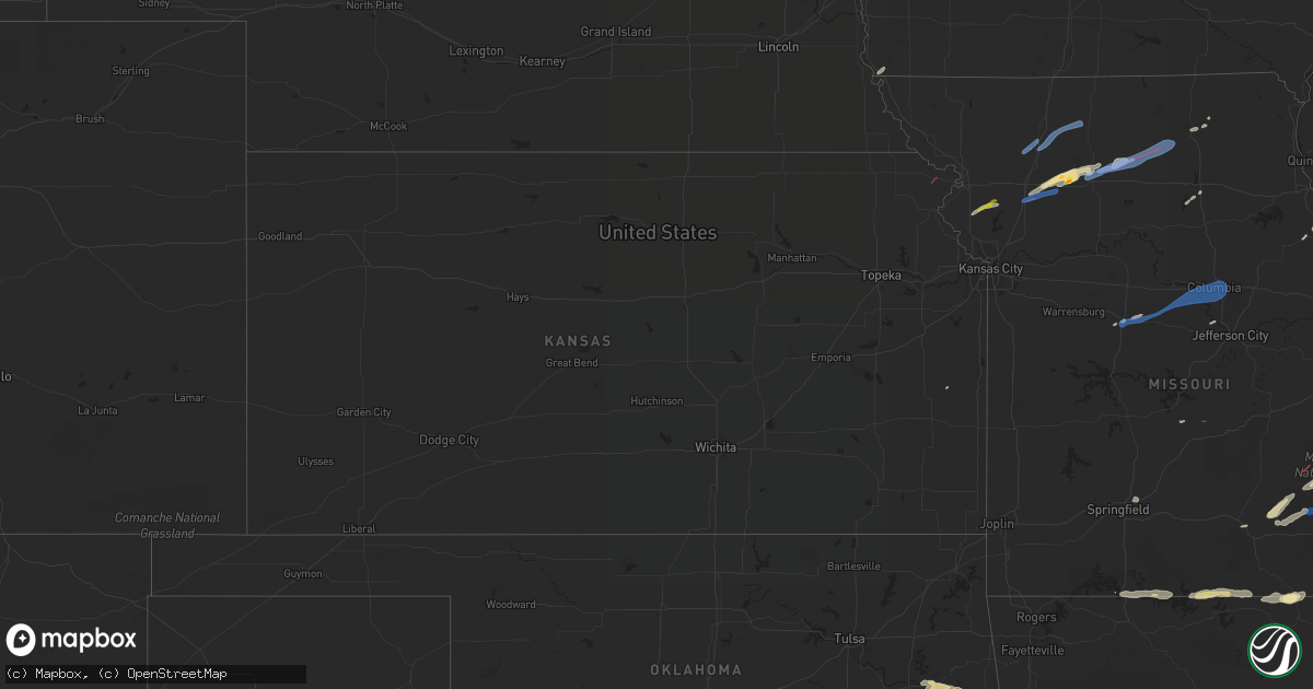
Hail Map in Kansas on October 24, 2021
Get this storm
October 24 map
$229
one time, instant access
Download today. No call, no setup
Keep the $229
Bought the map and want the full workflow? Apply the entire $229 to a subscription within 7 days. None of it is wasted.
Every map, not just this one
This buys you this map. Subscription and you get every map we run, in the markets you choose from a few cities to whole states to nationwide. Plus real-time alerts the moment a storm fires.
Contact data
Name, contact info, occupancy, even credit band for addresses in the footprint. You go from where it hit to who to call.
Become the source they trust
Unlimited branding weather history reports on demand. You already have the documented answer ready for the property owner, and you are the one who showed up with it.
Property data and RoofTrace estimates
Pull up any address you have got, its value and the exact code rules for that jurisdiction, straight from One Click Code. Then RoofTrace estimates the squares, pitch, and roof value, priced the way you price.
Storm reports in Kansas
Kansas
| Date | Description |
|---|---|
| 10/24/20212:12 PM CDT | Emd reported visual of tornado with debris. |
| 10/24/20217:37 AM CDT | At 1237 AM CDT, a severe thunderstorm was located 5 miles south of Circleville, moving northeast at 35 mph. HAZARD...Quarter size hail. SOURCE...Radar indicated. IMPACT...Damage to vehicles is expected. Locations impacted include... Holton and Whiting. |
| 10/23/20219:05 PM CDT | At 204 PM CDT, a severe thunderstorm was located over Troy, moving northeast at 45 mph. HAZARD...60 mph wind gusts and quarter size hail. SOURCE...Radar indicated. IMPACT...Hail damage to vehicles is expected. Expect wind damage to roofs, siding, and trees. Locations impacted include... St. Joseph, Savannah, Wathena, Elwood, Troy, Country Club Villa, Country Club, Amazonia, Bolckow, Rosendale, Cosby, Severance, Rea, St. Joseph Airport, Bendena, Helena and Fanning.This includes the following highways... Interstate 29 between mile markers 49 and 67. Interstate 229 between mile markers 7 and 14. |
| 10/23/20218:04 PM CDT | At 103 AM CDT, a severe thunderstorm was located near Muscotah, or 9 miles east of Holton, moving northeast at 40 mph. HAZARD...Quarter size hail. SOURCE...Radar indicated. IMPACT...Damage to vehicles is expected. Locations impacted include... Atchison, Effingham, Lancaster, Muscotah, Farmington, Huron and Arrington. |
All States Impacted by Hail Map on October 24, 2021
Cities Impacted by Hail Map on October 24, 2021
- Breckenridge, MO
- Griggsville, IL
- Farmington, MO
- Doe Run, MO
- Bismarck, MO
- Middle Brook, MO
- Ironton, MO
- Belleview, MO
- Hamilton, MO
- Eminence, MO
- Hartshorn, MO
- Summersville, MO
- Atkins, AR
- Meredosia, IL
- Mammoth Spring, AR
- Thayer, MO
- Jacksonville, IL
- Virginia, IL
- Ashland, IL
- Arenzville, IL
- Hartsburg, MO
- Centertown, MO
- Jefferson City, MO
- Chillicothe, MO
- Lock Springs, MO
- Mooresville, MO
- Gallatin, MO
- Salem, MO
- Bunker, MO
- Potosi, MO
- Mineral Point, MO
- Belgrade, MO
- Cabool, MO
- Willow Springs, MO
- Sedalia, MO
- Bath, IL
- Havana, IL
- Browning, IL
- Astoria, IL
- Kirksville, MO
- Brashear, MO
- Pittsfield, IL
- New Salem, IL
- Winchester, IL
- Pleasant Plains, IL
- Tallula, IL
- Bluffs, IL
- Chambersburg, IL
- Petersburg, IL
- Alexander, IL
- Concord, IL
- Chapin, IL
- Patton, MO
- Fredericktown, MO
- Cedarville, AR
- Alma, AR
- Rudy, AR
- Uniontown, AR
- Van Buren, AR
- Muldrow, OK
- Natural Dam, AR
- Fieldon, IL
- Jerseyville, IL
- Farrar, MO
- Perryville, MO
- Friedheim, MO
- Sedgewickville, MO
- Uniontown, MO
- Frohna, MO
- Dearborn, MO
- Edgerton, MO
- Gower, MO
- Plattsburg, MO
- Mountain View, MO
- Arcadia, MO
- Grandview, IN
- Lamar, IN
- Evanston, IN
- Tahlequah, OK
- Park Hill, OK
- Aviston, IL
- Trenton, IL
- Breese, IL
- Curryville, MO
- Jacob, IL
- Oak Ridge, MO
- Lesterville, MO
- Saint Mary, MO
- Redford, MO
- Gorham, IL
- Ava, IL
- Ellington, MO
- Marquand, MO
- Annapolis, MO
- Vulcan, MO
- Des Arc, MO
- Stilwell, OK
- Cookson, OK
- Bunch, OK
- Muskogee, OK
- Fort Gibson, OK
- Kane, IL
- Carrollton, IL
- Prairie Du Rocher, IL
- Red Bud, IL
- Henderson, KY
- Sidell, IL
- Beardstown, IL
- Louisiana, MO
- New Canton, IL
- Frankford, MO
- Chandlerville, IL
- Rockport, IL
- Versailles, IL
- Barry, IL
- Bowling Green, MO
- Pleasant Hill, IL
- Hollister, MO
- Omaha, AR
- Ridgedale, MO
- Excello, MO
- Huntsville, MO
- Midland, AR
- Huntington, AR
- Cameron, OK
- Hackett, AR
- Centerville, KS
- Gainesville, MO
- Lead Hill, AR
- Protem, MO
- Cedarcreek, MO
- Kirbyville, MO
- Peel, AR
- Mountain Home, AR
- Clarkridge, AR
- Udall, MO
- Gepp, AR
- Oakland, AR
- Bakersfield, MO
- Caulfield, MO
- West Plains, MO
- Gamaliel, AR
- Viola, AR
- Pontiac, MO
- Moody, MO
- Newburgh, IN
- Spottsville, KY
- Baldwin, IL
- Marissa, IL
- Glenallen, MO
- Sainte Genevieve, MO
- Bloomsdale, MO
- Sallisaw, OK
- Ipava, IL
- Lewistown, IL
- Park Hills, MO
- Irondale, MO
- Bonne Terre, MO
- Doniphan, MO
- Gatewood, MO
- Franklin, IL
- Reed, KY
- Centerville, MO
- Black, MO
- Grandin, MO
- Hamburg, IA
- Koshkonong, MO
- Salem, AR
- Couch, MO
- Sturkie, AR
- Millersville, MO
- Marble Hill, MO
- New Athens, IL
- Sparta, IL
- Blue Eye, MO
- Athens, IL
- Murphysboro, IL
- Linwood, NE
- Prague, NE
- Kidder, MO
- Chula, MO
- Cameron, MO
- Jamesport, MO
- Hartford, AR
- Macon, MO
- Easton, IL
- Kilbourne, IL
- Strafford, MO
- Oakdale, IL
- Stoutland, MO
- Otterville, MO
- Smithton, MO
- Wheeling, MO
- Linneus, MO
- Kingston, MO
- Turney, MO
- Lathrop, MO
- Pattonsburg, MO
- Gilman City, MO
- Jameson, MO
- Coffey, MO
- Spickard, MO
- Bethany, MO
- Trenton, MO
- Green Castle, MO
- New Boston, MO
- Meadville, MO
- Browning, MO
- Purdin, MO
- Winigan, MO
- Brookfield, MO
- Novinger, MO
- Milan, MO
- Prairie Home, MO
- Jamestown, MO
- Bunceton, MO
- Boonville, MO
- Wooldridge, MO
- Rocheport, MO
- Columbia, MO
- Richland, MO
- Troy, KS
- Woodland, WA
- La Center, WA
- Vandalia, IL
- Highland, IL
- Lebanon, IL
- Beckemeyer, IL
- Dupo, IL
- Germantown, IL
- East Carondelet, IL
- Alma, IL
- Millstadt, IL
- Greenville, IL
- Patoka, IL
- East Saint Louis, IL
- Columbia, IL
- Kinmundy, IL
- Keyesport, IL
- O'Fallon, IL
- Carlyle, IL
- Vernon, IL
- Belleville, IL
- Saint Jacob, IL
- Fairview Heights, IL
- Summerfield, IL
- Pocahontas, IL
- Leadwood, MO
- Festus, MO
- Evansville, IL
- French Village, MO
- Bixby, MO
- Chester, IL
- Pilot Knob, MO
- Percy, IL
- Steeleville, IL
- Rockwood, IL
- Winona, MO
- Piedmont, MO
- Sherman, IL
- Greenview, IL
- Mount Pulaski, IL
- Williamsville, IL
- Elkhart, IL
- Lincoln, IL
- Springfield, IL
- Beason, IL
- Middletown, IL
- Cantrall, IL
- Chestnut, IL
- New Holland, IL
- Zalma, MO
- Chaffee, MO
- Wappapello, MO
- McGee, MO
- Gipsy, MO
- Greenville, MO
- Lowndes, MO
- Cape Girardeau, MO
- Advance, MO
- Whitewater, MO
- Richview, IL


