Hail Map in Missouri on October 17, 2012
Get this storm
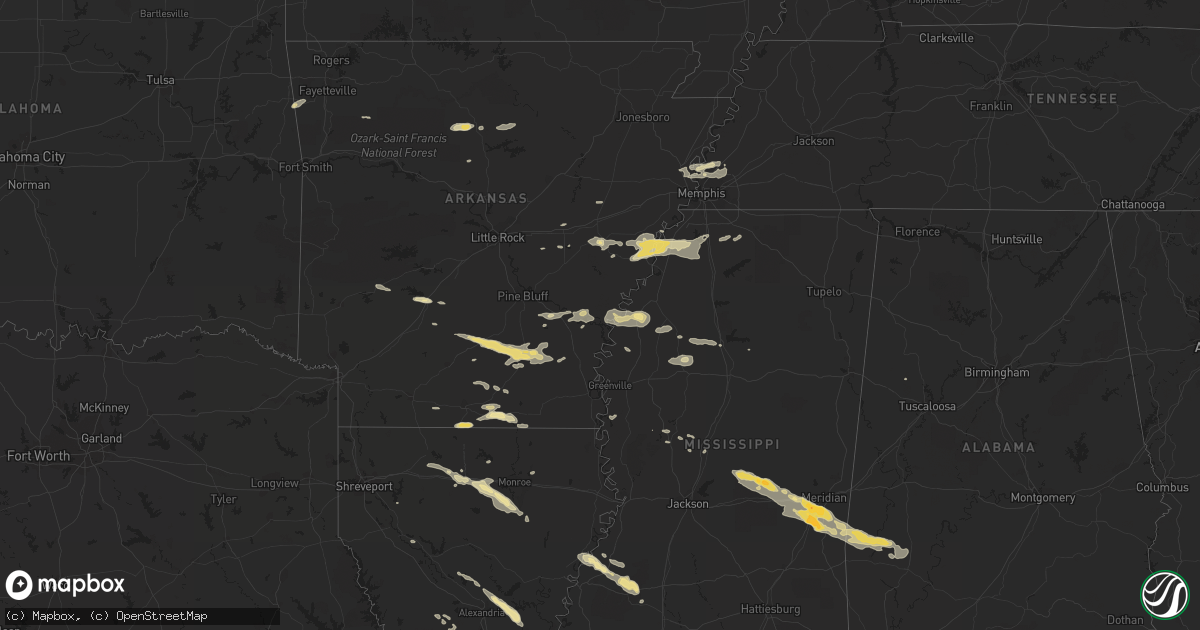
October 17 map
$229
one time, instant access
Download today. No call, no setup
Keep the $229
Bought the map and want the full workflow? Apply the entire $229 to a subscription within 7 days. None of it is wasted.
Every map, not just this one
This buys you this map. Subscription and you get every map we run, in the markets you choose from a few cities to whole states to nationwide. Plus real-time alerts the moment a storm fires.
Contact data
Name, contact info, occupancy, even credit band for addresses in the footprint. You go from where it hit to who to call.
Become the source they trust
Unlimited branding weather history reports on demand. You already have the documented answer ready for the property owner, and you are the one who showed up with it.
Property data and RoofTrace estimates
Pull up any address you have got, its value and the exact code rules for that jurisdiction, straight from One Click Code. Then RoofTrace estimates the squares, pitch, and roof value, priced the way you price.
Storm reports in Missouri
Missouri
| Date | Description |
|---|---|
| 10/17/20125:45 PM CDT | Trees down with the thunderstorm line. |
| 10/17/20125:38 PM CDT | A local report indicates 62 MPH wind near DE SOTO |
| 10/17/20125:30 PM CDT | Trees down near cc and olive in the westport area. |
| 10/17/20125:23 PM CDT | Trees down near fee fee road and olive blvd. |
| 10/17/20125:23 PM CDT | A local report indicates 60 MPH wind near 3 SSW ORCHARD FARMS |
| 10/17/20125:10 PM CDT | Winds estimated to 60 mph with 3-inch limbs down. |
| 10/17/20125:05 PM CDT | Winds estimated to 60 mph with 3-inch limbs down. |
| 10/17/20124:55 PM CDT | A local report indicates 61 MPH wind near MOSCOW MILLS |
| 10/17/20124:55 PM CDT | Winds estimated up to 50 mph. |
| 10/17/20124:53 PM CDT | Goal posts at progress park blown over. |
| 10/17/20124:53 PM CDT | Several power lines blown down just south of i-70 on hepperman road. |
| 10/17/20124:44 PM CDT | Trees down on south side of i-70 near foristell. |
| 10/17/20124:42 PM CDT | Power lines down throughout the county with a report of an electirical fire. |
| 10/17/20124:36 PM CDT | Winds estimated up to 50 mph. |
| 10/17/20124:30 PM CDT | Power lines down throughout the county with a report of an electirical fire. |
| 10/17/20124:24 PM CDT | Numerous trees and large tree limbs along with a few power lines downed in the gerald area. |
| 10/17/20124:20 PM CDT | 8-10 inch diameter limbs down off of tree tops. 0.5 inch hail lasted about 2 minutes. |
| 10/17/20124:18 PM CDT | Numerous trees and large tree limbs along with a few power lines downed in the gerald area. |
| 10/17/20124:15 PM CDT | 8-10 inch diameter limbs down off of tree tops. 0.5 inch hail lasted about 2 minutes. |
| 10/17/20124:05 PM CDT | Small tree limbs down in owensville. Winds estimated up to 50 mph with visibility down to as low as 200 yards. |
| 10/17/20124:02 PM CDT | *** 2 inj *** two minor injuries...treated and released at the scene. Twelve buildings with minor to moderate damage. Post office heavily damaged...one employee briefly |
| 10/17/20124:02 PM CDT | Several 1 to 2 foot diameter trees snapped |
| 10/17/20124:00 PM CDT | Houses and sheds damaged...car damaged in town. |
| 10/17/20123:21 PM CDT | Large limbs down on highway 5 south of lebanon and power pole down. |
| 10/17/20123:00 PM CDT | A couple trees were blown down in the marshfield area. |
| 10/17/20122:41 PM CDT | Large limbs down on page street. |
| 10/17/20122:40 PM CDT | A local report indicates 60 MPH wind near 5 NE SPRINGFIELD |
| 10/17/20122:33 PM CDT | Estimated wind gusts up to 65 mph on the west side of springfield |
| 10/17/20122:30 PM CDT | Reports of damage in the area of alliance and ee hwy just southeast of the springfield airport. Damage to trailers and metal buildings. Damage to siding panels and a tr |
| 10/17/20122:29 PM CDT | Small buidlings blown down and 70 mph winds estimated. |
| 10/17/20122:27 PM CDT | Reports of two barns destroyed west of pleasant hope near 175th north of highway 215 between brighton and pleasant hope. |
| 10/17/20122:25 PM CDT | Large limb down on highway n just south of i-44 in the road way. Winds were estimated from spotters at 65 mph. |
| 10/17/20122:25 PM CDT | Several trees uprooted between brighton and pleasant hope and heavy damage to outbuildings and barns |
| 10/17/20122:22 PM CDT | Roof completely blown off barn and spotters relayed estimated winds up to 75 mph from another report near pleasant hope. |
| 10/17/20122:18 PM CDT | Winds reported at exit 69 on interstate 44. |
| 10/17/20122:15 PM CDT | Above ground pool and swingset damaged from winds. |
| 10/17/20122:10 PM CDT | Tree uprooted in ash grove |
| 10/17/20122:07 PM CDT | Tree down on a house and the awning was ripped off the house. |
All States Impacted by Hail Map on October 17, 2012
Cities Impacted by Hail Map on October 17, 2012
- Warren, AR
- Thornton, AR
- Fordyce, AR
- New Edinburg, AR
- Junction City, AR
- Spearsville, LA
- El Dorado, AR
- Lillie, LA
- Arkadelphia, AR
- Bogalusa, LA
- Angie, LA
- Hermitage, AR
- Ruston, LA
- Grambling, LA
- Fayette, MS
- Natchez, MS
- Lorman, MS
- Waterproof, LA
- Leslie, AR
- Dennard, AR
- Marshall, AR
- Memphis, TN
- Munford, TN
- Drummonds, TN
- Millington, TN
- Clinton, AR
- Marksville, LA
- Effie, LA
- Deville, LA
- Pineville, LA
- Pollock, LA
- Center Point, LA
- Lexa, AR
- West Helena, AR
- Newton, MS
- Decatur, MS
- Gilbertown, AL
- Thomasville, AL
- Toxey, AL
- Needham, AL
- Butler, AL
- Campbell, AL
- Tunica, MS
- Schlater, MS
- Quitman, MS
- Enterprise, MS
- Stonewall, MS
- Yazoo City, MS
- Carlisle, AR
- Gould, AR
- Tichnor, AR
- Gillett, AR
- Amity, AR
- Glenwood, AR
- Gunnison, MS
- Alligator, MS
- Shelby, MS
- Duncan, MS
- Huttig, AR
- Strong, AR
- Simsboro, LA
- Arcadia, LA
- Elmer, LA
- Hineston, LA
- Grenada, MS
- Smithdale, MS
- Grady, AR
- Malvern, AR
- Donaldson, AR
- Boyce, LA
- Brinkley, AR
- Clarendon, AR
- Holly Grove, AR
- Wilmar, AR
- Marble Hill, MO
- Kountze, TX
- Dermott, AR
- Tillar, AR
- Coldwater, MS
- Poplar Grove, AR
- Marianna, AR
- Dundee, MS
- Tilly, AR
- Louise, MS
- Charleston, MS
- Pickens, MS
- Hermann, MO
- Lake Arthur, LA
- Jennings, LA
- Forest, MS
- Walnut Grove, MS
- Conehatta, MS
- Hampton, AR
- Reeves, LA
- Ragley, LA
- Philipp, MS
- Holcomb, MS
- Stockton, MO
- Hickory, MS
- Lena, MS
- Atoka, TN
- Benton, MS
- Ringgold, LA
- McCall Creek, MS
- Meadville, MS
- Roxie, MS
- Union Church, MS
- Rose Hill, MS
- Grove Hill, AL
- Lake, MS
- Louin, MS
- Lawrence, MS
- Coffeeville, AL
- Chunky, MS
- Meridian, MS
- Crossett, AR
- Hamburg, AR
- Eros, LA
- West Monroe, LA
- Glenmora, LA
- Greenwood, MS
- Banks, AR
- Kingsland, AR
- Monticello, AR
- Rison, AR
- Bearden, AR
- Sparkman, AR
- Columbia, LA
- Choudrant, LA
- Calhoun, LA
- Monroe, LA
- Byhalia, MS
- Collinston, LA
- Drew, MS
- Tutwiler, MS
- Parchman, MS
- Jackson, MO
- Cape Girardeau, MO
- Turrell, AR
- Marion, AR
- Crawfordsville, AR
- Arlington, TN
- Leesville, LA
- Saint Paul, AR
- Moreauville, LA
- Poplarville, MS
- Senatobia, MS
- Helena, AR
- Hernando, MS
- Sarah, MS
- Yorktown, AR
- Fox, AR
- Shirley, AR
- Mountain View, AR
- Edgemont, AR
- Ville Platte, LA
- Stuttgart, AR
- Hazen, AR
- Chatham, MS
- Hollandale, MS
- Saucier, MS
- Lincoln, AR
- Westville, OK
- Elkville, IL
- Dowell, IL
- Du Quoin, IL
- Bentley, LA
- Biscoe, AR
- Bernice, LA
- Dubach, LA
- Homer, LA
- Athens, LA
- Carthage, TX
- Downsville, LA
- Snow Lake, AR
- Mound Bayou, MS
- Clarksdale, MS
- Aubrey, AR
- Dry Prong, LA
- Star City, AR
- Coushatta, LA
- Center Ridge, AR
- Vaughan, MS
- Stilwell, OK
- Summers, AR
- Colfax, LA
- Atlanta, LA
- Perkinston, MS
- McHenry, MS
- Hunter, AR
- Cotton Plant, AR
- Watson, AR
- Cleveland, MS
- Fayette, AL
- Marvell, AR
- Brickeys, AR
- Jersey, AR
- Magnolia, AR
- Gore Springs, MS
- De Valls Bluff, AR


