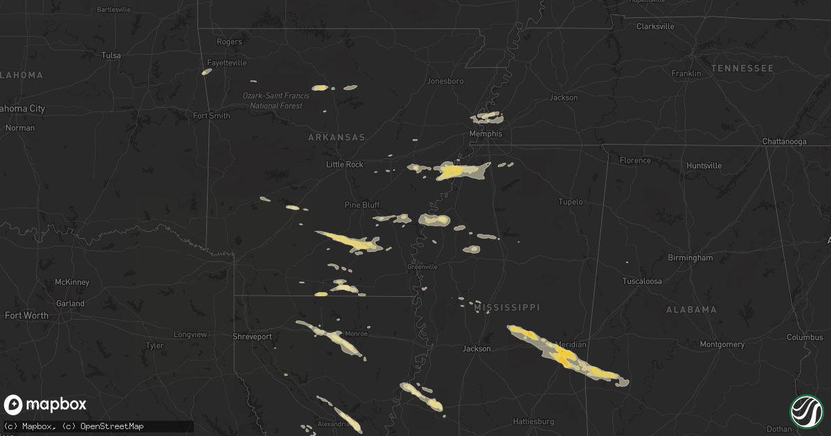
Hail Map in Mississippi on October 17, 2012
Get this storm
October 17 map
$229
one time, instant access
Download today. No call, no setup
Keep the $229
Bought the map and want the full workflow? Apply the entire $229 to a subscription within 7 days. None of it is wasted.
Every map, not just this one
This buys you this map. Subscription and you get every map we run, in the markets you choose from a few cities to whole states to nationwide. Plus real-time alerts the moment a storm fires.
Contact data
Name, contact info, occupancy, even credit band for addresses in the footprint. You go from where it hit to who to call.
Become the source they trust
Unlimited branding weather history reports on demand. You already have the documented answer ready for the property owner, and you are the one who showed up with it.
Property data and RoofTrace estimates
Pull up any address you have got, its value and the exact code rules for that jurisdiction, straight from One Click Code. Then RoofTrace estimates the squares, pitch, and roof value, priced the way you price.
Storm reports in Mississippi
Mississippi
| Date | Description |
|---|---|
| 10/17/20126:50 PM CDT | Large tree over road at intersection of cobb and hwy 61. Powerpoles down on hwy 4. |
| 10/17/20122:09 AM CDT | Power lines down |
| 10/17/20121:55 AM CDT | Reports of nickel and quarter sized hail |
| 10/17/20121:52 AM CDT | One house was destroyed. Ten homes had wind damage and some of them had trees on them. Approximately six poultry houses were damaged. A number of trees and utility line |
| 10/17/20121:50 AM CDT | Public report of hailstones up to golfball size. Relayed through wtok in meridian. |
| 10/17/20121:42 AM CDT | Half dollar to golf ball sized hail reported |
| 10/17/20121:42 AM CDT | Tree down across new hope rd |
| 10/17/20121:13 AM CDT | Damage to a couple homes on cr 505 and lots of trees and powerlines down...possible tornado. |
| 10/17/20121:12 AM CDT | Tornado caused mostly tree damage except where it crossed cr 519. A mobile home was pushed off its foundation. A metal and wood frame building was destroyed and a roof |
| 10/17/20121:05 AM CDT | Dozens of trees and power lines down along with several sturctures damaged. Most damage occurred along newton-conehatta rd and caney creek rd. |
| 10/17/20121:01 AM CDT | This tornado touched down just to the west of w northside dr. And tracked ene. As the tornado neared and crossed w northside dr. Almost a dozen hardwood trees were snap |
| 10/17/20121:00 AM CDT | Structure damage on jim owens rd along with trees and powerlines down. |
| 10/17/201212:55 AM CDT | *** 1 inj *** person trapped in mobile home with tree on top on russell community rd. Lots of trees down in the area as well. |
| 10/17/201212:55 AM CDT | A mobile home was destroyed on the northern end of conehatta road near jim owens road. Four large transmission towers were blown down on jim owens road. |
| 10/17/201212:55 AM CDT | Tree down on a house ne of forest...likely tornado |
| 10/17/201212:46 AM CDT | *** 1 inj *** tornado touched down along old jackson rd east of hillsboro and traveled ese through e scott county...entering w newton county just south of conehatta. To |
| 10/17/201212:40 AM CDT | Several trees down across hwy 487. Possible tornado. |
| 10/17/201212:35 AM CDT | Several trees down along hwy 35 |
| 10/17/201212:32 AM CDT | Two homes damaged and trees down along e frankling st. A couple chicken houses were damaged along hwy 16 e and a tree was down on a house. Possible tornado. |
| 10/17/201212:32 AM CDT | Tornado travelled roughly east along east franklin street and then across highway 16 where it lifted 2.5 miles east of carthage. Significant damage occurred to several |
| 10/17/201212:14 AM CDT | Trees and power lines down e and se of canton. |
| 10/17/201212:11 AM CDT | Wide but brief tornado that produced significant roof damage to two homes although most other damage limited to trees. Max wind speed 95 mph...path length half a mile.. |
| 10/17/201212:09 AM CDT | A few trees down. |
| 10/16/201211:30 PM CDT | Tree down on a home along myrleville rd |
| 10/16/201211:29 PM CDT | This tornado caused only tree damage in far ne yazoo county. Max wind speed 90 mph...path length 2 miles...max path width 250 yards. |
| 10/16/201211:08 PM CDT | Couple of trees and limbs down in town. |
| 10/16/201211:02 PM CDT | Heavy damage reported along lake city rd |
| 10/16/201210:56 PM CDT | Tornado damaged several outbuildings and travel trailers and snapped many trees. Max peak wind 90 mph...path length 2 miles...max path width 100 yards. |
| 10/16/201210:55 PM CDT | Tree fell on a powerline in the springhill community. |
| 10/16/201210:55 PM CDT | Tree fell on a powerline in montevista community. |
| 10/16/201210:50 PM CDT | Around louise and along county barn rd...mobile home damaged with another mobile home turned over...power lines down as well. |
| 10/16/201210:46 PM CDT | This tornado damaged several roofs and outbuildings south and west of louise. Max peak wind 110 mph...path length 3 miles...max path width 100 yards. |
| 10/16/201210:41 PM CDT | *** 5 inj *** 2 mobile homes destroyed along with other damaged homes along hwy 14...5 injuries. |
| 10/16/201210:40 PM CDT | *** 4 inj *** tornado touched down e of anguilla and ended 3 miles w of louise. Several mobile homes were heavily damaged or destroyed and dozens of power poles snapped |
| 10/16/201210:30 PM CDT | Boat overturned off a boat trailer and siding damaged on a house on lott rd |
| 10/16/201210:30 PM CDT | Several mobile homes were damaged. Several houses have roof damage due to trees falling on them. |
| 10/16/201210:13 PM CDT | Power lines down and half a roof blown off a home along country meadows rd...possible tornado. |
| 10/16/201210:12 PM CDT | This tornado tore a roof off a house and caused damage to a fence. Several tree limbs down too. Max wind speed 105 mph...path length 1/2 mile...max width 75 yards. |
| 10/16/201210:09 PM CDT | Trees down along carpenter and pearidge...likely tornado |
| 10/16/20129:45 PM CDT | Reports of multiple limbs and trees down with some damage to structures along with streets flooded in downtown. |
| 10/16/20129:30 PM CDT | Power lines down along highway 4 in tunica. 4 power poles snapped and blocking the road. |
| 10/16/20129:30 PM CDT | A local report indicates 60 MPH wind near SENATOBIA |
| 10/16/20129:30 PM CDT | 7-8 mobile homes destroyed and blown off foundation. Several houses have roof damage due to trees falling on them. No injuries at this time. |
| 10/16/20129:30 PM CDT | One home uninhabitable on countyline road near sunflower county line. One agricultural shop and grain bins with major damage. One child with minor injuries. |
| 10/16/20129:26 PM CDT | Trees down around rome |
| 10/16/20129:25 PM CDT | Awning at coldwater highschool damaged. Blown out windows on bus and big trees down. |
| 10/16/20129:08 PM CDT | Major damage to a home and car...report via social media. |
| 10/16/20129:08 PM CDT | Heavy damage along blue cane rd...3 structures damaged with one home off its blocks along with the roof removed. Power lines down and power poles snapped. |
| 10/16/20129:07 PM CDT | Tornado caused damage to roof of a home and several sheds. A house was blown off its blocks. A mobile home and silo destroyed. Several power poles and a radio tower sna |
| 10/16/20129:05 PM CDT | Tree down on residence |
| 10/16/20129:04 PM CDT | A local report indicates 1.00 inch wind near DUNCAN |
| 10/16/20129:00 PM CDT | *** 2 inj *** at least one home was damaged. Two persons in the home had minor injuries |
| 10/16/20129:00 PM CDT | Quarter-sized hail near intersection of byhalia and craft |
| 10/16/20128:50 PM CDT | Car turned around on highway 51 near arkabutla road. Trees down on multiple houses. |
| 10/16/20128:05 PM CDT | Large tree over road at intersection of cobb and hwy 61. Powerpoles down on hwy 4. |
| 10/16/20127:50 PM CDT | Large tree over road at intersection of cobb and hwy 61. Powerpoles down on hwy 4. |
All States Impacted by Hail Map on October 17, 2012
Cities Impacted by Hail Map on October 17, 2012
- Warren, AR
- Thornton, AR
- Fordyce, AR
- New Edinburg, AR
- Junction City, AR
- Spearsville, LA
- El Dorado, AR
- Lillie, LA
- Arkadelphia, AR
- Bogalusa, LA
- Angie, LA
- Hermitage, AR
- Ruston, LA
- Grambling, LA
- Fayette, MS
- Natchez, MS
- Lorman, MS
- Waterproof, LA
- Leslie, AR
- Dennard, AR
- Marshall, AR
- Memphis, TN
- Munford, TN
- Drummonds, TN
- Millington, TN
- Clinton, AR
- Marksville, LA
- Effie, LA
- Deville, LA
- Pineville, LA
- Pollock, LA
- Center Point, LA
- Lexa, AR
- West Helena, AR
- Newton, MS
- Decatur, MS
- Gilbertown, AL
- Thomasville, AL
- Toxey, AL
- Needham, AL
- Butler, AL
- Campbell, AL
- Tunica, MS
- Schlater, MS
- Quitman, MS
- Enterprise, MS
- Stonewall, MS
- Yazoo City, MS
- Carlisle, AR
- Gould, AR
- Tichnor, AR
- Gillett, AR
- Amity, AR
- Glenwood, AR
- Gunnison, MS
- Alligator, MS
- Shelby, MS
- Duncan, MS
- Huttig, AR
- Strong, AR
- Simsboro, LA
- Arcadia, LA
- Elmer, LA
- Hineston, LA
- Grenada, MS
- Smithdale, MS
- Grady, AR
- Malvern, AR
- Donaldson, AR
- Boyce, LA
- Brinkley, AR
- Clarendon, AR
- Holly Grove, AR
- Wilmar, AR
- Marble Hill, MO
- Kountze, TX
- Dermott, AR
- Tillar, AR
- Coldwater, MS
- Poplar Grove, AR
- Marianna, AR
- Dundee, MS
- Tilly, AR
- Louise, MS
- Charleston, MS
- Pickens, MS
- Hermann, MO
- Lake Arthur, LA
- Jennings, LA
- Forest, MS
- Walnut Grove, MS
- Conehatta, MS
- Hampton, AR
- Reeves, LA
- Ragley, LA
- Philipp, MS
- Holcomb, MS
- Stockton, MO
- Hickory, MS
- Lena, MS
- Atoka, TN
- Benton, MS
- Ringgold, LA
- McCall Creek, MS
- Meadville, MS
- Roxie, MS
- Union Church, MS
- Rose Hill, MS
- Grove Hill, AL
- Lake, MS
- Louin, MS
- Lawrence, MS
- Coffeeville, AL
- Chunky, MS
- Meridian, MS
- Crossett, AR
- Hamburg, AR
- Eros, LA
- West Monroe, LA
- Glenmora, LA
- Greenwood, MS
- Banks, AR
- Kingsland, AR
- Monticello, AR
- Rison, AR
- Bearden, AR
- Sparkman, AR
- Columbia, LA
- Choudrant, LA
- Calhoun, LA
- Monroe, LA
- Byhalia, MS
- Collinston, LA
- Drew, MS
- Tutwiler, MS
- Parchman, MS
- Jackson, MO
- Cape Girardeau, MO
- Turrell, AR
- Marion, AR
- Crawfordsville, AR
- Arlington, TN
- Leesville, LA
- Saint Paul, AR
- Moreauville, LA
- Poplarville, MS
- Senatobia, MS
- Helena, AR
- Hernando, MS
- Sarah, MS
- Yorktown, AR
- Fox, AR
- Shirley, AR
- Mountain View, AR
- Edgemont, AR
- Ville Platte, LA
- Stuttgart, AR
- Hazen, AR
- Chatham, MS
- Hollandale, MS
- Saucier, MS
- Lincoln, AR
- Westville, OK
- Elkville, IL
- Dowell, IL
- Du Quoin, IL
- Bentley, LA
- Biscoe, AR
- Bernice, LA
- Dubach, LA
- Homer, LA
- Athens, LA
- Carthage, TX
- Downsville, LA
- Snow Lake, AR
- Mound Bayou, MS
- Clarksdale, MS
- Aubrey, AR
- Dry Prong, LA
- Star City, AR
- Coushatta, LA
- Center Ridge, AR
- Vaughan, MS
- Stilwell, OK
- Summers, AR
- Colfax, LA
- Atlanta, LA
- Perkinston, MS
- McHenry, MS
- Hunter, AR
- Cotton Plant, AR
- Watson, AR
- Cleveland, MS
- Fayette, AL
- Marvell, AR
- Brickeys, AR
- Jersey, AR
- Magnolia, AR
- Gore Springs, MS
- De Valls Bluff, AR


