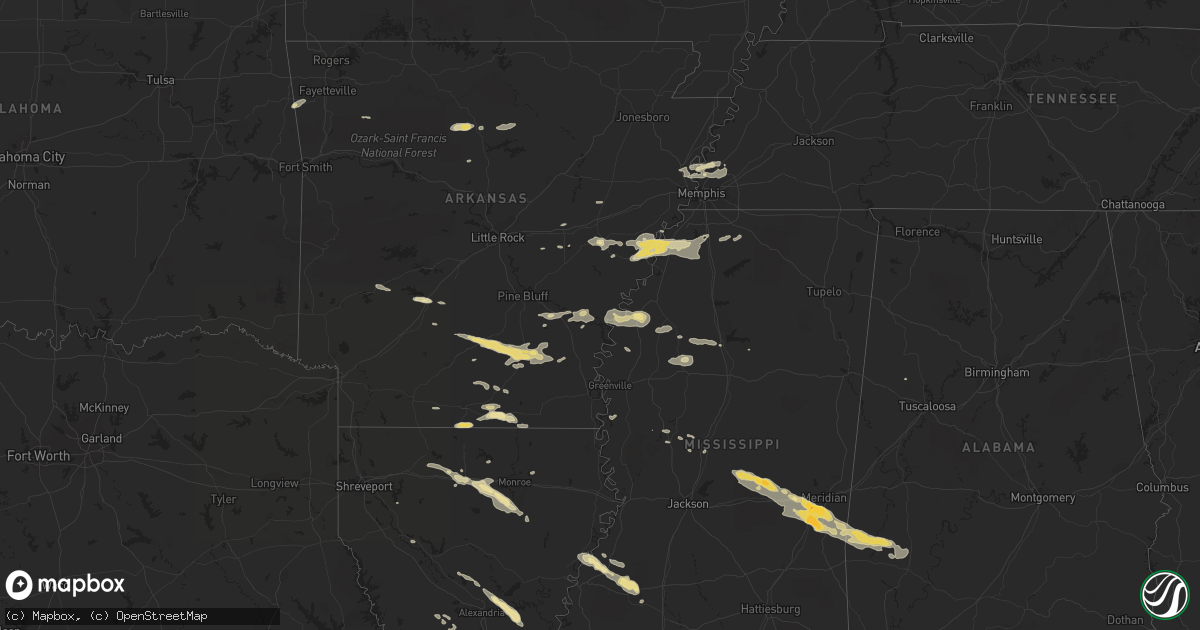
Hail Map in Arkansas on October 17, 2012
Get this storm
October 17 map
$229
one time, instant access
Download today. No call, no setup
Keep the $229
Bought the map and want the full workflow? Apply the entire $229 to a subscription within 7 days. None of it is wasted.
Every map, not just this one
This buys you this map. Subscription and you get every map we run, in the markets you choose from a few cities to whole states to nationwide. Plus real-time alerts the moment a storm fires.
Contact data
Name, contact info, occupancy, even credit band for addresses in the footprint. You go from where it hit to who to call.
Become the source they trust
Unlimited branding weather history reports on demand. You already have the documented answer ready for the property owner, and you are the one who showed up with it.
Property data and RoofTrace estimates
Pull up any address you have got, its value and the exact code rules for that jurisdiction, straight from One Click Code. Then RoofTrace estimates the squares, pitch, and roof value, priced the way you price.
Storm reports in Arkansas
Arkansas
| Date | Description |
|---|---|
| 10/16/20129:55 PM CDT | Power lines down in dermott. Many limbs down and a billboard torn apart. |
| 10/16/20129:50 PM CDT | Large limbs and power lines down throughout the city of monticello. |
| 10/16/20129:32 PM CDT | A couple trees down in lake chicot st park along hwy 257 |
| 10/16/20129:07 PM CDT | A few trees were down |
| 10/16/20128:47 PM CDT | A few trees were blown down |
| 10/16/20128:40 PM CDT | A local report indicates 1.00 inch wind near CADDO VALLEY |
| 10/16/20128:00 PM CDT | Trees down on county road 300 in hornor. |
| 10/16/20127:58 PM CDT | Several trees down across the city. |
| 10/16/20127:55 PM CDT | Tornado crossed interstate 55 near jericho exit. |
| 10/16/20127:45 PM CDT | Large tree reported down. |
| 10/16/20127:40 PM CDT | A building was damaged in clarendon...with parts of the building out in the street. Many trees and power lines were blown down. The entergy electic outage map indicated |
| 10/16/20127:37 PM CDT | Trees and powerlines down in clarendon. |
All States Impacted by Hail Map on October 17, 2012
Cities Impacted by Hail Map on October 17, 2012
- Warren, AR
- Thornton, AR
- Fordyce, AR
- New Edinburg, AR
- Junction City, AR
- Spearsville, LA
- El Dorado, AR
- Lillie, LA
- Arkadelphia, AR
- Bogalusa, LA
- Angie, LA
- Hermitage, AR
- Ruston, LA
- Grambling, LA
- Fayette, MS
- Natchez, MS
- Lorman, MS
- Waterproof, LA
- Leslie, AR
- Dennard, AR
- Marshall, AR
- Memphis, TN
- Munford, TN
- Drummonds, TN
- Millington, TN
- Clinton, AR
- Marksville, LA
- Effie, LA
- Deville, LA
- Pineville, LA
- Pollock, LA
- Center Point, LA
- Lexa, AR
- West Helena, AR
- Newton, MS
- Decatur, MS
- Gilbertown, AL
- Thomasville, AL
- Toxey, AL
- Needham, AL
- Butler, AL
- Campbell, AL
- Tunica, MS
- Schlater, MS
- Quitman, MS
- Enterprise, MS
- Stonewall, MS
- Yazoo City, MS
- Carlisle, AR
- Gould, AR
- Tichnor, AR
- Gillett, AR
- Amity, AR
- Glenwood, AR
- Gunnison, MS
- Alligator, MS
- Shelby, MS
- Duncan, MS
- Huttig, AR
- Strong, AR
- Simsboro, LA
- Arcadia, LA
- Elmer, LA
- Hineston, LA
- Grenada, MS
- Smithdale, MS
- Grady, AR
- Malvern, AR
- Donaldson, AR
- Boyce, LA
- Brinkley, AR
- Clarendon, AR
- Holly Grove, AR
- Wilmar, AR
- Marble Hill, MO
- Kountze, TX
- Dermott, AR
- Tillar, AR
- Coldwater, MS
- Poplar Grove, AR
- Marianna, AR
- Dundee, MS
- Tilly, AR
- Louise, MS
- Charleston, MS
- Pickens, MS
- Hermann, MO
- Lake Arthur, LA
- Jennings, LA
- Forest, MS
- Walnut Grove, MS
- Conehatta, MS
- Hampton, AR
- Reeves, LA
- Ragley, LA
- Philipp, MS
- Holcomb, MS
- Stockton, MO
- Hickory, MS
- Lena, MS
- Atoka, TN
- Benton, MS
- Ringgold, LA
- McCall Creek, MS
- Meadville, MS
- Roxie, MS
- Union Church, MS
- Rose Hill, MS
- Grove Hill, AL
- Lake, MS
- Louin, MS
- Lawrence, MS
- Coffeeville, AL
- Chunky, MS
- Meridian, MS
- Crossett, AR
- Hamburg, AR
- Eros, LA
- West Monroe, LA
- Glenmora, LA
- Greenwood, MS
- Banks, AR
- Kingsland, AR
- Monticello, AR
- Rison, AR
- Bearden, AR
- Sparkman, AR
- Columbia, LA
- Choudrant, LA
- Calhoun, LA
- Monroe, LA
- Byhalia, MS
- Collinston, LA
- Drew, MS
- Tutwiler, MS
- Parchman, MS
- Jackson, MO
- Cape Girardeau, MO
- Turrell, AR
- Marion, AR
- Crawfordsville, AR
- Arlington, TN
- Leesville, LA
- Saint Paul, AR
- Moreauville, LA
- Poplarville, MS
- Senatobia, MS
- Helena, AR
- Hernando, MS
- Sarah, MS
- Yorktown, AR
- Fox, AR
- Shirley, AR
- Mountain View, AR
- Edgemont, AR
- Ville Platte, LA
- Stuttgart, AR
- Hazen, AR
- Chatham, MS
- Hollandale, MS
- Saucier, MS
- Lincoln, AR
- Westville, OK
- Elkville, IL
- Dowell, IL
- Du Quoin, IL
- Bentley, LA
- Biscoe, AR
- Bernice, LA
- Dubach, LA
- Homer, LA
- Athens, LA
- Carthage, TX
- Downsville, LA
- Snow Lake, AR
- Mound Bayou, MS
- Clarksdale, MS
- Aubrey, AR
- Dry Prong, LA
- Star City, AR
- Coushatta, LA
- Center Ridge, AR
- Vaughan, MS
- Stilwell, OK
- Summers, AR
- Colfax, LA
- Atlanta, LA
- Perkinston, MS
- McHenry, MS
- Hunter, AR
- Cotton Plant, AR
- Watson, AR
- Cleveland, MS
- Fayette, AL
- Marvell, AR
- Brickeys, AR
- Jersey, AR
- Magnolia, AR
- Gore Springs, MS
- De Valls Bluff, AR


