Hail Map in North Carolina on October 11, 2026
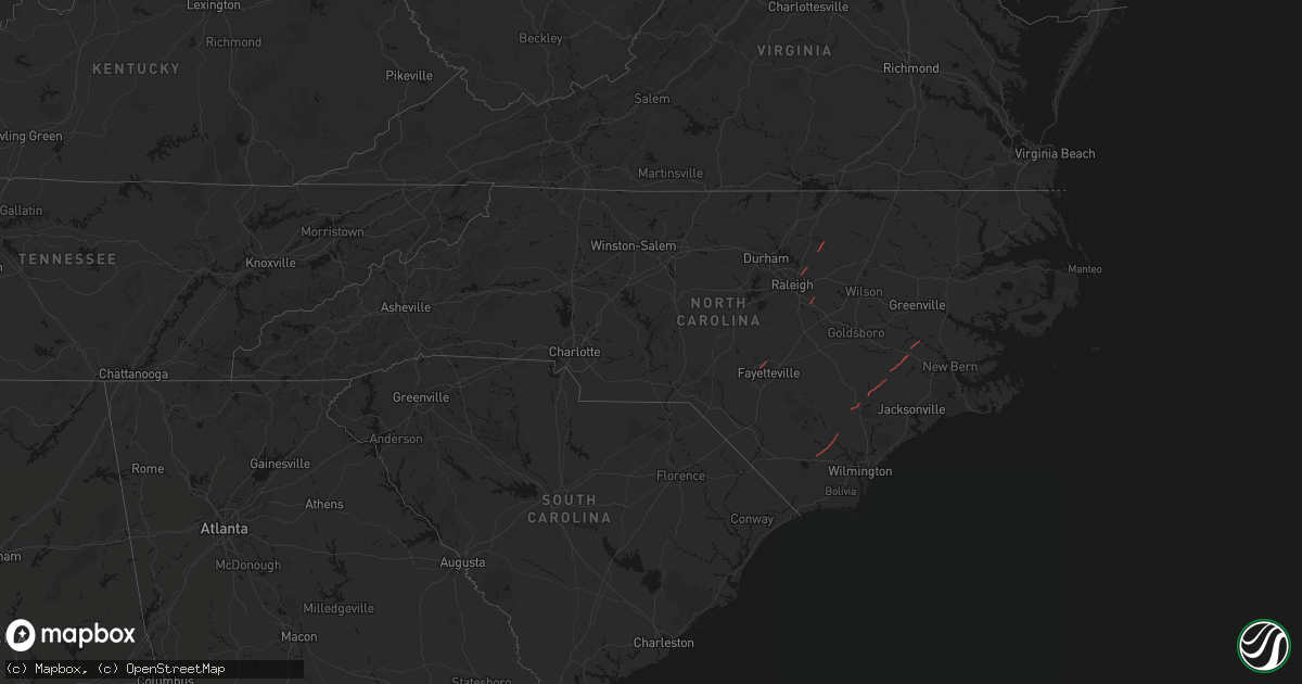
Get this storm
October 11 map
$229
one time, instant access
Download today. No call, no setup
Keep the $229
Bought the map and want the full workflow? Apply the entire $229 to a subscription within 7 days. None of it is wasted.
Every map, not just this one
This buys you this map. Subscription and you get every map we run, in the markets you choose from a few cities to whole states to nationwide. Plus real-time alerts the moment a storm fires.
Contact data
Name, contact info, occupancy, even credit band for addresses in the footprint. You go from where it hit to who to call.
Become the source they trust
Unlimited branding weather history reports on demand. You already have the documented answer ready for the property owner, and you are the one who showed up with it.
Property data and RoofTrace estimates
Pull up any address you have got, its value and the exact code rules for that jurisdiction, straight from One Click Code. Then RoofTrace estimates the squares, pitch, and roof value, priced the way you price.
Storm reports in North Carolina
North Carolina
| Date | Description |
|---|---|
| 10/11/20262:06 PM CDT | Trees snapped and blocking the road. Possible tornado damage. |
| 10/11/20261:48 PM CDT | Storm survey found evidence of an ef-1 tornado with estimated peak winds of 90 to 100 mph. The tornado was estimated to be 125 yards wide and 3.52 miles long. A debris |
| 10/11/20261:32 PM CDT | Report of trees down ne of beulaville. Possible tornado damage. |
| 10/11/202612:43 PM CDT | Tree on roadway on simms bridge rd. |
| 10/11/202612:43 PM CDT | Trees down due to possible tornado. |
| 10/11/202612:42 PM CDT | Approximate starting point of confirmed ef-1 tornado. A tornado touched down southwest of louisburg... Nc and moved to the northeast before crossing nc-56 just west of |
| 10/11/202612:40 PM CDT | A local report indicates a tornado near 6 W Bunn |
| 10/11/202612:40 PM CDT | Large tree down blocking all lanes. |
| 10/11/202612:38 PM CDT | Tree and debris blocking roadway. Road was closed due to damage. |
| 10/11/202612:38 PM CDT | Tree down on road blocking all lanes. Tornado damage possible. |
| 10/11/202612:38 PM CDT | Tree on road. Possible tornado damage. |
| 10/11/202612:38 PM CDT | Storm survey found evidence of an ef-2 tornado with estimated peak winds of 115 to 125 mph. The tornado was estimated to be 150 yards wide and 24.43 miles long. The tor |
| 10/11/202612:25 PM CDT | Nws storm survey confirmed a brief ef-0 tornado that crossed us421 between matthews rd and willard rd. Path length 0.18 miles... Width 30 yards. Time on ground approx 1 |
| 10/11/202612:22 PM CDT | Approximate end of tornado path. The tornado occurred along a 3.2 mile-long discontinuous path... As it momentarily touched down and lifted several times before finally |
| 10/11/202612:21 PM CDT | Powerlines down on hillsboro st. |
| 10/11/202612:18 PM CDT | Tornado sighted near rankin st and beattys bridge rd heading northeast toward hwy 421 and point caswell rd. |
| 10/11/202612:17 PM CDT | Tree on house... Tornado damage possible. |
| 10/11/202612:17 PM CDT | Tree on house. Possible tornado damage. |
| 10/11/202612:17 PM CDT | Approximate location of most intense damage. The tornado occurred along a 3.2 mile-long discontinuous path... As it momentarily touched down and lifted several times be |
| 10/11/202612:17 PM CDT | Trees down on tunas st / singleleaf ln tornado damage possible. |
| 10/11/202612:15 PM CDT | Approximate beginning of tornado path. The tornado occurred along a 3.2 mile-long discontinuous path... As it momentarily touched down and lifted several times before f |
| 10/11/202612:15 PM CDT | Tree damage on speight cir possible tornado damage. |
| 10/11/202612:12 PM CDT | Ef-1 tornado confirmed. Touched down in the stone ridge neighborhood... With a discontinuous path of tree and structural damage northward into the neuse crossing neighb |
| 10/11/202612:10 PM CDT | Tree down on house on amber bluffs cres... Possible tornado damage. |
| 10/11/202612:00 PM CDT | Tree down. |
| 10/11/202612:00 PM CDT | Trees down at exit 8 i440. Possible tornado damage. |
| 10/11/202612:00 PM CDT | Tree down on powerlines on merrywood dr. |
| 10/11/202612:00 PM CDT | Powerlines down on kennedy st. |
| 10/11/202611:58 AM CDT | Tree down on train tracks. |
| 10/11/202611:58 AM CDT | Tree on gate and partially on house. |
| 10/11/202611:55 AM CDT | Tree down at kennedy rd and e arcadia rd. Time estimated by radar. |
| 10/11/202611:55 AM CDT | Tree on powerlines. |
| 10/11/202611:51 AM CDT | Tree down on ridge rd. |
| 10/11/202611:32 AM CDT | A local report indicates a tornado near 1 E Carpenter |
| 10/11/202611:31 AM CDT | Tree on house on cass holt rd. |
| 10/11/202611:29 AM CDT | A short lived ef-1 tornado developed near the west regional library and traveled northeastward. Several trees were snapped in the library parking lot and in the adjacen |
| 10/11/202611:25 AM CDT | Possible tornado damage. |
| 10/11/202611:25 AM CDT | Trees down due to possible tornado. Also debris seen in this area. |
| 10/11/202611:25 AM CDT | Possible tornado damage. |
| 10/11/202611:25 AM CDT | Possible tornado damage. |
| 10/11/202611:25 AM CDT | Multiple reports of trees down and property damage around the ramsey street and linden intersection. Potential start of a tornado track. |
| 10/11/202611:23 AM CDT | The start of the linden... Nc tornado based on nws storm survey. Maximum winds of 105 mph |
| 10/11/202611:07 AM CDT | Public reported 4 structures destroyed on property with power outage and power line snapped. |
| 10/11/202611:05 AM CDT | Several trees are down along beaver creek rd... Both lanes of travel are blocked. |
| 10/11/202611:03 AM CDT | Numerous mature hardwood and pine trees downed... Snapped and twisted on beaver creek road... Just south of pea ridge road. Damage was coincident with a radar tds. |
| 10/11/202611:02 AM CDT | A short lived ef-1 tornado developed just south of beaver creek rd... Causing ef-1 damage as it crossed the road and moved northeastward. It eventually crossed a small |
| 10/11/202610:58 AM CDT | Several reports of storm damage including 18 wheeler flipped... Cars lifted and dropped... Roof damage... Power outages and trees down around the walmart and sams club |
| 10/11/202610:56 AM CDT | Multiple trees down in this vicinity of skibo road and morganton road. Suspected beginning of tornado track based on initial reports. |
| 10/11/202610:56 AM CDT | The start of the bonnie doone tornado path based on nws storm survey. Maximum winds of 115 mph |
| 10/11/202610:42 AM CDT | Large tree down on 2 power lines on gum springs church rd. |
| 10/11/202610:36 AM CDT | Trees down on powerlines along crawford dairy rd. |
| 10/11/20269:32 AM CDT | Lanier hill rd & lou cranford rd... Tree down blocking both lanes of travel. |
| 10/11/20269:30 AM CDT | Tree down and blocking both lanes of shamrock rd. |
| 10/11/20269:18 AM CDT | Tree blocking lane of travel on lassiter mill rd. |
| 10/11/20269:15 AM CDT | Approximate end of tornado path. A brief... But strong... Short-track tornado occurred on the northeast side of candor in between brutonville road and i-73. Drone image |
| 10/11/20269:15 AM CDT | Approximate location of most intense damage. A brief... But strong... Short-track tornado occurred on the northeast side of candor in between brutonville road and i-73. |
| 10/11/20269:14 AM CDT | Approximate beginning of tornado path. A brief... But strong... Short-track tornado occurred on the northeast side of candor in between brutonville road and i-73. Drone |
| 10/11/20269:14 AM CDT | Emergency manager reports one building destroyed and another severely damaged along with several large trees snapped in the hurricane drive and hillview street areas. |
| 10/11/20268:05 AM CDT | Tree and powerlines on helms road in peachland. |
| 10/11/20268:00 AM CDT | Debris-in-road |


