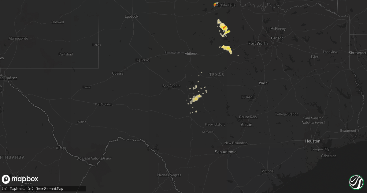
Hail Map in Texas on September 29, 2021
Get this storm
September 29 map
$229
one time, instant access
Download today. No call, no setup
Keep the $229
Bought the map and want the full workflow? Apply the entire $229 to a subscription within 7 days. None of it is wasted.
Every map, not just this one
This buys you this map. Subscription and you get every map we run, in the markets you choose from a few cities to whole states to nationwide. Plus real-time alerts the moment a storm fires.
Contact data
Name, contact info, occupancy, even credit band for addresses in the footprint. You go from where it hit to who to call.
Become the source they trust
Unlimited branding weather history reports on demand. You already have the documented answer ready for the property owner, and you are the one who showed up with it.
Property data and RoofTrace estimates
Pull up any address you have got, its value and the exact code rules for that jurisdiction, straight from One Click Code. Then RoofTrace estimates the squares, pitch, and roof value, priced the way you price.
Storm reports in Texas
Texas
| Date | Description |
|---|---|
| 09/29/20216:25 PM CDT | Trained spotter reported a measured 2.25 inch hail south of loving... Tx. |
| 09/29/20215:37 AM CDT | Asos station kbro brownsville. |
| 09/29/20213:10 AM CDT | At 810 PM CDT, a severe thunderstorm was located 11 miles east of Necessity, or 13 miles northeast of Ranger, and is nearly stationary. HAZARD...Ping pong ball size hail and 60 mph wind gusts. SOURCE...Radar indicated. IMPACT...People and animals outdoors will be injured. Expect hail damage to roofs, siding, windows, and vehicles. Expect wind damage to roofs, siding, and trees. Locations impacted include... Gordon, Strawn and Mingus. This includes Interstate 20 between mile markers 370 and 379. |
| 09/29/20211:52 AM CDT | At 651 PM CDT, a severe thunderstorm was located near Gordon, or 19 miles northeast of Ranger, moving east at 15 mph. HAZARD...60 mph wind gusts and half dollar size hail. SOURCE...Radar indicated. IMPACT...Hail damage to vehicles is expected. Expect wind damage to roofs, siding, and trees. Locations impacted include... Mineral Wells, Gordon and Mingus. This includes Interstate 20 between mile markers 371 and 389. |
| 09/29/20211:41 AM CDT | At 641 PM CDT, a severe thunderstorm was located over Bryson, or 11 miles east of Graham, moving northeast at 15 mph. HAZARD...60 mph wind gusts and half dollar size hail. SOURCE...Radar indicated. IMPACT...Hail damage to vehicles is expected. Expect wind damage to roofs, siding, and trees. Locations impacted include... Jacksboro and Bryson. |
| 09/29/20211:30 AM CDT | At 630 PM CDT, a severe thunderstorm was located over Brady Lake, moving east at 25 mph. HAZARD...60 mph wind gusts and quarter size hail. SOURCE...Radar indicated. IMPACT...Hail damage to vehicles is expected. Expect wind damage to roofs, siding, and trees. Locations impacted include... Brady, Brady Lake, Rochelle, Voca and Us-190 Near The Mcculloch- San Saba County Line. |
| 09/29/202112:58 AM CDT | At 556 PM CDT, a severe thunderstorm was located 10 miles north of Graham, moving southeast at 5 mph. Another storm southeast of Graham is also approaching severe limits, moving north along the eastern part of the county. HAZARD...60 mph wind gusts and quarter size hail. SOURCE...Radar indicated. IMPACT...Hail damage to vehicles is expected. Expect wind damage to roofs, siding, and trees. Locations impacted include... Graham and Newcastle. |
| 09/29/202112:38 AM CDT | At 537 PM CDT, a severe thunderstorm was located 5 miles west of Iowa Park, moving northeast at 5 mph. This storm will affect highway 287 between Iowa Park and Electra. HAZARD...Ping pong ball size hail and 60 mph wind gusts. SOURCE...Radar indicated. IMPACT...People and animals outdoors will be injured. Expect hail damage to roofs, siding, windows, and vehicles. Expect wind damage to roofs, siding, and trees. Locations impacted include... Iowa Park. |
| 09/29/202112:19 AM CDT | At 519 PM CDT, a severe thunderstorm was located 8 miles east of Olney, moving northeast at 10 mph. HAZARD...60 mph wind gusts and quarter size hail. SOURCE...Radar indicated. IMPACT...Hail damage to vehicles is expected. Expect wind damage to roofs, siding, and trees. This severe thunderstorm will remain over mainly rural areas of northeastern Young County. |
| 09/29/202112:11 AM CDT | At 510 AM CDT, a severe thunderstorm was located over Bayou Vista, or near Hitchcock, moving east at 30 mph. HAZARD...60 mph wind gusts. SOURCE...Radar indicated. IMPACT...Expect damage to roofs, siding, and trees. Locations impacted include... Galveston Island West End, Galveston Causeway, Texas City, La Marque, Hitchcock, Galveston Pier 21, Bayou Vista, Jamaica Beach, Tiki Island, Pelican Island, Galveston State Park, Schlitterbahn, Scholes Field, The Strand, Port Bolivar, Offatts Bayou, Galveston Pleasure Pier and Moody Gardens. |
| 09/29/202112:10 AM CDT | At 510 PM CDT, a severe thunderstorm was located 8 miles southwest of Grandfield, moving north at 25 mph. HAZARD...Quarter size hail. SOURCE...Radar indicated. IMPACT...Damage to vehicles is expected. Locations impacted include... Grandfield and Loveland. |
| 09/28/202111:39 PM CDT | At 439 PM CDT, a severe thunderstorm was located 8 miles south of Electra, moving north at 15 mph. HAZARD...Ping pong ball size hail and 60 mph wind gusts. SOURCE...Radar indicated. IMPACT...People and animals outdoors will be injured. Expect hail damage to roofs, siding, windows, and vehicles. Expect wind damage to roofs, siding, and trees. Locations impacted include... Electra and Haynesville. |
| 09/28/202111:22 PM CDT | At 422 AM CDT, severe thunderstorms were located along a line extending from Bush Intercontinental Airport to South Belt / Ellington, moving east at 25 mph. HAZARD...60 mph wind gusts. SOURCE...Radar indicated. IMPACT...Expect damage to roofs, siding, and trees. Locations impacted include... Pasadena, western Baytown, Deer Park, South Houston, Humble, Galena Park, Jacinto City, Cloverleaf, Downtown Houston, Northside / Northline, Second Ward, South Belt / Ellington, Highlands, Greater Eastwood, Near Northside Houston, Greater Fifth Ward, Aldine, Greater Hobby Area, Channelview and Greater Third Ward. |
| 09/28/202110:21 PM CDT | At 321 AM CDT, a severe thunderstorm was located 9 miles west of Kerr Wildlife Management Area, or 21 miles north of Vanderpool, moving east at 20 mph. HAZARD...60 mph wind gusts and quarter size hail. SOURCE...Radar indicated. IMPACT...Hail damage to vehicles is expected. Expect wind damage to roofs, siding, and trees. Locations impacted include... Ingram, Hunt, Mountain Home, Kerr Wildlife Management Area and Waltonia. |
All States Impacted by Hail Map on September 29, 2021
Cities Impacted by Hail Map on September 29, 2021
- Electra, TX
- Florence, AZ
- Herndon, KS
- Benson, AZ
- Hoxie, KS
- Graham, TX
- Loving, TX
- Olney, TX
- Gordon, TX
- Orient, SD
- Venango, NE
- Melvin, TX
- Mooreland, OK
- Ranger, TX
- Caddo, TX
- Strawn, TX
- Alva, OK
- Brady, TX
- Bloomfield, NM
- Iowa Park, TX
- Menard, TX
- Protection, KS
- Ashland, KS
- Tucson, AZ
- Elsie, NE
- Wallace, NE
- Grandfield, OK
- Bryson, TX
- Millersview, TX
- Eden, TX
- Pueblo, CO
- Stephenville, TX
- Mingus, TX
- Palo Pinto, TX
- Goodland, KS
- Casa Grande, AZ
- Coldwater, KS
- Holliday, TX
- Sells, AZ
- McDonald, KS
- Medicine Lodge, KS
- Lake City, KS
- London, TX
- Minneola, KS
- Trinidad, CO
- Jansen, NE
- Glade, KS
- Phillipsburg, KS
- Aguilar, CO
- Ogallala, NE
- Keystone, NE
- Ulysses, KS
- Freedom, OK
- Plevna, KS
- Sterling, KS
- Edson, KS
- Lemoyne, NE
- Arthur, NE
- San Manuel, AZ
- Kearny, AZ
- Rochelle, TX
- Spearville, KS
- Leola, SD
- Ericson, NE
- Mankato, KS
- Newcastle, TX
- Jacksboro, TX
- Sylvia, KS
- Wetmore, CO
- Stockton, KS
- Davidson, OK
- Doole, TX
- Gouldbusk, TX
- Madrid, NE
- Grant, NE
- Kensal, ND
- Hill City, KS
- Coleman, TX
- Burlington, OK
- Bluff Dale, TX
- Webber, KS
- Wallace, KS
- Sharon Springs, KS
- McCook, NE
- Culbertson, NE
- Cleo Springs, OK
- Show Low, AZ
- Ringwood, OK
- Aline, OK
- Sperry, OK
- Tulsa, OK
- Skiatook, OK
- Garden City, KS
- Meno, OK
- Loveland, OK
- Breckenridge, TX
- Cherokee, OK
- Ingalls, KS
- Copeland, KS
- Bucklin, KS
- Pratt, KS
- Turon, KS
- Lohn, TX
- Sedona, AZ
- Helena, OK
- Richland Springs, TX
- Lahoma, OK


