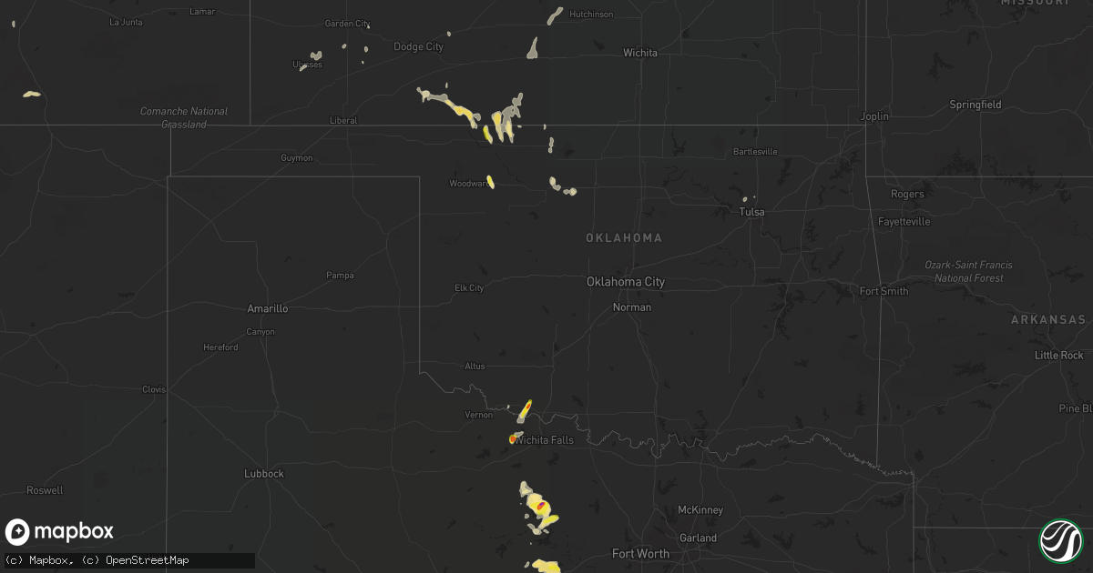
Hail Map in Oklahoma on September 29, 2021
Get this storm
September 29 map
$229
one time, instant access
Download today. No call, no setup
Keep the $229
Bought the map and want the full workflow? Apply the entire $229 to a subscription within 7 days. None of it is wasted.
Every map, not just this one
This buys you this map. Subscription and you get every map we run, in the markets you choose from a few cities to whole states to nationwide. Plus real-time alerts the moment a storm fires.
Contact data
Name, contact info, occupancy, even credit band for addresses in the footprint. You go from where it hit to who to call.
Become the source they trust
Unlimited branding weather history reports on demand. You already have the documented answer ready for the property owner, and you are the one who showed up with it.
Property data and RoofTrace estimates
Pull up any address you have got, its value and the exact code rules for that jurisdiction, straight from One Click Code. Then RoofTrace estimates the squares, pitch, and roof value, priced the way you price.
Storm reports in Oklahoma
Oklahoma
| Date | Description |
|---|---|
| 09/29/20216:30 PM CDT | Report 4n of curtis... Photos forwarded by broadcast media. |
| 09/29/20215:38 PM CDT | Report from mping. |
| 09/29/20215:35 PM CDT | Reported quarter to golfball sized hail. |
| 09/29/20211:13 AM CDT | At 613 PM CDT, a severe thunderstorm was located 4 miles east of Mooreland, moving north at 15 mph. HAZARD...Ping pong ball size hail and 60 mph wind gusts. SOURCE...Radar indicated. IMPACT...People and animals outdoors will be injured. Expect hail damage to roofs, siding, windows, and vehicles. Expect wind damage to roofs, siding, and trees. Locations impacted include... Mooreland, Quinlan and Alabaster Caverns State Park. |
| 09/28/20217:55 PM CDT | A local report indicates 61 MPH wind near 13 NNE CAMP HOUSTON |
All States Impacted by Hail Map on September 29, 2021
Cities Impacted by Hail Map on September 29, 2021
- Electra, TX
- Florence, AZ
- Herndon, KS
- Benson, AZ
- Hoxie, KS
- Graham, TX
- Loving, TX
- Olney, TX
- Gordon, TX
- Orient, SD
- Venango, NE
- Melvin, TX
- Mooreland, OK
- Ranger, TX
- Caddo, TX
- Strawn, TX
- Alva, OK
- Brady, TX
- Bloomfield, NM
- Iowa Park, TX
- Menard, TX
- Protection, KS
- Ashland, KS
- Tucson, AZ
- Elsie, NE
- Wallace, NE
- Grandfield, OK
- Bryson, TX
- Millersview, TX
- Eden, TX
- Pueblo, CO
- Stephenville, TX
- Mingus, TX
- Palo Pinto, TX
- Goodland, KS
- Casa Grande, AZ
- Coldwater, KS
- Holliday, TX
- Sells, AZ
- McDonald, KS
- Medicine Lodge, KS
- Lake City, KS
- London, TX
- Minneola, KS
- Trinidad, CO
- Jansen, NE
- Glade, KS
- Phillipsburg, KS
- Aguilar, CO
- Ogallala, NE
- Keystone, NE
- Ulysses, KS
- Freedom, OK
- Plevna, KS
- Sterling, KS
- Edson, KS
- Lemoyne, NE
- Arthur, NE
- San Manuel, AZ
- Kearny, AZ
- Rochelle, TX
- Spearville, KS
- Leola, SD
- Ericson, NE
- Mankato, KS
- Newcastle, TX
- Jacksboro, TX
- Sylvia, KS
- Wetmore, CO
- Stockton, KS
- Davidson, OK
- Doole, TX
- Gouldbusk, TX
- Madrid, NE
- Grant, NE
- Kensal, ND
- Hill City, KS
- Coleman, TX
- Burlington, OK
- Bluff Dale, TX
- Webber, KS
- Wallace, KS
- Sharon Springs, KS
- McCook, NE
- Culbertson, NE
- Cleo Springs, OK
- Show Low, AZ
- Ringwood, OK
- Aline, OK
- Sperry, OK
- Tulsa, OK
- Skiatook, OK
- Garden City, KS
- Meno, OK
- Loveland, OK
- Breckenridge, TX
- Cherokee, OK
- Ingalls, KS
- Copeland, KS
- Bucklin, KS
- Pratt, KS
- Turon, KS
- Lohn, TX
- Sedona, AZ
- Helena, OK
- Richland Springs, TX
- Lahoma, OK


