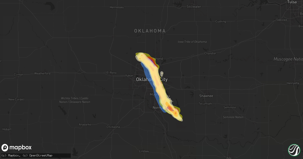
Hail Map in Oklahoma City, OK on September 24, 2024
Get this storm
September 24 map
$229
one time, instant access
Download today. No call, no setup
Keep the $229
Bought the map and want the full workflow? Apply the entire $229 to a subscription within 7 days. None of it is wasted.
Every map, not just this one
This buys you this map. Subscription and you get every map we run, in the markets you choose from a few cities to whole states to nationwide. Plus real-time alerts the moment a storm fires.
Contact data
Name, contact info, occupancy, even credit band for addresses in the footprint. You go from where it hit to who to call.
Become the source they trust
Unlimited branding weather history reports on demand. You already have the documented answer ready for the property owner, and you are the one who showed up with it.
Property data and RoofTrace estimates
Pull up any address you have got, its value and the exact code rules for that jurisdiction, straight from One Click Code. Then RoofTrace estimates the squares, pitch, and roof value, priced the way you price.
Storm reports in Oklahoma City, OK
Oklahoma City, OK
| Date | Description |
|---|---|
| 09/24/20246:55 PM CDT | Report from mping: quarter |
| 09/24/20246:55 PM CDT | Caliper measurement near se 89th and bryant. |
| 09/24/20246:45 PM CDT | Delayed report. Social media image. Radar estimated time. |
| 09/24/20246:45 PM CDT | Near interstate 240 and sunnylane road. |
| 09/24/20246:45 PM CDT | Near i-240 and sooner road. Measured 2.25 inch stone after the hail stopped but larger when falling. |
| 09/24/20246:40 PM CDT | Delayed report. Social media image with ruler measurement. |
| 09/24/20246:30 PM CDT | Larger than golf ball size hail near i-44 and mlk. |
| 09/24/20246:26 PM CDT | Intermittent golf ball size hail between 6:26 pm and 6:38 pm near ne 50th and mlk. |
| 09/24/20246:17 PM CDT | Report from mping: ping pong ball |
| 09/24/20246:17 PM CDT | Nw 122nd and penn. |
| 09/24/20246:15 PM CDT | Near interstate 235 and wilshire from research meteorologist. |
| 09/24/20246:13 PM CDT | Report from mping: golf ball |
| 09/24/20246:12 PM CDT | Report from mping: half dollar |
| 09/24/20246:10 PM CDT | Larger than golf ball size hail southwest of memorial and western. |
| 09/24/20246:09 PM CDT | Near nw 150th and penn. Breaking car windows. |
| 09/24/20246:08 PM CDT | Measured 2.33 inch hail near nw 122nd and penn. |
| 09/24/20246:05 PM CDT | Just northeast of quail springs mall. |
| 09/24/20246:02 PM CDT | Report from mping: quarter |
All States Impacted by Hail Map on September 24, 2024
All Cities Impacted by Hail Map on September 24, 2024
- Hopkinsville, KY
- Gracey, KY
- Dunmor, KY
- Lewisburg, KY
- Morgantown, KY
- Sonora, KY
- Upton, KY
- Hodgenville, KY
- Buffalo, KY
- Magnolia, KY
- Battletown, KY
- Corydon, IN
- New Haven, KY
- Campbellsville, KY
- New Hope, KY
- McEwen, TN
- Linn, WV
- Alum Bridge, WV
- Saint Francis, KY
- Loretto, KY
- Lebanon, KY
- Springfield, KY
- Raywick, KY
- Georgetown, IN
- Lanesville, IN
- Camden, WV
- Jane Lew, WV
- Weston, WV
- Swiss, WV
- Saint Catharine, KY
- Vanleer, TN
- Dickson, TN
- New Albany, IN
- Floyds Knobs, IN
- Lost Creek, WV
- Franklin, KY
- Harrodsburg, KY
- Mackville, KY
- Cumberland Furnace, TN
- Summersville, WV
- Charlestown, IN
- Clarksville, IN
- Sellersburg, IN
- Jeffersonville, IN
- Goshen, KY
- Mount Clare, WV
- Portland, TN
- Crestwood, KY
- Clarksville, TN
- Cunningham, TN
- Southside, TN
- Prospect, KY
- La Grange, KY
- Westport, KY
- Pendleton, KY
- Woodburn, KY
- Chapmansboro, TN
- Ashland City, TN
- White Bluff, TN
- Scottsville, KY
- Turners Station, KY
- Campbellsburg, KY
- Sulphur, KY
- Water Valley, MS
- New Castle, KY
- Greensburg, KY
- Charlotte, TN
- Springfield, TN
- Pleasant View, TN
- Cub Run, KY
- Munfordville, KY
- New Liberty, KY
- Owenton, KY
- Worthville, KY
- Perry Park, KY
- Orlinda, TN
- Greenbrier, TN
- Glasgow, KY
- Lucas, KY
- Clinton, SC
- Laurens, SC
- Cross Plains, TN
- Burns, TN
- Adolphus, KY
- Westmoreland, TN
- Clarkson, KY
- Corning, IA
- Banner, MS
- Bruce, MS
- Pembroke, VA
- Bonnieville, KY
- White House, TN
- Goodlettsville, TN
- Cottontown, TN
- Hendersonville, TN
- Kingston Springs, TN
- Randolph, MS
- Coffeeville, MS
- Gainesville, GA
- Dawsonville, GA
- Fountain Run, KY
- Williamstown, KY
- Dry Ridge, KY
- Eighty Eight, KY
- Summer Shade, KY
- Gallatin, TN
- Austin, KY
- Jonesville, KY
- Newport, VA
- Bethpage, TN
- Fort Davis, TX
- Tompkinsville, KY
- Etoile, KY
- Franklin, TN
- Nashville, TN
- Mount Pleasant, TN
- Murrayville, GA
- Houlka, MS
- Prescott, IA
- North Tazewell, VA
- Tazewell, VA
- Cedar Bluff, VA
- Bandy, VA
- Pounding Mill, VA
- Columbia, KY
- Ripplemead, VA
- Brentwood, TN
- Mount Hermon, KY
- Salem, WV
- Clarksburg, WV
- Gradyville, KY
- Walkersville, WV
- Hartsville, TN
- Narrows, VA
- Pleasureville, KY
- Bagdad, KY
- Mount Juliet, TN
- Nodaway, IA
- Lafayette, TN
- Lebanon, TN
- Sanders, KY
- Lula, GA
- Pontotoc, MS
- Taylorsville, KY
- Mount Washington, KY
- Mannsville, KY
- Columbia, TN
- Hermitage, TN
- Stanford, KY
- Antioch, TN
- Ligonier, IN
- Wawaka, IN
- Frankfort, KY
- Lockport, KY
- Clarinda, IA
- Red Boiling Springs, TN
- Bedford, IA
- New Market, IA
- Eggleston, VA
- Pearisburg, VA
- Crawfordville, GA
- Glencoe, KY
- Haviland, OH
- Eaton, OH
- West Alexandria, OH
- Amory, MS
- Okolona, MS
- Aberdeen, MS
- Nettleton, MS
- Smithville, MS
- Burkesville, KY
- Braddyville, IA
- Corinth, KY
- Sadieville, KY
- Stamping Ground, KY
- Cynthiana, KY
- Berry, KY
- Paulding, OH
- Rockholds, KY
- Williamsburg, KY
- Albany, KY
- Blacksburg, VA
- Hopkins, MO
- Clearmont, MO
- Fulton, MS
- Greenwood Springs, MS
- Tremont, MS
- Payne, OH
- Scott, OH
- Convoy, OH
- Monroeville, IN
- Woodbine, KY
- Corbin, KY
- Wolcottville, IN
- Lagrange, IN
- Alpha, KY
- Sheridan, MO
- Monticello, KY
- Carthage, TN
- Elmwood, TN
- Pleasant Shade, TN
- Gainesboro, TN
- Whitleyville, TN
- Granville, TN
- Brush Creek, TN
- Pickering, MO
- Burlington Junction, MO
- Maryville, MO
- Gold Hill, NC
- Salisbury, NC
- Gaffney, SC
- Marathon, TX
- Van Wert, OH
- Purmela, TX
- Rockwell, NC
- Gray, KY
- Richfield, NC
- Jamestown, KY
- Russell Springs, KY
- Watertown, TN
- London, KY
- Oakwood, OH
- Barbourville, KY
- Lily, KY
- Breeding, KY
- Ravenwood, MO
- Denton, NC
- Bronston, KY
- Allons, TN
- Hilham, TN
- Livingston, TN
- Cookeville, TN
- Rickman, TN
- Burnside, KY
- Manchester, KY
- Parkers Lake, KY
- Whitley City, KY
- Monroe, TN
- Alpine, TN
- Grover Hill, OH
- Tazewell, TN
- Harrogate, TN
- Cloverdale, OH
- Sneedville, TN
- Jonesville, VA
- Skidmore, MO
- Graham, MO
- Carey, OH
- Continental, OH
- Holgate, OH
- Coila, MS
- Vaiden, MS
- West, MS
- Byrdstown, TN
- Tyner, KY
- Winona, MS
- Alvada, OH
- Kyles Ford, TN
- Jamestown, TN
- Barnard, MO
- Murphy, NC
- Milton, KY
- Bedford, KY
- Troy, NC
- Keavy, KY
- Bolckow, MO
- Fillmore, MO
- Breckenridge, TX
- Piedmont, OK
- Edmond, OK
- Creston, IA
- Kilmichael, MS
- Tiffin, OH
- New Riegel, OH
- Elk Horn, KY
- Albemarle, NC
- Madison, IN
- Lorena, TX
- Blackwater, VA
- Moody, TX
- Kelly, LA
- Grayson, LA
- Columbia, LA
- Olla, LA
- Moran, TX
- Savannah, MO
- Rosendale, MO
- Topeka, KS
- Auburn, KS
- Oklahoma City, OK
- McGregor, TX
- McKee, KY
- Joelton, TN
- Duck Hill, MS
- Vincent, KY
- Wakarusa, KS
- Scranton, KS
- Carbondale, KS
- Cisco, TX
- Republic, OH
- Stewart, MS
- Stearns, KY
- Lovelady, TX
- North Fairfield, OH
- Eupora, MS
- Trinity, TX
- Erin, TN
- Gore Springs, MS
- Weber City, VA
- Gate City, VA
- Kingsport, TN
- Church Hill, TN
- Mount Carmel, TN
- Nacogdoches, TX
- San Augustine, TX
- Gower, MO
- Amazonia, MO
- Plattsburg, MO
- Spencer, OK
- Jones, OK
- Custar, OH
- Wakeman, OH
- Collins, OH
- Badin, NC
- Bethel Springs, TN
- Lathrop, MO
- Bellevue, OH
- Norman, OK
- Normangee, TX
- Huntsville, TX
- Hiltons, VA
- Milano, TX
- Caldwell, TX
- Bowling Green, KY
- Rockfield, KY
- Onalaska, TX
- Greenville, SC
- Piedmont, SC
- Chandler, OK
- Livingston, TX
- Mountain Rest, SC
- Noble, OK
- Meeker, OK
- Sparks, OK
- Tamassee, SC
- Roundhill, KY
- Salem, SC
- Prague, OK
- Shawnee, OK
- Vaughan, MS
- Brownsville, KY
- Kansas City, MO
- Liberty, MO
- Pickens, MS
- Benton, MS
- Fort Blackmore, VA
- Lexington, OK
- Conroe, TX
- Pegram, TN
- Blountville, TN
- Sunset, SC
- Earlsboro, OK
- Willis, TX
- Depew, OK
- Bristow, OK
- Mannford, OK
- Stroud, OK
- Seminole, OK
- Paden, OK
- Kellyville, OK
- Vicksburg, MS
- Independence, MO
- Pickens, SC
- Castle, OK
- Okemah, OK
- Wewoka, OK
- Yale, OK
- Maramec, OK
- Glencoe, OK
- Stillwater, OK
- Pawnee, OK
- Greenwood, MO
- Pleasant Hill, MO
- Lees Summit, MO
- Lone Jack, MO
- Morris, OK
- Okmulgee, OK
- Brenham, TX
- Industry, TX
- Shelby, NC
- Boley, OK
- Blacksburg, SC
- Council Hill, OK
- Henryetta, OK
- Grover, NC
- Weleetka, OK
- Ripley, OK
- Cushing, OK
- Kings Mountain, NC
- Eldorado, TX
- Checotah, OK
- Davenport, OK
- Eufaula, OK
- Maud, OK
- Bowlegs, OK
- Holdenville, OK
- Wetumka, OK
- Six Mile, SC
- Sasakwa, OK
- Holliday, TX
- Sulphur, OK
- Roff, OK
- Mcloud, OK
- Tecumseh, OK
- Mill Creek, OK
- Mannsville, OK
- Madill, OK
- Ardmore, OK
- Ewing, VA
- Rose Hill, VA
- Lebanon, OK
- Marietta, OK
- Gordonville, TX
- Sadler, TX
- Whitesboro, TX
- Sherman, TX
- Pottsboro, TX
- Howe, TX
- Collinsville, TX
- Tioga, TX
- Pilot Point, TX
- Gunter, TX
- Celina, TX
- Prosper, TX
- Aubrey, TX
- Little Elm, TX
- Frisco, TX
- Morton, MS
- Pelahatchie, MS
- The Colony, TX
- Plano, TX
- Carrollton, TX
- Dallas, TX
- Boynton, OK
- Addison, TX
- Coppell, TX
- Irving, TX
- Somerset, KY
- Haughton, LA
- Chillicothe, OH
- Bainbridge, OH
- Waverly, OH
- Lorman, MS
- Union Church, MS
- Rockbridge, OH
- Laurelville, OH
- Eidson, TN


