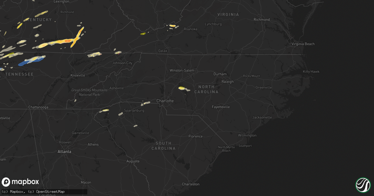
Hail Map in North Carolina on September 24, 2024
Get this storm
September 24 map
$229
one time, instant access
Download today. No call, no setup
Keep the $229
Bought the map and want the full workflow? Apply the entire $229 to a subscription within 7 days. None of it is wasted.
Every map, not just this one
This buys you this map. Subscription and you get every map we run, in the markets you choose from a few cities to whole states to nationwide. Plus real-time alerts the moment a storm fires.
Contact data
Name, contact info, occupancy, even credit band for addresses in the footprint. You go from where it hit to who to call.
Become the source they trust
Unlimited branding weather history reports on demand. You already have the documented answer ready for the property owner, and you are the one who showed up with it.
Property data and RoofTrace estimates
Pull up any address you have got, its value and the exact code rules for that jurisdiction, straight from One Click Code. Then RoofTrace estimates the squares, pitch, and roof value, priced the way you price.
Storm reports in North Carolina
North Carolina
| Date | Description |
|---|---|
| 09/24/20246:35 PM CDT | Tree down with power lines near the intersection of riverside drive and jackson road in surry county north carolina. |
| 09/24/20245:42 PM CDT | Corrects previous tstm wnd dmg report from 4 wnw seagrove. Trees down at nc highway 134 and burney rd. |
| 09/24/20245:27 PM CDT | Corrects previous tstm wnd dmg report from 2 n flat rock. Tree down with power lines near the intersection of riverside drive and jackson road in surry county north car |
| 09/24/20245:22 PM CDT | Corrects previous tstm wnd dmg report from 2 n toast. Downed tree blocking both lanes on galax trail near twelve oaks nursing home. |
| 09/24/20245:08 PM CDT | Trees down at nc highway 49 s and salem church rd. |
| 09/24/20244:36 PM CDT | Powerlines and trees down in the 13000 block of bringle ferry road. |
| 09/24/20244:33 PM CDT | Trees down near the intersection of panther creek road and stokes ferry road. |
| 09/24/20241:07 PM CDT | A report of a tree down on new stock road. |
| 09/24/202412:01 AM CDT | Downed tree blocking both lanes on galax trail near twelve oaks nursing home. |
| 09/23/202411:25 PM CDT | Several trees either down or split off halfway up in the backyards of 2 adjacent properties on the south side of mocksville. |
All States Impacted by Hail Map on September 24, 2024
Cities Impacted by Hail Map on September 24, 2024
- Hopkinsville, KY
- Gracey, KY
- Dunmor, KY
- Lewisburg, KY
- Morgantown, KY
- Sonora, KY
- Upton, KY
- Hodgenville, KY
- Buffalo, KY
- Magnolia, KY
- Battletown, KY
- Corydon, IN
- New Haven, KY
- Campbellsville, KY
- New Hope, KY
- McEwen, TN
- Linn, WV
- Alum Bridge, WV
- Saint Francis, KY
- Loretto, KY
- Lebanon, KY
- Springfield, KY
- Raywick, KY
- Georgetown, IN
- Lanesville, IN
- Camden, WV
- Jane Lew, WV
- Weston, WV
- Swiss, WV
- Saint Catharine, KY
- Vanleer, TN
- Dickson, TN
- New Albany, IN
- Floyds Knobs, IN
- Lost Creek, WV
- Franklin, KY
- Harrodsburg, KY
- Mackville, KY
- Cumberland Furnace, TN
- Summersville, WV
- Charlestown, IN
- Clarksville, IN
- Sellersburg, IN
- Jeffersonville, IN
- Goshen, KY
- Mount Clare, WV
- Portland, TN
- Crestwood, KY
- Clarksville, TN
- Cunningham, TN
- Southside, TN
- Prospect, KY
- La Grange, KY
- Westport, KY
- Pendleton, KY
- Woodburn, KY
- Chapmansboro, TN
- Ashland City, TN
- White Bluff, TN
- Scottsville, KY
- Turners Station, KY
- Campbellsburg, KY
- Sulphur, KY
- Water Valley, MS
- New Castle, KY
- Greensburg, KY
- Charlotte, TN
- Springfield, TN
- Pleasant View, TN
- Cub Run, KY
- Munfordville, KY
- New Liberty, KY
- Owenton, KY
- Worthville, KY
- Perry Park, KY
- Orlinda, TN
- Greenbrier, TN
- Glasgow, KY
- Lucas, KY
- Clinton, SC
- Laurens, SC
- Cross Plains, TN
- Burns, TN
- Adolphus, KY
- Westmoreland, TN
- Clarkson, KY
- Corning, IA
- Banner, MS
- Bruce, MS
- Pembroke, VA
- Bonnieville, KY
- White House, TN
- Goodlettsville, TN
- Cottontown, TN
- Hendersonville, TN
- Kingston Springs, TN
- Randolph, MS
- Coffeeville, MS
- Gainesville, GA
- Dawsonville, GA
- Fountain Run, KY
- Williamstown, KY
- Dry Ridge, KY
- Eighty Eight, KY
- Summer Shade, KY
- Gallatin, TN
- Austin, KY
- Jonesville, KY
- Newport, VA
- Bethpage, TN
- Fort Davis, TX
- Tompkinsville, KY
- Etoile, KY
- Franklin, TN
- Nashville, TN
- Mount Pleasant, TN
- Murrayville, GA
- Houlka, MS
- Prescott, IA
- North Tazewell, VA
- Tazewell, VA
- Cedar Bluff, VA
- Bandy, VA
- Pounding Mill, VA
- Columbia, KY
- Ripplemead, VA
- Brentwood, TN
- Mount Hermon, KY
- Salem, WV
- Clarksburg, WV
- Gradyville, KY
- Walkersville, WV
- Hartsville, TN
- Narrows, VA
- Pleasureville, KY
- Bagdad, KY
- Mount Juliet, TN
- Nodaway, IA
- Lafayette, TN
- Lebanon, TN
- Sanders, KY
- Lula, GA
- Pontotoc, MS
- Taylorsville, KY
- Mount Washington, KY
- Mannsville, KY
- Columbia, TN
- Hermitage, TN
- Stanford, KY
- Antioch, TN
- Ligonier, IN
- Wawaka, IN
- Frankfort, KY
- Lockport, KY
- Clarinda, IA
- Red Boiling Springs, TN
- Bedford, IA
- New Market, IA
- Eggleston, VA
- Pearisburg, VA
- Crawfordville, GA
- Glencoe, KY
- Haviland, OH
- Eaton, OH
- West Alexandria, OH
- Amory, MS
- Okolona, MS
- Aberdeen, MS
- Nettleton, MS
- Smithville, MS
- Burkesville, KY
- Braddyville, IA
- Corinth, KY
- Sadieville, KY
- Stamping Ground, KY
- Cynthiana, KY
- Berry, KY
- Paulding, OH
- Rockholds, KY
- Williamsburg, KY
- Albany, KY
- Blacksburg, VA
- Hopkins, MO
- Clearmont, MO
- Fulton, MS
- Greenwood Springs, MS
- Tremont, MS
- Payne, OH
- Scott, OH
- Convoy, OH
- Monroeville, IN
- Woodbine, KY
- Corbin, KY
- Wolcottville, IN
- Lagrange, IN
- Alpha, KY
- Sheridan, MO
- Monticello, KY
- Carthage, TN
- Elmwood, TN
- Pleasant Shade, TN
- Gainesboro, TN
- Whitleyville, TN
- Granville, TN
- Brush Creek, TN
- Pickering, MO
- Burlington Junction, MO
- Maryville, MO
- Gold Hill, NC
- Salisbury, NC
- Gaffney, SC
- Marathon, TX
- Van Wert, OH
- Purmela, TX
- Rockwell, NC
- Gray, KY
- Richfield, NC
- Jamestown, KY
- Russell Springs, KY
- Watertown, TN
- London, KY
- Oakwood, OH
- Barbourville, KY
- Lily, KY
- Breeding, KY
- Ravenwood, MO
- Denton, NC
- Bronston, KY
- Allons, TN
- Hilham, TN
- Livingston, TN
- Cookeville, TN
- Rickman, TN
- Burnside, KY
- Manchester, KY
- Parkers Lake, KY
- Whitley City, KY
- Monroe, TN
- Alpine, TN
- Grover Hill, OH
- Tazewell, TN
- Harrogate, TN
- Cloverdale, OH
- Sneedville, TN
- Jonesville, VA
- Skidmore, MO
- Graham, MO
- Carey, OH
- Continental, OH
- Holgate, OH
- Coila, MS
- Vaiden, MS
- West, MS
- Byrdstown, TN
- Tyner, KY
- Winona, MS
- Alvada, OH
- Kyles Ford, TN
- Jamestown, TN
- Barnard, MO
- Murphy, NC
- Milton, KY
- Bedford, KY
- Troy, NC
- Keavy, KY
- Bolckow, MO
- Fillmore, MO
- Breckenridge, TX
- Piedmont, OK
- Edmond, OK
- Creston, IA
- Kilmichael, MS
- Tiffin, OH
- New Riegel, OH
- Elk Horn, KY
- Albemarle, NC
- Madison, IN
- Lorena, TX
- Blackwater, VA
- Moody, TX
- Kelly, LA
- Grayson, LA
- Columbia, LA
- Olla, LA
- Moran, TX
- Savannah, MO
- Rosendale, MO
- Topeka, KS
- Auburn, KS
- Oklahoma City, OK
- McGregor, TX
- McKee, KY
- Joelton, TN
- Duck Hill, MS
- Vincent, KY
- Wakarusa, KS
- Scranton, KS
- Carbondale, KS
- Cisco, TX
- Republic, OH
- Stewart, MS
- Stearns, KY
- Lovelady, TX
- North Fairfield, OH
- Eupora, MS
- Trinity, TX
- Erin, TN
- Gore Springs, MS
- Weber City, VA
- Gate City, VA
- Kingsport, TN
- Church Hill, TN
- Mount Carmel, TN
- Nacogdoches, TX
- San Augustine, TX
- Gower, MO
- Amazonia, MO
- Plattsburg, MO
- Spencer, OK
- Jones, OK
- Custar, OH
- Wakeman, OH
- Collins, OH
- Badin, NC
- Bethel Springs, TN
- Lathrop, MO
- Bellevue, OH
- Norman, OK
- Normangee, TX
- Huntsville, TX
- Hiltons, VA
- Milano, TX
- Caldwell, TX
- Bowling Green, KY
- Rockfield, KY
- Onalaska, TX
- Greenville, SC
- Piedmont, SC
- Chandler, OK
- Livingston, TX
- Mountain Rest, SC
- Noble, OK
- Meeker, OK
- Sparks, OK
- Tamassee, SC
- Roundhill, KY
- Salem, SC
- Prague, OK
- Shawnee, OK
- Vaughan, MS
- Brownsville, KY
- Kansas City, MO
- Liberty, MO
- Pickens, MS
- Benton, MS
- Fort Blackmore, VA
- Lexington, OK
- Conroe, TX
- Pegram, TN
- Blountville, TN
- Sunset, SC
- Earlsboro, OK
- Willis, TX
- Depew, OK
- Bristow, OK
- Mannford, OK
- Stroud, OK
- Seminole, OK
- Paden, OK
- Kellyville, OK
- Vicksburg, MS
- Independence, MO
- Pickens, SC
- Castle, OK
- Okemah, OK
- Wewoka, OK
- Yale, OK
- Maramec, OK
- Glencoe, OK
- Stillwater, OK
- Pawnee, OK
- Greenwood, MO
- Pleasant Hill, MO
- Lees Summit, MO
- Lone Jack, MO
- Morris, OK
- Okmulgee, OK
- Brenham, TX
- Industry, TX
- Shelby, NC
- Boley, OK
- Blacksburg, SC
- Council Hill, OK
- Henryetta, OK
- Grover, NC
- Weleetka, OK
- Ripley, OK
- Cushing, OK
- Kings Mountain, NC
- Eldorado, TX
- Checotah, OK
- Davenport, OK
- Eufaula, OK
- Maud, OK
- Bowlegs, OK
- Holdenville, OK
- Wetumka, OK
- Six Mile, SC
- Sasakwa, OK
- Holliday, TX
- Sulphur, OK
- Roff, OK
- Mcloud, OK
- Tecumseh, OK
- Mill Creek, OK
- Mannsville, OK
- Madill, OK
- Ardmore, OK
- Ewing, VA
- Rose Hill, VA
- Lebanon, OK
- Marietta, OK
- Gordonville, TX
- Sadler, TX
- Whitesboro, TX
- Sherman, TX
- Pottsboro, TX
- Howe, TX
- Collinsville, TX
- Tioga, TX
- Pilot Point, TX
- Gunter, TX
- Celina, TX
- Prosper, TX
- Aubrey, TX
- Little Elm, TX
- Frisco, TX
- Morton, MS
- Pelahatchie, MS
- The Colony, TX
- Plano, TX
- Carrollton, TX
- Dallas, TX
- Boynton, OK
- Addison, TX
- Coppell, TX
- Irving, TX
- Somerset, KY
- Haughton, LA
- Chillicothe, OH
- Bainbridge, OH
- Waverly, OH
- Lorman, MS
- Union Church, MS
- Rockbridge, OH
- Laurelville, OH
- Eidson, TN


