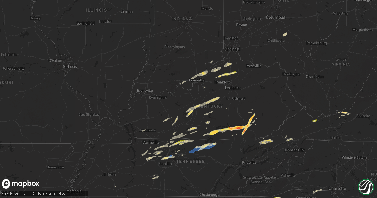
Hail Map in Kentucky on September 24, 2024
Get this storm
September 24 map
$229
one time, instant access
Download today. No call, no setup
Keep the $229
Bought the map and want the full workflow? Apply the entire $229 to a subscription within 7 days. None of it is wasted.
Every map, not just this one
This buys you this map. Subscription and you get every map we run, in the markets you choose from a few cities to whole states to nationwide. Plus real-time alerts the moment a storm fires.
Contact data
Name, contact info, occupancy, even credit band for addresses in the footprint. You go from where it hit to who to call.
Become the source they trust
Unlimited branding weather history reports on demand. You already have the documented answer ready for the property owner, and you are the one who showed up with it.
Property data and RoofTrace estimates
Pull up any address you have got, its value and the exact code rules for that jurisdiction, straight from One Click Code. Then RoofTrace estimates the squares, pitch, and roof value, priced the way you price.
Storm reports in Kentucky
Kentucky
| Date | Description |
|---|---|
| 09/24/20246:10 PM CDT | Hail fell along ky 11 near the clay county border and was estimated to be between quarter and golf ball sized. |
| 09/24/20245:50 PM CDT | A local report indicates 1.75 inch wind near Gray |
| 09/24/20245:40 PM CDT | Video on social media of quarter-sized hail falling behind the kfc in north corbin. Time estimated via radar. |
| 09/24/20245:36 PM CDT | A tree was blown down onto lower wolfe creek road about 7 miles from the outskirts of booneville or between eddie marshall ln and ky 2024. The event time is radar estim |
| 09/24/20245:36 PM CDT | A picture of hail was received from southwest of corbin along cumberland falls hwy. The event time is radar estimated. |
| 09/24/20245:31 PM CDT | Social media report of trees down on power lines and a broken power pole. Time estimated via radar. |
| 09/24/20245:30 PM CDT | A public report with a picture was relayed by an amateur radio operator in the bee creek community southeast of bark camp. The event time is radar estimated. |
| 09/24/20245:28 PM CDT | A picture was received of at least 3 inch diameter hail from the bee creek community along ky 1193 in the vicinity of bark camp. The event time is radar estimated. |
| 09/24/20245:12 PM CDT | A picture was received via social media of hail of at least egg size near burning springs. |
| 09/24/20245:12 PM CDT | Photo on social media of golf ball sized hail in alpine. |
| 09/24/20245:11 PM CDT | A social media report with a picture was relayed by broadcast media of hail of 2 to 2.25 inches in diameter. |
| 09/24/20245:11 PM CDT | Picture on social media of about 2 inch wide hailstones along laurel heights road. Time estimated via radar |
| 09/24/20245:05 PM CDT | Social media picture of estimated 1.5 inch hail in fogertown |
| 09/24/20245:00 PM CDT | A tree was blown down near the intersection of us 27 and jeru knob road. |
| 09/24/20244:55 PM CDT | Jackson county dispatch reported a tree blown down across mccammon ridge road near the intersection with kim gay lane. Event time estimated from radar. |
| 09/24/20244:45 PM CDT | A public social media reported of quarter sized hail relayed by amateur radio. |
| 09/24/20244:31 PM CDT | Rockcastle county 911 center reported a tree down at the intersection of us 25 and upper calloway loop. Time estimated from radar. |
| 09/24/20244:25 PM CDT | Rockcastle county 911 center reported a down tree at the intersection of marler hollow rd and sand springs rd. Time estimated from radar. |
| 09/24/20244:25 PM CDT | Social media post of a snapped power pole along sam parker road in knox county. Time estimated via radar. Approximately |
| 09/24/20244:25 PM CDT | A local report indicates 1.75 inch wind near Cumberland City |
| 09/24/20244:22 PM CDT | Wayne county dispatch reported a tree blown down onto ky-834 west approximately a mile north of the intersection with ky-90. |
| 09/24/20244:20 PM CDT | Trees and powerlines were down in the spruce pine and saylor communities of southwestern leslie county or in the general vicinity of the intersection of ky 1780 and ky |
| 09/24/20244:20 PM CDT | Pictures on social media show snapped power pole beside a home near the intersection of hollen dale drive and ky-6. Time estimated from radar. |
| 09/24/20244:19 PM CDT | Half dollar sized hail reported near cumberland city. |
| 09/24/20244:15 PM CDT | Picture of a large uprooted tree on social media across from wilton pond along highway 6. Time estimated via radar. |
| 09/24/20244:14 PM CDT | Ham radio operator reports 2 inch estimated hail in rockholds... With a picture included. |
| 09/24/20243:00 PM CDT | A few large limbs and trees down in stanford. |
| 09/24/20242:58 PM CDT | Ongoing at report time. |
| 09/24/20242:36 PM CDT | A few trees down in hodgenville. |
| 09/24/20242:31 PM CDT | Trees down. Time estimated from radar. |
| 09/24/20242:10 PM CDT | Trees down near old glasgow road. |
| 09/24/20242:06 PM CDT | A few trees down in downtown scottsville. |
| 09/24/20241:55 PM CDT | Corrects previous tstm wnd dmg report time from 1 ese austin. Tree down on austin tracy road. |
| 09/24/20241:55 PM CDT | Few trees down near barren river lake. |
| 09/24/20241:53 PM CDT | Tree down on austin tracy road. |
| 09/24/20241:52 PM CDT | Few trees down within the city limits of campbellsville. |
| 09/24/20241:50 PM CDT | Trees down on jw york road. |
| 09/24/20241:46 PM CDT | Tree down. Time estimated from radar. |
| 09/24/20241:41 PM CDT | Multiple trees and power lines down. Time estimated from radar. |
| 09/24/20241:20 PM CDT | Large tree limbs and a tree down near maple avenue. |
| 09/24/20241:17 PM CDT | Tree damage and power lines down. |
| 09/24/202412:54 PM CDT | Tree on house at this location. |
| 09/24/202412:53 PM CDT | A few trees down in river bluff. |
| 09/24/202412:32 PM CDT | A few large limbs and trees down in idle hour park. Structural damage to baseball field. |
| 09/24/202412:30 PM CDT | Corrects previous tstm wnd dmg report with updated time from springfield. Tree damage and power lines down. |
| 09/24/202411:56 AM CDT | Power pole wires damaged. |
| 09/24/202411:53 AM CDT | 2 trees down on greensburg road. |
| 09/24/202411:33 AM CDT | Several large branches down across brackett cemetery road. |
| 09/24/20247:55 AM CDT | Uprooted tree at this location. |
All States Impacted by Hail Map on September 24, 2024
Cities Impacted by Hail Map on September 24, 2024
- Hopkinsville, KY
- Gracey, KY
- Dunmor, KY
- Lewisburg, KY
- Morgantown, KY
- Sonora, KY
- Upton, KY
- Hodgenville, KY
- Buffalo, KY
- Magnolia, KY
- Battletown, KY
- Corydon, IN
- New Haven, KY
- Campbellsville, KY
- New Hope, KY
- McEwen, TN
- Linn, WV
- Alum Bridge, WV
- Saint Francis, KY
- Loretto, KY
- Lebanon, KY
- Springfield, KY
- Raywick, KY
- Georgetown, IN
- Lanesville, IN
- Camden, WV
- Jane Lew, WV
- Weston, WV
- Swiss, WV
- Saint Catharine, KY
- Vanleer, TN
- Dickson, TN
- New Albany, IN
- Floyds Knobs, IN
- Lost Creek, WV
- Franklin, KY
- Harrodsburg, KY
- Mackville, KY
- Cumberland Furnace, TN
- Summersville, WV
- Charlestown, IN
- Clarksville, IN
- Sellersburg, IN
- Jeffersonville, IN
- Goshen, KY
- Mount Clare, WV
- Portland, TN
- Crestwood, KY
- Clarksville, TN
- Cunningham, TN
- Southside, TN
- Prospect, KY
- La Grange, KY
- Westport, KY
- Pendleton, KY
- Woodburn, KY
- Chapmansboro, TN
- Ashland City, TN
- White Bluff, TN
- Scottsville, KY
- Turners Station, KY
- Campbellsburg, KY
- Sulphur, KY
- Water Valley, MS
- New Castle, KY
- Greensburg, KY
- Charlotte, TN
- Springfield, TN
- Pleasant View, TN
- Cub Run, KY
- Munfordville, KY
- New Liberty, KY
- Owenton, KY
- Worthville, KY
- Perry Park, KY
- Orlinda, TN
- Greenbrier, TN
- Glasgow, KY
- Lucas, KY
- Clinton, SC
- Laurens, SC
- Cross Plains, TN
- Burns, TN
- Adolphus, KY
- Westmoreland, TN
- Clarkson, KY
- Corning, IA
- Banner, MS
- Bruce, MS
- Pembroke, VA
- Bonnieville, KY
- White House, TN
- Goodlettsville, TN
- Cottontown, TN
- Hendersonville, TN
- Kingston Springs, TN
- Randolph, MS
- Coffeeville, MS
- Gainesville, GA
- Dawsonville, GA
- Fountain Run, KY
- Williamstown, KY
- Dry Ridge, KY
- Eighty Eight, KY
- Summer Shade, KY
- Gallatin, TN
- Austin, KY
- Jonesville, KY
- Newport, VA
- Bethpage, TN
- Fort Davis, TX
- Tompkinsville, KY
- Etoile, KY
- Franklin, TN
- Nashville, TN
- Mount Pleasant, TN
- Murrayville, GA
- Houlka, MS
- Prescott, IA
- North Tazewell, VA
- Tazewell, VA
- Cedar Bluff, VA
- Bandy, VA
- Pounding Mill, VA
- Columbia, KY
- Ripplemead, VA
- Brentwood, TN
- Mount Hermon, KY
- Salem, WV
- Clarksburg, WV
- Gradyville, KY
- Walkersville, WV
- Hartsville, TN
- Narrows, VA
- Pleasureville, KY
- Bagdad, KY
- Mount Juliet, TN
- Nodaway, IA
- Lafayette, TN
- Lebanon, TN
- Sanders, KY
- Lula, GA
- Pontotoc, MS
- Taylorsville, KY
- Mount Washington, KY
- Mannsville, KY
- Columbia, TN
- Hermitage, TN
- Stanford, KY
- Antioch, TN
- Ligonier, IN
- Wawaka, IN
- Frankfort, KY
- Lockport, KY
- Clarinda, IA
- Red Boiling Springs, TN
- Bedford, IA
- New Market, IA
- Eggleston, VA
- Pearisburg, VA
- Crawfordville, GA
- Glencoe, KY
- Haviland, OH
- Eaton, OH
- West Alexandria, OH
- Amory, MS
- Okolona, MS
- Aberdeen, MS
- Nettleton, MS
- Smithville, MS
- Burkesville, KY
- Braddyville, IA
- Corinth, KY
- Sadieville, KY
- Stamping Ground, KY
- Cynthiana, KY
- Berry, KY
- Paulding, OH
- Rockholds, KY
- Williamsburg, KY
- Albany, KY
- Blacksburg, VA
- Hopkins, MO
- Clearmont, MO
- Fulton, MS
- Greenwood Springs, MS
- Tremont, MS
- Payne, OH
- Scott, OH
- Convoy, OH
- Monroeville, IN
- Woodbine, KY
- Corbin, KY
- Wolcottville, IN
- Lagrange, IN
- Alpha, KY
- Sheridan, MO
- Monticello, KY
- Carthage, TN
- Elmwood, TN
- Pleasant Shade, TN
- Gainesboro, TN
- Whitleyville, TN
- Granville, TN
- Brush Creek, TN
- Pickering, MO
- Burlington Junction, MO
- Maryville, MO
- Gold Hill, NC
- Salisbury, NC
- Gaffney, SC
- Marathon, TX
- Van Wert, OH
- Purmela, TX
- Rockwell, NC
- Gray, KY
- Richfield, NC
- Jamestown, KY
- Russell Springs, KY
- Watertown, TN
- London, KY
- Oakwood, OH
- Barbourville, KY
- Lily, KY
- Breeding, KY
- Ravenwood, MO
- Denton, NC
- Bronston, KY
- Allons, TN
- Hilham, TN
- Livingston, TN
- Cookeville, TN
- Rickman, TN
- Burnside, KY
- Manchester, KY
- Parkers Lake, KY
- Whitley City, KY
- Monroe, TN
- Alpine, TN
- Grover Hill, OH
- Tazewell, TN
- Harrogate, TN
- Cloverdale, OH
- Sneedville, TN
- Jonesville, VA
- Skidmore, MO
- Graham, MO
- Carey, OH
- Continental, OH
- Holgate, OH
- Coila, MS
- Vaiden, MS
- West, MS
- Byrdstown, TN
- Tyner, KY
- Winona, MS
- Alvada, OH
- Kyles Ford, TN
- Jamestown, TN
- Barnard, MO
- Murphy, NC
- Milton, KY
- Bedford, KY
- Troy, NC
- Keavy, KY
- Bolckow, MO
- Fillmore, MO
- Breckenridge, TX
- Piedmont, OK
- Edmond, OK
- Creston, IA
- Kilmichael, MS
- Tiffin, OH
- New Riegel, OH
- Elk Horn, KY
- Albemarle, NC
- Madison, IN
- Lorena, TX
- Blackwater, VA
- Moody, TX
- Kelly, LA
- Grayson, LA
- Columbia, LA
- Olla, LA
- Moran, TX
- Savannah, MO
- Rosendale, MO
- Topeka, KS
- Auburn, KS
- Oklahoma City, OK
- McGregor, TX
- McKee, KY
- Joelton, TN
- Duck Hill, MS
- Vincent, KY
- Wakarusa, KS
- Scranton, KS
- Carbondale, KS
- Cisco, TX
- Republic, OH
- Stewart, MS
- Stearns, KY
- Lovelady, TX
- North Fairfield, OH
- Eupora, MS
- Trinity, TX
- Erin, TN
- Gore Springs, MS
- Weber City, VA
- Gate City, VA
- Kingsport, TN
- Church Hill, TN
- Mount Carmel, TN
- Nacogdoches, TX
- San Augustine, TX
- Gower, MO
- Amazonia, MO
- Plattsburg, MO
- Spencer, OK
- Jones, OK
- Custar, OH
- Wakeman, OH
- Collins, OH
- Badin, NC
- Bethel Springs, TN
- Lathrop, MO
- Bellevue, OH
- Norman, OK
- Normangee, TX
- Huntsville, TX
- Hiltons, VA
- Milano, TX
- Caldwell, TX
- Bowling Green, KY
- Rockfield, KY
- Onalaska, TX
- Greenville, SC
- Piedmont, SC
- Chandler, OK
- Livingston, TX
- Mountain Rest, SC
- Noble, OK
- Meeker, OK
- Sparks, OK
- Tamassee, SC
- Roundhill, KY
- Salem, SC
- Prague, OK
- Shawnee, OK
- Vaughan, MS
- Brownsville, KY
- Kansas City, MO
- Liberty, MO
- Pickens, MS
- Benton, MS
- Fort Blackmore, VA
- Lexington, OK
- Conroe, TX
- Pegram, TN
- Blountville, TN
- Sunset, SC
- Earlsboro, OK
- Willis, TX
- Depew, OK
- Bristow, OK
- Mannford, OK
- Stroud, OK
- Seminole, OK
- Paden, OK
- Kellyville, OK
- Vicksburg, MS
- Independence, MO
- Pickens, SC
- Castle, OK
- Okemah, OK
- Wewoka, OK
- Yale, OK
- Maramec, OK
- Glencoe, OK
- Stillwater, OK
- Pawnee, OK
- Greenwood, MO
- Pleasant Hill, MO
- Lees Summit, MO
- Lone Jack, MO
- Morris, OK
- Okmulgee, OK
- Brenham, TX
- Industry, TX
- Shelby, NC
- Boley, OK
- Blacksburg, SC
- Council Hill, OK
- Henryetta, OK
- Grover, NC
- Weleetka, OK
- Ripley, OK
- Cushing, OK
- Kings Mountain, NC
- Eldorado, TX
- Checotah, OK
- Davenport, OK
- Eufaula, OK
- Maud, OK
- Bowlegs, OK
- Holdenville, OK
- Wetumka, OK
- Six Mile, SC
- Sasakwa, OK
- Holliday, TX
- Sulphur, OK
- Roff, OK
- Mcloud, OK
- Tecumseh, OK
- Mill Creek, OK
- Mannsville, OK
- Madill, OK
- Ardmore, OK
- Ewing, VA
- Rose Hill, VA
- Lebanon, OK
- Marietta, OK
- Gordonville, TX
- Sadler, TX
- Whitesboro, TX
- Sherman, TX
- Pottsboro, TX
- Howe, TX
- Collinsville, TX
- Tioga, TX
- Pilot Point, TX
- Gunter, TX
- Celina, TX
- Prosper, TX
- Aubrey, TX
- Little Elm, TX
- Frisco, TX
- Morton, MS
- Pelahatchie, MS
- The Colony, TX
- Plano, TX
- Carrollton, TX
- Dallas, TX
- Boynton, OK
- Addison, TX
- Coppell, TX
- Irving, TX
- Somerset, KY
- Haughton, LA
- Chillicothe, OH
- Bainbridge, OH
- Waverly, OH
- Lorman, MS
- Union Church, MS
- Rockbridge, OH
- Laurelville, OH
- Eidson, TN


