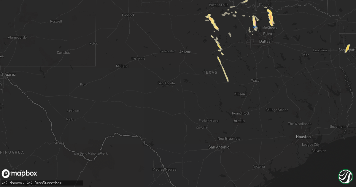
Hail Map in Texas on September 21, 2025
Get this storm
September 21 map
$229
one time, instant access
Download today. No call, no setup
Keep the $229
Bought the map and want the full workflow? Apply the entire $229 to a subscription within 7 days. None of it is wasted.
Every map, not just this one
This buys you this map. Subscription and you get every map we run, in the markets you choose from a few cities to whole states to nationwide. Plus real-time alerts the moment a storm fires.
Contact data
Name, contact info, occupancy, even credit band for addresses in the footprint. You go from where it hit to who to call.
Become the source they trust
Unlimited branding weather history reports on demand. You already have the documented answer ready for the property owner, and you are the one who showed up with it.
Property data and RoofTrace estimates
Pull up any address you have got, its value and the exact code rules for that jurisdiction, straight from One Click Code. Then RoofTrace estimates the squares, pitch, and roof value, priced the way you price.
Storm reports in Texas
Texas
| Date | Description |
|---|---|
| 09/21/20256:35 PM CDT | 68 mph gust measured at twu. |
| 09/21/20256:34 PM CDT | Report from mping. |
| 09/21/20256:25 PM CDT | Report from mping: hen egg |
| 09/21/20256:23 PM CDT | Report from mping. |
| 09/21/20256:17 PM CDT | Report from mping: half dollar |
| 09/21/20256:16 PM CDT | Report from mping: golf ball |
| 09/21/20256:16 PM CDT | A local report indicates 1.75 inch wind near Van Alstyne |
| 09/21/20256:13 PM CDT | Report from mping: ping pong ball |
| 09/21/20256:05 PM CDT | Report from mping. |
| 09/21/20256:05 PM CDT | 60 mph gust measured by the denton airport awos. |
| 09/21/20256:02 PM CDT | 64.2 mph gust measured at hwy 288 and i-35. |
| 09/21/20256:02 PM CDT | 64.2 mph gust measured at hwy |
| 09/21/20256:01 PM CDT | Photos received of multiple trees snapped and branches down just east of desdemona. |
| 09/21/20255:57 PM CDT | Report from mping. |
| 09/21/20255:52 PM CDT | Social media photo and video of large tree uprooted... Approximately 2 feet in diameter. |
| 09/21/20255:51 PM CDT | Large hail 2.25-2.5 inches in size fell for 8-10 minutes about 3 miles southeast of howe. Windows were broken and roof damage was observed. The weather station at this |
| 09/21/20255:51 PM CDT | A weather station approximately 3 miles southeast of howe measured a 62 mph wind gust. Large tree branches were also broken. |
| 09/21/20255:50 PM CDT | Power lines down at bennett rd and fm 902 just east-northeast of howe. |
| 09/21/20255:45 PM CDT | Photo received of measured 1.75 inch hail. Time estimated. |
| 09/21/20255:39 PM CDT | Report from mping. |
| 09/21/20255:35 PM CDT | In addition to hail also reported a blown over chicken coop. |
| 09/21/20255:35 PM CDT | Social media video of a semi trailer blown over onto two other vehicles on i35 near sanger. Exact location unknown. |
| 09/21/20255:35 PM CDT | Report from mping: ping pong ball |
| 09/21/20255:33 PM CDT | Broken tree limbs and power poles were reported on belz road north of sanger. |
| 09/21/20255:32 PM CDT | Partial wall collapse at a walmart distribution center. Time estimated. |
| 09/21/20255:32 PM CDT | Multiple overturned campers at the sanger koa on i35 near view road. Time estimated. |
| 09/21/20255:31 PM CDT | A local report indicates 1.00 inch wind near 1 E Sanger |
| 09/21/20255:30 PM CDT | Report from mping. |
| 09/21/20255:30 PM CDT | Photo received of measured 2.5 inch hail. Time estimated. |
| 09/21/20255:23 PM CDT | A local report indicates 1.25 inch wind near 2 SSE Knollwood |
| 09/21/20255:21 PM CDT | Report from mping. |
| 09/21/20255:03 PM CDT | Kgyi. |
| 09/21/20254:35 PM CDT | Scattered downed trees and sheet metal removed from buildings throughout olney. Wooden power poles leaning. |
| 09/21/20255:30 AM CDT | An analysis of tree damage in and around the roanoke area suggests winds up to 60 mph broke many large tree limbs. |
| 09/21/20253:49 AM CDT | A 72 mph wind gust was measured in ponder. Large tree damage was reported southeast of fm 156 and fm 2449... Along with minor roof damage. Large tree limbs were broken. |
| 09/20/20259:59 PM CDT | A local report indicates 61 MPH wind near Evant |
| 09/20/20259:26 PM CDT | Kmnz. |
| 09/20/20257:50 PM CDT | Front |
| 09/20/20257:50 PM CDT | Front entrance of a building collapsed inward with glass blown out of the front windows in mingus. |
| 09/20/20257:33 PM CDT | A mobile home lost its roof and outbuildings were knocked down on cr 347... Located southeast of proctor. |
All States Impacted by Hail Map on September 21, 2025
Cities Impacted by Hail Map on September 21, 2025
- Jamestown, TN
- Oneida, TN
- Pall Mall, TN
- Quincy, MO
- Weaubleau, MO
- Milford, OH
- Cincinnati, OH
- Loveland, OH
- Goshen, OH
- Wheatland, MO
- Pleasant Plain, OH
- Blanchester, OH
- Morrow, OH
- Williamsburg, KY
- Spencer, TN
- Ponce De Leon, FL
- Calhoun, KY
- Only, TN
- Morris, OK
- Boynton, OK
- Freeport, FL
- Duncan, OK
- Haskell, OK
- Defuniak Springs, FL
- Council Hill, OK
- Oktaha, OK
- Muskogee, OK
- Taft, OK
- Porter, OK
- Lewisport, KY
- Philpot, KY
- Westport, TN
- Holladay, TN
- Hawesville, KY
- Buena Vista, TN
- Wildersville, TN
- Yuma, TN
- Ardmore, OK
- Le Roy, IL
- Monee, IL
- Checotah, OK
- Lone Grove, OK
- Tell City, IN
- Cannelton, IN
- Morris, IL
- Warner, OK
- Seymour, TX
- Slater, MO
- Alligator, MS
- Wendell, ID
- Louisa, KY
- Miami, MO
- Marshall, MO
- Holliday, TX
- Derby, IN
- Mchenry, IL
- Woodstock, IL
- Frankfort, IL
- Coal City, IL
- Channahon, IL
- Wilmington, IL
- Lenoir City, TN
- Clarksdale, MS
- Leopold, IN
- Lexington, TN
- Porum, OK
- Gilliam, MO
- Crystal Lake, IL
- Henderson, TN
- Olney, TX
- Harriman, TN
- Madill, OK
- Webbers Falls, OK
- Parsons, TN
- Island Lake, IL
- Elwood, IL
- Round Lake, IL
- Wauconda, IL
- Ingleside, IL
- Grayslake, IL
- Fox Lake, IL
- Flat Rock, AL
- Mazon, IL
- Gardner, IL
- Matteson, IL
- Manhattan, IL
- Henrietta, TX
- Braceville, IL
- Park Valley, UT
- Mapleton, MN
- Good Thunder, MN
- Bowie, TX
- Nocona, TX
- Gainesville, TX
- Stigler, OK
- Bellevue, TX
- Garden City, MN
- Sulphur, OK
- Keota, OK
- Grouse Creek, UT
- Pemberton, MN
- Valley View, TX
- Lake Crystal, MN
- Era, TX
- Denison, TX
- Pottsboro, TX
- Sherman, TX
- Snowville, UT
- Malta, ID
- Eufaula, OK
- Saint Jo, TX
- Forestburg, TX
- Newcastle, TX
- Graham, TX
- Loving, TX
- Janesville, MN
- Sanger, TX
- Ringgold, TX
- Waseca, MN
- Murfreesboro, TN
- Flandreau, SD
- Mankato, MN
- Centerville, MO
- Quinton, OK
- Kinta, OK
- Vian, OK
- Sallisaw, OK
- Howe, TX
- Aubrey, TX
- Denton, TX
- Van Alstyne, TX
- Whitewright, TX
- Tom Bean, TX
- Whitefield, OK
- Waldorf, MN
- New Richland, MN
- Pipestone, MN
- Black, MO
- Anna, TX
- Ellendale, MN
- Owatonna, MN
- Belleview, MO
- New London, MO
- Niles, MI
- Spiro, OK
- Krum, TX
- Muldrow, OK
- Gans, OK
- Versailles, IL
- Kinderhook, IL
- Wilson, OK
- Ringling, OK
- Dowagiac, MI
- Barry, IL
- Dublin, TX
- Desdemona, TX
- Melissa, TX
- Edgerton, MN
- Waynesboro, MS
- Trent, SD
- Jasper, MN
- Perrin, TX
- Shreveport, LA
- De Leon, TX
- Breckenridge, TX
- South Bend, TX
- Mckinney, TX
- Blue Ridge, TX
- Blooming Prairie, MN
- Decatur, MI
- Alcester, SD
- Bossier City, LA
- Argyle, TX
- Whitt, TX
- Waterville, MN
- Hudson, SD
- Braidwood, IL
- Montgomery, MN
- Madison Lake, MN
- Cleveland, MN
- Elysian, MN
- Lawton, MI
- Paw Paw, MI
- Graford, TX
- Strawn, TX
- Mineral Wells, TX
- Mattawan, MI
- Barksdale Afb, LA
- Franklin, IL
- Alexander, IL
- Waverly, IL
- Webster, MN
- Elko New Market, MN
- Lonsdale, MN
- Caddo, TX
- New Prague, MN
- Benton, LA
- Lewisville, TX
- Moore, ID
- Mannsville, OK
- Hardwick, MN
- Loami, IL
- Richland, MI
- Luverne, MN
- Kenneth, MN
- Worthington, MN
- Rock Valley, IA
- Hawarden, IA
- Saint Paul Park, MN
- Hastings, MN
- Cottage Grove, MN
- Rochester, IL
- Morristown, MN
- Saint Paul, MN
- Inver Grove Heights, MN
- South Saint Paul, MN
- Okabena, MN
- Brewster, MN
- Mingus, TX
- Eureka, NV
- Rosemount, MN
- River Falls, WI
- Gordon, TX
- Sioux Center, IA
- Newport, MN
- Lakefield, MN
- Round Lake, MN
- Montrose, MN
- Delano, MN
- Blackfoot, ID
- Ocheyedan, IA
- Gustine, TX
- Ranger, TX
- Ireton, IA
- Burnsville, MN
- Magnolia, MN
- Adrian, MN
- Afton, MN
- Lake Elmo, MN
- Cosmos, MN
- Windom, MN
- Maurice, IA
- Carlton, TX
- Roland, OK
- Lakeland, MN
- Stillwater, MN
- Hudson, WI
- Maple Plain, MN
- Jackson, MN
- Bingham Lake, MN
- Stephenville, TX
- Litchfield, MN
- Hamilton, TX
- Mound, MN
- Long Lake, MN
- Wayzata, MN
- Hutchinson, MN
- Downs, IL
- Le Mars, IA
- Trimont, MN
- Odin, MN
- Fort Smith, AR
- Mountain Lake, MN
- Spring Park, MN
- Arkoma, OK
- Pocola, OK
- Excelsior, MN
- Minnetonka, MN
- Hopkins, MN
- New Richmond, WI
- Saint James, MN
- Ormsby, MN
- University Park, IL
- Crete, IL
- Park Forest, IL
- Chicago Heights, IL
- Steger, IL
- Thornton, IL
- Homewood, IL
- Hazel Crest, IL
- Glenwood, IL
- Butterfield, MN
- Minneapolis, MN
- Richton Park, IL
- Barling, AR
- Heron Lake, MN
- Eden Prairie, MN
- Evant, TX
- Van Buren, AR
- Chanhassen, MN
- Bunch, OK
- Cookson, OK
- Hamel, MN
- Glencoe, MN
- Ellsinore, MO
- Greenville, MO
- Young America, MN
- Plato, MN
- Alpha, MN
- Norwood Young America, MN
- Williamsville, MO
- Mill Spring, MO
- Poplar Bluff, MO
- Silver Lake, MN
- Lester Prairie, MN
- New Germany, MN
- Watertown, MN
- Saint Bonifacius, MN
- Mayer, MN
- Courtland, MN
- New Ulm, MN
- Marquand, MO
- Saint Peter, MN
- Victoria, MN
- Waconia, MN
- Nicollet, MN
- Farmington, MN
- Chaska, MN
- Le Sueur, MN
- Hartland, MN
- Prescott, WI
- Eagle Lake, MN
- Kilkenny, MN
- Claremont, MN
- Kenyon, MN
- Faribault, MN
- Lismore, MN
- Northfield, MN
- Bayport, MN
- West Concord, MN
- Wanamingo, MN
- Goodhue, MN
- Hayfield, MN
- Zumbrota, MN
- Mazeppa, MN
- Medford, MN
- Cecil, AR
- Ozark, AR
- Dodge Center, MN
- Ratcliff, AR
- Kasson, MN
- Mantorville, MN
- Sebree, KY
- Paris, AR
- Byron, MN
- Rochester, MN
- Oronoco, MN
- Justin, TX
- Ponder, TX
- Stewartville, MN
- Eyota, MN
- Sargeant, MN
- Waltham, MN
- Minnesota Lake, MN
- Foster, OK
- Geneva, MN
- Dexter, MN
- Brownsdale, MN
- Grand Meadow, MN
- Rushford, MN
- Albert Lea, MN
- Lewiston, MN
- Austin, MN
- Houston, MN
- Winona, MN
- Edinburg, IL
- Fort Worth, TX
- Roanoke, TX
- New Berlin, IL
- Mechanicsburg, IL
- Racine, MN
- Glenville, MN
- Hayward, MN
- Rose Creek, MN
- Sparta, WI
- Norwalk, WI
- Kendall, WI
- Hillsboro, WI
- Ontario, WI
- Wilton, WI
- Cashton, WI
- Hollandale, MN
- Lansing, MN


