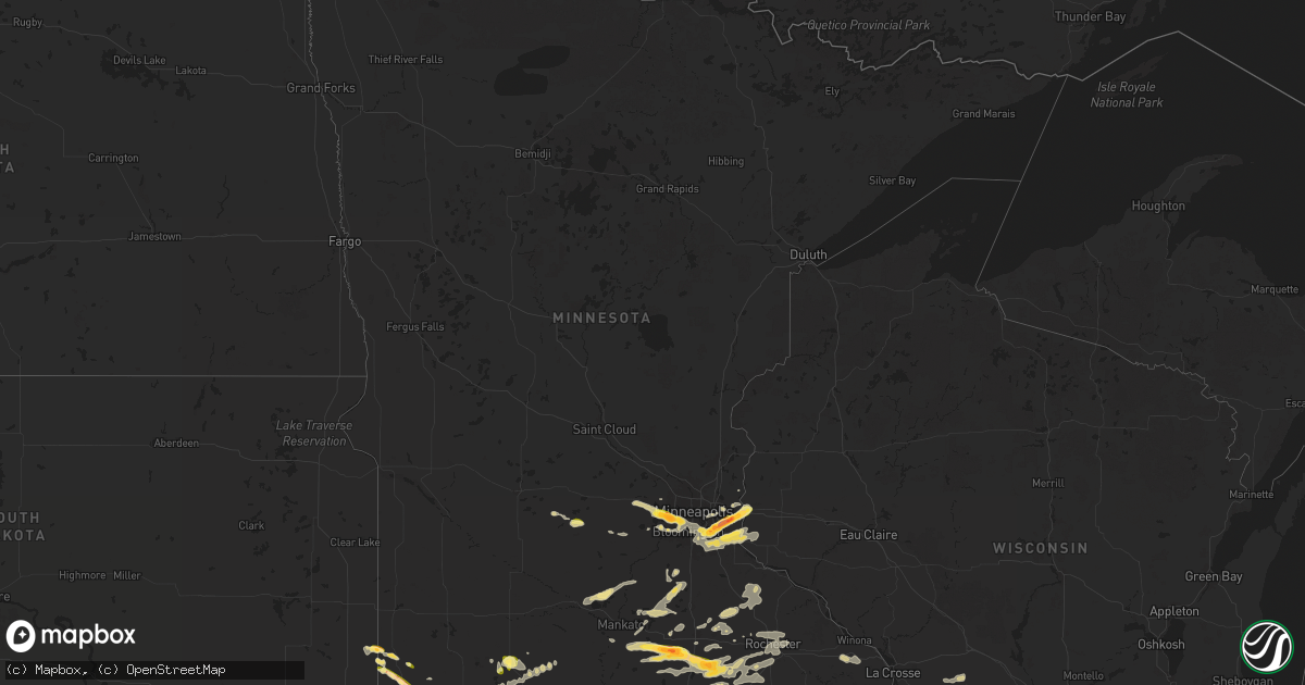
Hail Map in Minnesota on September 21, 2025
Get this storm
September 21 map
$229
one time, instant access
Download today. No call, no setup
Keep the $229
Bought the map and want the full workflow? Apply the entire $229 to a subscription within 7 days. None of it is wasted.
Every map, not just this one
This buys you this map. Subscription and you get every map we run, in the markets you choose from a few cities to whole states to nationwide. Plus real-time alerts the moment a storm fires.
Contact data
Name, contact info, occupancy, even credit band for addresses in the footprint. You go from where it hit to who to call.
Become the source they trust
Unlimited branding weather history reports on demand. You already have the documented answer ready for the property owner, and you are the one who showed up with it.
Property data and RoofTrace estimates
Pull up any address you have got, its value and the exact code rules for that jurisdiction, straight from One Click Code. Then RoofTrace estimates the squares, pitch, and roof value, priced the way you price.
Storm reports in Minnesota
Minnesota
| Date | Description |
|---|---|
| 09/21/20256:59 PM CDT | A local report indicates 1.25 inch wind near Edgerton |
| 09/21/20256:51 PM CDT | Storm chaser reported increasing hail activity and size at 6:51 pm cdt. They also reported a rotating wall cloud. |
| 09/21/20256:00 PM CDT | A local report indicates 1.25 inch wind near 6 W Lemond |
| 09/21/20255:54 PM CDT | A local report indicates 2.00 inch wind near 6 NNW New Richland |
| 09/21/20255:51 PM CDT | Spotter measured hailstones of penny to quarter size. |
| 09/21/20255:41 PM CDT | A local report indicates 1.50 inch wind near 3 W Pipestone |
| 09/21/20255:33 PM CDT | A local report indicates 1.00 inch wind near 6 W Pipestone |
| 09/21/20255:16 PM CDT | Delayed report... Time estimated from radar. Hail covering the ground... With the largest stone quarter-sized. Also tree branches down. |
| 09/20/202511:05 PM CDT | Trained spotter reported pea sized hail and small branches down near county border. |
| 09/20/202510:57 PM CDT | A few trees snapped. Trunks roughly 6 to 12 inches in diameter. |
| 09/20/202510:57 PM CDT | A few trees snapped. Trunks roughly 6 to 12 inches in diameter. |
| 09/20/20259:47 PM CDT | Hail was quarter size or smaller. Time estimated from radar. |
| 09/20/20259:20 PM CDT | Report from mping: hen egg |
| 09/20/20259:16 PM CDT | Repo |
| 09/20/20259:16 PM CDT | Report from mping: ping pong ball (1.50 in. |
| 09/20/20259:16 PM CDT | Report from mping: ping pong ball |
| 09/20/20259:15 PM CDT | A local report indicates 1.75 inch wind near 1 SSW Minnetonka |
| 09/20/20259:15 PM CDT | (mp |
| 09/20/20259:14 PM CDT | A local report indicates 1.25 inch wind near 1 SSE Minnetonka |
| 09/20/20259:12 PM CDT | A local report indicates 1.00 inch wind near 1 NNW Hopkins |
| 09/20/20259:10 PM CDT | A local report indicates 1.00 inch wind near 2 W Hutchinson |
| 09/20/20259:07 PM CDT | A local report indicates 1.75 inch wind near 1 SE Deephaven |
| 09/20/20259:05 PM CDT | Report and picture sent via x. |
| 09/20/20259:04 PM CDT | Report from mping: quarter |
| 09/20/20258:30 PM CDT | Spotter reported quarter to half dollar sized hail at 8:30 pm cdt. |
| 09/20/20258:21 PM CDT | Report from mping: half dollar |
| 09/20/20258:21 PM CDT | Report from mping: ping pong ball |
| 09/20/20258:21 PM CDT | Report from mping: quarter |
| 09/20/20258:17 PM CDT | Sent via x. |
| 09/20/20258:14 PM CDT | Mping report. |
| 09/20/20258:10 PM CDT | Had about 2 minutes of 0.5 to 1.5 inch hail. |
| 09/20/20258:10 PM CDT | Picture sent via x. |
| 09/20/20258:07 PM CDT | A local report indicates 1.75 inch wind near 1 SSE South St. Paul |
| 09/20/20258:06 PM CDT | A local report indicates 1.00 inch wind near 1 NNE Inver Grove Heigh |
| 09/20/20257:30 PM CDT | Spotter reported heavy rain and quarter sized hail at 7:30 pm cdt. |
| 09/20/20257:10 PM CDT | Delayed report... Time estimated from radar. Golf ball size hail on hwy 30 west of blooming prairie. |
| 09/20/20257:08 PM CDT | Delayed report... Time estimated from radar. Lots of hail... The largest around quarter-sized. |
| 09/20/20257:00 PM CDT | Time estimated based on radar. |
| 09/20/20257:00 PM CDT | Public report of hail 1 inch at 7:00 pm cdt. |
All States Impacted by Hail Map on September 21, 2025
Cities Impacted by Hail Map on September 21, 2025
- Jamestown, TN
- Oneida, TN
- Pall Mall, TN
- Quincy, MO
- Weaubleau, MO
- Milford, OH
- Cincinnati, OH
- Loveland, OH
- Goshen, OH
- Wheatland, MO
- Pleasant Plain, OH
- Blanchester, OH
- Morrow, OH
- Williamsburg, KY
- Spencer, TN
- Ponce De Leon, FL
- Calhoun, KY
- Only, TN
- Morris, OK
- Boynton, OK
- Freeport, FL
- Duncan, OK
- Haskell, OK
- Defuniak Springs, FL
- Council Hill, OK
- Oktaha, OK
- Muskogee, OK
- Taft, OK
- Porter, OK
- Lewisport, KY
- Philpot, KY
- Westport, TN
- Holladay, TN
- Hawesville, KY
- Buena Vista, TN
- Wildersville, TN
- Yuma, TN
- Ardmore, OK
- Le Roy, IL
- Monee, IL
- Checotah, OK
- Lone Grove, OK
- Tell City, IN
- Cannelton, IN
- Morris, IL
- Warner, OK
- Seymour, TX
- Slater, MO
- Alligator, MS
- Wendell, ID
- Louisa, KY
- Miami, MO
- Marshall, MO
- Holliday, TX
- Derby, IN
- Mchenry, IL
- Woodstock, IL
- Frankfort, IL
- Coal City, IL
- Channahon, IL
- Wilmington, IL
- Lenoir City, TN
- Clarksdale, MS
- Leopold, IN
- Lexington, TN
- Porum, OK
- Gilliam, MO
- Crystal Lake, IL
- Henderson, TN
- Olney, TX
- Harriman, TN
- Madill, OK
- Webbers Falls, OK
- Parsons, TN
- Island Lake, IL
- Elwood, IL
- Round Lake, IL
- Wauconda, IL
- Ingleside, IL
- Grayslake, IL
- Fox Lake, IL
- Flat Rock, AL
- Mazon, IL
- Gardner, IL
- Matteson, IL
- Manhattan, IL
- Henrietta, TX
- Braceville, IL
- Park Valley, UT
- Mapleton, MN
- Good Thunder, MN
- Bowie, TX
- Nocona, TX
- Gainesville, TX
- Stigler, OK
- Bellevue, TX
- Garden City, MN
- Sulphur, OK
- Keota, OK
- Grouse Creek, UT
- Pemberton, MN
- Valley View, TX
- Lake Crystal, MN
- Era, TX
- Denison, TX
- Pottsboro, TX
- Sherman, TX
- Snowville, UT
- Malta, ID
- Eufaula, OK
- Saint Jo, TX
- Forestburg, TX
- Newcastle, TX
- Graham, TX
- Loving, TX
- Janesville, MN
- Sanger, TX
- Ringgold, TX
- Waseca, MN
- Murfreesboro, TN
- Flandreau, SD
- Mankato, MN
- Centerville, MO
- Quinton, OK
- Kinta, OK
- Vian, OK
- Sallisaw, OK
- Howe, TX
- Aubrey, TX
- Denton, TX
- Van Alstyne, TX
- Whitewright, TX
- Tom Bean, TX
- Whitefield, OK
- Waldorf, MN
- New Richland, MN
- Pipestone, MN
- Black, MO
- Anna, TX
- Ellendale, MN
- Owatonna, MN
- Belleview, MO
- New London, MO
- Niles, MI
- Spiro, OK
- Krum, TX
- Muldrow, OK
- Gans, OK
- Versailles, IL
- Kinderhook, IL
- Wilson, OK
- Ringling, OK
- Dowagiac, MI
- Barry, IL
- Dublin, TX
- Desdemona, TX
- Melissa, TX
- Edgerton, MN
- Waynesboro, MS
- Trent, SD
- Jasper, MN
- Perrin, TX
- Shreveport, LA
- De Leon, TX
- Breckenridge, TX
- South Bend, TX
- Mckinney, TX
- Blue Ridge, TX
- Blooming Prairie, MN
- Decatur, MI
- Alcester, SD
- Bossier City, LA
- Argyle, TX
- Whitt, TX
- Waterville, MN
- Hudson, SD
- Braidwood, IL
- Montgomery, MN
- Madison Lake, MN
- Cleveland, MN
- Elysian, MN
- Lawton, MI
- Paw Paw, MI
- Graford, TX
- Strawn, TX
- Mineral Wells, TX
- Mattawan, MI
- Barksdale Afb, LA
- Franklin, IL
- Alexander, IL
- Waverly, IL
- Webster, MN
- Elko New Market, MN
- Lonsdale, MN
- Caddo, TX
- New Prague, MN
- Benton, LA
- Lewisville, TX
- Moore, ID
- Mannsville, OK
- Hardwick, MN
- Loami, IL
- Richland, MI
- Luverne, MN
- Kenneth, MN
- Worthington, MN
- Rock Valley, IA
- Hawarden, IA
- Saint Paul Park, MN
- Hastings, MN
- Cottage Grove, MN
- Rochester, IL
- Morristown, MN
- Saint Paul, MN
- Inver Grove Heights, MN
- South Saint Paul, MN
- Okabena, MN
- Brewster, MN
- Mingus, TX
- Eureka, NV
- Rosemount, MN
- River Falls, WI
- Gordon, TX
- Sioux Center, IA
- Newport, MN
- Lakefield, MN
- Round Lake, MN
- Montrose, MN
- Delano, MN
- Blackfoot, ID
- Ocheyedan, IA
- Gustine, TX
- Ranger, TX
- Ireton, IA
- Burnsville, MN
- Magnolia, MN
- Adrian, MN
- Afton, MN
- Lake Elmo, MN
- Cosmos, MN
- Windom, MN
- Maurice, IA
- Carlton, TX
- Roland, OK
- Lakeland, MN
- Stillwater, MN
- Hudson, WI
- Maple Plain, MN
- Jackson, MN
- Bingham Lake, MN
- Stephenville, TX
- Litchfield, MN
- Hamilton, TX
- Mound, MN
- Long Lake, MN
- Wayzata, MN
- Hutchinson, MN
- Downs, IL
- Le Mars, IA
- Trimont, MN
- Odin, MN
- Fort Smith, AR
- Mountain Lake, MN
- Spring Park, MN
- Arkoma, OK
- Pocola, OK
- Excelsior, MN
- Minnetonka, MN
- Hopkins, MN
- New Richmond, WI
- Saint James, MN
- Ormsby, MN
- University Park, IL
- Crete, IL
- Park Forest, IL
- Chicago Heights, IL
- Steger, IL
- Thornton, IL
- Homewood, IL
- Hazel Crest, IL
- Glenwood, IL
- Butterfield, MN
- Minneapolis, MN
- Richton Park, IL
- Barling, AR
- Heron Lake, MN
- Eden Prairie, MN
- Evant, TX
- Van Buren, AR
- Chanhassen, MN
- Bunch, OK
- Cookson, OK
- Hamel, MN
- Glencoe, MN
- Ellsinore, MO
- Greenville, MO
- Young America, MN
- Plato, MN
- Alpha, MN
- Norwood Young America, MN
- Williamsville, MO
- Mill Spring, MO
- Poplar Bluff, MO
- Silver Lake, MN
- Lester Prairie, MN
- New Germany, MN
- Watertown, MN
- Saint Bonifacius, MN
- Mayer, MN
- Courtland, MN
- New Ulm, MN
- Marquand, MO
- Saint Peter, MN
- Victoria, MN
- Waconia, MN
- Nicollet, MN
- Farmington, MN
- Chaska, MN
- Le Sueur, MN
- Hartland, MN
- Prescott, WI
- Eagle Lake, MN
- Kilkenny, MN
- Claremont, MN
- Kenyon, MN
- Faribault, MN
- Lismore, MN
- Northfield, MN
- Bayport, MN
- West Concord, MN
- Wanamingo, MN
- Goodhue, MN
- Hayfield, MN
- Zumbrota, MN
- Mazeppa, MN
- Medford, MN
- Cecil, AR
- Ozark, AR
- Dodge Center, MN
- Ratcliff, AR
- Kasson, MN
- Mantorville, MN
- Sebree, KY
- Paris, AR
- Byron, MN
- Rochester, MN
- Oronoco, MN
- Justin, TX
- Ponder, TX
- Stewartville, MN
- Eyota, MN
- Sargeant, MN
- Waltham, MN
- Minnesota Lake, MN
- Foster, OK
- Geneva, MN
- Dexter, MN
- Brownsdale, MN
- Grand Meadow, MN
- Rushford, MN
- Albert Lea, MN
- Lewiston, MN
- Austin, MN
- Houston, MN
- Winona, MN
- Edinburg, IL
- Fort Worth, TX
- Roanoke, TX
- New Berlin, IL
- Mechanicsburg, IL
- Racine, MN
- Glenville, MN
- Hayward, MN
- Rose Creek, MN
- Sparta, WI
- Norwalk, WI
- Kendall, WI
- Hillsboro, WI
- Ontario, WI
- Wilton, WI
- Cashton, WI
- Hollandale, MN
- Lansing, MN


