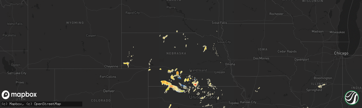
Hail Map in Nebraska on September 21, 2023
The weather event in Nebraska on September 21, 2023 includes Hail, Wind, and Tornado maps. 16 states and 344 cities were impacted and suffered possible damage. The total estimated number of properties impacted is 11,494.
Want more than just the map?
Turn this storm into a full workflow.
- Owner + property data so you know who to knock
- OnDemand branded weather history reports to win the "did we even have hail?" argument
- RoofTrace estimate so reps stop guessing numbers at the door
Bought this map? Upgrade within 7 days and we'll credit the $230. (10-15 min setup call)
Hail
Wind
Tornado
11,494
Estimated number of impacted properties by a 1.00" hail or larger3,655
Estimated number of impacted properties by a 1.75" hail or larger2,352
Estimated number of impacted properties by a 2.50" hail or largerStorm reports in Nebraska
Nebraska
| Date | Description |
|---|---|
| 09/21/20236:16 PM CDT | A local report indicates 1.00 inch wind near 8 SE Mccook |
| 09/21/20236:06 PM CDT | A local report indicates 1.75 inch wind near Red Cloud |
| 09/21/20236:05 PM CDT | Law enforcement reports hail increasing in size... Up to golf ball size. |
| 09/21/20236:00 PM CDT | Law enforcement reports quarter size hail occurring in red cloud. |
| 09/21/20235:55 PM CDT | Delayed report received of hail up to 2 inches in diameter at location. Time is radar estimated. |
| 09/21/20235:46 PM CDT | Various reports with largest report from law enforcement and fb with baseball sized hail. Large hail lasted about 25min. Lots of car damage. Trees leaves also took a be |
| 09/21/20235:30 PM CDT | Hail on the ground ranged from nickel to half dollar sized. |
| 09/21/20235:03 PM CDT | Quarter size hail south of rosemont. |
| 09/21/20235:00 PM CDT | Cwop station 9.5 miles sw mccook. |
| 09/21/20234:54 PM CDT | Tennis ball to baseball size hail reported on darr road near lauby cattle. Time estimated from radar. |
| 09/21/20234:51 PM CDT | A local report indicates 1.50 inch wind near 1 ENE Culbertson |
| 09/21/20234:50 PM CDT | Public report relayed via a storm chaser of possible softball size hail south of the darr interchange on interstate 80. Photos accompanying the report showed damage to |
| 09/21/20234:50 PM CDT | Hail to the size of green walnut. Time estimated from radar. |
| 09/21/20234:48 PM CDT | Social media report of golf ball size hail 6 miles south of axtell. |
| 09/21/20234:43 PM CDT | Public report of 1.5 inch hail becoming heavy rain. |
| 09/21/20234:41 PM CDT | Social media report of 2 inch hail in cowles. |
| 09/21/20234:40 PM CDT | A local report indicates 1.75 inch wind near Culbertson |
| 09/21/20234:27 PM CDT | Delayed report from social media. Time estimated by radar. |
| 09/21/20234:23 PM CDT | Report with photo from facebook. Location was between johnson lake and interstate 80. Time estimated from radar. |
| 09/21/20233:50 PM CDT | Spotter driving a semi on highway 6 ran into storm and had hail ranging from ping pong to tennis ball. Time approx by radar. |
| 09/21/20233:39 PM CDT | Mostly quarters with some half dollars mixed in. |
| 09/21/202312:05 AM CDT | Estimated wind gusts of 50 to 60 mph. Time estimated from radar. |
| 09/20/202310:03 PM CDT | Davis station. |
| 09/20/20238:30 PM CDT | Public report via social media with photo of estimated golf ball size hail in danbury with second round of storms. Time and location estimated. |
| 09/20/20237:46 PM CDT | County sheriff reported to dispatch. |
| 09/20/20237:11 PM CDT | Trained spotter reported gold ball sized hail in danbury. |
| 09/20/20237:11 PM CDT | Corrects previous hail report from danbury. Trained spotter reported golf ball sized hail in danbury. |
| 09/20/20237:00 PM CDT | Gust recorded 8ssw of indianola... Ne. Unable to find specific site id. |
| 09/20/20237:00 PM CDT | Public report via social media of constant hail pea to quarter size between approx. 7 to 750 pm cdt with first round of storms through danbury. Location estimated. |
All States Impacted by Hail Map on September 21, 2023
Cities Impacted by Hail Map on September 21, 2023
- Dodge, NE
- Winner, SD
- Stanton, NE
- Colon, NE
- Cedar Bluffs, NE
- Newport, NE
- Stuart, NE
- Beresford, SD
- Centerville, SD
- Laurel, NE
- Mills, NE
- Tilden, NE
- Wisner, NE
- West Point, NE
- Plainview, NE
- Meadow Grove, NE
- Pierce, NE
- Osmond, NE
- Carroll, NE
- Colome, SD
- Cody, NE
- Pilger, NE
- Brunswick, NE
- Neligh, NE
- Winside, NE
- Page, NE
- Wayne, NE
- Howells, NE
- Red Cloud, NE
- Inavale, NE
- Beloit, KS
- Simpson, KS
- Culbertson, NE
- Trenton, NE
- Palisade, NE
- Bladen, NE
- Riverton, NE
- Campbell, NE
- Stockville, NE
- Moorefield, NE
- Farnam, NE
- Elwood, NE
- Lexington, NE
- Cozad, NE
- Eustis, NE
- Gothenburg, NE
- Alma, NE
- Holdrege, NE
- Wilcox, NE
- Brady, NE
- Maxwell, NE
- Axtell, NE
- Funk, NE
- Hildreth, NE
- McCook, NE
- Blue Hill, NE
- Minden, NE
- Overton, NE
- Sumner, NE
- Guide Rock, NE
- Lawrence, NE
- Hebron, NE
- Gilead, NE
- Denison, TX
- Sherman, TX
- Emporia, KS
- Strong City, KS
- Indianola, NE
- Ponder, TX
- Krum, TX
- Denton, TX
- Roseland, NE
- Valentine, NE
- Fairbury, NE
- Hubbell, NE
- Alexandria, NE
- Thackerville, OK
- Michigamme, MI
- Sanford, FL
- Mankato, KS
- Webber, KS
- Concordia, KS
- Atkinson, NE
- Oakdale, IL
- Nashville, IL
- Shickley, NE
- Strang, NE
- Bruning, NE
- Council Grove, KS
- Coulterville, IL
- Addieville, IL
- Thedford, NE
- Colbert, OK
- Howe, TX
- Clifton, KS
- Alta Vista, KS
- Aurora, KS
- Longwood, FL
- Clinton, IL
- Chiefland, FL
- Orlando, FL
- Clay Center, KS
- Morrowville, KS
- Endicott, NE
- Glasco, KS
- Belleville, KS
- Heartwell, NE
- Naper, NE
- Altamonte Springs, FL
- Maitland, FL
- Bells, TX
- Gibbon, NE
- Lebanon, KS
- Burr Oak, KS
- Winter Springs, FL
- Lake Mary, FL
- Casselberry, FL
- Winter Park, FL
- Clyde, KS
- Osage City, KS
- Reading, KS
- Saint Jo, TX
- Bronson, FL
- Wallace, NE
- Cottonwood Falls, KS
- Sutherland, NE
- Danbury, NE
- Venango, NE
- Bertrand, NE
- Oberlin, KS
- Lebanon, NE
- Norcatur, KS
- Amsterdam, MO
- Drexel, MO
- Wilsonville, NE
- Neosho Rapids, KS
- Bushnell, NE
- Kimball, NE
- Fritch, TX
- Masterson, TX
- Borger, TX
- Stinnett, TX
- Norton, KS
- Stamford, NE
- Orleans, NE
- Phillipsburg, KS
- Lenora, KS
- Republican City, NE
- Logan, KS
- Prairie View, KS
- Spring Hill, KS
- Edgerton, KS
- Decatur, TX
- Athol, KS
- Kensington, KS
- Gaylord, KS
- Gainesville, TX
- Grover, CO
- Lebo, KS
- Du Pont, GA
- Cartwright, OK
- Lamar, AR
- Clarksville, AR
- Mount Pulaski, IL
- Arthur, NE
- Lemoyne, NE
- Upland, NE
- Oxford, NE
- Brule, NE
- Granite City, IL
- Saint Louis, MO
- Bayard, NE
- Park, KS
- Gove, KS
- Admire, KS
- Johnstown, NE
- Atwood, KS
- Smith Center, KS
- Kearney, NE
- Mcalester, OK
- Indianola, OK
- Whitesboro, TX
- Riley, KS
- Leonardville, KS
- Bartley, NE
- Hartford, KS
- Lane, IL
- Maroa, IL
- Alma, KS
- La Cygne, KS
- Cuervo, NM
- Chestnut, IL
- Kenney, IL
- Latham, IL
- Louisburg, KS
- Havana, AR
- Bridgeton, MO
- Maryland Heights, MO
- Earth City, MO
- Walsh, IL
- Sparta, IL
- Springer, OK
- Rich Hill, MO
- Agra, KS
- Lewellen, NE
- Bristol, GA
- Steeleville, IL
- Chester, IL
- Garnett, KS
- Booneville, AR
- Warrensburg, IL
- Lincoln, IL
- Sanger, TX
- Valley View, TX
- Tilden, IL
- Baldwin, IL
- Marissa, IL
- Babbitt, MN
- Ely, MN
- Holstein, NE
- Lincoln, KS
- Tucumcari, NM
- Davis, OK
- Dougherty, OK
- Sulphur, OK
- Glade, KS
- Herndon, KS
- Hume, MO
- Nocona, TX
- Leon, OK
- Harrisonville, MO
- Archie, MO
- Freeman, MO
- Odum, GA
- Screven, GA
- Bloomington, NE
- New Athens, IL
- Curtis, NE
- Lane, KS
- Princeton, KS
- Rantoul, KS
- Saint Ann, MO
- Ottawa, KS
- Esbon, KS
- Almena, KS
- Smithfield, NE
- Dix, NE
- Marysville, KS
- Jamestown, KS
- Norway, KS
- Scandia, KS
- Ohiowa, NE
- Milo, MO
- Cedar, KS
- El Dorado Springs, MO
- Sheldon, MO
- Pleasanton, KS
- Mahaska, KS
- Chester, NE
- Reynolds, NE
- Maywood, NE
- Walker, MO
- Nevada, MO
- Richards, MO
- Agenda, KS
- Okemah, OK
- Paden, OK
- Boley, OK
- Castle, OK
- Jamesport, MO
- Lock Springs, MO
- Barnard, KS
- Munden, KS
- Prague, OK
- Hamilton, MO
- Long Island, KS
- Ayr, NE
- Hagarville, AR
- Washington, KS
- Glen Elder, KS
- Cawker City, KS
- Kirwin, KS
- Jewell, KS
- Belvidere, NE
- Hanover, KS
- Hollenberg, KS
- Brookville, KS
- Menomonie, WI
- Mead, OK
- Bingham, NE
- Edgar, NE
- Palmer, KS
- Americus, KS
- Okmulgee, OK
- Depew, OK
- Bristow, OK
- Herington, KS
- Ramona, KS
- Lost Springs, KS
- White City, KS
- Wilsey, KS
- Bridgeport, NE
- Yale, OK
- Jennings, OK
- Drumright, OK
- Abilene, KS
- New Cambria, KS
- Salina, KS
- Hope, KS
- Solomon, KS
- Lincolnville, KS
- Tampa, KS
- Red Oak, OK
- Wilburton, OK
- Linn, KS
- Kinta, OK
- Quinton, OK
- Talihina, OK
- Kellyville, OK
- Gypsum, KS
- Skiatook, OK
- Prue, OK
- Hemingford, NE
- Alliance, NE
- Westmoreland, KS
- Harrisburg, NE
- Terlton, OK
- Osage, OK
- Hominy, OK
- Cleveland, OK
- Niantic, IL
- Kidder, MO
- Kingston, MO
- Burdick, KS
- Butler, MO
- Adrian, MO
- Minatare, NE
- Williamsburg, KS
- Frankfort, KS
- Marion, KS
- Sand Springs, OK
- Florence, KS
- Crow Agency, MT
- Elmdale, KS


