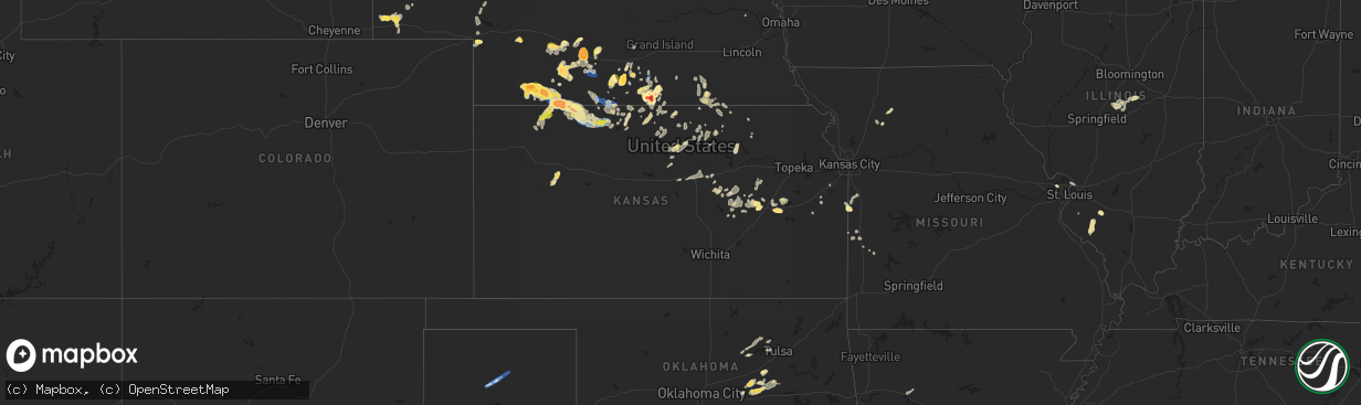
Hail Map in Kansas on September 21, 2023
The weather event in Kansas on September 21, 2023 includes Hail, Wind, and Tornado maps. 16 states and 344 cities were impacted and suffered possible damage. The total estimated number of properties impacted is 2,386.
Want more than just the map?
Turn this storm into a full workflow.
- Owner + property data so you know who to knock
- OnDemand branded weather history reports to win the "did we even have hail?" argument
- RoofTrace estimate so reps stop guessing numbers at the door
Bought this map? Upgrade within 7 days and we'll credit the $230. (10-15 min setup call)
Hail
Wind
Tornado
2,386
Estimated number of impacted properties by a 1.00" hail or larger106
Estimated number of impacted properties by a 1.75" hail or larger12
Estimated number of impacted properties by a 2.50" hail or largerStorm reports in Kansas
Kansas
| Date | Description |
|---|---|
| 09/21/20236:25 PM CDT | A local report indicates 1.00 inch wind near 2 NE Saffordville |
| 09/20/202311:46 PM CDT | Delayed report. Large tree uprooted in mankato along with several other large branches fallen or damaged. Time estimated from radar. |
| 09/20/202310:51 PM CDT | Nickel to quarter sized hail. Time est from radar. |
| 09/20/202310:02 PM CDT | Ems spotter noted heavy dumpster moved approx 100ft in parking lot from high winds. Time approx from radar. |
| 09/20/20239:59 PM CDT | A local report indicates 74 MPH wind near 6 SSE Norton |
| 09/20/20239:58 PM CDT | Davis station. |
| 09/20/20239:49 PM CDT | Sustained at 45 mph. |
| 09/20/20239:36 PM CDT | Delayed report of nickel to quarter sized hail in oberlin. |
| 09/20/20239:36 PM CDT | Delayed report of 1 inch hail at highway 36 and 83 in oberlin. |
| 09/20/20239:00 PM CDT | Delayed report received via social media of an estimated 60 mph thunderstorm wind gusts as well as pea to marble sized hail at location. Time is radar estimated. |
| 09/20/20237:56 PM CDT | A local report indicates 1.75 inch wind near Neosho Rapids |
| 09/20/20237:30 PM CDT | Delayed report sent via social media of baseball sized hail approximately 7 miles se of danbury... Ne and 1 mile into ks from the state border. |
All States Impacted by Hail Map on September 21, 2023
Cities Impacted by Hail Map on September 21, 2023
- Dodge, NE
- Winner, SD
- Stanton, NE
- Colon, NE
- Cedar Bluffs, NE
- Newport, NE
- Stuart, NE
- Beresford, SD
- Centerville, SD
- Laurel, NE
- Mills, NE
- Tilden, NE
- Wisner, NE
- West Point, NE
- Plainview, NE
- Meadow Grove, NE
- Pierce, NE
- Osmond, NE
- Carroll, NE
- Colome, SD
- Cody, NE
- Pilger, NE
- Brunswick, NE
- Neligh, NE
- Winside, NE
- Page, NE
- Wayne, NE
- Howells, NE
- Red Cloud, NE
- Inavale, NE
- Beloit, KS
- Simpson, KS
- Culbertson, NE
- Trenton, NE
- Palisade, NE
- Bladen, NE
- Riverton, NE
- Campbell, NE
- Stockville, NE
- Moorefield, NE
- Farnam, NE
- Elwood, NE
- Lexington, NE
- Cozad, NE
- Eustis, NE
- Gothenburg, NE
- Alma, NE
- Holdrege, NE
- Wilcox, NE
- Brady, NE
- Maxwell, NE
- Axtell, NE
- Funk, NE
- Hildreth, NE
- McCook, NE
- Blue Hill, NE
- Minden, NE
- Overton, NE
- Sumner, NE
- Guide Rock, NE
- Lawrence, NE
- Hebron, NE
- Gilead, NE
- Denison, TX
- Sherman, TX
- Emporia, KS
- Strong City, KS
- Indianola, NE
- Ponder, TX
- Krum, TX
- Denton, TX
- Roseland, NE
- Valentine, NE
- Fairbury, NE
- Hubbell, NE
- Alexandria, NE
- Thackerville, OK
- Michigamme, MI
- Sanford, FL
- Mankato, KS
- Webber, KS
- Concordia, KS
- Atkinson, NE
- Oakdale, IL
- Nashville, IL
- Shickley, NE
- Strang, NE
- Bruning, NE
- Council Grove, KS
- Coulterville, IL
- Addieville, IL
- Thedford, NE
- Colbert, OK
- Howe, TX
- Clifton, KS
- Alta Vista, KS
- Aurora, KS
- Longwood, FL
- Clinton, IL
- Chiefland, FL
- Orlando, FL
- Clay Center, KS
- Morrowville, KS
- Endicott, NE
- Glasco, KS
- Belleville, KS
- Heartwell, NE
- Naper, NE
- Altamonte Springs, FL
- Maitland, FL
- Bells, TX
- Gibbon, NE
- Lebanon, KS
- Burr Oak, KS
- Winter Springs, FL
- Lake Mary, FL
- Casselberry, FL
- Winter Park, FL
- Clyde, KS
- Osage City, KS
- Reading, KS
- Saint Jo, TX
- Bronson, FL
- Wallace, NE
- Cottonwood Falls, KS
- Sutherland, NE
- Danbury, NE
- Venango, NE
- Bertrand, NE
- Oberlin, KS
- Lebanon, NE
- Norcatur, KS
- Amsterdam, MO
- Drexel, MO
- Wilsonville, NE
- Neosho Rapids, KS
- Bushnell, NE
- Kimball, NE
- Fritch, TX
- Masterson, TX
- Borger, TX
- Stinnett, TX
- Norton, KS
- Stamford, NE
- Orleans, NE
- Phillipsburg, KS
- Lenora, KS
- Republican City, NE
- Logan, KS
- Prairie View, KS
- Spring Hill, KS
- Edgerton, KS
- Decatur, TX
- Athol, KS
- Kensington, KS
- Gaylord, KS
- Gainesville, TX
- Grover, CO
- Lebo, KS
- Du Pont, GA
- Cartwright, OK
- Lamar, AR
- Clarksville, AR
- Mount Pulaski, IL
- Arthur, NE
- Lemoyne, NE
- Upland, NE
- Oxford, NE
- Brule, NE
- Granite City, IL
- Saint Louis, MO
- Bayard, NE
- Park, KS
- Gove, KS
- Admire, KS
- Johnstown, NE
- Atwood, KS
- Smith Center, KS
- Kearney, NE
- Mcalester, OK
- Indianola, OK
- Whitesboro, TX
- Riley, KS
- Leonardville, KS
- Bartley, NE
- Hartford, KS
- Lane, IL
- Maroa, IL
- Alma, KS
- La Cygne, KS
- Cuervo, NM
- Chestnut, IL
- Kenney, IL
- Latham, IL
- Louisburg, KS
- Havana, AR
- Bridgeton, MO
- Maryland Heights, MO
- Earth City, MO
- Walsh, IL
- Sparta, IL
- Springer, OK
- Rich Hill, MO
- Agra, KS
- Lewellen, NE
- Bristol, GA
- Steeleville, IL
- Chester, IL
- Garnett, KS
- Booneville, AR
- Warrensburg, IL
- Lincoln, IL
- Sanger, TX
- Valley View, TX
- Tilden, IL
- Baldwin, IL
- Marissa, IL
- Babbitt, MN
- Ely, MN
- Holstein, NE
- Lincoln, KS
- Tucumcari, NM
- Davis, OK
- Dougherty, OK
- Sulphur, OK
- Glade, KS
- Herndon, KS
- Hume, MO
- Nocona, TX
- Leon, OK
- Harrisonville, MO
- Archie, MO
- Freeman, MO
- Odum, GA
- Screven, GA
- Bloomington, NE
- New Athens, IL
- Curtis, NE
- Lane, KS
- Princeton, KS
- Rantoul, KS
- Saint Ann, MO
- Ottawa, KS
- Esbon, KS
- Almena, KS
- Smithfield, NE
- Dix, NE
- Marysville, KS
- Jamestown, KS
- Norway, KS
- Scandia, KS
- Ohiowa, NE
- Milo, MO
- Cedar, KS
- El Dorado Springs, MO
- Sheldon, MO
- Pleasanton, KS
- Mahaska, KS
- Chester, NE
- Reynolds, NE
- Maywood, NE
- Walker, MO
- Nevada, MO
- Richards, MO
- Agenda, KS
- Okemah, OK
- Paden, OK
- Boley, OK
- Castle, OK
- Jamesport, MO
- Lock Springs, MO
- Barnard, KS
- Munden, KS
- Prague, OK
- Hamilton, MO
- Long Island, KS
- Ayr, NE
- Hagarville, AR
- Washington, KS
- Glen Elder, KS
- Cawker City, KS
- Kirwin, KS
- Jewell, KS
- Belvidere, NE
- Hanover, KS
- Hollenberg, KS
- Brookville, KS
- Menomonie, WI
- Mead, OK
- Bingham, NE
- Edgar, NE
- Palmer, KS
- Americus, KS
- Okmulgee, OK
- Depew, OK
- Bristow, OK
- Herington, KS
- Ramona, KS
- Lost Springs, KS
- White City, KS
- Wilsey, KS
- Bridgeport, NE
- Yale, OK
- Jennings, OK
- Drumright, OK
- Abilene, KS
- New Cambria, KS
- Salina, KS
- Hope, KS
- Solomon, KS
- Lincolnville, KS
- Tampa, KS
- Red Oak, OK
- Wilburton, OK
- Linn, KS
- Kinta, OK
- Quinton, OK
- Talihina, OK
- Kellyville, OK
- Gypsum, KS
- Skiatook, OK
- Prue, OK
- Hemingford, NE
- Alliance, NE
- Westmoreland, KS
- Harrisburg, NE
- Terlton, OK
- Osage, OK
- Hominy, OK
- Cleveland, OK
- Niantic, IL
- Kidder, MO
- Kingston, MO
- Burdick, KS
- Butler, MO
- Adrian, MO
- Minatare, NE
- Williamsburg, KS
- Frankfort, KS
- Marion, KS
- Sand Springs, OK
- Florence, KS
- Crow Agency, MT
- Elmdale, KS


