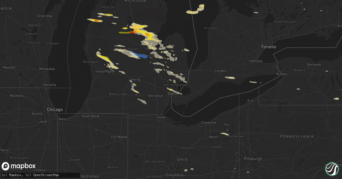
Hail Map on September 21, 2022
Get this storm
September 21 map
$229
one time, instant access
Download today. No call, no setup
Keep the $229
Bought the map and want the full workflow? Apply the entire $229 to a subscription within 7 days. None of it is wasted.
Every map, not just this one
This buys you this map. Subscription and you get every map we run, in the markets you choose from a few cities to whole states to nationwide. Plus real-time alerts the moment a storm fires.
Contact data
Name, contact info, occupancy, even credit band for addresses in the footprint. You go from where it hit to who to call.
Become the source they trust
Unlimited branding weather history reports on demand. You already have the documented answer ready for the property owner, and you are the one who showed up with it.
Property data and RoofTrace estimates
Pull up any address you have got, its value and the exact code rules for that jurisdiction, straight from One Click Code. Then RoofTrace estimates the squares, pitch, and roof value, priced the way you price.
States Impacted by Hail Map on September 21, 2022
Storm reports
West Virginia
| Date | Description |
|---|---|
| 09/21/20225:01 AM CDT | At 1000 PM EDT, a severe thunderstorm was located 9 miles northwest of Barnesville, moving east at 35 mph. HAZARD...60 mph wind gusts. SOURCE...Radar indicated. IMPACT...Expect damage to trees and power lines, resulting in some power outages. Locations impacted include... Wheeling, Martins Ferry, St. Clairsville, Bellaire, Barnesville, Cadiz, Bridgeport, Benwood, Bethesda, Antrim, Hopedale, and Flushing. |
| 09/20/20229:58 PM CDT | Tree down on walnut grove rd/stone church rd in ohio county wv from thunderstorms |
Utah
| Date | Description |
|---|---|
| 09/21/20222:45 PM CDT | Measured from dpg14. |
| 09/21/20227:41 AM CDT | At 1240 PM MDT, a severe thunderstorm was located 11 miles northwest of Great Salt Lake South of the Causeway, or 34 miles west of Hill Air Force Base, moving north at 40 mph. HAZARD...60 mph wind gusts and quarter size hail. SOURCE...Radar indicated. IMPACT...Hail damage to vehicles is expected. Expect wind damage to roofs, siding, and trees. Locations impacted include... Great Salt Lake North of the Causeway, Great Salt Lake South of the Causeway and Hat Island. |
| 09/21/20227:26 AM CDT | At 1226 PM MDT, a severe thunderstorm was located 20 miles southwest of Nephi, moving northeast at 45 mph. HAZARD...60 mph wind gusts and quarter size hail. SOURCE...Radar indicated. IMPACT...Hail damage to vehicles is expected. Expect wind damage to roofs, siding, and trees. Locations impacted include... Nephi, Elberta, Mona and Leamington. This includes the following highways... Interstate 15 between mile markers 218 and 220, and between milemarkers 226 and 237. US Route 6 between mile markers 147 and 149. |
| 09/21/20222:17 AM CDT | At 716 PM MDT, a severe thunderstorm was located 22 miles south of Park Valley, or 38 miles southwest of Snowville, moving northeast at 30 mph. HAZARD...60 mph wind gusts. SOURCE...Mesonet weather station measured gust to 63 mph. IMPACT...Expect damage to roofs, siding, and trees. Locations impacted include... Great Salt Lake North of the Causeway and Locomotive Springs. |
| 09/20/202210:47 PM CDT | At 347 PM MDT, a severe thunderstorm was located 16 miles southwest of Snowville, moving northwest at 65 mph. HAZARD...70 mph wind gusts and ping pong ball size hail. SOURCE...Radar indicated. IMPACT...People and animals outdoors will be injured. Expect hail damage to roofs, siding, windows, and vehicles. Expect considerable tree damage. Wind damage is also likely to mobile homes, roofs, and outbuildings. Locations impacted include... Snowville, Curlew Junction and Locomotive Springs. This includes the following highways... Interstate 84 between mile markers 1 and 12. Utah Route 30 between mile markers 66 and 90. |
| 09/20/20229:58 PM CDT | At 257 PM MDT, a severe thunderstorm was located near Magna, or 8 miles west of West Valley City, moving north at 55 mph. HAZARD...60 mph wind gusts and quarter size hail. SOURCE...Radar indicated. IMPACT...Hail damage to vehicles is expected. Expect wind damage to roofs, siding, and trees. Locations impacted include... Salt Lake City, West Valley City, Layton, Hill Air Force Base, Clearfield, Kaysville, Syracuse, Clinton, South Weber, Magna, West Point, Sunset, Antelope Island State Park and Lake Point.This includes the following highways... Interstate 15 between mile markers 329 and 337. Interstate 84 near mile marker 86. Interstate 80 in Utah between mile markers 98 and 113. |
| 09/20/20229:32 PM CDT | At 232 PM MDT, a severe thunderstorm was located over Ophir, or 13 miles southeast of Tooele, moving north at 50 mph. HAZARD...60 mph wind gusts and quarter size hail. SOURCE...Radar indicated. IMPACT...Hail damage to vehicles is expected. Expect wind damage to roofs, siding, and trees. Locations impacted include... Salt Lake City, West Valley City, Tooele, West Jordan, South Jordan, Herriman, North Salt Lake, Stansbury Park, Cedar Fort, Ophir, Kearns, Salt Lake City International Airport, Magna, Bingham Canyon Mine, Oquirrh, Tooele Army Depot South, Camp Williams, Fairfield, Copperton and Lake Point.This includes Interstate 80 in Utah between mile markers 96 and 116. |
| 09/20/20229:18 PM CDT | At 218 PM MDT, a severe thunderstorm was located 15 miles north of Morgan, moving northeast at 25 mph. HAZARD...Ping pong ball size hail and 60 mph wind gusts. SOURCE...Radar indicated. IMPACT...People and animals outdoors will be injured. Expect hail damage to roofs, siding, windows, and vehicles. Expect wind damage to roofs, siding, and trees. Locations impacted include... Huntsville, Nordic Valley, Powder Mountain, Causey Reservoir, Pineview Reservoir and Avon. |
| 09/20/20229:11 PM CDT | At 210 PM MDT, a severe thunderstorm was located over Brigham Young University, or over Provo, moving northeast at 35 mph. HAZARD...60 mph wind gusts and quarter size hail. SOURCE...Radar indicated. IMPACT...Hail damage to vehicles is expected. Expect wind damage to roofs, siding, and trees. Locations impacted include... Provo, Heber City, Orem, Spanish Fork, Springville, Heber, Lindon, Mapleton, Daniel, Vineyard, Brigham Young University, Wasatch Mountain State Park, Palmyra, Timber Lakes, Lake Shore, Utah Lake, Midway, Charleston, Wallsburg and Deer Creek State Park.This includes the following highways... Interstate 15 between mile markers 257 and 271. US Route 6 between mile markers 174 and 177. US Route 40 between mile markers 11 and 25. |
| 09/20/20229:04 PM CDT | At 203 PM MDT, a severe thunderstorm was located 8 miles east of Vernon, or 26 miles east of Dugway English Village, moving north at 35 mph. HAZARD...60 mph wind gusts and quarter size hail. SOURCE...Radar indicated. IMPACT...Hail damage to vehicles is expected. Expect wind damage to roofs, siding, and trees. Locations impacted include... Ophir, Tooele Army Depot South, Rush Valley, Faust and Lofgreen. |
| 09/20/20228:59 PM CDT | At 159 PM MDT, a severe thunderstorm was located 13 miles west of Escalante, moving north at 30 mph. HAZARD...60 mph wind gusts and quarter size hail. SOURCE...Radar indicated. IMPACT...Hail damage to vehicles is expected. Expect wind damage to roofs, siding, and trees. Locations impacted include... Antimony. |
| 09/20/20228:48 PM CDT | At 148 PM MDT, a severe thunderstorm was located over Benjamin, or near Payson, moving northeast at 30 mph. HAZARD...60 mph wind gusts and quarter size hail. SOURCE...Radar indicated. IMPACT...Hail damage to vehicles is expected. Expect wind damage to roofs, siding, and trees. Locations impacted include... Provo, Payson, Orem, Spanish Fork, Pleasant Grove, Springville, Lindon, Santaquin, Mapleton, Salem, Elk Ridge, Woodland Hills, Vineyard, Brigham Young University, Palmyra, Benjamin, Lake Shore, Spring Lake, Utah Lake and West Mountain.This includes the following highways... Interstate 15 between mile markers 245 and 274. US Route 6 between mile markers 174 and 177. |
| 09/20/20228:29 PM CDT | At 129 PM MDT, a severe thunderstorm was located near Henrieville, or 20 miles southwest of Escalante, moving north at 35 mph. HAZARD...60 mph wind gusts and quarter size hail. SOURCE...Radar indicated. IMPACT...Hail damage to vehicles is expected. Expect wind damage to roofs, siding, and trees. This severe thunderstorm will remain over mainly rural areas of south central Garfield County.This includes Utah Route 12 between mile markers 33 and 57. |
| 09/20/20228:10 PM CDT | At 110 PM MDT, a severe thunderstorm was located near Hooper, or 8 miles west of Ogden, moving northeast at 30 mph. HAZARD...60 mph wind gusts and quarter size hail. SOURCE...Radar indicated. IMPACT...Hail damage to vehicles is expected. Expect wind damage to roofs, siding, and trees. Locations impacted include... Ogden, Brigham City, North Ogden, Hooper, Perry, Willard, Marriott-Slaterville, Mantua, South Willard, West Haven, Pleasant View, Farr West, Harrisville, Plain City, West Warren, Wilson, Liberty, Warren, West Weber and Slaterville.This includes Interstate 15 between mile markers 344 and 365. |
| 09/20/20227:44 PM CDT | Measured from groome site... Ur305. |
Illinois
| Date | Description |
|---|---|
| 09/20/20228:24 PM CDT | The back corner of a 2 story apartment building was damaged including a portion of the roof removed. |
| 09/20/20228:24 PM CDT | Two trees reported down... One on north main street and another at kester street and railroad street. |
Kentucky
| Date | Description |
|---|---|
| 09/20/20227:10 PM CDT | Numerous trees down between union... Walton... And verona. |
New York
| Date | Description |
|---|---|
| 09/21/20226:57 AM CDT | At 1157 PM EDT, a severe thunderstorm was located near Varysburg, or 11 miles east of East Aurora, moving east at 50 mph. HAZARD...60 mph wind gusts and quarter size hail. SOURCE...Radar indicated. IMPACT...Minor damage to vehicles is possible. Expect wind damage to trees and power lines. Locations impacted include... Geneseo, Letchworth State Park, Perry, Warsaw, Mount Morris, Conesus, Lima, Hemlock, Wales Center and Varysburg.This includes Interstate 390 between exits 6 and 9. |
| 09/21/20226:45 AM CDT | At 1144 PM EDT, a severe thunderstorm was located over Newfane, or 7 miles north of Lockport, moving east at 45 mph. HAZARD...60 mph wind gusts and quarter size hail. SOURCE...Radar indicated. IMPACT...Minor damage to vehicles is possible. Expect wind damage to trees and power lines. Locations impacted include... Greece, Chili, Lockport, Brockport, Medina, Albion, Hilton, Hamlin Beach State Park, Gates-North Gates and Newfane. |
| 09/21/20226:42 AM CDT | At 1141 PM EDT, a severe thunderstorm was located 7 miles northwest of Silver Creek, or 7 miles north of Dunkirk, moving east at 50 mph. HAZARD...60 mph wind gusts and quarter size hail. SOURCE...Radar indicated. IMPACT...Minor damage to vehicles is possible. Expect wind damage to trees and power lines. Locations impacted include... Dunkirk, Fredonia, Hamburg, East Aurora, Evans, Boston, Eden, Springville, Colden and Orchard Park.This includes Interstate 90 between exits 57 and 59. |
| 09/21/20221:12 AM CDT | Wires down... Causing a power outage on seneca boulevard. Time estimated from radar. |
| 09/21/20221:03 AM CDT | Trees down in phelps. |
| 09/21/202212:30 AM CDT | Tree down on wires. |
| 09/21/202212:13 AM CDT | Trees down in franklinville. |
| 09/21/202212:10 AM CDT | Multiple trees down along state route 19 in fillmore. |
| 09/20/202211:39 PM CDT | Tree down in the road. |
Idaho
| Date | Description |
|---|---|
| 09/21/20226:00 PM CDT | Pilot gold id. |
| 09/21/20225:30 PM CDT | Itd inl puzzle. |
| 09/21/20225:20 PM CDT | Noaa arl frd dead man canyon. |
| 09/21/20223:44 PM CDT | Ohio gulch raws. |
| 09/21/20222:54 PM CDT | Itd timmerman hill. |
| 09/21/20221:42 PM CDT | Mesonet station pcki1 pole creek. |
| 09/21/20221:08 PM CDT | A local report indicates 61 MPH wind near 5 S TWIN FALLS |
| 09/21/20227:22 AM CDT | At 1221 PM MDT, a severe thunderstorm was located over Kimberly, or near Twin Falls, moving northeast at 60 mph. HAZARD...65 mph wind gusts. SOURCE...61 mph gust measured at Twin Falls Airport. IMPACT...Expect damage to roofs, siding, and trees. This severe thunderstorm will be near... Jerome, Eden and Minidoka National Monument around 1230 PM MDT. |
| 09/21/20222:46 AM CDT | At 746 PM MDT, a severe thunderstorm was located over Inkom, or 8 miles east of Pocatello, moving northeast at 45 mph. HAZARD...60 mph wind gusts and nickel size hail. SOURCE...Radar indicated. IMPACT...Expect damage to roofs, siding, and trees. Locations impacted include... Eastern Pocatello, Chesterfield Reservoir, Inkom, Portneuf Gap, Fort Hall Mount Putnam and Fort Hall Putnam Lodge. |
| 09/21/20222:05 AM CDT | At 704 PM MDT, a severe thunderstorm was located 11 miles south of Fort Hall Bannock Peak, or 22 miles southeast of Neeley, moving northeast at 35 mph. HAZARD...60 mph wind gusts and nickel size hail. SOURCE...Radar indicated. IMPACT...Expect damage to roofs, siding, and trees. Locations impacted include... Pauline, Arbon and Mink Creek Pass. |
| 09/21/20222:00 AM CDT | At 659 PM MDT, a severe thunderstorm was located near Fort Hall Bannock Peak, or 10 miles southeast of American Falls, moving northeast at 35 mph. HAZARD...60 mph wind gusts and nickel size hail. SOURCE...Radar indicated. IMPACT...Expect damage to roofs, siding, and trees. Locations impacted include... Pocatello, American Falls, Neeley, American Falls Reservoir, Chubbuck, Fort Hall Bannock Peak, Portneuf Gap, Fort Hall Bannock Creek Lodge, Pocatello Airport, Sterling and Mink Creek Pass. |
| 09/21/20221:53 AM CDT | At 652 PM MDT, a severe thunderstorm was located 8 miles southwest of Snowville, moving northeast at 30 mph. HAZARD...60 mph wind gusts. SOURCE...Radar indicated. IMPACT...Expect damage to roofs, siding, and trees. Locations impacted include... Snowville, Curlew Junction and Locomotive Springs. This includes the following highways... Interstate 84 between mile markers 0 and 18. Utah Route 30 between mile markers 71 and 90. |
| 09/21/20221:32 AM CDT | At 632 PM MDT, a severe thunderstorm was located near Rockland, or 17 miles south of Neeley, moving northeast at 35 mph. HAZARD...60 mph wind gusts and nickel size hail. SOURCE...Radar indicated. IMPACT...Expect damage to roofs, siding, and trees. Locations impacted include... American Falls, Neeley, western American Falls Reservoir, Rockland, Fort Hall Bannock Peak and Massacre Rocks. |
| 09/20/202211:44 PM CDT | At 444 PM MDT, a severe thunderstorm was located near Northwest Inl, or 9 miles west of Terreton, moving north at 35 mph. HAZARD...70 mph wind gusts and penny size hail. SOURCE...Radar indicated. IMPACT...Expect considerable tree damage. Damage is likely to mobile homes, roofs, and outbuildings. Locations impacted include... Dubois, Terreton, Mud Lake, Northwest Inl, Monteview and Small. |
| 09/20/202211:34 PM CDT | At 434 PM MDT, a severe thunderstorm was located 12 miles north of Juniper, or 22 miles east of Malta, moving north at 50 mph. HAZARD...60 mph wind gusts and quarter size hail. SOURCE...Radar indicated. IMPACT...Hail damage to vehicles is expected. Expect wind damage to roofs, siding, and trees. Locations impacted include... American Falls, Neeley, Rockland, Massacre Rocks, Sublett Reservoir and Roy. |
| 09/20/20229:26 PM CDT | At 226 PM MDT, a severe thunderstorm was located over Grace, or 10 miles southwest of Soda Springs, moving northeast at 35 mph. HAZARD...Quarter size hail. SOURCE...Radar indicated. IMPACT...Damage to vehicles is expected. Locations impacted include... Soda Springs, Blackfoot Reservoir, Grace, Henry and Niter. |
| 09/20/20228:00 PM CDT | Several scattered large trees damaged with a few down along east fork of rock creek. |
| 09/20/20227:50 PM CDT | Several large limbs down in a residence along rockland highway. Time estimated via radar. |
| 09/20/20227:19 PM CDT | Raft river raws. |
New Hampshire
| Date | Description |
|---|---|
| 09/21/20226:36 AM CDT | Reported by weather spotter: delayed report: observed a few trees toppled by early morning thunderstorm along nh hwy 119 in the vicinity of rindge. Time estimated by ra |
Indiana
| Date | Description |
|---|---|
| 09/21/20226:45 PM CDT | Trees down on state route 56. Time estimated from radar. |
| 09/21/20226:44 PM CDT | Trees down on salem ridge road. Time estimated from radar. |
| 09/21/20226:17 PM CDT | Power pole down on us 50 near quickpix. Time estimated from radar. |
| 09/21/20226:14 PM CDT | Numerous trees down near south old michigan road and 100 south. Time estimated from radar. |
| 09/21/20225:21 PM CDT | Tree down over road |
| 09/21/20224:50 PM CDT | Trees and powerlines down in central decatur county. |
| 09/21/20224:25 PM CDT | Trees and powerlines down in rushville and to the south and east. |
| 09/21/20224:25 PM CDT | Late report with further details on previous report of wind damage. 6 homes damaged from falling trees. One building on the southwest side of rushville with partial roo |
| 09/21/20223:52 AM CDT | At 852 AM EDT, a severe thunderstorm was located near Bourbon, or 9 miles west of Warsaw, moving southeast at 40 mph. HAZARD...60 mph wind gusts and penny size hail. SOURCE...Radar indicated. IMPACT...Expect damage to roofs, siding, and trees. Locations impacted include... Warsaw, Winona Lake, Bourbon, Mentone, Tippecanoe, Silver Lake, Etna Green, Claypool, Burket, Sidney, Hoffman Lake, Atwood, Palestine, Beaver Dam Lake, Packerton, Old Tip Town, Sevastopol and Beaver Dam. |
| 09/21/20222:39 AM CDT | At 739 PM EDT, a severe thunderstorm was located near Dillsboro, moving east at 35 mph. HAZARD...60 mph wind gusts and penny size hail. SOURCE...Radar indicated. IMPACT...Expect damage to trees and power lines. Locations impacted include... Covington, Florence, Independence, Erlanger, Edgewood, Elsmere, Fort Mitchell, Villa Hills, Taylor Mill, Fort Wright, Lawrenceburg, Ludlow, Crescent Springs, Aurora, Walton, Crestview Hills, Park Hills, Lakeside Park, Rising Sun and Oakbrook. |
| 09/21/20221:28 AM CDT | At 628 PM EDT, a severe thunderstorm was located 7 miles east of Brookville, moving east at 20 mph. HAZARD...60 mph wind gusts and quarter size hail. SOURCE...Radar indicated. IMPACT...Minor hail damage to vehicles is possible. Expect wind damage to trees and power lines. Locations impacted include... Hamilton, Fairfield, Oxford, Seven Mile, Williamsdale, Darrtown, Reily, New Miami, Millville, Scipio, Mount Carmel, Collinsville, Mixersville, Mcgonigle, St. Charles and Layhigh. |
Michigan
| Date | Description |
|---|---|
| 09/21/202210:23 AM CDT | A local report indicates 1.00 inch wind near 4 NNW DETROIT |
| 09/21/20229:38 AM CDT | Mping report. Time estimated from radar. |
| 09/21/20228:59 AM CDT | Numerous trees and power lines down. |
| 09/21/20228:26 AM CDT | Multple tree limbs and power lines down across the county. |
| 09/21/20228:26 AM CDT | Trees over the road on lincoln road east of baldwin rd. |
| 09/21/20228:00 AM CDT | Half dollar sized hail called in from public source. |
| 09/21/20227:53 AM CDT | Report from mping: half dollar |
| 09/21/20227:47 AM CDT | A local report indicates 1.75 inch wind near 1 W SAND LAKE |
| 09/21/20227:45 AM CDT | 1 inch hail measured around 845 am near 22 mile road and simmons ave. |
| 09/21/20227:33 AM CDT | Delayed report. Three different photos of severe hail in the grant area. One measured 1.25 inch. One may have been golf ball size. |
| 09/21/20227:30 AM CDT | Report relayed by local broadcast media. |
| 09/21/20227:20 AM CDT | Bear lake area. Report relayed by local broadcast media. |
| 09/21/20227:09 AM CDT | At 1208 PM EDT, severe thunderstorms were located along a line extending from near Forestville to 7 miles north of Deckerville to near Cass City, moving southeast at 40 mph. HAZARD...60 mph wind gusts and quarter size hail. SOURCE...Radar indicated. IMPACT...Hail damage to vehicles is expected. Expect wind damage to roofs, siding, and trees. Severe thunderstorms will be near... Forestville around 1215 PM EDT. Sandusky and Deckerville around 1230 PM EDT. Carsonville around 1240 PM EDT. Applegate around 1245 PM EDT. Port Sanilac around 1250 PM EDT. Lexington around 1255 PM EDT.Other locations impacted by these severe thunderstorms includeMcGregor, Snover, Juhl, Elmer, New Greenleaf, Tyre, Decker, Palms,Watertown and Forester. |
| 09/21/20227:06 AM CDT | A local report indicates 1.75 inch wind near 2 ESE SKEELS |
| 09/21/20227:00 AM CDT | Public reports of hail estimated near ping-pong ball sized around 8:00 am. |
| 09/21/20226:19 AM CDT | At 1119 AM EDT, a severe thunderstorm was located near Detroit Zoo, or near Southfield, moving southeast at 50 mph. HAZARD...60 mph wind gusts and quarter size hail. SOURCE...Radar indicated. IMPACT...Hail damage to vehicles is expected. Expect wind damage to roofs, siding, and trees. This severe thunderstorm will be near... Downtown Detroit and Belle Isle around 1130 AM EDT. Grosse Pointe around 1135 AM EDT.Other locations impacted by this severe thunderstorm include HighlandPark, Madison Heights, Redford, Berkley, Oak Park, Hazel Park,Lathrup Village, Northeast Detroit, Northwest Detroit and HarperWoods.People attending the North American International Auto Show shouldseek safe shelter immediately! |
| 09/21/20226:15 AM CDT | At 1113 AM EDT, severe thunderstorms were located along a line extending from near Emmett to near Armada to Sterling Heights, moving southeast at 35 mph. HAZARD...60 mph wind gusts and penny size hail. SOURCE...Radar indicated. IMPACT...Expect damage to roofs, siding, and trees. Severe thunderstorms will be near... Richmond around 1120 AM EDT. Mount Clemens and New Baltimore around 1125 AM EDT. St. Clair Shores and Marysville around 1130 AM EDT. St. Clair around 1135 AM EDT. Marine City around 1140 AM EDT. Algonac and Harsens Island around 1145 AM EDT.Other locations impacted by these severe thunderstorms includeAnchorville, North Street, Adair, Shelby Township, Rattle Run,Goodells, Ray Center, Utica, Smiths Creek and Washington. |
| 09/21/20225:46 AM CDT | At 1045 AM EDT, severe thunderstorms were located along a line extending from 6 miles southwest of Leslie to near Albion, moving southeast at 40 mph. HAZARD...60 mph wind gusts and quarter size hail. SOURCE...Radar indicated. IMPACT...Hail damage to vehicles is expected. Expect wind damage to roofs, siding, and trees. Locations impacted include... Jackson... Brooklyn... Grass Lake... Vandercook Lake... Leoni... Spring Arbor... Napoleon... Sandstone... Norvell... Pulaski... Concord... Horton... Parma... Hanover... Jackson County Airpo... Oak Point... Tompkins... Rives Junction... Sunset Beach... Michigan Center... |
| 09/21/20225:28 AM CDT | At 1027 AM EDT, severe thunderstorms were located along a line extending from near East Lansing to 5 miles west of Eaton Rapids, moving southeast at 40 mph. HAZARD...Quarter size hail. SOURCE...Public. IMPACT...Damage to vehicles is expected. Locations impacted include... Lansing... Mason... Eaton Rapids... East Lansing... Williamston... Leslie... Stockbridge... Edgemont Park... Aurelius... Onondaga... Bunker Hill... Brookfield... Webberville... Dimondale... Dansville... Eden... Fitchburg... Okemos... Bell Oak... Holt... |
| 09/21/20224:38 AM CDT | At 937 AM EDT, severe thunderstorms were located along a line extending from Unionville to near Quanicassee to Saginaw, moving east at 60 mph. HAZARD...60 mph wind gusts and quarter size hail. SOURCE...Radar indicated. IMPACT...Hail damage to vehicles is expected. Expect wind damage to roofs, siding, and trees. Severe thunderstorms will be near... Akron and Fairgrove around 945 AM EDT. Caro and Reese around 950 AM EDT. Vassar and Millington around 1000 AM EDT. Kingston around 1005 AM EDT. Mayville around 1010 AM EDT.Other locations impacted by these severe thunderstorms include EastDayton, Deford, Tuscola, Wilmot, Gilford, Watrousville, Richville,Fostoria and Silverwood. |
| 09/21/20224:36 AM CDT | At 936 AM EDT, severe thunderstorms were located along a line extending from 5 miles southeast of Carson City to 5 miles southeast of Saranac, moving east at 35 mph. HAZARD...60 mph wind gusts and quarter size hail. SOURCE...Radar indicated. IMPACT...Hail damage to vehicles is expected. Expect wind damage to roofs, siding, and trees. Locations impacted include... St. Johns... Grand Ledge... Elsie... DeWitt... Capital Region Inter... Eureka... Ovid... Fowler... Westphalia... Maple Rapids... Hubbardston... Eagle... Wacousta... Abrams Municipal Air... Bath... |
| 09/21/20224:24 AM CDT | At 923 AM EDT, severe thunderstorms were located along a line extending from near Freeland to Merrill to Ithaca, moving east at 50 mph. HAZARD...60 mph wind gusts and quarter size hail. SOURCE...Radar indicated. IMPACT...Hail damage to vehicles is expected. Expect wind damage to roofs, siding, and trees. Severe thunderstorms will be near... Freeland around 930 AM EDT. Saginaw, St. Charles, Zilwaukee and Bridgeport around 940 AM EDT. Marion Springs around 945 AM EDT. Frankenmuth, Chesaning and Oakley around 955 AM EDT. Birch Run around 1000 AM EDT.Other locations impacted by these severe thunderstorms include Brant,Nelson, Carrollton, Garfield, Arthur, Fenmore, Burt, Buena VistaTownship, Gera and Poseyville. |
| 09/21/20224:22 AM CDT | At 922 AM EDT, a severe thunderstorm was located near Sebewaing, moving east at 50 mph. HAZARD...60 mph wind gusts and quarter size hail. SOURCE...Radar indicated. IMPACT...Hail damage to vehicles is expected. Expect wind damage to roofs, siding, and trees. This severe thunderstorm will be near... Unionville around 925 AM EDT. Sebewaing around 930 AM EDT. Pigeon and Owendale around 935 AM EDT. Gagetown around 940 AM EDT. Elkton around 945 AM EDT.Other locations impacted by this severe thunderstorm includePinnebog, Colling, Colwood, Wisner, Ivanhoe, Bay Port, Ellington,Bach and Bay Park. |
| 09/21/20224:17 AM CDT | At 917 AM EDT, severe thunderstorms were located along a line extending from near Breckenridge to 5 miles southwest of Alma, moving east at 40 mph. HAZARD...60 mph wind gusts and quarter size hail. SOURCE...Radar indicated. IMPACT...Hail damage to vehicles is expected. Expect wind damage to roofs, siding, and trees. Locations impacted include... Alma... Ithaca... St. Louis... Breckenridge... Wheeler... Sumner... North Star... Ashley... Perrinton... Gratiot Community Ai... Bannister... Pompeii... Middleton... |
| 09/21/20224:11 AM CDT | At 911 AM EDT, a severe thunderstorm was located near Linwood, or 9 miles north of Auburn, moving east at 20 mph. HAZARD...60 mph wind gusts and quarter size hail. SOURCE...Radar indicated. IMPACT...Hail damage to vehicles is expected. Expect wind damage to roofs, siding, and trees. This severe thunderstorm will be near... Linwood around 920 AM EDT. Kawkawlin around 925 AM EDT. Bay City around 935 AM EDT. Essexville around 945 AM EDT.Other locations impacted by this severe thunderstorm include MountForest, Crump, Willard and Bay City State Recreation Area. |
| 09/21/20224:10 AM CDT | At 909 AM EDT, severe thunderstorms were located along a line extending from 5 miles northeast of Greenville to near East Grand Rapids, moving east at 50 mph. HAZARD...Ping pong ball size hail and 60 mph wind gusts. SOURCE...Radar indicated. IMPACT...People and animals outdoors will be injured. Expect hail damage to roofs, siding, windows, and vehicles. Expect wind damage to roofs, siding, and trees. Locations impacted include... Ionia... Greenville... Portland... Belding... Lake Odessa... Saranac... Carson City... Orleans... Sidney... Sebewa... Lyons... Sheridan... Muir... Mulliken... Pewamo... Hubbardston... Clarksville... Palo... Ionia County Airport... Butternut... |
| 09/21/20224:01 AM CDT | At 900 AM EDT, severe thunderstorms were located along a line extending from 7 miles northwest of Greenville to near Jenison, moving east at 40 mph. HAZARD...60 mph wind gusts and quarter size hail. SOURCE...Radar indicated. IMPACT...Hail damage to vehicles is expected. Expect wind damage to roofs, siding, and trees. Locations impacted include... Grand Rapids... Wyoming... Kentwood... Walker... Grandville... East Grand Rapids... Rockford... Lowell... Caledonia... Gerald R. Ford Inter... Ada... Grattan... Cutlerville... Wells Airport... Belmont... Alto... Alaska... Cannonsburg... Cascade... Dutton... |
| 09/21/20223:51 AM CDT | At 850 AM EDT, a severe thunderstorm was located 7 miles south of Lake Isabella, or 9 miles west of Mount Pleasant, moving east at 65 mph. HAZARD...60 mph wind gusts and quarter size hail. SOURCE...Radar indicated. IMPACT...Hail damage to vehicles is expected. Expect wind damage to roofs, siding, and trees. Locations impacted include... Mount Pleasant... Shepherd... Breckenridge... Lake Isabella... Wheeler... Winn... Mount Pleasant Munic... |
| 09/21/20223:35 AM CDT | At 834 AM EDT, a severe thunderstorm was located over Skidway Lake, or near Alger, moving east at 50 mph. HAZARD...Quarter size hail. SOURCE...Radar indicated. IMPACT...Damage to vehicles is expected. Locations impacted include... Alger, Oscoda, East Tawas, Tawas City, Standish, Au Gres, Sterling, Au Sable, Maple Ridge, Whittemore, Omer, Twining, Turner, Skidway Lake, Tawas Point State Park, Plainfield Township, National City, Selkirk, Wilber and Prescott. |
| 09/21/20223:31 AM CDT | At 831 AM EDT, a severe thunderstorm was located near Lake Isabella, or 14 miles northwest of Mount Pleasant, moving east at 45 mph. HAZARD...60 mph wind gusts and quarter size hail. SOURCE...Radar indicated. IMPACT...Hail damage to vehicles is expected. Expect wind damage to roofs, siding, and trees. Locations impacted include... Mount Pleasant... Rosebush... Lake Isabella... Remus... Barryton... Delwin... Beal City... Mount Pleasant Munic... Weidman... |
| 09/21/20223:30 AM CDT | At 829 AM EDT, a severe thunderstorm was located near Grant, or near Newaygo, moving southeast at 45 mph. HAZARD...Ping pong ball size hail and 60 mph wind gusts. SOURCE...Radar indicated. IMPACT...People and animals outdoors will be injured. Expect hail damage to roofs, siding, windows, and vehicles. Expect wind damage to roofs, siding, and trees. Locations impacted include... Greenville... Newaygo... Howard City... Grant... Cedar Springs... Sidney... Sand Lake... Pierson... Langston... Gowen... Trufant... Turk Lake... Coral... Greenville Municipal... Kings Corner... |
| 09/21/20222:59 AM CDT | At 758 AM EDT, a severe thunderstorm was located near Skeels, or 8 miles northwest of Gladwin, moving east at 40 mph. HAZARD...Quarter size hail. SOURCE...Radar indicated. IMPACT...Damage to vehicles is expected. Locations impacted include... Gladwin, Wooden Shoe Village, Hockaday, Rhodes, Skeels, Bowmanville and Winegars. |
| 09/20/202211:15 PM CDT | At 415 AM EDT, severe thunderstorms were located along a line extending from 22 miles northwest of Lower Tahquamenon Falls State Park to 9 miles northwest of Newberry, moving east at 45 mph. HAZARD...60 mph wind gusts and half dollar size hail. SOURCE...Radar indicated. IMPACT...Hail damage to vehicles is expected. Expect wind damage to roofs, siding, and trees. Locations impacted include... Sault Ste. Marie, Paradise, Whitefish Point, Point Iroquois, Kinross, Bay Mills, Rudyard, Dafter, Hulbert, Brimley State Park, Bayview Campground, Strongs, Lower Tahquamenon Falls State Park, Brimley, Eckerman, Raco, Mackinaw Lake, Platt Lake and Kincheloe. |
| 09/20/202211:14 PM CDT | At 414 AM EDT, a severe thunderstorm was located 8 miles southeast of Muskallonge State Park, or 16 miles north of Newberry, moving east at 40 mph. HAZARD...Half dollar size hail. SOURCE...Radar indicated. IMPACT...Damage to vehicles is expected. This severe thunderstorm will remain over mainly rural areas of northern Luce County, including the following locations... Pine Stump Junction and Betsy Lake. |
| 09/20/202210:55 PM CDT | At 355 AM EDT, a severe thunderstorm was located 7 miles east of Grand Marais, moving southeast at 45 mph. HAZARD...Half dollar size hail. SOURCE...Radar indicated. IMPACT...Damage to vehicles is expected. This severe thunderstorm will be near... Muskallonge State Park around 405 AM EDT. |
Arizona
| Date | Description |
|---|---|
| 09/21/20226:39 PM CDT | News article on twitter from kold about downed powerlines... And closing the roads. |
| 09/21/20225:55 PM CDT | Several downed palo verde trees due to wind. |
| 09/20/202211:50 PM CDT | At 450 PM MST, a severe thunderstorm was located over Oracle, moving north at 25 mph. HAZARD...60 mph wind gusts and quarter size hail. SOURCE...Radar indicated. IMPACT...Hail damage to vehicles is expected. Expect wind damage to roofs, siding, and trees. Locations impacted include... Catalina, Oracle, Mammoth, Saddlebrooke, San Manuel, Dudleyville, Aravaipa Canyon Wilderness, Campo Bonito, Biosphere 2 and Klondyke. |
| 09/20/202210:57 PM CDT | At 356 PM MST, a severe thunderstorm was located near Avra Valley, or near Marana, moving northeast at 15 mph. HAZARD...60 mph wind gusts and quarter size hail. SOURCE...Radar indicated. IMPACT...Hail damage to vehicles is expected. Expect wind damage to roofs, siding, and trees. Locations impacted include... Marana, Avra Valley, Picture Rocks, Red Rock and Dove Mountain. |
| 09/20/202210:13 PM CDT | At 313 PM MST, a severe thunderstorm was located 7 miles southeast of Davis-Monthan Air Force Base, moving north at 20 mph. HAZARD...60 mph wind gusts and quarter size hail. SOURCE...Radar indicated. IMPACT...Hail damage to vehicles is expected. Expect wind damage to roofs, siding, and trees. Locations impacted include... Tucson, Davis-Monthan Air Force Base, Tanque Verde, Vail, South Tucson, Saguaro National Park East, Tucson International Airport, Corona De Tucson, Catalina Foothills and Rita Ranch. |
| 09/20/20229:14 PM CDT | At 214 PM MST, a severe thunderstorm was located over Hickiwan, or 20 miles east of Ajo, moving northeast at 15 mph. HAZARD...60 mph wind gusts and quarter size hail. SOURCE...Radar indicated. IMPACT...Hail damage to vehicles is expected. Expect wind damage to roofs, siding, and trees. Locations impacted include... Hickiwan. |
Pennsylvania
| Date | Description |
|---|---|
| 09/21/20225:31 AM CDT | At 1031 PM EDT, a severe thunderstorm was located over Tiltonsville, or over Clearview, moving east at 30 mph. HAZARD...60 mph wind gusts and quarter size hail. SOURCE...Radar indicated. IMPACT...Minor hail damage to vehicles is possible. Expect wind damage to trees and power lines, resulting in some power outages. Locations impacted include... Wheeling, Washington, Martins Ferry, Bellaire, Warwood, Wellsburg, Bethlehem, West Liberty, Triadelphia, Avella, Clearview, and Valley Grove. |
| 09/21/20221:05 AM CDT | Trees down; time estimated from radar |
| 09/21/202212:38 AM CDT | Trees down; time estimate based from radar |
| 09/21/202212:33 AM CDT | Trees down; time estimated from radar |
| 09/20/202210:09 PM CDT | Tree down across road... Time estimated from radar |
Wisconsin
| Date | Description |
|---|---|
| 09/21/20227:10 AM CDT | At 1210 AM CDT, a severe thunderstorm was located near New Rome, or 13 miles southwest of Wisconsin Rapids, moving east at 40 mph. HAZARD...Quarter size hail. SOURCE...Radar indicated. IMPACT...Damage to vehicles is expected. This severe thunderstorm will be near... New Rome around 1220 AM CDT.Other locations impacted by this severe thunderstorm include NewMiner, Lake Arrowhead, Colburn, County Roads G And O, The ColburnWildlife Area, County Roads O And W and County Roads D And G. |
| 09/21/20227:04 AM CDT | At 1204 AM CDT, severe thunderstorms were located along a line extending from 9 miles southeast of Pittsville to near Babcock, moving east at 40 mph. HAZARD...Half dollar size hail. SOURCE...Radar indicated. IMPACT...Damage to vehicles is expected. Severe thunderstorms will be near... Wisconsin Rapids around 1215 AM CDT. Lake Wazeecha around 1220 AM CDT.Other locations impacted by these severe thunderstorms includeKellner, Sandhill Wildlife Area, Nekoosa, Biron, Coddington, Walker,Plover, Dexterville, Meehan and Cranmoor. |
| 09/20/20228:25 PM CDT | At 125 AM CDT, a severe thunderstorm was located near Napowan Scout Camp, or 11 miles east of Wautoma, moving east at 40 mph. HAZARD...Half dollar size hail. SOURCE...Radar indicated. IMPACT...Damage to vehicles is expected. This severe thunderstorm will be near... Lake Poygan around 140 AM CDT.Other locations in the path of this severe thunderstorm includeOshkosh. |
Ohio
| Date | Description |
|---|---|
| 09/21/20226:04 PM CDT | Tree reported down on 2nd street. Time estimated from radar. |
| 09/21/20226:03 PM CDT | Tree reported down on columbia road. Time estimated from radar. |
| 09/21/20223:57 AM CDT | At 856 PM EDT, a severe thunderstorm was located near Coshocton, moving east at 40 mph. HAZARD...60 mph wind gusts and quarter size hail. SOURCE...Radar indicated. IMPACT...Hail damage to vehicles. Damage to trees and power lines. Locations impacted include... Coshocton, Cambridge, Freeport, Newcomerstown, West Lafayette, Antrim, Conesville, Old Washington, Plainfield, Gilmore, Tippecanoe, and Otsego. |
| 09/21/20223:35 AM CDT | At 835 PM EDT, a severe thunderstorm was located near Hanover, or 10 miles northeast of Newark, moving east at 25 mph. HAZARD...60 mph wind gusts and quarter size hail. SOURCE...Radar indicated. IMPACT...Hail damage to vehicles. Damage to trees and power lines. Locations impacted include... Coshocton, Dresden, Frazeysburg, Conesville, Drake, Cooperdale, and Dillon State Park. |
| 09/21/20223:14 AM CDT | At 814 PM EDT, a severe thunderstorm was located over Walton, moving east at 25 mph. HAZARD...60 mph wind gusts and quarter size hail. SOURCE...Radar indicated. IMPACT...Minor hail damage to vehicles is possible. Expect wind damage to trees and power lines. Locations impacted include... Covington, Florence, Independence, Erlanger, Alexandria, Elsmere, Walton, Claryville, Union, Crittenden, Butler, Ryland Heights, Mentor, Moscow, California, Mount Auburn, Visalia, Atwood, Richwood and Grants Lick. |
| 09/21/20223:10 AM CDT | At 810 PM EDT, a severe thunderstorm was located near Granville South, moving east at 25 mph. HAZARD...60 mph wind gusts and quarter size hail. SOURCE...Radar indicated. IMPACT...Minor hail damage to vehicles is possible. Expect wind damage to trees and power lines. Locations impacted include... Newark, Heath, Granville, Pataskala, Hebron, Hanover, Beechwood Trails, Granville South, Marne, Alexandria, St. Louisville, Gratiot, Toboso, Fredonia, Purity, State Route 310 at State Route 161, Fallsburg and Brownsville. |
| 09/21/20222:14 AM CDT | At 714 PM EDT, a severe thunderstorm was located over Versailles, moving east at 30 mph. HAZARD...60 mph wind gusts and quarter size hail. SOURCE...Radar indicated. IMPACT...Minor hail damage to vehicles is possible. Expect wind damage to trees and power lines. Locations impacted include... Lawrenceburg, Greendale, Aurora, Rising Sun, Hidden Valley, Versailles, Milan, Osgood, Dillsboro, Moores Hill, Guilford, Wilmington, Manchester, French, Hartford, Holton, Aberdeen, Rexville, Cold Springs and Farmers Retreat. |
| 09/20/20228:52 PM CDT | Tree down on state route 209 |
| 09/20/20228:40 PM CDT | Large limb and power line down |
| 09/20/20227:50 PM CDT | Tree down at intersection of main street and muskingum avenue |
| 09/20/20227:49 PM CDT | Corrected time on previous report. Tree down on route 666 just south of dresden |
| 09/20/20227:13 PM CDT | Tree down |
| 09/20/20227:05 PM CDT | Tree down |
Cities Impacted by Hail Map on September 21, 2022
- Fife Lake, MI
- Manton, MI
- Thompsonville, MI
- Kingsley, MI
- Interlochen, MI
- Grawn, MI
- Buckley, MI
- Merrill, MI
- Remus, MI
- Mecosta, MI
- Mount Pleasant, MI
- Blanchard, MI
- Saint Louis, MI
- Elwell, MI
- Ithaca, MI
- Lakeview, MI
- Alma, MI
- Wheeler, MI
- Breckenridge, MI
- Edmore, MI
- Shepherd, MI
- Vestaburg, MI
- Stanwood, MI
- Riverdale, MI
- Montrose, MI
- Greenville, MI
- Weidman, MI
- Lake, MI
- Rodney, MI
- Barryton, MI
- Arco, ID
- Ubly, MI
- Owendale, MI
- Cass City, MI
- Gagetown, MI
- Mesick, MI
- Copemish, MI
- Kaleva, MI
- Onekama, MI
- Harrietta, MI
- Brethren, MI
- Bear Lake, MI
- Saginaw, MI
- Middlefield, OH
- North Bloomfield, OH
- Casco, MI
- Ray, MI
- East China, MI
- Oxford, MI
- Leonard, MI
- New Haven, MI
- Romeo, MI
- Armada, MI
- New Baltimore, MI
- Fair Haven, MI
- Almont, MI
- Richmond, MI
- Metamora, MI
- Dryden, MI
- Harpursville, NY
- Elizaville, NY
- Sheffield, MA
- South Egremont, MA
- Great Barrington, MA
- Ancramdale, NY
- Ancram, NY
- Pine Plains, NY
- Copake Falls, NY
- Copake, NY
- Ionia, MI
- Wheeling, WV
- Pinconning, MI
- Pataskala, OH
- Johnstown, OH
- Granville, OH
- Alexandria, OH
- Potosi, MO
- Binghamton, NY
- Whitney Point, NY
- Castle Creek, NY
- Gladwin, MI
- Oracle, AZ
- Harrison, MI
- Falmouth, MI
- Marion, MI
- Vassar, MI
- Ashley Falls, MA
- Canaan, CT
- Salisbury, CT
- Mill River, MA
- Southfield, MA
- Butlerville, IN
- Holton, IN
- Howard City, MI
- Cedar Springs, MI
- Grant, MI
- Sand Lake, MI
- Newaygo, MI
- Fremont, MI
- Saint Louisville, OH
- Newark, OH
- Rockford, MI
- Belding, MI
- Cadillac, MI
- Holbrook, ID
- Columbus, MI
- Memphis, MI
- Lapeer, MI
- Sparta, MI
- Lowell, MI
- Belmont, MI
- Kent City, MI
- Ada, MI
- Lake City, MI
- West Chazy, NY
- Lyons, MI
- Portland, MI
- Saranac, MI
- Mayville, MI
- Stockton, UT
- Highland Park, MI
- Detroit, MI
- Utica, MI
- Macomb, MI
- Washington, MI
- Rives Junction, MI
- Grace, ID
- Horseheads, NY
- Breesport, NY
- Erin, NY
- Brooklyn, MI
- Jackson, MI
- Clarklake, MI
- Millington, MI
- Onondaga, MI
- White Cloud, MI
- Clifton Springs, NY
- Lowman, NY
- Agency, IA
- Eldon, IA
- Deckerville, MI
- Palms, MI
- Bay City, MI
- Essexville, MI
- Freedom, NY
- Fillmore, NY
- Farmersville Station, NY
- Houghton, NY
- Manchester, MI
- Onsted, MI
- Tipton, MI
- Oak Park, MI
- Southfield, MI
- Ferndale, MI
- Hazel Park, MI
- Marine City, MI
- Algonac, MI
- Burton, MI
- Davison, MI
- Flint, MI
- Grand Blanc, MI
- Clifford, MI
- Silverwood, MI
- Rhodes, MI
- Standish, MI
- Alger, MI
- West Branch, MI
- Prescott, MI
- Omer, MI
- Houghton Lake, MI
- Prudenville, MI
- Bentley, MI
- Sterling, MI
- Saint Helen, MI
- Eaton Rapids, MI
- Hope, IN
- Malad City, ID
- Kanab, UT
- Chenango Forks, NY
- Greene, NY
- Port Crane, NY
- Caro, MI
- Kingston, MI
- Marlette, MI
- North Branch, MI
- Deford, MI
- Brown City, MI
- Auburn, MI
- Unionville, MI
- Au Gres, MI
- Midland, MI
- Hope, MI
- Linwood, MI
- Munger, MI
- Sebewaing, MI
- Kawkawlin, MI
- Akron, MI
- Snover, MI
- Decker, MI
- Mason, MI
- Marana, AZ
- Rockland, ID
- Sandusky, MI
- Waterford, MI
- Bridgeport, MI
- Southington, OH
- Chazy, NY
- Plattsburgh, NY
- Fostoria, MI
- Fairgrove, MI
- Dimondale, MI
- Charlotte, MI
- Lansing, MI
- Grand Ledge, MI
- Bad Axe, MI
- Warren, OH
- Ravenna, OH
- Diamond, OH
- Newton Falls, OH
- Lake Milton, OH
- Pontiac, MI
- Auburn Hills, MI
- Amity, PA
- Washington, PA
- Newark Valley, NY
- Glen Aubrey, NY
- Endicott, NY
- Maine, NY
- Johnson City, NY
- Lisle, NY
- Huntsville, UT
- Hamtramck, MI
- Payson, UT
- Holt, MI
- Leslie, MI
- Downey, ID
- Arimo, ID
- Grosse Pointe, MI
- Hartford City, IN
- Vernon, UT
- Carrollton, MI
- Reese, MI
- Frankenmuth, MI
- Versailles, IN
- Mount Morris, MI
- Otisville, MI
- Clio, MI
- Columbiaville, MI
- Rochester, MI
- Etna Green, IN
- Morgan, UT
- Firth, ID
- Pocatello, ID
- Spanish Fork, UT
- Afton, NY
- Lewisville, OH
- Summerfield, OH
- Saint Charles, MI
- Freeland, MI
- Hemlock, MI
- Pierson, MI