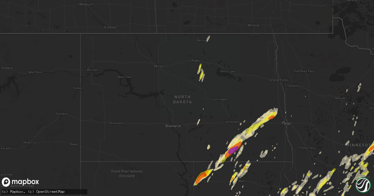
Hail Map in North Dakota on September 19, 2017
Get this storm
September 19 map
$229
one time, instant access
Download today. No call, no setup
Keep the $229
Bought the map and want the full workflow? Apply the entire $229 to a subscription within 7 days. None of it is wasted.
Every map, not just this one
This buys you this map. Subscription and you get every map we run, in the markets you choose from a few cities to whole states to nationwide. Plus real-time alerts the moment a storm fires.
Contact data
Name, contact info, occupancy, even credit band for addresses in the footprint. You go from where it hit to who to call.
Become the source they trust
Unlimited branding weather history reports on demand. You already have the documented answer ready for the property owner, and you are the one who showed up with it.
Property data and RoofTrace estimates
Pull up any address you have got, its value and the exact code rules for that jurisdiction, straight from One Click Code. Then RoofTrace estimates the squares, pitch, and roof value, priced the way you price.
Storm reports in North Dakota
North Dakota
| Date | Description |
|---|---|
| 09/19/20176:55 PM CDT | A local report indicates 1.00 inch wind near 2 N ESMOND |
| 09/19/20176:25 PM CDT | Cellular communications tower received damage to mounted transmitter and receiver platforms. Technician estimates winds in excess of 80 mph required to produce the dama |
| 09/19/20176:17 PM CDT | Facebook report indicating numerous large branches scattered all over the road for around one eigth of a mile half way between page and gardner on county road 26. Branc |
| 09/19/20175:45 PM CDT | Strong winds with pea size hail. |
| 09/19/20174:56 PM CDT | A few large tree branches were broken down in shelter belts just south of highway 46... In far northwest northland township. Time estimated based on radar. |
| 09/19/20174:41 PM CDT | The tornado tracked eastward for nearly 4 miles and ended about 1 sw of hastings by 447 pm cdt. The tornado peeled shingles and roofing off of homes at two farmsteads r |
| 09/19/20174:41 PM CDT | Barn had damage to roof with tree limbs in roof. House had shingles removed. |
| 09/19/20174:30 PM CDT | Quarter sized hail accompanied by 50 to 60 mph winds. |
| 09/19/20174:22 PM CDT | Roof blown off machine shed. Delayed report. |
| 09/19/20174:05 PM CDT | Hail observed at time of call. |
| 09/19/20174:01 PM CDT | Hail was falling at the time of the call. |
| 09/19/20173:53 PM CDT | Damage to a windshield and two house windows. |
| 09/19/20173:52 PM CDT | A local report indicates 2.50 inch wind near 3 NNW MONANGO |
| 09/19/20173:30 PM CDT | This is a delayed report. |
| 09/18/20179:45 PM CDT | A few large 4 to 6 inch diamter tree branches and limbs broken down around town. |
| 09/18/20179:07 PM CDT | Time estimated from radar. |
All States Impacted by Hail Map on September 19, 2017
Cities Impacted by Hail Map on September 19, 2017
- Newcastle, TX
- Throckmorton, TX
- Iowa Park, TX
- Hunter, ND
- Erie, ND
- Tower City, ND
- Amenia, ND
- Arthur, ND
- Ayr, ND
- Wheatland, ND
- Buffalo, ND
- Absaraka, ND
- Oriska, ND
- Jacksboro, TX
- Bowie, TX
- Litchville, ND
- Marion, ND
- Sonora, TX
- London, TX
- Roosevelt, TX
- Junction, TX
- Barnum, MN
- Cloquet, MN
- Pierz, MN
- Clinton, MN
- Ortonville, MN
- Twin Brooks, SD
- Stockholm, SD
- Marvin, SD
- South Shore, SD
- Ipswich, SD
- Aberdeen, SD
- Onamia, MN
- Brainerd, MN
- Aitkin, MN
- Hillman, MN
- Garrison, MN
- Wessington Springs, SD
- Glidden, WI
- Windthorst, TX
- Perrin, TX
- Saint Cloud, MN
- Henrietta, TX
- Bellevue, TX
- Electra, TX
- Holliday, TX
- Big Stone City, SD
- Milbank, SD
- Mason, WI
- Hayward, WI
- Cable, WI
- Clam Lake, WI
- Marengo, WI
- Voss, TX
- Gouldbusk, TX
- Coleman, TX
- Solon Springs, WI
- Iroquois, SD
- Murdock, MN
- Sunburg, MN
- Page, ND
- Cass Lake, MN
- Swanville, MN
- Glenwood, MN
- Benson, MN
- Starbuck, MN
- Little Falls, MN
- Burtrum, MN
- Danbury, WI
- Lewisburg, TN
- Lamoure, ND
- Fullerton, ND
- Mansfield, SD
- Huron, SD
- Platte, SD
- Kimball, SD
- Wahkon, MN
- Isle, MN
- Ogilvie, MN
- Mora, MN
- Mason, TX
- Raymond, SD
- Doland, SD
- Nashville, TN
- Brentwood, TN
- Plankinton, SD
- Oakes, ND
- Frankfort, SD
- Hitchcock, SD
- Letcher, SD
- May, TX
- Tamarack, MN
- Wright, MN
- Wichita Falls, TX
- Star Prairie, WI
- New Richmond, WI
- Kathryn, ND
- Edgeley, ND
- Seymour, TX
- Esmond, ND
- Maddock, ND
- Anniston, AL
- Dallas, SD
- Randlett, OK
- Brandt, SD
- Gary, SD
- Sanborn, ND
- Granite Falls, MN
- Orrville, AL
- Lake Andes, SD
- Geddes, SD
- Ohatchee, AL
- Ragland, AL
- Lincoln, AL
- Plum City, WI
- Royalton, MN
- Foley, MN
- Rice, MN
- Loveland, OK
- Berlin, ND
- Gregory, SD
- Bonesteel, SD
- McGrath, MN
- Artesian, SD
- Alpena, SD
- Woonsocket, SD
- Cavour, SD
- Paynesville, MN
- Mount Vernon, SD
- Corona, SD
- Wyndmere, ND
- Devol, OK
- Grandfield, OK
- Frederick, OK
- Hollister, OK
- Boyd, MN
- Dawson, MN
- Brook Park, MN
- Finlayson, MN
- Mills, NE
- Springview, NE
- Sauk Centre, MN
- Villard, MN
- Castlewood, SD
- Mellen, WI
- Richmond, MN
- Albany, MN
- Saint Martin, MN
- Columbia, SD
- Houghton, SD
- Frederick, SD
- Westport, SD
- Holyoke, MN
- Avon, MN
- Danvers, MN
- Lake Norden, SD
- Ellendale, ND
- Java, SD
- Bowdle, SD
- Eureka, SD
- Watkins, MN
- Eden Valley, MN
- Montevideo, MN
- Watson, MN
- Clitherall, MN
- Vining, MN
- Evansville, MN
- New London, MN
- Spicer, MN
- Saint Joseph, MN
- Tallassee, AL
- Eclectic, AL
- Askov, MN
- South Range, WI
- Superior, WI
- Pequot Lakes, MN
- Pine River, MN
- Ogema, WI
- Grey Eagle, MN
- White Lake, SD
- Florence, SD
- Wallace, SD
- Milnor, ND
- Tuskegee, AL
- Brownwood, TX
- Chokio, MN
- Morris, MN
- Echo, MN
- Tulare, SD
- Fort Ripley, MN
- Waite Park, MN
- Cushing, MN
- Sartell, MN
- Bowlus, MN
- Cold Spring, MN
- Randall, MN
- Sauk Rapids, MN
- Holdingford, MN
- Orlinda, TN
- Cross Plains, TN
- Portland, TN
- Mellette, SD
- Archer City, TX
- Sawyerville, AL
- Burke, SD
- Maple Grove, MN
- Hamel, MN
- Robinson, ND
- Arlington, SD
- Forbes, ND
- Kulm, ND
- Long Lake, SD
- Dickey, ND
- Ashley, ND
- Hosmer, SD
- White, SD
- Fedora, SD
- Heflin, AL
- Kerrick, MN
- Sturgeon Lake, MN
- Moose Lake, MN
- Hayti, SD
- Springbrook, WI
- Spooner, WI
- Selby, SD
- Milan, MN
- Madison, MN
- Sheppard Afb, TX
- Fairfax, SD
- Longville, MN
- Hackensack, MN
- Backus, MN
- Stacy, MN
- Chisago City, MN
- Lindstrom, MN
- North Branch, MN
- Center City, MN
- Hinckley, MN
- Carthage, SD
- Appleton, MN
- Lidgerwood, ND
- Town Creek, AL
- Hecla, SD
- Minneapolis, MN
- Arkansaw, WI
- Pennock, MN
- Kerkhoven, MN
- Bellingham, MN
- Revillo, SD
- Marietta, MN
- Walker, MN
- Renville, MN
- Sacred Heart, MN
- Lehr, ND
- Wishek, ND
- Stickney, SD
- Prior Lake, MN
- Savage, MN
- Shakopee, MN
- Saint Charles, SD
- Herrick, SD
- Melrose, MN
- Freeport, MN
- Menomonie, WI
- Fingal, ND
- Valley City, ND
- Carlton, MN
- Esko, MN
- Ramona, SD
- Nunda, SD
- Northville, SD
- Ashton, SD
- Laceys Spring, AL
- Sarona, WI
- Birchwood, WI
- Duluth, MN
- Wrenshall, MN
- Saint Croix Falls, WI
- Grantsburg, WI
- Northfield, MN
- Dundas, MN
- Holloway, MN
- Mcgregor, MN
- Shafer, MN
- San Saba, TX
- Nome, ND
- Fort Ransom, ND
- Stratford, SD
- Scotland, TX
- Maiden Rock, WI
- Fargo, ND
- Tenstrike, MN
- Hines, MN
- Goodwin, SD
- Eutaw, AL
- Akron, AL
- Forkland, AL
- Boligee, AL
- Phillips, WI
- McLain, MS
- Rugby, ND
- Long Prairie, MN
- Sandstone, MN
- Olney, TX
- Brookston, MN
- Durand, WI
- Browerville, MN
- Clarissa, MN
- Enderlin, ND
- Rutland, ND
- Cogswell, ND
- Leola, SD
- Atwater, MN
- Lake Lillian, MN
- Steele, ND
- Osseo, MN
- Mercer, WI
- Estelline, SD
- Drummond, WI
- Grove City, MN
- Watertown, SD
- Pillager, MN
- Motley, MN
- Staples, MN
- Osceola, WI
- De Smet, SD
- Sawyer, MN
- Saginaw, MN
- Greenwood, WI
- Willard, WI
- Rutland, SD
- Winter, WI
- Glen Flora, WI
- Hendricks, MN
- Canby, MN
- Fertile, MN
- Barrett, MN
- Cotton, MN
- Iron River, WI
- Bruce, SD
- Farmington, MN
- Davidson, OK
- Milaca, MN
- Winger, MN
- Richland Springs, TX
- Mullin, TX
- Rochelle, TX
- Menard, TX
- Strandburg, SD
- Rolla, ND
- Minong, WI
- Lakeville, MN
- Brookings, SD
- Webster, MN
- Harris, MN
- Blackduck, MN
- Hopkins, MN
- Howard, SD
- Squaw Lake, MN
- Medford, WI
- Westboro, WI
- Clear Lake, SD
- Kandiyohi, MN
- Lake Nebagamon, WI
- Poplar, WI
- Ypsilanti, ND
- Eden Prairie, MN
- Minnetonka, MN
- Odessa, MN
- Cornell, WI
- Glenpool, OK
- Rice Lake, WI
- Haugen, WI
- Guntersville, AL
- Belgrade, MN
- Bridgeport, TX
- Abilene, TX
- Corsica, SD
- Hazel, SD
- Chapel Hill, TN
- Leighton, AL
- Gilman, WI
- Taylors Falls, MN
- Dresser, WI
- Park Falls, WI
- Cushing, OK
- Mitchell, SD
- Menahga, MN
- Sebeka, MN
- Brooten, MN
- Alexandria, SD
- Spiritwood, ND
- Minocqua, WI
- Floodwood, MN
- Stone Lake, WI
- Cromwell, MN
- Catherine, AL
- Mathews, AL
- Russellville, AL
- Mount Hope, AL
- Mounds, OK
- Sapulpa, OK
- Chanhassen, MN
- Flensburg, MN
- Upsala, MN
- Canova, SD
- Bryant, SD
- Erwin, SD
- Chaska, MN
- Sweetwater, TX
- Garden City, SD
- Bath, SD
- Albany, TX
- Anson, TX
- Arab, AL
- Wetumpka, AL
- Rocksprings, TX
- Georgetown, MN
- Burkburnett, TX
- Cottontown, TN
- Odenville, AL
- Ashville, AL
- Litchfield, MN
- Roscoe, MN
- Foxboro, WI
- Fifield, WI
- Circle Pines, MN
- Northome, MN
- Albertville, AL
- Kettle River, MN
- Alborn, MN
- Rockwood, TX
- Cullman, AL
- Hanceville, AL
- Walters, OK
- Forest Lake, MN
- Wyoming, MN
- Aurora, SD
- Clontarf, MN
- Columbia, TN
- Ashland City, TN
- Cyrus, MN
- Hancock, MN
- Lublin, WI
- Gwinner, ND
- Forman, ND
- Summit, SD
- Carver, MN
- Carpenter, SD
- Clark, SD
- Amboy, WA
- Ivanhoe, MN
- Porter, MN
- Felton, MN
- Franklin, TN
- Alberta, MN
- Donnelly, MN
- Hector, MN
- Montpelier, ND
- Fredonia, ND
- Galesburg, ND
- Jud, ND
- Madison, SD
- Correll, MN
- Harvey, ND
- Saint Stephen, MN


