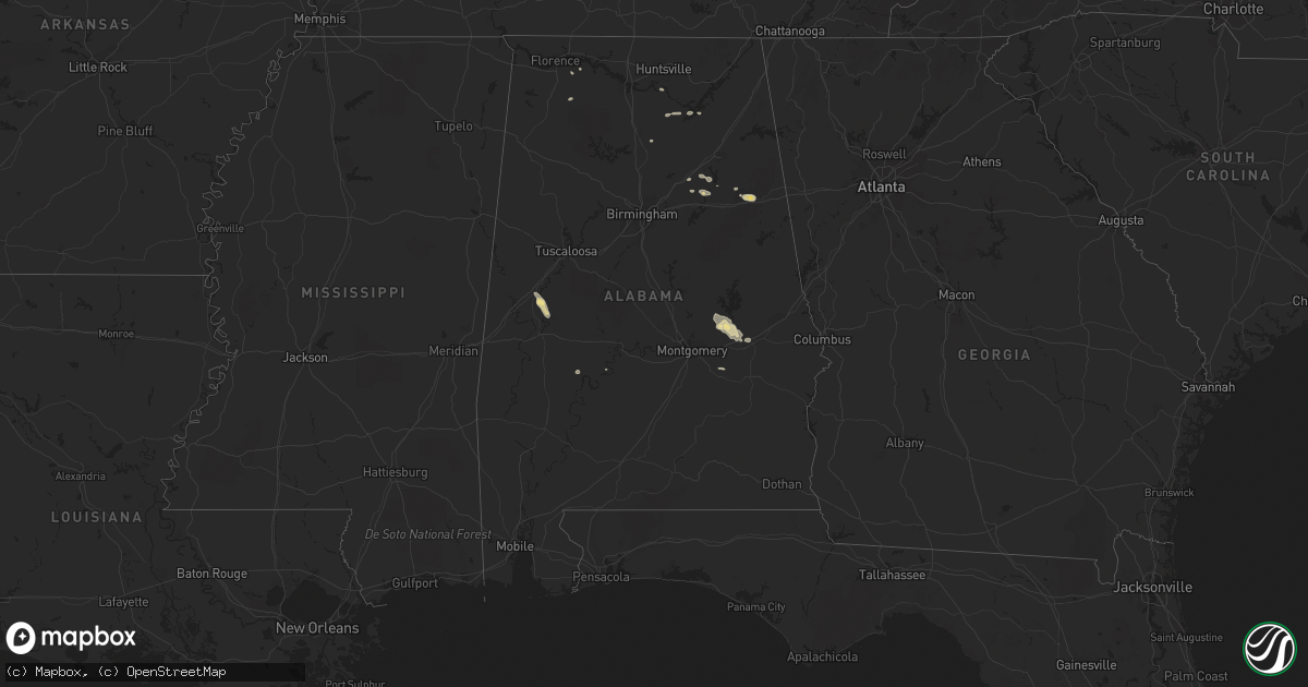
Hail Map in Alabama on September 19, 2017
Get this storm
September 19 map
$229
one time, instant access
Download today. No call, no setup
Keep the $229
Bought the map and want the full workflow? Apply the entire $229 to a subscription within 7 days. None of it is wasted.
Every map, not just this one
This buys you this map. Subscription and you get every map we run, in the markets you choose from a few cities to whole states to nationwide. Plus real-time alerts the moment a storm fires.
Contact data
Name, contact info, occupancy, even credit band for addresses in the footprint. You go from where it hit to who to call.
Become the source they trust
Unlimited branding weather history reports on demand. You already have the documented answer ready for the property owner, and you are the one who showed up with it.
Property data and RoofTrace estimates
Pull up any address you have got, its value and the exact code rules for that jurisdiction, straight from One Click Code. Then RoofTrace estimates the squares, pitch, and roof value, priced the way you price.
Storm reports in Alabama
Alabama
| Date | Description |
|---|---|
| 09/19/20176:51 PM CDT | Tree down across the roadway. |
| 09/19/20176:50 PM CDT | Tree down across the roadway. *corrected time. |
| 09/19/20176:50 PM CDT | Tree down with power line damage/arcing. |
| 09/19/20176:49 PM CDT | Tree down in the roadway at brookley drive and old salem road. |
| 09/19/20176:47 PM CDT | Tree down across the roadway. |
| 09/19/20176:45 PM CDT | Tree down in the roadway. |
| 09/19/20176:32 PM CDT | Tree down in the roadway. |
| 09/19/20175:00 PM CDT | Tree downed along highway 9. Time estimated. |
| 09/19/20175:00 PM CDT | Trees fell onto a mobile home causing visible roof damage. Time and location approximate. |
| 09/19/20174:59 PM CDT | Tree downed on downing mill road. |
| 09/19/20174:57 PM CDT | Tree downed along highway 78. Time estimated. |
| 09/19/20174:57 PM CDT | Tree downed at riddle farm road and old downing mill road. Time estimated. |
| 09/19/20174:57 PM CDT | Trained spotter shared video from choccolocco community church of quarter sized hail accumulating. |
| 09/19/20174:06 PM CDT | Tree downed at mudd street and sulpher springs road. Time estimated. |
| 09/19/20173:03 PM CDT | A 50 mph gust was measured on cr 54 east of geraldine. |
| 09/19/20172:28 PM CDT | Two trees were reported down in the pleasant grove area. |
| 09/19/20172:28 PM CDT | Two trees down in the pleasant grove area. |
| 09/19/20172:28 PM CDT | Widespread power outages reported in the guntersville area. |
| 09/19/20171:58 PM CDT | Power lines down on eddy scant road. |
| 09/19/201711:07 AM CDT | Gust reported by asos of 59 mph. |
| 09/19/201711:06 AM CDT | Gust reported by asos of 59 mph. |
| 09/18/20177:12 PM CDT | Tree down across the roadway. |
All States Impacted by Hail Map on September 19, 2017
Cities Impacted by Hail Map on September 19, 2017
- Newcastle, TX
- Throckmorton, TX
- Iowa Park, TX
- Hunter, ND
- Erie, ND
- Tower City, ND
- Amenia, ND
- Arthur, ND
- Ayr, ND
- Wheatland, ND
- Buffalo, ND
- Absaraka, ND
- Oriska, ND
- Jacksboro, TX
- Bowie, TX
- Litchville, ND
- Marion, ND
- Sonora, TX
- London, TX
- Roosevelt, TX
- Junction, TX
- Barnum, MN
- Cloquet, MN
- Pierz, MN
- Clinton, MN
- Ortonville, MN
- Twin Brooks, SD
- Stockholm, SD
- Marvin, SD
- South Shore, SD
- Ipswich, SD
- Aberdeen, SD
- Onamia, MN
- Brainerd, MN
- Aitkin, MN
- Hillman, MN
- Garrison, MN
- Wessington Springs, SD
- Glidden, WI
- Windthorst, TX
- Perrin, TX
- Saint Cloud, MN
- Henrietta, TX
- Bellevue, TX
- Electra, TX
- Holliday, TX
- Big Stone City, SD
- Milbank, SD
- Mason, WI
- Hayward, WI
- Cable, WI
- Clam Lake, WI
- Marengo, WI
- Voss, TX
- Gouldbusk, TX
- Coleman, TX
- Solon Springs, WI
- Iroquois, SD
- Murdock, MN
- Sunburg, MN
- Page, ND
- Cass Lake, MN
- Swanville, MN
- Glenwood, MN
- Benson, MN
- Starbuck, MN
- Little Falls, MN
- Burtrum, MN
- Danbury, WI
- Lewisburg, TN
- Lamoure, ND
- Fullerton, ND
- Mansfield, SD
- Huron, SD
- Platte, SD
- Kimball, SD
- Wahkon, MN
- Isle, MN
- Ogilvie, MN
- Mora, MN
- Mason, TX
- Raymond, SD
- Doland, SD
- Nashville, TN
- Brentwood, TN
- Plankinton, SD
- Oakes, ND
- Frankfort, SD
- Hitchcock, SD
- Letcher, SD
- May, TX
- Tamarack, MN
- Wright, MN
- Wichita Falls, TX
- Star Prairie, WI
- New Richmond, WI
- Kathryn, ND
- Edgeley, ND
- Seymour, TX
- Esmond, ND
- Maddock, ND
- Anniston, AL
- Dallas, SD
- Randlett, OK
- Brandt, SD
- Gary, SD
- Sanborn, ND
- Granite Falls, MN
- Orrville, AL
- Lake Andes, SD
- Geddes, SD
- Ohatchee, AL
- Ragland, AL
- Lincoln, AL
- Plum City, WI
- Royalton, MN
- Foley, MN
- Rice, MN
- Loveland, OK
- Berlin, ND
- Gregory, SD
- Bonesteel, SD
- McGrath, MN
- Artesian, SD
- Alpena, SD
- Woonsocket, SD
- Cavour, SD
- Paynesville, MN
- Mount Vernon, SD
- Corona, SD
- Wyndmere, ND
- Devol, OK
- Grandfield, OK
- Frederick, OK
- Hollister, OK
- Boyd, MN
- Dawson, MN
- Brook Park, MN
- Finlayson, MN
- Mills, NE
- Springview, NE
- Sauk Centre, MN
- Villard, MN
- Castlewood, SD
- Mellen, WI
- Richmond, MN
- Albany, MN
- Saint Martin, MN
- Columbia, SD
- Houghton, SD
- Frederick, SD
- Westport, SD
- Holyoke, MN
- Avon, MN
- Danvers, MN
- Lake Norden, SD
- Ellendale, ND
- Java, SD
- Bowdle, SD
- Eureka, SD
- Watkins, MN
- Eden Valley, MN
- Montevideo, MN
- Watson, MN
- Clitherall, MN
- Vining, MN
- Evansville, MN
- New London, MN
- Spicer, MN
- Saint Joseph, MN
- Tallassee, AL
- Eclectic, AL
- Askov, MN
- South Range, WI
- Superior, WI
- Pequot Lakes, MN
- Pine River, MN
- Ogema, WI
- Grey Eagle, MN
- White Lake, SD
- Florence, SD
- Wallace, SD
- Milnor, ND
- Tuskegee, AL
- Brownwood, TX
- Chokio, MN
- Morris, MN
- Echo, MN
- Tulare, SD
- Fort Ripley, MN
- Waite Park, MN
- Cushing, MN
- Sartell, MN
- Bowlus, MN
- Cold Spring, MN
- Randall, MN
- Sauk Rapids, MN
- Holdingford, MN
- Orlinda, TN
- Cross Plains, TN
- Portland, TN
- Mellette, SD
- Archer City, TX
- Sawyerville, AL
- Burke, SD
- Maple Grove, MN
- Hamel, MN
- Robinson, ND
- Arlington, SD
- Forbes, ND
- Kulm, ND
- Long Lake, SD
- Dickey, ND
- Ashley, ND
- Hosmer, SD
- White, SD
- Fedora, SD
- Heflin, AL
- Kerrick, MN
- Sturgeon Lake, MN
- Moose Lake, MN
- Hayti, SD
- Springbrook, WI
- Spooner, WI
- Selby, SD
- Milan, MN
- Madison, MN
- Sheppard Afb, TX
- Fairfax, SD
- Longville, MN
- Hackensack, MN
- Backus, MN
- Stacy, MN
- Chisago City, MN
- Lindstrom, MN
- North Branch, MN
- Center City, MN
- Hinckley, MN
- Carthage, SD
- Appleton, MN
- Lidgerwood, ND
- Town Creek, AL
- Hecla, SD
- Minneapolis, MN
- Arkansaw, WI
- Pennock, MN
- Kerkhoven, MN
- Bellingham, MN
- Revillo, SD
- Marietta, MN
- Walker, MN
- Renville, MN
- Sacred Heart, MN
- Lehr, ND
- Wishek, ND
- Stickney, SD
- Prior Lake, MN
- Savage, MN
- Shakopee, MN
- Saint Charles, SD
- Herrick, SD
- Melrose, MN
- Freeport, MN
- Menomonie, WI
- Fingal, ND
- Valley City, ND
- Carlton, MN
- Esko, MN
- Ramona, SD
- Nunda, SD
- Northville, SD
- Ashton, SD
- Laceys Spring, AL
- Sarona, WI
- Birchwood, WI
- Duluth, MN
- Wrenshall, MN
- Saint Croix Falls, WI
- Grantsburg, WI
- Northfield, MN
- Dundas, MN
- Holloway, MN
- Mcgregor, MN
- Shafer, MN
- San Saba, TX
- Nome, ND
- Fort Ransom, ND
- Stratford, SD
- Scotland, TX
- Maiden Rock, WI
- Fargo, ND
- Tenstrike, MN
- Hines, MN
- Goodwin, SD
- Eutaw, AL
- Akron, AL
- Forkland, AL
- Boligee, AL
- Phillips, WI
- McLain, MS
- Rugby, ND
- Long Prairie, MN
- Sandstone, MN
- Olney, TX
- Brookston, MN
- Durand, WI
- Browerville, MN
- Clarissa, MN
- Enderlin, ND
- Rutland, ND
- Cogswell, ND
- Leola, SD
- Atwater, MN
- Lake Lillian, MN
- Steele, ND
- Osseo, MN
- Mercer, WI
- Estelline, SD
- Drummond, WI
- Grove City, MN
- Watertown, SD
- Pillager, MN
- Motley, MN
- Staples, MN
- Osceola, WI
- De Smet, SD
- Sawyer, MN
- Saginaw, MN
- Greenwood, WI
- Willard, WI
- Rutland, SD
- Winter, WI
- Glen Flora, WI
- Hendricks, MN
- Canby, MN
- Fertile, MN
- Barrett, MN
- Cotton, MN
- Iron River, WI
- Bruce, SD
- Farmington, MN
- Davidson, OK
- Milaca, MN
- Winger, MN
- Richland Springs, TX
- Mullin, TX
- Rochelle, TX
- Menard, TX
- Strandburg, SD
- Rolla, ND
- Minong, WI
- Lakeville, MN
- Brookings, SD
- Webster, MN
- Harris, MN
- Blackduck, MN
- Hopkins, MN
- Howard, SD
- Squaw Lake, MN
- Medford, WI
- Westboro, WI
- Clear Lake, SD
- Kandiyohi, MN
- Lake Nebagamon, WI
- Poplar, WI
- Ypsilanti, ND
- Eden Prairie, MN
- Minnetonka, MN
- Odessa, MN
- Cornell, WI
- Glenpool, OK
- Rice Lake, WI
- Haugen, WI
- Guntersville, AL
- Belgrade, MN
- Bridgeport, TX
- Abilene, TX
- Corsica, SD
- Hazel, SD
- Chapel Hill, TN
- Leighton, AL
- Gilman, WI
- Taylors Falls, MN
- Dresser, WI
- Park Falls, WI
- Cushing, OK
- Mitchell, SD
- Menahga, MN
- Sebeka, MN
- Brooten, MN
- Alexandria, SD
- Spiritwood, ND
- Minocqua, WI
- Floodwood, MN
- Stone Lake, WI
- Cromwell, MN
- Catherine, AL
- Mathews, AL
- Russellville, AL
- Mount Hope, AL
- Mounds, OK
- Sapulpa, OK
- Chanhassen, MN
- Flensburg, MN
- Upsala, MN
- Canova, SD
- Bryant, SD
- Erwin, SD
- Chaska, MN
- Sweetwater, TX
- Garden City, SD
- Bath, SD
- Albany, TX
- Anson, TX
- Arab, AL
- Wetumpka, AL
- Rocksprings, TX
- Georgetown, MN
- Burkburnett, TX
- Cottontown, TN
- Odenville, AL
- Ashville, AL
- Litchfield, MN
- Roscoe, MN
- Foxboro, WI
- Fifield, WI
- Circle Pines, MN
- Northome, MN
- Albertville, AL
- Kettle River, MN
- Alborn, MN
- Rockwood, TX
- Cullman, AL
- Hanceville, AL
- Walters, OK
- Forest Lake, MN
- Wyoming, MN
- Aurora, SD
- Clontarf, MN
- Columbia, TN
- Ashland City, TN
- Cyrus, MN
- Hancock, MN
- Lublin, WI
- Gwinner, ND
- Forman, ND
- Summit, SD
- Carver, MN
- Carpenter, SD
- Clark, SD
- Amboy, WA
- Ivanhoe, MN
- Porter, MN
- Felton, MN
- Franklin, TN
- Alberta, MN
- Donnelly, MN
- Hector, MN
- Montpelier, ND
- Fredonia, ND
- Galesburg, ND
- Jud, ND
- Madison, SD
- Correll, MN
- Harvey, ND
- Saint Stephen, MN


