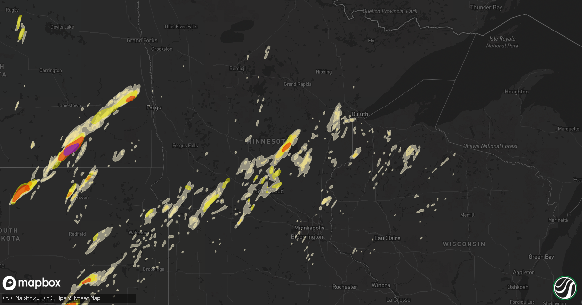
Hail Map in Minnesota on September 19, 2017
Get this storm
September 19 map
$229
one time, instant access
Download today. No call, no setup
Keep the $229
Bought the map and want the full workflow? Apply the entire $229 to a subscription within 7 days. None of it is wasted.
Every map, not just this one
This buys you this map. Subscription and you get every map we run, in the markets you choose from a few cities to whole states to nationwide. Plus real-time alerts the moment a storm fires.
Contact data
Name, contact info, occupancy, even credit band for addresses in the footprint. You go from where it hit to who to call.
Become the source they trust
Unlimited branding weather history reports on demand. You already have the documented answer ready for the property owner, and you are the one who showed up with it.
Property data and RoofTrace estimates
Pull up any address you have got, its value and the exact code rules for that jurisdiction, straight from One Click Code. Then RoofTrace estimates the squares, pitch, and roof value, priced the way you price.
Storm reports in Minnesota
Minnesota
| Date | Description |
|---|---|
| 09/19/20173:42 AM CDT | Tree across roadway at highway 21 and shaver road. Time estimated by radar. |
| 09/19/20173:24 AM CDT | Tree down blocking mn-169 in breitung township near soudan. Time estimated by radar. |
| 09/19/20173:22 AM CDT | Tree down crossing eshquaguma country road off of vermilion trail. Time estimated by radar. |
| 09/19/20173:22 AM CDT | A few 5 to 6 inch diameter branches downed. Time estimated by radar. |
| 09/19/20173:06 AM CDT | Several trees down blocking old mesabi road in clinton township. Time estimated by radar. |
| 09/19/20173:03 AM CDT | A 12 to 18 inch diameter branch down which was partially blocking road on grant avenue. Time estimated by radar. |
| 09/19/20172:43 AM CDT | A few 10 inch diameter trees down on mn-27 near mn-73. Time estimated by radar. |
| 09/19/20172:42 AM CDT | Several large trees downed... Which fell onto a home damaging the chimney and siding of the home. Time estimated from radar. |
| 09/19/20172:35 AM CDT | Few trees down on county road 41 near willow river. Time estimated by radar. |
| 09/19/20172:31 AM CDT | Trees down on state highway 65 near buck lake. Time estimated by radar. |
| 09/19/20172:30 AM CDT | Time estimated by radar. |
| 09/19/20172:24 AM CDT | Trees down on mn-38 in marcell. Time estimated by radar. |
| 09/19/20172:15 AM CDT | Trees uprooted and branch fell on car. |
| 09/19/20172:03 AM CDT | Multiple trees down. Time estimated from radar. |
| 09/19/20172:02 AM CDT | A local report indicates 1.75 inch wind near 3 NNW VINELAND |
| 09/19/20172:02 AM CDT | A local report indicates 1.00 inch wind near SARTELL |
| 09/19/20172:00 AM CDT | Multiple trees down on county 63 in boy river township. Time estimated by radar. |
| 09/19/20171:56 AM CDT | Multiple trees down on county road 8 in boy lake township. Time estimated by radar. |
| 09/19/20171:55 AM CDT | Trees down on power lines. |
| 09/19/20171:53 AM CDT | Hail began approx 153 am and was still falling when spotter called at 158 am. |
| 09/19/20171:52 AM CDT | Multiple trees down on county road 7 in trelipe township. Time estimated by radar. |
| 09/19/20171:48 AM CDT | Multiple trees and power lines downed. Time estimated from radar. |
| 09/19/20171:45 AM CDT | Multiple trees and power lines downed. Time estimated from radar. |
| 09/19/20171:43 AM CDT | Mesonet station c8652... 2 ne jenkins. |
| 09/19/20171:42 AM CDT | Multiple trees and power lines downed. Time estimated from radar. |
| 09/19/20171:39 AM CDT | Multiple trees downed on county road 145 in jenkins. Time estimated from radar. |
| 09/19/20171:38 AM CDT | Multiple trees downed with the largest tree being 20 inches in diameter. Time estimated from radar. |
| 09/19/20171:37 AM CDT | Multiple trees and power lines downed. Time estimated from radar. |
| 09/19/20171:35 AM CDT | Lots of trees knocked down in the lake shore area. Time estimated by radar. |
| 09/19/20171:31 AM CDT | Several 12+ inch diameter pine and oak trees blown down on mn-210 approximately 2 miles west of mn-371. In addition... An oak tree is laying across a home on the south |
| 09/19/20171:21 AM CDT | A local report indicates 1.00 inch wind near 2 SW BOWLUS |
| 09/19/20171:20 AM CDT | Boat and attached dock on long lake detached from shoreline and was blown into another dock. Several trees down on properties along ne shoreline. Damage to roof of home |
| 09/19/20171:15 AM CDT | Trees down and building damage. Reports from public via facebook include photos of damage. Time is estimated. |
| 09/19/201712:48 AM CDT | Numerous large trees and power lines down throughout the city of belgrade. |
| 09/19/201712:41 AM CDT | A local report indicates 59 MPH wind near CLARA CITY |
| 09/19/201712:40 AM CDT | Large tree down on hwy 104 about 2 miles south of co rd 8 intersection. Reported via twitter. Time estimated. |
| 09/19/201712:33 AM CDT | Grain bins and sheds damaged. Possible tornado. |
| 09/19/201712:30 AM CDT | In swift falls on cr 31. |
| 09/19/201712:30 AM CDT | Numerous trees down around town. At least one tree fell on a house. Time estimated from radar. |
| 09/19/201712:25 AM CDT | A few large 4 to 6 inch tree branches broken down in groves and shelter belts across east central henning township. |
| 09/19/201712:22 AM CDT | Tree damage reported on the northwesterly side of camp lake. A turkey barn's roof at jennie-o indian hills farm was taken southwest of camp lake. Barns down and roofs o |
| 09/19/201712:20 AM CDT | Several pine trees snapped... Some blocking roads... North of brandon near co. Rd. 7 and big chip rd. Time estimated by radar. |
| 09/19/201712:15 AM CDT | City manager reports damage to several trees... And shingles and siding off a few buildings in town. Damage is near hwy 212 river crossing to near fairgrounds. Corn fie |
| 09/19/201712:11 AM CDT | Trees down in balaton. Report via social media. |
| 09/19/201712:02 AM CDT | A local report indicates 68 MPH wind near 2 S LUVERNE |
| 09/18/201711:59 PM CDT | Tree downed onto car. Report via social media. Time estimated from radar. |
| 09/18/201711:55 PM CDT | Large tree down on car. |
| 09/18/201711:55 PM CDT | Mndot rwis site at beaver creek. |
| 09/18/201711:54 PM CDT | A few large tree branches and limbs broken down around town. Peak winds measured at the elbow lake airport of 54 mph. |
| 09/18/201711:52 PM CDT | A local report indicates 1.00 inch wind near 1 WNW MORRIS |
| 09/18/201711:44 PM CDT | Trees snapped at jasper cemetery. Time estimated from radar. |
| 09/18/201711:40 PM CDT | Numerous large tree branches broken down near tulaby lake and elbow lake. Localized power outages caused by fallen branches knocking down power lines. |
| 09/18/201710:55 PM CDT | Numerous large tree branches broken down around cormorant lake with power lines knocked down and localized power outages. |
| 09/18/20179:35 PM CDT | Tree fell on car. Occurred during high winds to 60 mph on the north side of a complex of storms. |
| 09/18/20179:30 PM CDT | Measured by a mndot rwis sensor. |
| 09/18/20179:30 PM CDT | Gazebo demolished as evidenced by photographs provided via social media. Strong winds between 9 and 11 pm reported by responder. |
| 09/18/20179:15 PM CDT | Several felled trees and large limbs at responders residence and nearby. |
| 09/18/20179:05 PM CDT | Several large oak branches down in the yard. Some of the branches were 4 to 6 inches in diameter. |
| 09/18/20178:59 PM CDT | Kfse observation indicated wind gusts to 63 mph from the southwest. Local observers reported that shelter belts in adjacent portions of brandsvold township had broken o |
| 09/18/20178:59 PM CDT | Kfse observation indicated wind gusts to 63 mph from the southwest. |
| 09/18/20178:50 PM CDT | Numerous 4 to 6 inch diameter tree branches and limbs were broken down in shelter belts across southern poplar river township. The nearby rwis station lost power at thi |
| 09/18/20178:40 PM CDT | Photographic evidence of downed trees around responders farm. Oak tree uprooted. |
| 09/18/20177:50 PM CDT | The tornado tracked intermittently northward along the highway 9 corridor for about 4 miles and ended just past the community of beltrami by 801 pm cdt. As the nascent |
All States Impacted by Hail Map on September 19, 2017
Cities Impacted by Hail Map on September 19, 2017
- Newcastle, TX
- Throckmorton, TX
- Iowa Park, TX
- Hunter, ND
- Erie, ND
- Tower City, ND
- Amenia, ND
- Arthur, ND
- Ayr, ND
- Wheatland, ND
- Buffalo, ND
- Absaraka, ND
- Oriska, ND
- Jacksboro, TX
- Bowie, TX
- Litchville, ND
- Marion, ND
- Sonora, TX
- London, TX
- Roosevelt, TX
- Junction, TX
- Barnum, MN
- Cloquet, MN
- Pierz, MN
- Clinton, MN
- Ortonville, MN
- Twin Brooks, SD
- Stockholm, SD
- Marvin, SD
- South Shore, SD
- Ipswich, SD
- Aberdeen, SD
- Onamia, MN
- Brainerd, MN
- Aitkin, MN
- Hillman, MN
- Garrison, MN
- Wessington Springs, SD
- Glidden, WI
- Windthorst, TX
- Perrin, TX
- Saint Cloud, MN
- Henrietta, TX
- Bellevue, TX
- Electra, TX
- Holliday, TX
- Big Stone City, SD
- Milbank, SD
- Mason, WI
- Hayward, WI
- Cable, WI
- Clam Lake, WI
- Marengo, WI
- Voss, TX
- Gouldbusk, TX
- Coleman, TX
- Solon Springs, WI
- Iroquois, SD
- Murdock, MN
- Sunburg, MN
- Page, ND
- Cass Lake, MN
- Swanville, MN
- Glenwood, MN
- Benson, MN
- Starbuck, MN
- Little Falls, MN
- Burtrum, MN
- Danbury, WI
- Lewisburg, TN
- Lamoure, ND
- Fullerton, ND
- Mansfield, SD
- Huron, SD
- Platte, SD
- Kimball, SD
- Wahkon, MN
- Isle, MN
- Ogilvie, MN
- Mora, MN
- Mason, TX
- Raymond, SD
- Doland, SD
- Nashville, TN
- Brentwood, TN
- Plankinton, SD
- Oakes, ND
- Frankfort, SD
- Hitchcock, SD
- Letcher, SD
- May, TX
- Tamarack, MN
- Wright, MN
- Wichita Falls, TX
- Star Prairie, WI
- New Richmond, WI
- Kathryn, ND
- Edgeley, ND
- Seymour, TX
- Esmond, ND
- Maddock, ND
- Anniston, AL
- Dallas, SD
- Randlett, OK
- Brandt, SD
- Gary, SD
- Sanborn, ND
- Granite Falls, MN
- Orrville, AL
- Lake Andes, SD
- Geddes, SD
- Ohatchee, AL
- Ragland, AL
- Lincoln, AL
- Plum City, WI
- Royalton, MN
- Foley, MN
- Rice, MN
- Loveland, OK
- Berlin, ND
- Gregory, SD
- Bonesteel, SD
- McGrath, MN
- Artesian, SD
- Alpena, SD
- Woonsocket, SD
- Cavour, SD
- Paynesville, MN
- Mount Vernon, SD
- Corona, SD
- Wyndmere, ND
- Devol, OK
- Grandfield, OK
- Frederick, OK
- Hollister, OK
- Boyd, MN
- Dawson, MN
- Brook Park, MN
- Finlayson, MN
- Mills, NE
- Springview, NE
- Sauk Centre, MN
- Villard, MN
- Castlewood, SD
- Mellen, WI
- Richmond, MN
- Albany, MN
- Saint Martin, MN
- Columbia, SD
- Houghton, SD
- Frederick, SD
- Westport, SD
- Holyoke, MN
- Avon, MN
- Danvers, MN
- Lake Norden, SD
- Ellendale, ND
- Java, SD
- Bowdle, SD
- Eureka, SD
- Watkins, MN
- Eden Valley, MN
- Montevideo, MN
- Watson, MN
- Clitherall, MN
- Vining, MN
- Evansville, MN
- New London, MN
- Spicer, MN
- Saint Joseph, MN
- Tallassee, AL
- Eclectic, AL
- Askov, MN
- South Range, WI
- Superior, WI
- Pequot Lakes, MN
- Pine River, MN
- Ogema, WI
- Grey Eagle, MN
- White Lake, SD
- Florence, SD
- Wallace, SD
- Milnor, ND
- Tuskegee, AL
- Brownwood, TX
- Chokio, MN
- Morris, MN
- Echo, MN
- Tulare, SD
- Fort Ripley, MN
- Waite Park, MN
- Cushing, MN
- Sartell, MN
- Bowlus, MN
- Cold Spring, MN
- Randall, MN
- Sauk Rapids, MN
- Holdingford, MN
- Orlinda, TN
- Cross Plains, TN
- Portland, TN
- Mellette, SD
- Archer City, TX
- Sawyerville, AL
- Burke, SD
- Maple Grove, MN
- Hamel, MN
- Robinson, ND
- Arlington, SD
- Forbes, ND
- Kulm, ND
- Long Lake, SD
- Dickey, ND
- Ashley, ND
- Hosmer, SD
- White, SD
- Fedora, SD
- Heflin, AL
- Kerrick, MN
- Sturgeon Lake, MN
- Moose Lake, MN
- Hayti, SD
- Springbrook, WI
- Spooner, WI
- Selby, SD
- Milan, MN
- Madison, MN
- Sheppard Afb, TX
- Fairfax, SD
- Longville, MN
- Hackensack, MN
- Backus, MN
- Stacy, MN
- Chisago City, MN
- Lindstrom, MN
- North Branch, MN
- Center City, MN
- Hinckley, MN
- Carthage, SD
- Appleton, MN
- Lidgerwood, ND
- Town Creek, AL
- Hecla, SD
- Minneapolis, MN
- Arkansaw, WI
- Pennock, MN
- Kerkhoven, MN
- Bellingham, MN
- Revillo, SD
- Marietta, MN
- Walker, MN
- Renville, MN
- Sacred Heart, MN
- Lehr, ND
- Wishek, ND
- Stickney, SD
- Prior Lake, MN
- Savage, MN
- Shakopee, MN
- Saint Charles, SD
- Herrick, SD
- Melrose, MN
- Freeport, MN
- Menomonie, WI
- Fingal, ND
- Valley City, ND
- Carlton, MN
- Esko, MN
- Ramona, SD
- Nunda, SD
- Northville, SD
- Ashton, SD
- Laceys Spring, AL
- Sarona, WI
- Birchwood, WI
- Duluth, MN
- Wrenshall, MN
- Saint Croix Falls, WI
- Grantsburg, WI
- Northfield, MN
- Dundas, MN
- Holloway, MN
- Mcgregor, MN
- Shafer, MN
- San Saba, TX
- Nome, ND
- Fort Ransom, ND
- Stratford, SD
- Scotland, TX
- Maiden Rock, WI
- Fargo, ND
- Tenstrike, MN
- Hines, MN
- Goodwin, SD
- Eutaw, AL
- Akron, AL
- Forkland, AL
- Boligee, AL
- Phillips, WI
- McLain, MS
- Rugby, ND
- Long Prairie, MN
- Sandstone, MN
- Olney, TX
- Brookston, MN
- Durand, WI
- Browerville, MN
- Clarissa, MN
- Enderlin, ND
- Rutland, ND
- Cogswell, ND
- Leola, SD
- Atwater, MN
- Lake Lillian, MN
- Steele, ND
- Osseo, MN
- Mercer, WI
- Estelline, SD
- Drummond, WI
- Grove City, MN
- Watertown, SD
- Pillager, MN
- Motley, MN
- Staples, MN
- Osceola, WI
- De Smet, SD
- Sawyer, MN
- Saginaw, MN
- Greenwood, WI
- Willard, WI
- Rutland, SD
- Winter, WI
- Glen Flora, WI
- Hendricks, MN
- Canby, MN
- Fertile, MN
- Barrett, MN
- Cotton, MN
- Iron River, WI
- Bruce, SD
- Farmington, MN
- Davidson, OK
- Milaca, MN
- Winger, MN
- Richland Springs, TX
- Mullin, TX
- Rochelle, TX
- Menard, TX
- Strandburg, SD
- Rolla, ND
- Minong, WI
- Lakeville, MN
- Brookings, SD
- Webster, MN
- Harris, MN
- Blackduck, MN
- Hopkins, MN
- Howard, SD
- Squaw Lake, MN
- Medford, WI
- Westboro, WI
- Clear Lake, SD
- Kandiyohi, MN
- Lake Nebagamon, WI
- Poplar, WI
- Ypsilanti, ND
- Eden Prairie, MN
- Minnetonka, MN
- Odessa, MN
- Cornell, WI
- Glenpool, OK
- Rice Lake, WI
- Haugen, WI
- Guntersville, AL
- Belgrade, MN
- Bridgeport, TX
- Abilene, TX
- Corsica, SD
- Hazel, SD
- Chapel Hill, TN
- Leighton, AL
- Gilman, WI
- Taylors Falls, MN
- Dresser, WI
- Park Falls, WI
- Cushing, OK
- Mitchell, SD
- Menahga, MN
- Sebeka, MN
- Brooten, MN
- Alexandria, SD
- Spiritwood, ND
- Minocqua, WI
- Floodwood, MN
- Stone Lake, WI
- Cromwell, MN
- Catherine, AL
- Mathews, AL
- Russellville, AL
- Mount Hope, AL
- Mounds, OK
- Sapulpa, OK
- Chanhassen, MN
- Flensburg, MN
- Upsala, MN
- Canova, SD
- Bryant, SD
- Erwin, SD
- Chaska, MN
- Sweetwater, TX
- Garden City, SD
- Bath, SD
- Albany, TX
- Anson, TX
- Arab, AL
- Wetumpka, AL
- Rocksprings, TX
- Georgetown, MN
- Burkburnett, TX
- Cottontown, TN
- Odenville, AL
- Ashville, AL
- Litchfield, MN
- Roscoe, MN
- Foxboro, WI
- Fifield, WI
- Circle Pines, MN
- Northome, MN
- Albertville, AL
- Kettle River, MN
- Alborn, MN
- Rockwood, TX
- Cullman, AL
- Hanceville, AL
- Walters, OK
- Forest Lake, MN
- Wyoming, MN
- Aurora, SD
- Clontarf, MN
- Columbia, TN
- Ashland City, TN
- Cyrus, MN
- Hancock, MN
- Lublin, WI
- Gwinner, ND
- Forman, ND
- Summit, SD
- Carver, MN
- Carpenter, SD
- Clark, SD
- Amboy, WA
- Ivanhoe, MN
- Porter, MN
- Felton, MN
- Franklin, TN
- Alberta, MN
- Donnelly, MN
- Hector, MN
- Montpelier, ND
- Fredonia, ND
- Galesburg, ND
- Jud, ND
- Madison, SD
- Correll, MN
- Harvey, ND
- Saint Stephen, MN


