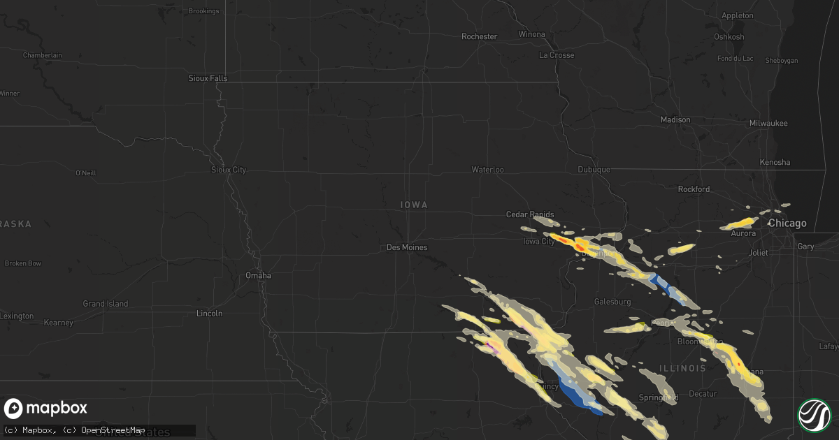
Hail Map in Iowa on September 18, 2022
Get this storm
September 18 map
$229
one time, instant access
Download today. No call, no setup
Keep the $229
Bought the map and want the full workflow? Apply the entire $229 to a subscription within 7 days. None of it is wasted.
Every map, not just this one
This buys you this map. Subscription and you get every map we run, in the markets you choose from a few cities to whole states to nationwide. Plus real-time alerts the moment a storm fires.
Contact data
Name, contact info, occupancy, even credit band for addresses in the footprint. You go from where it hit to who to call.
Become the source they trust
Unlimited branding weather history reports on demand. You already have the documented answer ready for the property owner, and you are the one who showed up with it.
Property data and RoofTrace estimates
Pull up any address you have got, its value and the exact code rules for that jurisdiction, straight from One Click Code. Then RoofTrace estimates the squares, pitch, and roof value, priced the way you price.
Storm reports in Iowa
Iowa
| Date | Description |
|---|---|
| 09/18/20226:32 AM CDT | At 1131 PM CDT, a severe thunderstorm was located over Galland, or near Nauvoo, moving southeast at 45 mph. HAZARD...60 mph wind gusts and quarter size hail. SOURCE...Radar indicated. IMPACT...Hail damage to vehicles is expected. Expect wind damage to roofs, siding, and trees. This severe thunderstorm will be near... Elvaston around 1140 PM CDT. Ferris and Adrian around 1145 PM CDT. Carthage and Burnside around 1150 PM CDT.Other locations in the path of this severe thunderstorm includeFountain Green, Bentley, Webster and Plymouth. |
| 09/18/20224:37 AM CDT | At 937 PM CDT, a severe thunderstorm was located over Sutter, or 8 miles southeast of Keokuk, moving east at 30 mph. HAZARD...60 mph wind gusts and quarter size hail. SOURCE...Radar indicated. IMPACT...Hail damage to vehicles is expected. Expect wind damage to roofs, siding, and trees. This severe thunderstorm will be near... West Point and Basco around 950 PM CDT. Bentley and Stillwell around 955 PM CDT.Other locations in the path of this severe thunderstorm includeDenver, Bowen, Augusta, Plymouth and Hancock County Fairgrounds. |
| 09/18/20224:29 AM CDT | At 928 PM CDT, a severe thunderstorm was located over Blue Grass, or 8 miles west of Davenport, moving southeast at 25 mph. HAZARD...Half dollar size hail. SOURCE...Radar indicated. IMPACT...Damage to vehicles is expected. This severe thunderstorm will be near... West Lake Park around 935 PM CDT. Buffalo and Andalusia around 940 PM CDT. Credit Island around 945 PM CDT.Other locations in the path of this severe thunderstorm include RockIsland, Milan, Oak Grove, Coyne Center, Blackhawk State Park, RockIsland Arsenal, Moline, Indian Bluff Golf Course, Moline Quad-CityAirport, Fruitland and Coal Valley. |
| 09/18/20224:15 AM CDT | At 915 PM CDT, a severe thunderstorm was located over Davenport, moving southeast at 40 mph. HAZARD...60 mph wind gusts. SOURCE...Radar indicated. IMPACT...Expect damage to roofs, siding, and trees. This severe thunderstorm will be near... Bettendorf around 920 PM CDT. Moline, Rock Island, Milan, Riverdale, Panorama Park, Rock Island Arsenal, Fruitland, Pleasant Valley and Blackhawk State Park around 925 PM CDT. East Moline, Silvis, Hampton, Carbon Cliff, Rock Island County Fairgrounds, Silvis Heights, Campbells Island, Moline Quad-City Airport, Indian Bluff Golf Course and Illiniwek Forest Preserve around 930 PM CDT. Colona, Coal Valley, Cleveland, Barstow and Sunny Hill Estates around 935 PM CDT.Other locations in the path of this severe thunderstorm includeWarner, Osborn, Dayton, Green River, Sunny Hill, Morristown and Osco. |
| 09/18/20223:58 AM CDT | At 857 PM CDT, a severe thunderstorm was located near Rochester, or 7 miles south of Tipton, moving east at 35 mph. Emergency management relayed a report of Quarter size hail in Rochester. HAZARD...Golf ball size hail and 60 mph wind gusts. SOURCE...Emergency management. IMPACT...People and animals outdoors will be injured. Expect hail damage to roofs, siding, windows, and vehicles. Expect wind damage to roofs, siding, and trees. This severe thunderstorm will be near... Wilton around 905 PM CDT. Sunbury around 910 PM CDT. Durant around 915 PM CDT.Other locations in the path of this severe thunderstorm includeStockton, Plainview, Maysville, Walcott and Blue Grass. |
| 09/18/20223:56 AM CDT | At 856 PM CDT, a severe thunderstorm was located 7 miles northwest of Queen City, or 7 miles west of Lancaster, moving southeast at 35 mph. HAZARD...60 mph wind gusts and quarter size hail. SOURCE...Radar indicated. IMPACT...Hail damage to vehicles is expected. Expect wind damage to roofs, siding, and trees. Locations impacted include... Lancaster, Queen City, Greentop, Downing, Glenwood, Worthington and Livonia. |
| 09/18/20223:34 AM CDT | At 833 PM CDT, a severe thunderstorm was located over Cedar Valley, or near West Branch, moving east at 40 mph. HAZARD...Half dollar size hail. SOURCE...Radar indicated. IMPACT...Damage to vehicles is expected. This severe thunderstorm will be near... Cedar County Fairgrounds around 840 PM CDT. Tipton, Rochester and Tipton Matthews Airport around 845 PM CDT.Other locations in the path of this severe thunderstorm includeBennett, Durant, Sunbury and Bennett Park. |
| 09/18/20223:20 AM CDT | At 820 PM CDT, a severe thunderstorm was located near Lancaster, moving east at 40 mph. HAZARD...60 mph wind gusts and quarter size hail. SOURCE...Radar indicated. IMPACT...Hail damage to vehicles is expected. Expect wind damage to roofs, siding, and trees. Locations impacted include... Lancaster, Downing and Glenwood. |
| 09/18/20223:08 AM CDT | At 808 PM CDT, a severe thunderstorm was located over Mechanicsville, moving east at 35 mph. HAZARD...Quarter size hail. SOURCE...Radar indicated. IMPACT...Damage to vehicles is expected. This severe thunderstorm will be near... Stanwood around 820 PM CDT. Tipton around 825 PM CDT.Other locations in the path of this severe thunderstorm includeClarence, Massillon Park and Lowden. |
| 09/18/20222:55 AM CDT | At 755 PM CDT, a severe thunderstorm was located over Cou Falls, or 11 miles south of Cedar Rapids, moving east at 35 mph. HAZARD...Quarter size hail. SOURCE...Radar indicated. IMPACT...Damage to vehicles is expected. This severe thunderstorm will be near... Coralville and North Liberty around 800 PM CDT. Sandy Beach Camp Ground and Twin View Heights around 805 PM CDT. Solon, Lake Macbride State Park, Sugar Bottom Camp Ground, Coralville Lake Dam Complex and West Overlook around 810 PM CDT. Iowa City and Newport around 815 PM CDT. Morse and Elmira around 820 PM CDT. Sutliff and Oasis around 825 PM CDT.Other locations impacted by this severe thunderstorm include Newport,Elmira, Morse, F.W. Kent Park, Sugar Bottom Camp Ground, Cou Falls,West Overlook, Twin View Heights, Sandy Beach Camp Ground and Oasis. |
| 09/18/20221:25 AM CDT | A local report indicates 2.00 inch wind near 1 SSW MOOAR |
| 09/18/20221:25 AM CDT | A local report indicates 1.75 inch wind near 1 SSW MOOAR |
| 09/18/20221:03 AM CDT | Time estimated from radar. |
| 09/18/20221:00 AM CDT | A local report indicates 1.00 inch wind near FARMINGTON |
| 09/18/202212:50 AM CDT | Via social media. |
| 09/17/20229:22 PM CDT | 3 inch diameter branch down with wind... Time estimated from radar. |
| 09/17/20229:15 PM CDT | A local report indicates 2.50 inch wind near DURANT |
| 09/17/20229:15 PM CDT | A local report indicates 1.75 inch wind near DURANT |
| 09/17/20229:15 PM CDT | A local report indicates 2.75 inch wind near DURANT |
| 09/17/20229:06 PM CDT | Picture via social media. Estimated to be quarter sized. |
| 09/17/20228:53 PM CDT | A local report indicates 1.00 inch wind near ROCHESTER |
| 09/17/20228:50 PM CDT | Time of the event estimated using radar. |
| 09/17/20228:48 PM CDT | Numerous reports of limbs down north of rochester. The time of the event was estimated using radar. |
| 09/17/20228:38 PM CDT | 2.25 inch hail reported... Time estimated using radar. |
All States Impacted by Hail Map on September 18, 2022
Cities Impacted by Hail Map on September 18, 2022
- Almont, MI
- Marseilles, IL
- Sheridan, IL
- Serena, IL
- Amboy, IL
- Morris, IL
- Princeton, IL
- Bloomfield, IA
- Floris, IA
- Plainwell, MI
- Fowlerville, MI
- Sheffield, IL
- Annawan, IL
- Mineral, IL
- Kalamazoo, MI
- Paw Paw, MI
- Portage, MI
- Mattawan, MI
- Carlock, IL
- Normal, IL
- Hudson, IL
- Danvers, IL
- Goodfield, IL
- Bloomington, IL
- Deer Creek, IL
- Kilbourne, IL
- Secor, IL
- El Paso, IL
- Douds, IA
- Keosauqua, IA
- Saint Anthony, ND
- Bangor, MI
- Bloomingdale, MI
- Gobles, MI
- South Haven, MI
- Grand Junction, MI
- Buda, IL
- Henry, IL
- Bradford, IL
- Putnam, IL
- Wyoming, IL
- Hampton, IL
- Blue Grass, IA
- Toulon, IL
- Stockton, IA
- Atkinson, IL
- Galva, IL
- Rock Island, IL
- Hillsdale, IL
- Tipton, IA
- Davenport, IA
- Princeton, IA
- Geneseo, IL
- Rapids City, IL
- West Branch, IA
- New Liberty, IA
- Cambridge, IL
- Carbon Cliff, IL
- Donahue, IA
- Moline, IL
- Colona, IL
- McCausland, IA
- Cordova, IL
- Albany, IL
- Osco, IL
- Andover, IL
- Dixon, IA
- Iowa City, IA
- Long Grove, IA
- West Liberty, IA
- Moscow, IA
- Camanche, IA
- Lynn Center, IL
- Bettendorf, IA
- Port Byron, IL
- Durant, IA
- Kewanee, IL
- Milan, IL
- Wilton, IA
- Atalissa, IA
- Eldridge, IA
- Bennett, IA
- Coal Valley, IL
- Neponset, IL
- Walcott, IA
- Silvis, IL
- Solon, IA
- Pleasant Valley, IA
- Le Claire, IA
- East Moline, IL
- Orion, IL
- Hampshire, IL
- Solen, ND
- Mandan, ND
- Warrenville, IL
- Naperville, IL
- West Chicago, IL
- Saint Charles, IL
- Maple Park, IL
- Winfield, IL
- Wheaton, IL
- North Aurora, IL
- Elburn, IL
- Glendale Heights, IL
- Aurora, IL
- Mooseheart, IL
- Hanover Park, IL
- Hinckley, IL
- Bloomingdale, IL
- Big Rock, IL
- Batavia, IL
- Carol Stream, IL
- Sugar Grove, IL
- Geneva, IL
- Illinois City, IL
- Taylor Ridge, IL
- Joy, IL
- Reynolds, IL
- Chenoa, IL
- Wheatland, IA
- Glen Ullin, ND
- Elgin, ND
- Mott, ND
- Carson, ND
- New Leipzig, ND
- Ely, IA
- Lisbon, IA
- Cedar Rapids, IA
- Mount Vernon, IA
- Mechanicsville, IA
- Oskaloosa, IA
- Eddyville, IA
- Kirkville, IA
- Cedar, IA
- Fremont, IA
- Washington, IL
- Moffit, ND
- Moravia, IA
- Moulton, IA
- Udell, IA
- Unionville, IA
- Centerville, IA
- Wayland, MO
- Kahoka, MO
- South Bend, IN
- New Carlisle, IN
- Wilmette, IL
- Kenilworth, IL
- Evanston, IL
- Munith, MI
- Stockbridge, MI
- Leslie, MI
- La Moille, IL
- Mendota, IL
- Ohio, IL
- Sublette, IL
- Van Orin, IL
- Elk Grove Village, IL
- Arlington Heights, IL
- Medinah, IL
- Itasca, IL
- Des Plaines, IL
- Mount Prospect, IL
- Dansville, MI
- Williamston, MI
- Webberville, MI
- Mason, MI
- Manlius, IL
- Wyanet, IL
- Walnut, IL
- Steward, IL
- Lee, IL
- Gridley, IL
- Hooppole, IL
- Prophetstown, IL
- Erie, IL
- Morrison, IL
- Sterling, IL
- Ottawa, IL
- Elmhurst, IL
- Berkeley, IL
- Oak Brook, IL
- Westchester, IL
- Hillside, IL
- Flasher, ND
- Park Ridge, IL
- Lincolnwood, IL
- Chicago, IL
- Skokie, IL
- Niles, IL
- Grass Lake, MI
- Pleasant Lake, MI
- Pinckney, MI
- Gregory, MI
- Three Rivers, MI
- Vicksburg, MI
- Amana, IA
- Swisher, IA
- North Liberty, IA
- Arenzville, IL
- Hickory Corners, MI
- Richland, MI
- Easton, IL
- Rushville, IL
- Memphis, MO
- Downing, MO
- Elmwood, IL
- Farmington, IL
- Yates City, IL
- Canton, IL
- Fairview, IL
- London Mills, IL
- Glasford, IL
- Norris, IL
- Trivoli, IL
- Ellisville, IL
- Avon, IL
- Pulaski, IA
- Milton, IA
- Farmersville, IL
- Heyworth, IL
- Wapella, IL
- Luray, MO
- Farmer City, IL
- Arrowsmith, IL
- Le Roy, IL
- Bonaparte, IA
- Donnellson, IA
- Farmington, IA
- Jacksonville, IL
- Concord, IL
- Franklin, IL
- Waverly, IL
- Camp Point, IL
- Clayton, IL
- Waggoner, IL
- Raymond, IL
- Queen City, MO
- Arbela, MO
- Montrose, IA
- Nauvoo, IL
- Keokuk, IA
- Argyle, IA
- Taylor, MO
- Palmyra, MO
- Virden, IL
- Girard, IL
- Harvel, IL
- Versailles, IL
- La Belle, MO
- Rutledge, MO
- Knox City, MO
- Lewistown, MO
- Gorin, MO
- Wyaconda, MO
- Bondville, IL
- Mahomet, IL
- Dewey, IL
- Champaign, IL
- Seymour, IL
- Mansfield, IL
- Auburn, IL
- Morrisonville, IL
- Downs, IL
- Sidney, IL
- Towanda, IL
- Congerville, IL
- Tolono, IL
- White Heath, IL
- Saybrook, IL
- Homer, IL
- Urbana, IL
- Ellsworth, IL
- Savoy, IL
- Broadlands, IL
- Cooksville, IL
- Foosland, IL
- Longview, IL
- Fisher, IL
- Bellflower, IL
- Philo, IL
- Saint Paul, IA
- West Point, IA
- Meredosia, IL
- Bluffs, IL
- Griggsville, IL
- Winchester, IL
- Ewing, MO
- Edina, MO
- Frederick, IL
- Mount Sterling, IL
- Littleton, IL
- Brocton, IL
- Hindsboro, IL
- Oakland, IL
- Mendon, IL
- Hamilton, IL
- Timewell, IL
- West Point, IL
- Eldon, IA
- Batavia, IA
- Carthage, IL
- Hillsboro, IA
- Dallas City, IL
- Elvaston, IL
- Salem, IA
- Loraine, IL
- Alexandria, MO
- Birmingham, IA
- Agency, IA
- Saint Patrick, MO
- Stockport, IA
- Niota, IL
- Fairfield, IA
- Libertyville, IA
- Ottumwa, IA
- Mount Sterling, IA
- Sutter, IL
- Fort Madison, IA
- Warsaw, IL
- Selma, IA
- Golden, IL
- La Harpe, IL
- Basco, IL
- Bowen, IL
- Sparland, IL
- East Peoria, IL
- Varna, IL
- Chapin, IL
- Modesto, IL
- Irving, IL
- Witt, IL
- Fillmore, IL
- Hillsboro, IL
- Camargo, IL
- Newman, IL
- Browning, IL
- Industry, IL
- Beardstown, IL
- Plymouth, IL
- Ortonville, MI
- Holly, MI
- Davisburg, MI
- Clarkston, MI
- Kansas, IL
- Tuscola, IL
- Villa Grove, IL
- Chesterfield, IL
- Huntsville, IL
- La Prairie, IL
- Camden, IL
- Hanna City, IL
- Mapleton, IL
- Rochester, IL
- Springfield, IL
- Riverton, IL
- Mechanicsburg, IL
- Sherman, IL
- Dawson, IL
- Durham, MO
- Maywood, MO
- Lexington, IL
- Astoria, IL
- Vermont, IL
- Elgin, IL
- Hoffman Estates, IL
- Muscatine, IA
- Glenwood, MO
- Unionville, MO
- Livonia, MO
- Colchester, IL
- Macomb, IL
- Lancaster, MO
- Hull, IL
- Hannibal, MO
- Baring, MO
- Monticello, MO
- Havana, IL
- Ipava, IL
- Bath, IL
- Lowpoint, IL
- Metamora, IL
- Rockbridge, IL
- Greenfield, IL
- Carlinville, IL
- Perry, IL
- Chambersburg, IL
- Regent, ND
- Ashmore, IL
- Arcola, IL
- Murdock, IL
- Roanoke, IL
- Paris, IL
- Peoria, IL
- Peoria Heights, IL
- Morton, IL
- Ivesdale, IL
- Pesotum, IL
- Charleston, IL
- Eureka, IL
- Creve Coeur, IL
- Sadorus, IL
- Monticello, IL
- Benson, IL
- Howell, MI
- Flanagan, IL
- Lockridge, IA
- Loda, IL
- Roberts, IL
- Sibley, IL
- Melvin, IL
- Murrayville, IL
- Augusta, IL
- Chandlerville, IL
- Virginia, IL
- Washburn, IL
- Lacon, IL
- La Rose, IL
- Minonk, IL
- Toluca, IL
- Buffalo, IL
- Athens, IL
- Petersburg, IL
- Elkhart, IL
- Williamsville, IL
- Middletown, IL
- Greenview, IL
- Cantrall, IL
- Edinburg, IL
- Oakford, IL
- Drakesville, IA
- Prairie City, IL
- Smithfield, IL
- Bushnell, IL
- Greentop, MO
- Baylis, IL
- Coatsburg, IL
- Williamstown, MO
- Ursa, IL
- La Grange, MO
- Fowler, IL
- Chillicothe, IA
- Paloma, IL
- Litchfield, IL
- Quincy, IL
- Liberty, IL
- Thayer, IL
- Butler, IL
- Melrose, IA
- Payson, IL
- Revere, MO
- Coatsville, MO
- New Salem, IL
- Alexander, IL
- Pittsfield, IL
- Barry, IL
- Plainville, IL
- Wayne, IL


