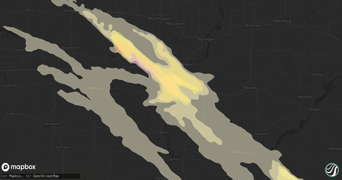
Hail Map in Keokuk, IA on September 18, 2022
Get this storm
September 18 map
$229
one time, instant access
Download today. No call, no setup
Keep the $229
Bought the map and want the full workflow? Apply the entire $229 to a subscription within 7 days. None of it is wasted.
Every map, not just this one
This buys you this map. Subscription and you get every map we run, in the markets you choose from a few cities to whole states to nationwide. Plus real-time alerts the moment a storm fires.
Contact data
Name, contact info, occupancy, even credit band for addresses in the footprint. You go from where it hit to who to call.
Become the source they trust
Unlimited branding weather history reports on demand. You already have the documented answer ready for the property owner, and you are the one who showed up with it.
Property data and RoofTrace estimates
Pull up any address you have got, its value and the exact code rules for that jurisdiction, straight from One Click Code. Then RoofTrace estimates the squares, pitch, and roof value, priced the way you price.
Storm reports in Keokuk, IA
Keokuk, IA
| Date | Description |
|---|---|
| 09/18/20221:25 AM CDT | A local report indicates 2.00 inch wind near 1 SSW MOOAR |
| 09/18/20221:25 AM CDT | A local report indicates 1.75 inch wind near 1 SSW MOOAR |
All States Impacted by Hail Map on September 18, 2022
All Cities Impacted by Hail Map on September 18, 2022
- Almont, MI
- Marseilles, IL
- Sheridan, IL
- Serena, IL
- Amboy, IL
- Morris, IL
- Princeton, IL
- Bloomfield, IA
- Floris, IA
- Plainwell, MI
- Fowlerville, MI
- Sheffield, IL
- Annawan, IL
- Mineral, IL
- Kalamazoo, MI
- Paw Paw, MI
- Portage, MI
- Mattawan, MI
- Carlock, IL
- Normal, IL
- Hudson, IL
- Danvers, IL
- Goodfield, IL
- Bloomington, IL
- Deer Creek, IL
- Kilbourne, IL
- Secor, IL
- El Paso, IL
- Douds, IA
- Keosauqua, IA
- Saint Anthony, ND
- Bangor, MI
- Bloomingdale, MI
- Gobles, MI
- South Haven, MI
- Grand Junction, MI
- Buda, IL
- Henry, IL
- Bradford, IL
- Putnam, IL
- Wyoming, IL
- Hampton, IL
- Blue Grass, IA
- Toulon, IL
- Stockton, IA
- Atkinson, IL
- Galva, IL
- Rock Island, IL
- Hillsdale, IL
- Tipton, IA
- Davenport, IA
- Princeton, IA
- Geneseo, IL
- Rapids City, IL
- West Branch, IA
- New Liberty, IA
- Cambridge, IL
- Carbon Cliff, IL
- Donahue, IA
- Moline, IL
- Colona, IL
- McCausland, IA
- Cordova, IL
- Albany, IL
- Osco, IL
- Andover, IL
- Dixon, IA
- Iowa City, IA
- Long Grove, IA
- West Liberty, IA
- Moscow, IA
- Camanche, IA
- Lynn Center, IL
- Bettendorf, IA
- Port Byron, IL
- Durant, IA
- Kewanee, IL
- Milan, IL
- Wilton, IA
- Atalissa, IA
- Eldridge, IA
- Bennett, IA
- Coal Valley, IL
- Neponset, IL
- Walcott, IA
- Silvis, IL
- Solon, IA
- Pleasant Valley, IA
- Le Claire, IA
- East Moline, IL
- Orion, IL
- Hampshire, IL
- Solen, ND
- Mandan, ND
- Warrenville, IL
- Naperville, IL
- West Chicago, IL
- Saint Charles, IL
- Maple Park, IL
- Winfield, IL
- Wheaton, IL
- North Aurora, IL
- Elburn, IL
- Glendale Heights, IL
- Aurora, IL
- Mooseheart, IL
- Hanover Park, IL
- Hinckley, IL
- Bloomingdale, IL
- Big Rock, IL
- Batavia, IL
- Carol Stream, IL
- Sugar Grove, IL
- Geneva, IL
- Illinois City, IL
- Taylor Ridge, IL
- Joy, IL
- Reynolds, IL
- Chenoa, IL
- Wheatland, IA
- Glen Ullin, ND
- Elgin, ND
- Mott, ND
- Carson, ND
- New Leipzig, ND
- Ely, IA
- Lisbon, IA
- Cedar Rapids, IA
- Mount Vernon, IA
- Mechanicsville, IA
- Oskaloosa, IA
- Eddyville, IA
- Kirkville, IA
- Cedar, IA
- Fremont, IA
- Washington, IL
- Moffit, ND
- Moravia, IA
- Moulton, IA
- Udell, IA
- Unionville, IA
- Centerville, IA
- Wayland, MO
- Kahoka, MO
- South Bend, IN
- New Carlisle, IN
- Wilmette, IL
- Kenilworth, IL
- Evanston, IL
- Munith, MI
- Stockbridge, MI
- Leslie, MI
- La Moille, IL
- Mendota, IL
- Ohio, IL
- Sublette, IL
- Van Orin, IL
- Elk Grove Village, IL
- Arlington Heights, IL
- Medinah, IL
- Itasca, IL
- Des Plaines, IL
- Mount Prospect, IL
- Dansville, MI
- Williamston, MI
- Webberville, MI
- Mason, MI
- Manlius, IL
- Wyanet, IL
- Walnut, IL
- Steward, IL
- Lee, IL
- Gridley, IL
- Hooppole, IL
- Prophetstown, IL
- Erie, IL
- Morrison, IL
- Sterling, IL
- Ottawa, IL
- Elmhurst, IL
- Berkeley, IL
- Oak Brook, IL
- Westchester, IL
- Hillside, IL
- Flasher, ND
- Park Ridge, IL
- Lincolnwood, IL
- Chicago, IL
- Skokie, IL
- Niles, IL
- Grass Lake, MI
- Pleasant Lake, MI
- Pinckney, MI
- Gregory, MI
- Three Rivers, MI
- Vicksburg, MI
- Amana, IA
- Swisher, IA
- North Liberty, IA
- Arenzville, IL
- Hickory Corners, MI
- Richland, MI
- Easton, IL
- Rushville, IL
- Memphis, MO
- Downing, MO
- Elmwood, IL
- Farmington, IL
- Yates City, IL
- Canton, IL
- Fairview, IL
- London Mills, IL
- Glasford, IL
- Norris, IL
- Trivoli, IL
- Ellisville, IL
- Avon, IL
- Pulaski, IA
- Milton, IA
- Farmersville, IL
- Heyworth, IL
- Wapella, IL
- Luray, MO
- Farmer City, IL
- Arrowsmith, IL
- Le Roy, IL
- Bonaparte, IA
- Donnellson, IA
- Farmington, IA
- Jacksonville, IL
- Concord, IL
- Franklin, IL
- Waverly, IL
- Camp Point, IL
- Clayton, IL
- Waggoner, IL
- Raymond, IL
- Queen City, MO
- Arbela, MO
- Montrose, IA
- Nauvoo, IL
- Keokuk, IA
- Argyle, IA
- Taylor, MO
- Palmyra, MO
- Virden, IL
- Girard, IL
- Harvel, IL
- Versailles, IL
- La Belle, MO
- Rutledge, MO
- Knox City, MO
- Lewistown, MO
- Gorin, MO
- Wyaconda, MO
- Bondville, IL
- Mahomet, IL
- Dewey, IL
- Champaign, IL
- Seymour, IL
- Mansfield, IL
- Auburn, IL
- Morrisonville, IL
- Downs, IL
- Sidney, IL
- Towanda, IL
- Congerville, IL
- Tolono, IL
- White Heath, IL
- Saybrook, IL
- Homer, IL
- Urbana, IL
- Ellsworth, IL
- Savoy, IL
- Broadlands, IL
- Cooksville, IL
- Foosland, IL
- Longview, IL
- Fisher, IL
- Bellflower, IL
- Philo, IL
- Saint Paul, IA
- West Point, IA
- Meredosia, IL
- Bluffs, IL
- Griggsville, IL
- Winchester, IL
- Ewing, MO
- Edina, MO
- Frederick, IL
- Mount Sterling, IL
- Littleton, IL
- Brocton, IL
- Hindsboro, IL
- Oakland, IL
- Mendon, IL
- Hamilton, IL
- Timewell, IL
- West Point, IL
- Eldon, IA
- Batavia, IA
- Carthage, IL
- Hillsboro, IA
- Dallas City, IL
- Elvaston, IL
- Salem, IA
- Loraine, IL
- Alexandria, MO
- Birmingham, IA
- Agency, IA
- Saint Patrick, MO
- Stockport, IA
- Niota, IL
- Fairfield, IA
- Libertyville, IA
- Ottumwa, IA
- Mount Sterling, IA
- Sutter, IL
- Fort Madison, IA
- Warsaw, IL
- Selma, IA
- Golden, IL
- La Harpe, IL
- Basco, IL
- Bowen, IL
- Sparland, IL
- East Peoria, IL
- Varna, IL
- Chapin, IL
- Modesto, IL
- Irving, IL
- Witt, IL
- Fillmore, IL
- Hillsboro, IL
- Camargo, IL
- Newman, IL
- Browning, IL
- Industry, IL
- Beardstown, IL
- Plymouth, IL
- Ortonville, MI
- Holly, MI
- Davisburg, MI
- Clarkston, MI
- Kansas, IL
- Tuscola, IL
- Villa Grove, IL
- Chesterfield, IL
- Huntsville, IL
- La Prairie, IL
- Camden, IL
- Hanna City, IL
- Mapleton, IL
- Rochester, IL
- Springfield, IL
- Riverton, IL
- Mechanicsburg, IL
- Sherman, IL
- Dawson, IL
- Durham, MO
- Maywood, MO
- Lexington, IL
- Astoria, IL
- Vermont, IL
- Elgin, IL
- Hoffman Estates, IL
- Muscatine, IA
- Glenwood, MO
- Unionville, MO
- Livonia, MO
- Colchester, IL
- Macomb, IL
- Lancaster, MO
- Hull, IL
- Hannibal, MO
- Baring, MO
- Monticello, MO
- Havana, IL
- Ipava, IL
- Bath, IL
- Lowpoint, IL
- Metamora, IL
- Rockbridge, IL
- Greenfield, IL
- Carlinville, IL
- Perry, IL
- Chambersburg, IL
- Regent, ND
- Ashmore, IL
- Arcola, IL
- Murdock, IL
- Roanoke, IL
- Paris, IL
- Peoria, IL
- Peoria Heights, IL
- Morton, IL
- Ivesdale, IL
- Pesotum, IL
- Charleston, IL
- Eureka, IL
- Creve Coeur, IL
- Sadorus, IL
- Monticello, IL
- Benson, IL
- Howell, MI
- Flanagan, IL
- Lockridge, IA
- Loda, IL
- Roberts, IL
- Sibley, IL
- Melvin, IL
- Murrayville, IL
- Augusta, IL
- Chandlerville, IL
- Virginia, IL
- Washburn, IL
- Lacon, IL
- La Rose, IL
- Minonk, IL
- Toluca, IL
- Buffalo, IL
- Athens, IL
- Petersburg, IL
- Elkhart, IL
- Williamsville, IL
- Middletown, IL
- Greenview, IL
- Cantrall, IL
- Edinburg, IL
- Oakford, IL
- Drakesville, IA
- Prairie City, IL
- Smithfield, IL
- Bushnell, IL
- Greentop, MO
- Baylis, IL
- Coatsburg, IL
- Williamstown, MO
- Ursa, IL
- La Grange, MO
- Fowler, IL
- Chillicothe, IA
- Paloma, IL
- Litchfield, IL
- Quincy, IL
- Liberty, IL
- Thayer, IL
- Butler, IL
- Melrose, IA
- Payson, IL
- Revere, MO
- Coatsville, MO
- New Salem, IL
- Alexander, IL
- Pittsfield, IL
- Barry, IL
- Plainville, IL
- Wayne, IL


