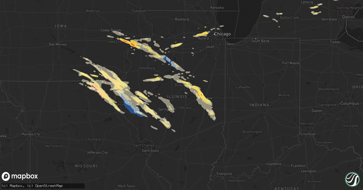
Hail Map in Illinois on September 18, 2022
Get this storm
September 18 map
$229
one time, instant access
Download today. No call, no setup
Keep the $229
Bought the map and want the full workflow? Apply the entire $229 to a subscription within 7 days. None of it is wasted.
Every map, not just this one
This buys you this map. Subscription and you get every map we run, in the markets you choose from a few cities to whole states to nationwide. Plus real-time alerts the moment a storm fires.
Contact data
Name, contact info, occupancy, even credit band for addresses in the footprint. You go from where it hit to who to call.
Become the source they trust
Unlimited branding weather history reports on demand. You already have the documented answer ready for the property owner, and you are the one who showed up with it.
Property data and RoofTrace estimates
Pull up any address you have got, its value and the exact code rules for that jurisdiction, straight from One Click Code. Then RoofTrace estimates the squares, pitch, and roof value, priced the way you price.
Storm reports in Illinois
Illinois
| Date | Description |
|---|---|
| 09/18/20226:41 AM CDT | At 1140 PM CDT, a severe thunderstorm was located over Hudson, or 7 miles north of Bloomington, moving east at 50 mph. HAZARD...60 mph wind gusts and half dollar size hail. SOURCE...Radar indicated. IMPACT...Hail damage to vehicles is expected. Expect wind damage to roofs, siding, and trees. This severe thunderstorm will be near... Towanda around 1145 PM CDT. Lexington around 1155 PM CDT. Cooksville around 1200 AM CDT.Other locations in the path of this severe thunderstorm includeColfax and Saybrook.This includes the following highways... Interstate 39 between mile markers 0 and 7. Interstate 55 between mile markers 160 and 187. Interstate 74 between mile markers 121 and 130. |
| 09/18/20226:33 AM CDT | At 1132 PM CDT, a severe thunderstorm was located near Pontiac, moving east at 50 mph. HAZARD...60 mph wind gusts and quarter size hail. SOURCE...Radar indicated. IMPACT...Hail damage to vehicles is expected. Expect wind damage to roofs, siding, and trees. Locations impacted include... Pontiac, Fairbury, Chatsworth, Gridley, Forrest, Flanagan, Odell, Cullom, Saunemin, Campus, Emington and Strawn.Including the following interstate... I-55 between mile markers 188 and 209. |
| 09/18/20226:27 AM CDT | At 1127 PM CDT, a severe thunderstorm was located over Winchester, moving southeast at 55 mph. HAZARD...60 mph wind gusts and half dollar size hail. SOURCE...Radar indicated. IMPACT...Hail damage to vehicles is expected. Expect wind damage to roofs, siding, and trees. This severe thunderstorm will be near... Manchester around 1135 PM CDT. Murrayville and Woodson around 1140 PM CDT.This includes Interstate 72 between mile markers 44 and 70. |
| 09/18/20226:26 AM CDT | At 1126 PM CDT, a severe thunderstorm was located near Secor, or 11 miles northeast of Eureka, moving southeast at 40 mph. HAZARD...60 mph wind gusts and quarter size hail. SOURCE...Radar indicated. IMPACT...Hail damage to vehicles is expected. Expect wind damage to roofs, siding, and trees. This severe thunderstorm will be near... El Paso around 1135 PM CDT. Gridley around 1145 PM CDT.Other locations in the path of this severe thunderstorm includeLexington and Chenoa.This includes the following highways... Interstate 39 between mile markers 3 and 28. Interstate 55 between mile markers 167 and 186. |
| 09/18/20226:04 AM CDT | At 1102 PM CDT, a severe thunderstorm was located near Washburn, or 10 miles southeast of Lacon, moving southeast at 45 mph. HAZARD...60 mph wind gusts and quarter size hail. SOURCE...Radar indicated. IMPACT...Hail damage to vehicles is expected. Expect wind damage to roofs, siding, and trees. Locations impacted include... Gridley and Flanagan. Including the following interstate... I-55 between mile markers 188 and 191. |
| 09/18/20226:00 AM CDT | At 1100 PM CDT, a severe thunderstorm was located near Meredosia, or 15 miles southwest of Beardstown, moving southeast at 60 mph. HAZARD...60 mph wind gusts and quarter size hail. SOURCE...Radar indicated. IMPACT...Hail damage to vehicles is expected. Expect wind damage to roofs, siding, and trees. This severe thunderstorm will be near... Bluffs around 1105 PM CDT. Exeter around 1110 PM CDT. Winchester and Chapin around 1115 PM CDT. Jacksonville around 1120 PM CDT. Murrayville and Woodson around 1125 PM CDT. Franklin around 1130 PM CDT.Other locations impacted by this severe thunderstorm includeNortonville, Riggston, Merritt, Lynnville, South Jacksonville,Jacksonville Municipal Airport, La Grange, Concord, Glasgow andOxville.This includes Interstate 72 between mile markers 43 and 73. |
| 09/18/20225:58 AM CDT | At 1058 PM CDT, a severe thunderstorm was located over Washington, or 7 miles west of Eureka, moving east at 60 mph. HAZARD...60 mph wind gusts and quarter size hail. SOURCE...Radar indicated. IMPACT...Hail damage to vehicles is expected. Expect wind damage to roofs, siding, and trees. This severe thunderstorm will be near... Eureka and Goodfield around 1105 PM CDT. Roanoke and Secor around 1110 PM CDT. El Paso around 1120 PM CDT. Gridley around 1125 PM CDT.Other locations impacted by this severe thunderstorm includeCongerville, Evergreen Lake, Kappa, Peoria Heights, Panola, Grovelandand Lake Bloomington.This includes the following highways... Interstate 39 between mile markers 6 and 22. Interstate 474 between mile markers 12 and 14. Interstate 74 between mile markers 96 and 117. |
| 09/18/20225:55 AM CDT | At 1054 PM CDT, a severe thunderstorm was located near Maywood, moving southeast at 35 mph. HAZARD...60 mph wind gusts and quarter size hail. SOURCE...Radar indicated. IMPACT...Hail damage to vehicles is expected. Expect wind damage to roofs, siding, and trees. This severe thunderstorm will be near... Palmyra around 1105 PM CDT.Other locations in the path of this severe thunderstorm includeHannibal, Payson and Fall Creek.This includes the following highways... Interstate 172 between exits 2 and 10. Interstate 72 near exit 4. |
| 09/18/20225:46 AM CDT | At 1046 PM CDT, severe thunderstorms were located along a line extending from near Varna to Lacon to near Wyoming, moving southeast at 40 mph. HAZARD...70 mph wind gusts and quarter size hail. SOURCE...Radar indicated. IMPACT...Hail damage to vehicles is expected. Expect considerable tree damage. Wind damage is also likely to mobile homes, roofs, and outbuildings. Severe thunderstorms will be near... Lacon, Henry and Varna around 1050 PM CDT. Toluca and Washburn around 1100 PM CDT. Chillicothe and Wenona around 1105 PM CDT.Other locations in the path of these severe thunderstorms includeRome, Minonk, Metamora and Roanoke.This includes Interstate 39 between mile markers 22 and 40. |
| 09/18/20225:43 AM CDT | At 1042 PM CDT, a severe thunderstorm was located over Geneva, moving east at 50 mph. HAZARD...Quarter size hail. SOURCE...Radar indicated. IMPACT...Damage to vehicles is expected. Locations impacted include... Chicago, Aurora, Schaumburg, Des Plaines, Berwyn, Mount Prospect, Wheaton, Oak Park, Downers Grove, Elmhurst, Lombard, Bartlett, Ohare Airport, Streamwood, Carol Stream, Hanover Park, Park Ridge, Addison, Glendale Heights and Elk Grove Village.Including the following interstates... I-88 near mile marker 110, and between mile markers 133 and 140. I-90 between mile markers 73 and 82. I-290 between mile markers 3 and 22. I-355 between mile markers 22 and 30.This includes... Brookfield Zoo, Schaumburg Boomers Baseball, TritonCollege, College of DuPage, DuPage County Fairgrounds, Fermilab, KaneCounty Cougars Ballpark, Morton Arboretum, and Wheaton College. |
| 09/18/20225:32 AM CDT | At 1031 PM CDT, severe thunderstorms were located along a line extending from near Clayton to 8 miles north of Beverly to near Quincy Regional Airport, moving southeast at 35 mph. HAZARD...70 mph wind gusts. SOURCE...Emergency management reported power lines down in Camp Point. IMPACT...Expect considerable tree damage. Damage is likely to mobile homes, roofs, and outbuildings. Severe thunderstorms will be near... Mount Sterling and Buckhorn around 1045 PM CDT. Beverly around 1050 PM CDT.Other locations in the path of these severe thunderstorms includeBarry, Griggsville and Pittsfield.This includes Interstate 72 between exits 20 and 35. This also includes Siloam Springs State Park. |
| 09/18/20225:30 AM CDT | At 1029 PM CDT, a severe thunderstorm was located near Trivoli, or 8 miles northeast of Canton, moving east at 55 mph. HAZARD...60 mph wind gusts and quarter size hail. SOURCE...Radar indicated. IMPACT...Hail damage to vehicles is expected. Expect wind damage to roofs, siding, and trees. This severe thunderstorm will be near... Hanna City around 1035 PM CDT. Peoria, Pekin, Bartonville, West Peoria and Bellevue around 1045 PM CDT. Creve Coeur and Marquette Heights around 1050 PM CDT. East Peoria and Morton around 1055 PM CDT. Washington around 1100 PM CDT.Other locations impacted by this severe thunderstorm include Norwood,North Pekin, Smithville, Peoria International Airport, Mapleton,Groveland, Kingston Mines and Peoria Heights.This includes the following highways... Interstate 155 between mile markers 27 and 31. Interstate 474 between mile markers 2 and 14. Interstate 74 between mile markers 90 and 103. |
| 09/18/20225:14 AM CDT | At 1013 PM CDT, a severe thunderstorm was located near Kewanee, moving southeast at 30 mph. HAZARD...60 mph wind gusts and half dollar size hail. SOURCE...Radar indicated. IMPACT...Hail damage to vehicles is expected. Expect wind damage to roofs, siding, and trees. This severe thunderstorm will be near... Osceola and Elmira around 1035 PM CDT. Bradford and Castleton around 1050 PM CDT. Camp Grove around 1100 PM CDT. |
| 09/18/20225:11 AM CDT | At 1011 PM CDT, severe thunderstorms were located along a line extending from Manlius to near La Fayette, moving southeast at 50 mph. HAZARD...60 mph wind gusts and quarter size hail. SOURCE...Radar indicated. IMPACT...Hail damage to vehicles is expected. Expect wind damage to roofs, siding, and trees. Locations impacted include... Kewanee, Galva, Wyanet, Sheffield, Annawan, Tiskilwa, Buda, Neponset, Manlius, Mineral, Milo, Bishop Hill, New Bedford, Thomas, Providence, German Corner, Kewanee Municipal Airport, Johnson-Sauk Trail State Park and Lone Tree Corners. |
| 09/18/20225:01 AM CDT | At 1001 PM CDT, a severe thunderstorm was located near Ewing, moving southeast at 35 mph. HAZARD...60 mph wind gusts and half dollar size hail. SOURCE...Public reported half dollar sized hail in La Belle. IMPACT...Hail damage to vehicles is expected. Expect wind damage to roofs, siding, and trees. This severe thunderstorm will be near... Ewing around 1005 PM CDT. Maywood around 1020 PM CDT.Other locations in the path of this severe thunderstorm includePalmyra.This includes Interstate 172 between exits 10 and 14. This also includes Wakonda State Park. |
| 09/18/20224:47 AM CDT | At 947 PM CDT, a severe thunderstorm was located near Osco, or near Cambridge, moving southeast at 25 mph. HAZARD...60 mph wind gusts and half dollar size hail. SOURCE...Radar indicated. IMPACT...Hail damage to vehicles is expected. Expect wind damage to roofs, siding, and trees. Locations impacted include... Kewanee, Cambridge, Geneseo, Atkinson, Annawan, Osco, Henry County Fairgrounds, German Corner, Morristown and Johnson-Sauk Trail State Park. |
| 09/18/20224:35 AM CDT | At 934 PM CDT, a severe thunderstorm was located near La Moille, or 8 miles south of Amboy, moving northeast at 35 mph. HAZARD...Half dollar size hail. SOURCE...Radar indicated. IMPACT...Damage to vehicles is expected. Locations impacted include... Mendota, Shabbona, Earlville, Malta, Paw Paw, Sublette, Woodhaven Lakes, Lee, Compton, Steward, West Brooklyn, Triumph and Harding.Including the following interstates... I-39 between mile markers 67 and 95. I-88 between mile markers 83 and 88.This includes... Tri-County Fairgrounds. |
| 09/18/20223:24 AM CDT | At 824 PM CDT, a severe thunderstorm was located over Kewanee, moving east at 55 mph. HAZARD...60 mph wind gusts and quarter size hail. SOURCE...Radar indicated. IMPACT...Hail damage to vehicles is expected. Expect wind damage to roofs, siding, and trees. This severe thunderstorm will be near... Osceola around 830 PM CDT. Castleton around 835 PM CDT. Bradford around 840 PM CDT. |
| 09/18/20223:18 AM CDT | At 817 PM CDT, a severe thunderstorm was located over German Corner, or near Kewanee, moving east at 40 mph. HAZARD...60 mph wind gusts and quarter size hail. SOURCE...Radar indicated. IMPACT...Hail damage to vehicles is expected. Expect wind damage to roofs, siding, and trees. This severe thunderstorm will be near... Johnson-Sauk Trail State Park around 825 PM CDT. Sheffield and Neponset around 835 PM CDT.Other locations in the path of this severe thunderstorm include Buda,Milo, Providence, Tiskilwa and Lone Tree Corners. |
| 09/18/20221:30 AM CDT | Multiple large trees down around jacksonville... Over a foot in diameter. |
| 09/18/20221:30 AM CDT | Numerous pine trees snapped or broken. Time estimated by radar. Relayed by broadcast media. |
| 09/18/20221:25 AM CDT | 6 inch diameter tree limbs broken. Time estimated from radar. Relayed by wcia-tv. |
| 09/18/20221:24 AM CDT | A local report indicates 1.00 inch wind near JACKSONVILLE |
| 09/18/20221:22 AM CDT | Dime size hail started at 117 am and last 5 minutes near mckinley and park ave. Half dollar size hail at 122 am. |
| 09/18/20221:20 AM CDT | A local report indicates 1.00 inch wind near 1 ENE CHAMPAIGN |
| 09/18/20221:06 AM CDT | A local report indicates 2.50 inch wind near MAHOMET |
| 09/18/20221:05 AM CDT | Tree down on il 47 north of mahomet... Blocking roadway. |
| 09/18/20221:03 AM CDT | A local report indicates 1.75 inch wind near 2 NW MAHOMET |
| 09/18/20221:00 AM CDT | A local report indicates 1.00 inch wind near 1 WNW MAHOMET |
| 09/18/202212:51 AM CDT | A local report indicates 60 MPH wind near 1 E NORMAL |
| 09/18/202212:49 AM CDT | Damage to outbuildings and trees greater than 3 feet in diameter snapped at the base in osman. |
| 09/18/202212:45 AM CDT | Multiple trees and tree branches down. |
| 09/18/202212:41 AM CDT | Multiple trees down with 2 broken windows. |
| 09/18/202212:30 AM CDT | Semi blown over... Tree limbs down on power lines. |
| 09/18/202212:30 AM CDT | Power pole fell into a mobile home. |
| 09/18/202212:15 AM CDT | A local report indicates 1.00 inch wind near 2 N NORMAL |
| 09/18/202212:05 AM CDT | Awos station kbmi bloomington arpt. |
| 09/18/202212:04 AM CDT | 4 to 5 in diameter tree limbs down. |
| 09/17/202211:55 PM CDT | A local report indicates 60 MPH wind near 3 ENE NORMAL |
| 09/17/202211:54 PM CDT | Large pine tree downed. |
| 09/17/202211:40 PM CDT | A local report indicates 1.00 inch wind near CAZENOVIA |
| 09/17/202211:38 PM CDT | Corrects previous hail report from nauvoo. |
| 09/17/202211:23 PM CDT | Report of wires down at the intersection of 400 road east and 1000 road north in flanagan. Time estimated from radar. |
| 09/17/202211:12 PM CDT | Tree snapped north of washburn on hwy 89. |
| 09/17/202210:53 PM CDT | Measured near intersection of kirk road and main street. |
| 09/17/202210:53 PM CDT | Report from mping: half dollar |
| 09/17/202210:52 PM CDT | Numerous trees down on roads near peoria stadium. |
| 09/17/202210:52 PM CDT | A local report indicates 60 MPH wind near 3 W WASHINGTON |
| 09/17/202210:50 PM CDT | A local report indicates 1.50 inch wind near 2 WNW DUPAGE AIRPORT |
| 09/17/202210:50 PM CDT | Multiple tree limbs down near holy family church. |
| 09/17/202210:49 PM CDT | Trees down across war memorial drive... Near city stadium. |
| 09/17/202210:46 PM CDT | Multiple reports received via social media of 1 to 1.5 inch diameter hail in geneva between 1046 and 1050 pm. |
| 09/17/202210:32 PM CDT | Grain bin fell on top of another lp tank. |
| 09/17/202210:31 PM CDT | Grain bin down... Utility poles snapped... And an overturned lp tank near location. |
| 09/17/202210:30 PM CDT | Power lines down. |
| 09/17/202210:25 PM CDT | A local report indicates 1.00 inch wind near FARMINGTON |
| 09/17/202210:25 PM CDT | Large pine tree uprooted. |
| 09/17/202210:25 PM CDT | Corrects previous tstm wnd dmg report from golden. Numerous branches down... Corn flattened... And widespread power outages. One tree fell onto a house. |
| 09/17/202210:17 PM CDT | Twisted tree tops just south of us route 24. Time estimated from radar. |
| 09/17/202210:00 PM CDT | Small tree limbs down. |
| 09/17/202210:00 PM CDT | Many trees down. Estimated 70 to 80 mph winds. |
| 09/17/20229:55 PM CDT | 16 inch tree limb snapped. |
| 09/17/20229:50 PM CDT | Tree limbs down. |
| 09/17/20229:47 PM CDT | Tree blown down. |
| 09/17/20228:45 PM CDT | A local report indicates 1.00 inch wind near KEWANEE |
All States Impacted by Hail Map on September 18, 2022
Cities Impacted by Hail Map on September 18, 2022
- Almont, MI
- Marseilles, IL
- Sheridan, IL
- Serena, IL
- Amboy, IL
- Morris, IL
- Princeton, IL
- Bloomfield, IA
- Floris, IA
- Plainwell, MI
- Fowlerville, MI
- Sheffield, IL
- Annawan, IL
- Mineral, IL
- Kalamazoo, MI
- Paw Paw, MI
- Portage, MI
- Mattawan, MI
- Carlock, IL
- Normal, IL
- Hudson, IL
- Danvers, IL
- Goodfield, IL
- Bloomington, IL
- Deer Creek, IL
- Kilbourne, IL
- Secor, IL
- El Paso, IL
- Douds, IA
- Keosauqua, IA
- Saint Anthony, ND
- Bangor, MI
- Bloomingdale, MI
- Gobles, MI
- South Haven, MI
- Grand Junction, MI
- Buda, IL
- Henry, IL
- Bradford, IL
- Putnam, IL
- Wyoming, IL
- Hampton, IL
- Blue Grass, IA
- Toulon, IL
- Stockton, IA
- Atkinson, IL
- Galva, IL
- Rock Island, IL
- Hillsdale, IL
- Tipton, IA
- Davenport, IA
- Princeton, IA
- Geneseo, IL
- Rapids City, IL
- West Branch, IA
- New Liberty, IA
- Cambridge, IL
- Carbon Cliff, IL
- Donahue, IA
- Moline, IL
- Colona, IL
- McCausland, IA
- Cordova, IL
- Albany, IL
- Osco, IL
- Andover, IL
- Dixon, IA
- Iowa City, IA
- Long Grove, IA
- West Liberty, IA
- Moscow, IA
- Camanche, IA
- Lynn Center, IL
- Bettendorf, IA
- Port Byron, IL
- Durant, IA
- Kewanee, IL
- Milan, IL
- Wilton, IA
- Atalissa, IA
- Eldridge, IA
- Bennett, IA
- Coal Valley, IL
- Neponset, IL
- Walcott, IA
- Silvis, IL
- Solon, IA
- Pleasant Valley, IA
- Le Claire, IA
- East Moline, IL
- Orion, IL
- Hampshire, IL
- Solen, ND
- Mandan, ND
- Warrenville, IL
- Naperville, IL
- West Chicago, IL
- Saint Charles, IL
- Maple Park, IL
- Winfield, IL
- Wheaton, IL
- North Aurora, IL
- Elburn, IL
- Glendale Heights, IL
- Aurora, IL
- Mooseheart, IL
- Hanover Park, IL
- Hinckley, IL
- Bloomingdale, IL
- Big Rock, IL
- Batavia, IL
- Carol Stream, IL
- Sugar Grove, IL
- Geneva, IL
- Illinois City, IL
- Taylor Ridge, IL
- Joy, IL
- Reynolds, IL
- Chenoa, IL
- Wheatland, IA
- Glen Ullin, ND
- Elgin, ND
- Mott, ND
- Carson, ND
- New Leipzig, ND
- Ely, IA
- Lisbon, IA
- Cedar Rapids, IA
- Mount Vernon, IA
- Mechanicsville, IA
- Oskaloosa, IA
- Eddyville, IA
- Kirkville, IA
- Cedar, IA
- Fremont, IA
- Washington, IL
- Moffit, ND
- Moravia, IA
- Moulton, IA
- Udell, IA
- Unionville, IA
- Centerville, IA
- Wayland, MO
- Kahoka, MO
- South Bend, IN
- New Carlisle, IN
- Wilmette, IL
- Kenilworth, IL
- Evanston, IL
- Munith, MI
- Stockbridge, MI
- Leslie, MI
- La Moille, IL
- Mendota, IL
- Ohio, IL
- Sublette, IL
- Van Orin, IL
- Elk Grove Village, IL
- Arlington Heights, IL
- Medinah, IL
- Itasca, IL
- Des Plaines, IL
- Mount Prospect, IL
- Dansville, MI
- Williamston, MI
- Webberville, MI
- Mason, MI
- Manlius, IL
- Wyanet, IL
- Walnut, IL
- Steward, IL
- Lee, IL
- Gridley, IL
- Hooppole, IL
- Prophetstown, IL
- Erie, IL
- Morrison, IL
- Sterling, IL
- Ottawa, IL
- Elmhurst, IL
- Berkeley, IL
- Oak Brook, IL
- Westchester, IL
- Hillside, IL
- Flasher, ND
- Park Ridge, IL
- Lincolnwood, IL
- Chicago, IL
- Skokie, IL
- Niles, IL
- Grass Lake, MI
- Pleasant Lake, MI
- Pinckney, MI
- Gregory, MI
- Three Rivers, MI
- Vicksburg, MI
- Amana, IA
- Swisher, IA
- North Liberty, IA
- Arenzville, IL
- Hickory Corners, MI
- Richland, MI
- Easton, IL
- Rushville, IL
- Memphis, MO
- Downing, MO
- Elmwood, IL
- Farmington, IL
- Yates City, IL
- Canton, IL
- Fairview, IL
- London Mills, IL
- Glasford, IL
- Norris, IL
- Trivoli, IL
- Ellisville, IL
- Avon, IL
- Pulaski, IA
- Milton, IA
- Farmersville, IL
- Heyworth, IL
- Wapella, IL
- Luray, MO
- Farmer City, IL
- Arrowsmith, IL
- Le Roy, IL
- Bonaparte, IA
- Donnellson, IA
- Farmington, IA
- Jacksonville, IL
- Concord, IL
- Franklin, IL
- Waverly, IL
- Camp Point, IL
- Clayton, IL
- Waggoner, IL
- Raymond, IL
- Queen City, MO
- Arbela, MO
- Montrose, IA
- Nauvoo, IL
- Keokuk, IA
- Argyle, IA
- Taylor, MO
- Palmyra, MO
- Virden, IL
- Girard, IL
- Harvel, IL
- Versailles, IL
- La Belle, MO
- Rutledge, MO
- Knox City, MO
- Lewistown, MO
- Gorin, MO
- Wyaconda, MO
- Bondville, IL
- Mahomet, IL
- Dewey, IL
- Champaign, IL
- Seymour, IL
- Mansfield, IL
- Auburn, IL
- Morrisonville, IL
- Downs, IL
- Sidney, IL
- Towanda, IL
- Congerville, IL
- Tolono, IL
- White Heath, IL
- Saybrook, IL
- Homer, IL
- Urbana, IL
- Ellsworth, IL
- Savoy, IL
- Broadlands, IL
- Cooksville, IL
- Foosland, IL
- Longview, IL
- Fisher, IL
- Bellflower, IL
- Philo, IL
- Saint Paul, IA
- West Point, IA
- Meredosia, IL
- Bluffs, IL
- Griggsville, IL
- Winchester, IL
- Ewing, MO
- Edina, MO
- Frederick, IL
- Mount Sterling, IL
- Littleton, IL
- Brocton, IL
- Hindsboro, IL
- Oakland, IL
- Mendon, IL
- Hamilton, IL
- Timewell, IL
- West Point, IL
- Eldon, IA
- Batavia, IA
- Carthage, IL
- Hillsboro, IA
- Dallas City, IL
- Elvaston, IL
- Salem, IA
- Loraine, IL
- Alexandria, MO
- Birmingham, IA
- Agency, IA
- Saint Patrick, MO
- Stockport, IA
- Niota, IL
- Fairfield, IA
- Libertyville, IA
- Ottumwa, IA
- Mount Sterling, IA
- Sutter, IL
- Fort Madison, IA
- Warsaw, IL
- Selma, IA
- Golden, IL
- La Harpe, IL
- Basco, IL
- Bowen, IL
- Sparland, IL
- East Peoria, IL
- Varna, IL
- Chapin, IL
- Modesto, IL
- Irving, IL
- Witt, IL
- Fillmore, IL
- Hillsboro, IL
- Camargo, IL
- Newman, IL
- Browning, IL
- Industry, IL
- Beardstown, IL
- Plymouth, IL
- Ortonville, MI
- Holly, MI
- Davisburg, MI
- Clarkston, MI
- Kansas, IL
- Tuscola, IL
- Villa Grove, IL
- Chesterfield, IL
- Huntsville, IL
- La Prairie, IL
- Camden, IL
- Hanna City, IL
- Mapleton, IL
- Rochester, IL
- Springfield, IL
- Riverton, IL
- Mechanicsburg, IL
- Sherman, IL
- Dawson, IL
- Durham, MO
- Maywood, MO
- Lexington, IL
- Astoria, IL
- Vermont, IL
- Elgin, IL
- Hoffman Estates, IL
- Muscatine, IA
- Glenwood, MO
- Unionville, MO
- Livonia, MO
- Colchester, IL
- Macomb, IL
- Lancaster, MO
- Hull, IL
- Hannibal, MO
- Baring, MO
- Monticello, MO
- Havana, IL
- Ipava, IL
- Bath, IL
- Lowpoint, IL
- Metamora, IL
- Rockbridge, IL
- Greenfield, IL
- Carlinville, IL
- Perry, IL
- Chambersburg, IL
- Regent, ND
- Ashmore, IL
- Arcola, IL
- Murdock, IL
- Roanoke, IL
- Paris, IL
- Peoria, IL
- Peoria Heights, IL
- Morton, IL
- Ivesdale, IL
- Pesotum, IL
- Charleston, IL
- Eureka, IL
- Creve Coeur, IL
- Sadorus, IL
- Monticello, IL
- Benson, IL
- Howell, MI
- Flanagan, IL
- Lockridge, IA
- Loda, IL
- Roberts, IL
- Sibley, IL
- Melvin, IL
- Murrayville, IL
- Augusta, IL
- Chandlerville, IL
- Virginia, IL
- Washburn, IL
- Lacon, IL
- La Rose, IL
- Minonk, IL
- Toluca, IL
- Buffalo, IL
- Athens, IL
- Petersburg, IL
- Elkhart, IL
- Williamsville, IL
- Middletown, IL
- Greenview, IL
- Cantrall, IL
- Edinburg, IL
- Oakford, IL
- Drakesville, IA
- Prairie City, IL
- Smithfield, IL
- Bushnell, IL
- Greentop, MO
- Baylis, IL
- Coatsburg, IL
- Williamstown, MO
- Ursa, IL
- La Grange, MO
- Fowler, IL
- Chillicothe, IA
- Paloma, IL
- Litchfield, IL
- Quincy, IL
- Liberty, IL
- Thayer, IL
- Butler, IL
- Melrose, IA
- Payson, IL
- Revere, MO
- Coatsville, MO
- New Salem, IL
- Alexander, IL
- Pittsfield, IL
- Barry, IL
- Plainville, IL
- Wayne, IL


