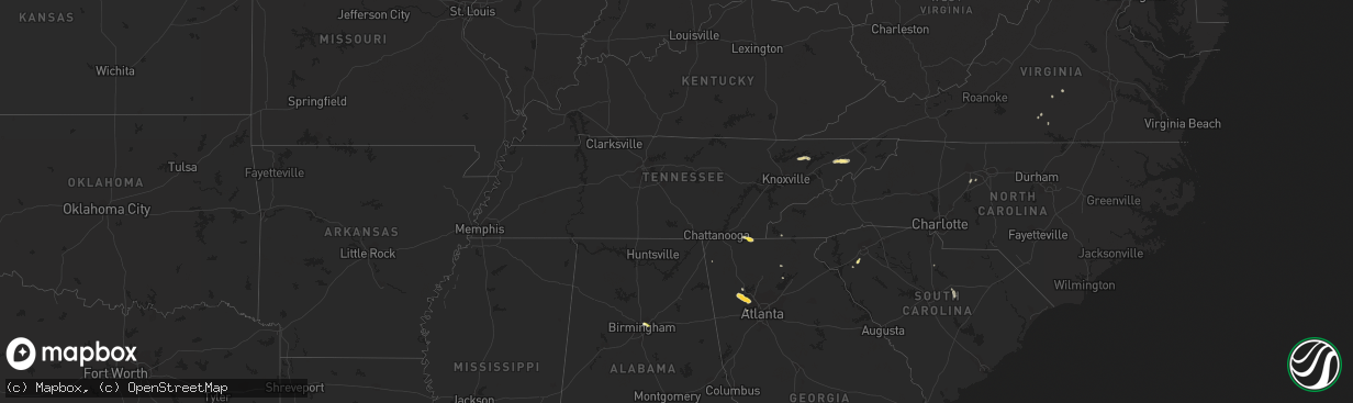
Hail Map in Tennessee on September 12, 2023
The weather event in Tennessee on September 12, 2023 includes Hail and Wind maps. 12 states and 97 cities were impacted and suffered possible damage. The total estimated number of properties impacted is 284.
Want more than just the map?
Turn this storm into a full workflow.
- Owner + property data so you know who to knock
- OnDemand branded weather history reports to win the "did we even have hail?" argument
- RoofTrace estimate so reps stop guessing numbers at the door
Bought this map? Upgrade within 7 days and we'll credit the $230. (10-15 min setup call)
Hail
Wind
284
Estimated number of impacted properties by a 1.00" hail or larger0
Estimated number of impacted properties by a 1.75" hail or larger0
Estimated number of impacted properties by a 2.50" hail or largerStorm reports in Tennessee
Tennessee
| Date | Description |
|---|---|
| 09/12/20234:45 PM CDT | A few trees down. |
| 09/12/20233:54 PM CDT | Trees down at newt road and washington college station road in the limestone area. Time estimated from radar. |
| 09/12/20233:50 PM CDT | Trees down at intersection of old state route 34 and taylor mill road near limestone. Time estimated from radar. |
| 09/12/20233:40 PM CDT | Trees down north and northeast of greeneville. Time estimated from radar. |
| 09/12/20233:30 PM CDT | Several trees down. |
| 09/12/20232:51 PM CDT | Several trees down. |
| 09/12/20232:08 PM CDT | Large limb down. |
All States Impacted by Hail Map on September 12, 2023
Cities Impacted by Hail Map on September 12, 2023
- Alum Creek, WV
- Gainesville, GA
- Dahlonega, GA
- Belton, SC
- Williamston, SC
- Pelzer, SC
- Afton, TN
- Greeneville, TN
- Dallas, GA
- Acworth, GA
- Kennesaw, GA
- Powder Springs, GA
- Marietta, GA
- Chandler, AZ
- Cisco, GA
- Bisbee, AZ
- Saint Cloud, FL
- Chuckey, TN
- Dawsonville, GA
- Farmville, VA
- Brookneal, VA
- Nathalie, VA
- Rutledge, TN
- Mosheim, TN
- Crandall, GA
- Old Fort, TN
- Washburn, TN
- Douglasville, GA
- Lithia Springs, GA
- Elgin, AZ
- Vail, AZ
- Jesup, GA
- Screven, GA
- Odum, GA
- Limestone, TN
- Sonoita, AZ
- Cartersville, GA
- Emerson, GA
- Nahunta, GA
- Apalachicola, FL
- Brasstown, NC
- Jasper, FL
- Thomasville, NC
- Birmingham, AL
- Mesa, AZ
- Apache Junction, AZ
- Middle River, MD
- Essex, MD
- Aragon, NM
- Reserve, NM
- Jacksonville, FL
- Webster, FL
- Great Falls, SC
- Winston Salem, NC
- Lexington, NC
- Hilliard, FL
- Red Oak, VA
- Randolph, VA
- Saxe, VA
- Truth Or Consequences, NM
- Rembert, SC
- Kensington, MD
- Silver Spring, MD
- Chevy Chase, MD
- Bethesda, MD
- Bryceville, FL
- Palatka, FL
- Patterson, GA
- Folkston, GA
- Hoboken, GA
- Pamplin, VA
- Prospect, VA
- Scottsdale, AZ
- White Oak, GA
- La Fayette, GA
- Buckeye, AZ
- Blackshear, GA
- Interlachen, FL
- Easton, MD
- Black Canyon City, AZ
- Florence, AZ
- Phoenix, AZ
- Cordova, MD
- Prescott, AZ
- Casa Grande, AZ
- Mayer, AZ
- Coolidge, AZ
- Tempe, AZ
- Cave Creek, AZ
- Dalzell, SC
- Peoria, AZ
- Litchfield Park, AZ
- Congress, AZ
- Cabin John, MD
- Globe, AZ
- Peridot, AZ
- Glen Echo, MD


