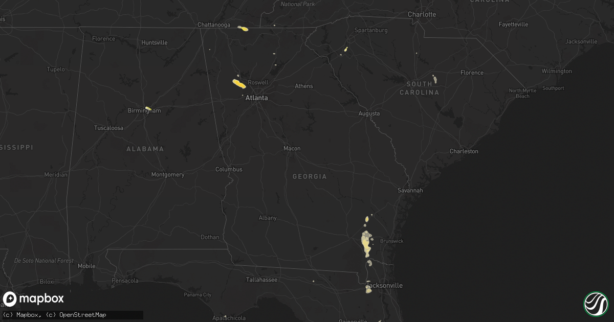
Hail Map in Georgia on September 12, 2023
Get this storm
September 12 map
$229
one time, instant access
Download today. No call, no setup
Keep the $229
Bought the map and want the full workflow? Apply the entire $229 to a subscription within 7 days. None of it is wasted.
Every map, not just this one
This buys you this map. Subscription and you get every map we run, in the markets you choose from a few cities to whole states to nationwide. Plus real-time alerts the moment a storm fires.
Contact data
Name, contact info, occupancy, even credit band for addresses in the footprint. You go from where it hit to who to call.
Become the source they trust
Unlimited branding weather history reports on demand. You already have the documented answer ready for the property owner, and you are the one who showed up with it.
Property data and RoofTrace estimates
Pull up any address you have got, its value and the exact code rules for that jurisdiction, straight from One Click Code. Then RoofTrace estimates the squares, pitch, and roof value, priced the way you price.
Storm reports in Georgia
Georgia
| Date | Description |
|---|---|
| 09/12/20236:50 PM CDT | Thunderstorm winds caused damage to a home off highway 301... Including multiple electric wires down. Time estimated by radar. |
| 09/12/20236:35 PM CDT | Tree down on knox rd caused by thunderstorm winds. Time estimated by radar. |
| 09/12/20235:28 PM CDT | A couple trees across powerlines in screven... Pea size hail reported on highway 84 and highway 203. Lightning struck house on spring grove road. |
| 09/12/20235:28 PM CDT | A couple trees across powerlines in screven... Pea size hail reported on highway 84 and highway 203. Lightning struck house on sp |
| 09/12/20234:25 PM CDT | Golf ball-size hail reported at intersection of mars hill rd and hadaway rd. |
| 09/12/20234:20 PM CDT | Half dollar-size hail reported at intersection of brookstone dr nw and mclain rd. |
| 09/12/20234:17 PM CDT | Report of quarter sized hail near mars hill rd and old stilesboro rd nw. |
| 09/12/20234:17 PM CDT | Golf ball sized hail reported at brookestone country club near brookstone dr nw and burnt hickory rd nw. |
| 09/12/20234:16 PM CDT | Report of quarter inch hail off of mary wallace way and royal sunset dr. |
| 09/12/20234:10 PM CDT | Quarter-size hail reported at intersection of cedarcrest rd and dallas acworth hwy. |
| 09/12/20234:00 PM CDT | Trees and power lines down in intersection of due west rd and hwy 92. |
| 09/12/20234:00 PM CDT | Power lines and trees down in roadway of brooks rackley rd and wildwood way. |
| 09/12/20233:55 PM CDT | Tree down at narroway church cir and abigail way. |
All States Impacted by Hail Map on September 12, 2023
Cities Impacted by Hail Map on September 12, 2023
- Alum Creek, WV
- Gainesville, GA
- Dahlonega, GA
- Belton, SC
- Williamston, SC
- Pelzer, SC
- Afton, TN
- Greeneville, TN
- Dallas, GA
- Acworth, GA
- Kennesaw, GA
- Powder Springs, GA
- Marietta, GA
- Chandler, AZ
- Cisco, GA
- Bisbee, AZ
- Saint Cloud, FL
- Chuckey, TN
- Dawsonville, GA
- Farmville, VA
- Brookneal, VA
- Nathalie, VA
- Rutledge, TN
- Mosheim, TN
- Crandall, GA
- Old Fort, TN
- Washburn, TN
- Douglasville, GA
- Lithia Springs, GA
- Elgin, AZ
- Vail, AZ
- Jesup, GA
- Screven, GA
- Odum, GA
- Limestone, TN
- Sonoita, AZ
- Cartersville, GA
- Emerson, GA
- Nahunta, GA
- Apalachicola, FL
- Brasstown, NC
- Jasper, FL
- Thomasville, NC
- Birmingham, AL
- Mesa, AZ
- Apache Junction, AZ
- Middle River, MD
- Essex, MD
- Aragon, NM
- Reserve, NM
- Jacksonville, FL
- Webster, FL
- Great Falls, SC
- Winston Salem, NC
- Lexington, NC
- Hilliard, FL
- Red Oak, VA
- Randolph, VA
- Saxe, VA
- Truth Or Consequences, NM
- Rembert, SC
- Kensington, MD
- Silver Spring, MD
- Chevy Chase, MD
- Bethesda, MD
- Bryceville, FL
- Palatka, FL
- Patterson, GA
- Folkston, GA
- Hoboken, GA
- Pamplin, VA
- Prospect, VA
- Scottsdale, AZ
- White Oak, GA
- La Fayette, GA
- Buckeye, AZ
- Blackshear, GA
- Interlachen, FL
- Easton, MD
- Black Canyon City, AZ
- Florence, AZ
- Phoenix, AZ
- Cordova, MD
- Prescott, AZ
- Casa Grande, AZ
- Mayer, AZ
- Coolidge, AZ
- Tempe, AZ
- Cave Creek, AZ
- Dalzell, SC
- Peoria, AZ
- Litchfield Park, AZ
- Congress, AZ
- Cabin John, MD
- Globe, AZ
- Peridot, AZ
- Glen Echo, MD


