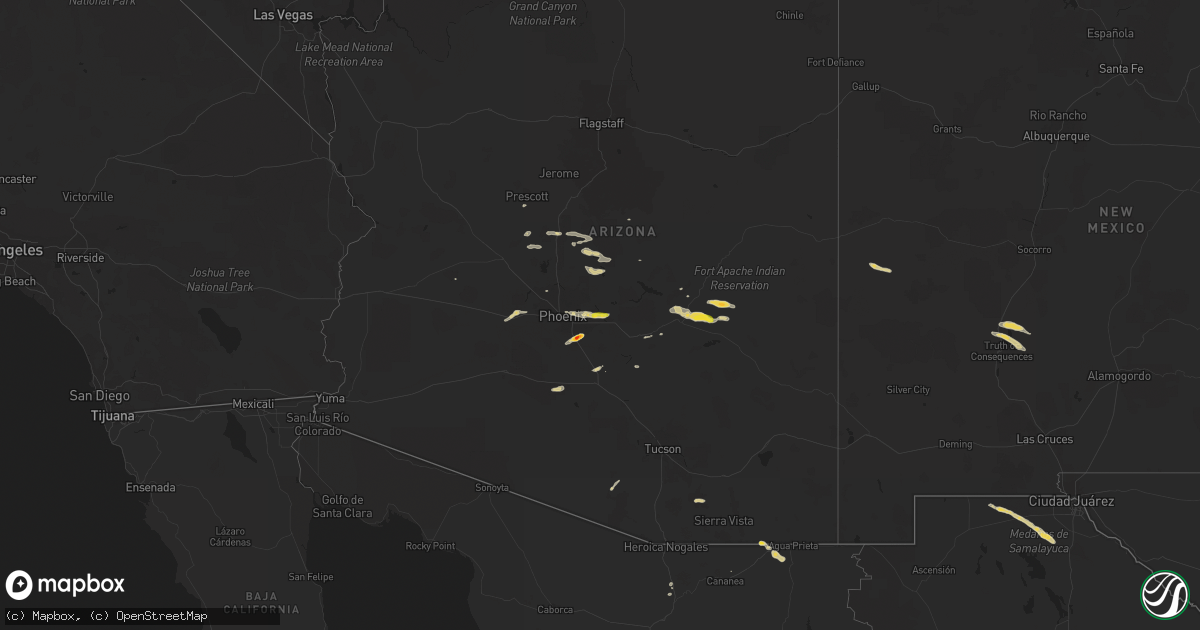
Hail Map on September 12, 2023
Get this storm
September 12 map
$229
one time, instant access
Download today. No call, no setup
Keep the $229
Bought the map and want the full workflow? Apply the entire $229 to a subscription within 7 days. None of it is wasted.
Every map, not just this one
This buys you this map. Subscription and you get every map we run, in the markets you choose from a few cities to whole states to nationwide. Plus real-time alerts the moment a storm fires.
Contact data
Name, contact info, occupancy, even credit band for addresses in the footprint. You go from where it hit to who to call.
Become the source they trust
Unlimited branding weather history reports on demand. You already have the documented answer ready for the property owner, and you are the one who showed up with it.
Property data and RoofTrace estimates
Pull up any address you have got, its value and the exact code rules for that jurisdiction, straight from One Click Code. Then RoofTrace estimates the squares, pitch, and roof value, priced the way you price.
States Impacted by Hail Map on September 12, 2023
Storm reports
Alabama
| Date | Description |
|---|---|
| 09/12/20235:38 PM CDT | Trees down on hwy 48 near randolph county high school. Time estimated by radar. |
| 09/12/20232:45 PM CDT | Trees down in the vicinity of recreative natives native plant nursery. Apparent downburst. |
| 09/11/20237:56 PM CDT | Trees down on floyd bradford rd in leeds. Time estimated by radar. |
| 09/11/20237:55 PM CDT | Corrects previous non-tstm wnd gst report from birmingham international airport. Asos station kbhm birmingham airport |
Virginia
| Date | Description |
|---|---|
| 09/12/20236:07 PM CDT | Multiple reports of trees down near and north of kenbridge. Time estimated via radar. |
| 09/12/20235:26 PM CDT | Thunderstorm winds blew down two trees near the intersection of farmville highway... Four locust highway... And kings highway. |
| 09/12/20235:02 PM CDT | Thunderstorm winds blew down one tree along the 1900 block of thomas jefferson highway. |
| 09/12/20234:55 PM CDT | Thunderstorm winds blew down one tree near the intersection of rolling hill road and price road. |
| 09/12/20234:54 PM CDT | Thunderstorm winds blew down one tree along the 300 block of church street. |
| 09/12/20234:53 PM CDT | Thunderstorm winds blew down one tree along the 300 block of berkley street. |
| 09/12/20234:50 PM CDT | Thunderstorm winds blew down one tree along the 1000 block of coles ferry road. |
| 09/12/20234:44 PM CDT | Thunderstorm winds blew down one tree along the 8000 block of midway road. |
| 09/12/20234:43 PM CDT | Thunderstorm winds blew down one tree along the 600 block of staunton hill road. |
| 09/12/20234:22 PM CDT | One tree blown down in chatham. |
| 09/12/20234:20 PM CDT | Metal roofing blown off at a trucking business along us 29 in dry fork. |
| 09/12/20232:59 PM CDT | Tree down at intersection of jubal early highway and teaberry loop. |
Tennessee
| Date | Description |
|---|---|
| 09/12/20234:45 PM CDT | A few trees down. |
| 09/12/20233:54 PM CDT | Trees down at newt road and washington college station road in the limestone area. Time estimated from radar. |
| 09/12/20233:50 PM CDT | Trees down at intersection of old state route 34 and taylor mill road near limestone. Time estimated from radar. |
| 09/12/20233:40 PM CDT | Trees down north and northeast of greeneville. Time estimated from radar. |
| 09/12/20233:30 PM CDT | Several trees down. |
| 09/12/20232:51 PM CDT | Several trees down. |
| 09/12/20232:08 PM CDT | Large limb down. |
Arizona
| Date | Description |
|---|---|
| 09/12/20235:22 PM CDT | Golf ball sized hail was reported near queen creek road and price road. |
| 09/12/20235:10 PM CDT | Multiple reports of power poles down near on maricopa rd west of i-10. Traffic signals out leading to significant traffic impacts. |
| 09/12/20234:03 AM CDT | Mesonet station qgta3 guthrie at sometime within 1:03 to 2:03 am. |
| 09/11/202311:13 PM CDT | Tree damage. Large limbs down and trees uprooted. Ceramic tiles on rooftops damaged. |
| 09/11/202311:10 PM CDT | Multiple large trees either snapped or uprooted. |
| 09/11/202311:10 PM CDT | Home weather station with 7 ft anemometer height. Recorded southwest winds with a maximum gust of 59 mph... Causing about 20 roof tiles to come off and other damage nea |
| 09/11/202311:05 PM CDT | Significant tree damage in the area along e mckellips rd. Large tree limbs down and several large trees uprooted. |
| 09/11/202311:00 PM CDT | Multiple small aircraft damaged... With some even completely flipped over. There was also significant roof damage to the hangar. |
| 09/11/202311:00 PM CDT | Multiple power poles down and on top of houses along recker rd. Between mcdowell and mckellips rd. |
| 09/11/202310:30 PM CDT | A very large uprooted tree knocked into a home in the area of 40th street and indian school road. |
| 09/11/202310:20 PM CDT | Power lines snapped at the intersection of n 17th st. And e oak st. |
| 09/11/20239:45 PM CDT | Large tree was uprooted. |
West Virginia
| Date | Description |
|---|---|
| 09/12/202312:15 PM CDT | Tree on power line. |
| 09/12/202312:10 PM CDT | Kanawha county metro 911 center received a report of a tree down in the 5400 block of elk river rd n in the clendenin/ falling rock area. One lane is blocked. Time esti |
| 09/12/202312:06 PM CDT | Tree on power line. |
| 09/12/202312:05 PM CDT | Tree on power line. |
| 09/12/202311:54 AM CDT | Kanawha county 911 advised there is a tree down in the 2800 block of trace fork rd in the davis creek area. Time estimated from radar. |
| 09/12/202311:38 AM CDT | Tree on power line. |
South Carolina
| Date | Description |
|---|---|
| 09/12/20234:40 PM CDT | Multiple downed trees at the intersection of whitmire hwy and beattys bridge rd. |
| 09/12/20233:57 PM CDT | At least one tree was blown down along with several large limbs. A limb was leaning or hanging on a power line but did not bring the power line down. |
| 09/12/20233:05 PM CDT | Spotter reports several trees blown down on walkingstick way. |
| 09/12/20232:45 PM CDT | 911 call center reported numerous trees down across the williamston and belton area. |
| 09/12/20232:16 PM CDT | Powerline down. Time estimated from radar. |
| 09/12/20231:35 PM CDT | Metal awning blew off and damaged part of the union high school roof. Also some large limbs down. |
| 09/12/20231:34 PM CDT | Social media report with photos and video showing garage door to a steel warehouse building blown down. Several slabs of granite also damaged on the loading dock. |
| 09/12/20231:30 PM CDT | Multiple trees down around peachtree road... With minor damage to outdoor structures. |
| 09/12/20231:30 PM CDT | Trees down and a trampoline launched onto a roof at residence on peachtree rd. |
| 09/12/202312:39 AM CDT | Colleton county emergency manager reported a tree down blocking both lanes at 1600 charleston highway. This was assoc |
| 09/12/202312:39 AM CDT | Colleton county emergency manager reported a tree down blocking both lanes at 1600 charleston highway. This was associated with the passage of a thunderstorm outflow. T |
| 09/11/202311:15 PM CDT | Colleton county emergency manager reported a tree down blocking one lane at the intersection of lumber road and sleepy hollow road. This was associated with the passage |
Florida
| Date | Description |
|---|---|
| 09/12/20231:50 PM CDT | Leon county law enforcement reported a tree down on a powerline on sunflower rd and celia rd or ct. |
Maryland
| Date | Description |
|---|---|
| 09/11/202311:58 PM CDT | A wind gust of 56 knots |
| 09/11/202311:36 PM CDT | Report of a tree downed on fox meadow road. Time estimated via radar. |
| 09/11/202311:36 PM CDT | Report of a tree downed on fox meadow road. Time estimated via radar. |
| 09/11/202311:35 PM CDT | A wind gust of 50 knots |
| 09/11/202311:21 PM CDT | Tree knocked down onto power pole at 2711 forge hill rd |
| 09/11/202311:08 PM CDT | A local report indicates 62 MPH wind near 1 N Baltimore Martin St |
| 09/11/202311:00 PM CDT | Large tree down at the intersection of ebenezer road & meyers ln. |
| 09/11/20239:48 PM CDT | Several trees blew down near silver spring and rockville. A tree blew down in the 1800 block of edgewater parkway. A tree blew down in the 9600 block of lawndale drive. |
| 09/11/20239:33 PM CDT | Trees blew down on md-193 river road near whittier boulevard/winston drive. |
| 09/11/20238:04 PM CDT | Several trees blew down between dickerson and darnestown. A tree blew down into the roadway in the 17900 block of moore road. A tree blew down on md-118 germantown road |
North Carolina
| Date | Description |
|---|---|
| 09/12/20235:35 PM CDT | Tree down on bunker hill road. |
| 09/12/20235:34 PM CDT | Tree down at cedar knoll circle and abbotts creek circle. |
| 09/12/20235:08 PM CDT | Power outages caused by a tree on power lines at w cone blvd and marston rd. |
| 09/12/20235:08 PM CDT | Tree down at wilshire dr and shamrock dr. |
| 09/12/20234:30 PM CDT | Report of trees down at shiloh rd and salisbury hwy in statesville. Time estimated from radar. |
Georgia
| Date | Description |
|---|---|
| 09/12/20236:50 PM CDT | Thunderstorm winds caused damage to a home off highway 301... Including multiple electric wires down. Time estimated by radar. |
| 09/12/20236:35 PM CDT | Tree down on knox rd caused by thunderstorm winds. Time estimated by radar. |
| 09/12/20235:28 PM CDT | A couple trees across powerlines in screven... Pea size hail reported on highway 84 and highway 203. Lightning struck house on sp |
| 09/12/20235:28 PM CDT | A couple trees across powerlines in screven... Pea size hail reported on highway 84 and highway 203. Lightning struck house on spring grove road. |
| 09/12/20234:25 PM CDT | Golf ball-size hail reported at intersection of mars hill rd and hadaway rd. |
| 09/12/20234:20 PM CDT | Half dollar-size hail reported at intersection of brookstone dr nw and mclain rd. |
| 09/12/20234:17 PM CDT | Report of quarter sized hail near mars hill rd and old stilesboro rd nw. |
| 09/12/20234:17 PM CDT | Golf ball sized hail reported at brookestone country club near brookstone dr nw and burnt hickory rd nw. |
| 09/12/20234:16 PM CDT | Report of quarter inch hail off of mary wallace way and royal sunset dr. |
| 09/12/20234:10 PM CDT | Quarter-size hail reported at intersection of cedarcrest rd and dallas acworth hwy. |
| 09/12/20234:00 PM CDT | Power lines and trees down in roadway of brooks rackley rd and wildwood way. |
| 09/12/20234:00 PM CDT | Trees and power lines down in intersection of due west rd and hwy 92. |
| 09/12/20233:55 PM CDT | Tree down at narroway church cir and abigail way. |
Cities Impacted by Hail Map on September 12, 2023
- Alum Creek, WV
- Gainesville, GA
- Dahlonega, GA
- Belton, SC
- Williamston, SC
- Pelzer, SC
- Afton, TN
- Greeneville, TN
- Dallas, GA
- Acworth, GA
- Kennesaw, GA
- Powder Springs, GA
- Marietta, GA
- Chandler, AZ
- Cisco, GA
- Bisbee, AZ
- Saint Cloud, FL
- Chuckey, TN
- Dawsonville, GA
- Farmville, VA
- Brookneal, VA
- Nathalie, VA
- Rutledge, TN
- Mosheim, TN
- Crandall, GA
- Old Fort, TN
- Washburn, TN
- Douglasville, GA
- Lithia Springs, GA
- Elgin, AZ
- Vail, AZ
- Jesup, GA
- Screven, GA
- Odum, GA
- Limestone, TN
- Sonoita, AZ
- Cartersville, GA
- Emerson, GA
- Nahunta, GA
- Apalachicola, FL
- Brasstown, NC
- Jasper, FL
- Thomasville, NC
- Birmingham, AL
- Mesa, AZ
- Apache Junction, AZ
- Middle River, MD
- Essex, MD
- Aragon, NM
- Reserve, NM
- Jacksonville, FL
- Webster, FL
- Great Falls, SC
- Winston Salem, NC
- Lexington, NC
- Hilliard, FL
- Red Oak, VA
- Randolph, VA
- Saxe, VA
- Truth Or Consequences, NM
- Rembert, SC
- Kensington, MD
- Silver Spring, MD
- Chevy Chase, MD
- Bethesda, MD
- Bryceville, FL
- Palatka, FL
- Patterson, GA
- Folkston, GA
- Hoboken, GA
- Pamplin, VA
- Prospect, VA
- Scottsdale, AZ
- White Oak, GA
- La Fayette, GA
- Buckeye, AZ
- Blackshear, GA
- Interlachen, FL
- Easton, MD
- Black Canyon City, AZ
- Florence, AZ
- Phoenix, AZ
- Cordova, MD
- Prescott, AZ
- Casa Grande, AZ
- Mayer, AZ
- Coolidge, AZ
- Tempe, AZ
- Cave Creek, AZ
- Dalzell, SC
- Peoria, AZ
- Litchfield Park, AZ
- Congress, AZ
- Cabin John, MD
- Globe, AZ
- Peridot, AZ
- Glen Echo, MD