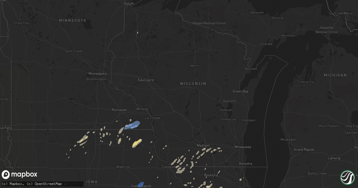
Hail Map in Wisconsin on September 12, 2019
Get this storm
September 12 map
$229
one time, instant access
Download today. No call, no setup
Keep the $229
Bought the map and want the full workflow? Apply the entire $229 to a subscription within 7 days. None of it is wasted.
Every map, not just this one
This buys you this map. Subscription and you get every map we run, in the markets you choose from a few cities to whole states to nationwide. Plus real-time alerts the moment a storm fires.
Contact data
Name, contact info, occupancy, even credit band for addresses in the footprint. You go from where it hit to who to call.
Become the source they trust
Unlimited branding weather history reports on demand. You already have the documented answer ready for the property owner, and you are the one who showed up with it.
Property data and RoofTrace estimates
Pull up any address you have got, its value and the exact code rules for that jurisdiction, straight from One Click Code. Then RoofTrace estimates the squares, pitch, and roof value, priced the way you price.
Storm reports in Wisconsin
Wisconsin
| Date | Description |
|---|---|
| 09/12/20193:14 AM CDT | At 813 PM CDT, a severe thunderstorm was located 7 miles southwest of Blanchardville, or 8 miles northeast of Darlington, moving northeast at 45 mph. HAZARD...60 mph wind gusts. SOURCE...Radar indicated. IMPACT...Expect damage to roofs, siding, and trees. Locations impacted include... Mount Horeb, Darlington, Belleville, New Glarus, Monticello, Argyle, Blanchardville, Barneveld, Blue Mounds, Dayton, Lamont, Hollandale, Blue Mound St Park, Mount Vernon and Yellowstone Lake St Park. |
| 09/12/20192:36 AM CDT | At 736 PM CDT, a severe thunderstorm was located over Hazel Green, or near Galena, moving northeast at 50 mph. HAZARD...60 mph wind gusts. SOURCE...Radar indicated. IMPACT...Expect damage to roofs, siding, and trees. Locations impacted include... Darlington, Shullsburg, Belmont, Benton, Somers, Wiota, New Diggings, Lamont, Gratiot, Yellowstone Lake St Park, Lead Mine and Woodford. |
| 09/12/20192:25 AM CDT | At 724 PM CDT, a severe thunderstorm was located 8 miles northeast of Muscoda, or 8 miles southeast of Richland Center, moving northeast at 30 mph. HAZARD...60 mph wind gusts. SOURCE...Radar indicated. IMPACT...Expect damage to roofs, siding, and trees. Locations impacted include... Spring Green, Plain, Avoca, Orion, Loganville, Lime Ridge, Leland and Hill Point. |
| 09/12/20191:16 AM CDT | At 615 PM CDT, a severe thunderstorm was located near Farmersburg, or 8 miles west of Prairie Du Chien, moving north at 35 mph. HAZARD...60 mph wind gusts. SOURCE...Radar indicated. Strong wind gusts to around 60 mph were also reported in Clayton Center around 6 PM. IMPACT...Expect damage to roofs, siding, and trees. This severe thunderstorm will be near... McGregor around 620 PM CDT. Prairie Du Chien and Marquette around 625 PM CDT. Harpers Ferry around 640 PM CDT.Other locations impacted by this severe thunderstorm include CountyRoads A 52 And X 52, Highway 35 And County D, Spook Cave Campground,Waterville, Giard, Watson and National. |
| 09/12/201912:36 AM CDT | At 535 PM CDT, a severe thunderstorm was located near Edgewood, or 12 miles northeast of Manchester, moving north at 40 mph. HAZARD...60 mph wind gusts. SOURCE...Public. This storm has produced wind damage across northern Delaware County. IMPACT...Expect damage to roofs, siding, and trees. This severe thunderstorm will be near... Guttenberg around 555 PM CDT. Garnavillo around 600 PM CDT. McGregor and Marquette around 615 PM CDT.Other locations impacted by this severe thunderstorm include CampC.S. Klaus, Mederville, Turkey River, Bixby State Park, Fairview,National and Pikes Peak State Park. |
| 09/11/20199:05 PM CDT | Report of multiple trees down. Time estimated by radar. |
| 09/11/20198:05 PM CDT | Several trees/large branches downed. |
All States Impacted by Hail Map on September 12, 2019
Cities Impacted by Hail Map on September 12, 2019
- Cheraw, SC
- Monticello, WI
- Belleville, WI
- Albany, WI
- Warsaw, IN
- Jefferson, WI
- Edgewood, IA
- Tonkawa, OK
- Happy, TX
- North Manchester, IN
- Elma, IA
- Ionia, IA
- Alta Vista, IA
- New Hampton, IA
- Charles City, IA
- Mutual, OK
- Vici, OK
- Seiling, OK
- Chester, OK
- Quitaque, TX
- Argyle, WI
- Geneseo, IL
- Medford, OK
- Americus, KS
- Emporia, KS
- Marion, IN
- Van Buren, IN
- Darlington, WI
- Shullsburg, WI
- Cuba City, WI
- Palatine, IL
- Arlington Heights, IL
- Buffalo Grove, IL
- Lake Zurich, IL
- Dixon, IL
- Oregon, IL
- Garber, OK
- Fairmont, OK
- Leedey, OK
- Billings, OK
- Tulia, TX
- Braman, OK
- Tatum, NM
- Mcdonald, NM
- Lovington, NM
- Logansport, IN
- Goltry, OK
- Enid, OK
- Lahoma, OK
- Carrier, OK
- Marathon, TX
- Wayside, TX
- Claude, TX
- Barneveld, WI
- South Wayne, WI
- Gratiot, WI
- Harmon, IL
- Saint Paul, KS
- Ossian, IA
- Calmar, IA
- Decorah, IA
- Postville, IA
- Waucoma, IA
- West Union, IA
- Fort Atkinson, IA
- Saint Lucas, IA
- Springbrook, WI
- Denver, IN
- Peru, IN
- Livermore, IA
- Chesterton, IN
- Portage, IN
- Hepler, KS
- Girard, KS
- Walnut, KS
- Jones, OK
- Harrah, OK
- Choctaw, OK
- Spencer, OK
- Cassatt, SC
- Monroe, WI
- Chadwick, IL
- Lanark, IL
- Valparaiso, IN
- Crystal Lake, IA
- Leland, IA
- Britt, IA
- Woden, IA
- Thompson, IA
- Forest City, IA
- Wesley, IA
- Arnett, OK
- Georgetown, DE
- Millsboro, DE
- Hawkeye, IA
- Castalia, IA
- Clarendon, TX
- Winona Lake, IN
- North Webster, IN
- Leesburg, IN
- Millersburg, IN
- Goshen, IN
- Sterling, IL
- Farlington, KS
- Fort Scott, KS
- Uniontown, KS
- Rose Hill, KS
- Stony Creek, VA
- Mason City, IA
- Osco, IL
- Redkey, IN
- Preston, MN
- Lanesboro, MN
- Fountain, MN
- North Liberty, IN
- Poplar Grove, IL
- Capron, IL
- Milledgeville, IL
- Canyon, TX
- Dimmitt, TX
- Lena, IL
- Mount Hope, WI
- Woodman, WI
- Ashton, IL
- Chana, IL
- Lindenwood, IL
- Rochelle, IL
- Blanchard, OK
- Newcastle, OK
- New Glarus, WI
- Elsmore, KS
- Moran, KS
- Norfolk, VA
- Waterman, IL
- Dekalb, IL
- Stoughton, WI
- Cambridge, WI
- Fulton, IL
- Clinton, IA
- Yorktown, TX
- Garner, IA
- Elkader, IA
- Pawnee, OK
- Mocksville, NC
- Osage, IA
- Buchanan, MI
- Algona, IA
- Floyd, IA
- Rockford, IA
- Kress, TX
- Fairfax, MO
- Burlington Junction, MO
- Grand Meadow, MN
- Parsons, KS
- Waukomis, OK
- Roanoke, IN
- Coyle, OK
- Cherokee, OK
- Milford, IN
- Craig, MO
- Fort Atkinson, WI
- Whitewater, WI
- Riceville, IA
- Muleshoe, TX
- Nappanee, IN
- Etna Green, IN
- Oregon, WI
- Mcfarland, WI
- Madison, WI
- Corwith, IA
- Belmond, IA
- Jefferson, IA
- Fredonia, KS
- Benedict, KS
- Cambridge, IL
- Ponca City, OK
- Protivin, IA
- Cresco, IA
- Ridgeway, IA
- Twelve Mile, IN
- Rochester, IN
- Boscobel, WI
- Taloga, OK
- Browntown, WI
- Winslow, IL
- Alexis, IL
- Gerlaw, IL
- Apple River, IL
- Stockton, IL
- Galena, IL
- Hanover, IL
- Warren, IL
- Scales Mound, IL
- Elizabeth, IL
- Monmouth, IL
- Charles City, VA
- Camanche, IA
- Cordova, IL
- Red Rock, OK
- Marland, OK
- Hobart, IN
- Merrillville, IN
- Crown Point, IN
- Lake Station, IN
- Gary, IN
- Edgerton, WI
- Alpha, IL
- New Windsor, IL
- Trego, WI
- Pond Creek, OK
- Lime Springs, IA
- Beloit, WI
- Fall River, KS
- Ridgeville, IN
- Portland, IN
- Dunkirk, IN
- Milnesand, NM
- Crossroads, NM
- Severy, KS
- Kremlin, OK
- Lamont, OK
- Hunter, OK
- New Kent, VA
- Quinton, VA
- Leon, KS
- Douglass, KS
- Belmont, WI
- Woosung, IL
- Polo, IL
- Rock Falls, IL
- Little York, IL
- Greeley, IA
- Chesapeake, VA
- Virginia Beach, VA
- Northwood, IA
- Lake Mills, IA
- Bedford, IA
- Clearmont, MO
- Compton, IL
- Steward, IL
- Jefferson, SC
- Mount Croghan, SC
- Fairfax, OK
- Ralston, OK
- Sharon, OK
- Byron, IL
- Ottosen, IA
- Bradgate, IA
- Mineral Point, WI
- Atlanta, KS
- Providence Forge, VA
- Dinwiddie, VA
- Carson, VA
- Holton, KS
- Perry, OK
- Harmony, MN
- Lyle, MN
- Austin, MN
- Cascade, IA
- Monticello, IA
- Oakwood, OK
- Cheyenne, OK
- Tampico, IL
- Prophetstown, IL
- South Haven, KS
- Brooklyn, WI
- Meridian, OK
- Guthrie, OK
- Bourbon, IN
- Garber, IA
- Guttenberg, IA
- Niles, MI
- Davis Junction, IL
- Helena, OK
- Wallace, SC
- Buffalo, KS
- Delmar, IA
- Maquoketa, IA
- Winnebago, IL
- La Fontaine, IN
- Harpers Ferry, IA
- Morrison, IL
- Lyndon, IL
- Erie, IL
- Walkerton, IN
- Chester, IA
- Le Roy, MN
- Spring Valley, MN
- Kensett, IA
- Jarratt, VA
- Enfield, NC
- Littleton, NC
- Halifax, NC
- New Paris, IN
- Mount Morris, IL
- Shannon, IL
- Saint Ansgar, IA
- Grafton, IA
- Deerfield, IL
- Lincolnshire, IL
- Osage City, KS
- Patrick, SC
- Gilmore City, IA
- Chesterfield, SC
- Manly, IA
- Plymouth, IA
- Hinckley, IL
- Hedley, TX
- Mount Carroll, IL
- Durand, IL
- Emporia, VA
- Yale, VA
- Humboldt, IA
- Glenville, MN
- Fairview, OK
- Maple Park, IL
- Cortland, IL
- Sycamore, IL
- Princeton, IL
- Ohio, IL
- Malta, IL
- Lee, IL
- Shabbona, IL
- Bode, IA
- San Pierre, IN
- Mulhall, OK
- Bartlett, KS
- Edna, KS
- Farwell, TX
- Hazel Green, WI
- Platteville, WI
- Thomson, IL
- Savanna, IL
- Drummond, OK
- Maramec, OK
- Cleveland, OK
- Mabel, MN
- Rushford, MN
- Peterson, MN
- Canton, MN
- Spring Grove, MN
- Houston, MN
- Robins, IA
- Palo, IA
- Hiawatha, IA
- Cedar Rapids, IA
- Marion, IA
- Dagsboro, DE
- Frankford, DE
- Weatherford, OK
- Corn, OK


