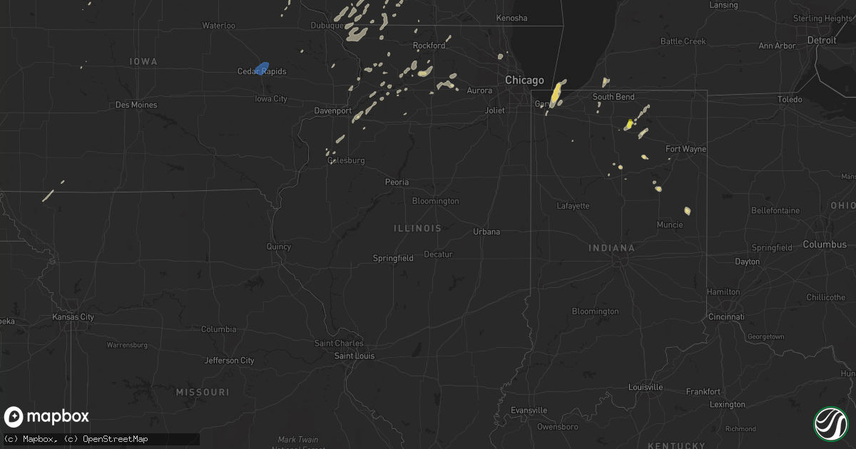
Hail Map in Illinois on September 12, 2019
Get this storm
September 12 map
$229
one time, instant access
Download today. No call, no setup
Keep the $229
Bought the map and want the full workflow? Apply the entire $229 to a subscription within 7 days. None of it is wasted.
Every map, not just this one
This buys you this map. Subscription and you get every map we run, in the markets you choose from a few cities to whole states to nationwide. Plus real-time alerts the moment a storm fires.
Contact data
Name, contact info, occupancy, even credit band for addresses in the footprint. You go from where it hit to who to call.
Become the source they trust
Unlimited branding weather history reports on demand. You already have the documented answer ready for the property owner, and you are the one who showed up with it.
Property data and RoofTrace estimates
Pull up any address you have got, its value and the exact code rules for that jurisdiction, straight from One Click Code. Then RoofTrace estimates the squares, pitch, and roof value, priced the way you price.
Storm reports in Illinois
Illinois
| Date | Description |
|---|---|
| 09/12/20196:58 AM CDT | At 1157 PM CDT, severe thunderstorms were located along a line extending from near Kirkland to near Ashton to near Amboy, moving east at 45 mph. HAZARD...60 mph wind gusts. SOURCE...Radar indicated. IMPACT...Expect damage to roofs, siding, and trees. Locations impacted include... Sycamore, Rochelle, Genoa, Shabbona, DeKalb, Cortland, Kirkland, Waterman, Hillcrest, Maple Park, Kingston, Malta, Paw Paw, Davis Junction, Creston, Sublette, Lee, Compton, Steward and West Brooklyn.Including the following interstates... I-39 between mile markers 78 and 114. I-88 between mile markers 71 and 101.This includes...Northern Illinois University. |
| 09/12/20196:28 AM CDT | At 1128 PM CDT, a severe thunderstorm was located near Rock Falls, moving northeast at 45 mph. HAZARD...60 mph wind gusts. SOURCE...Radar indicated. IMPACT...Expect damage to roofs, siding, and trees. Locations impacted include... Dixon, Oregon, Walton, Amboy, Franklin Grove, Ashton, Nelson and Harmon.Including the following interstate... I-88 between mile markers 45 and 71. This includes...Castle Rock State Park, Lee County Fairgrounds, and Sauk Valley College. |
| 09/12/20191:00 AM CDT | Photo shared via social media of large tree snapped near base in north barrington. Time estimated by radar. |
| 09/11/201910:06 PM CDT | At 305 PM CDT, a severe thunderstorm was located near Shabbona, moving northeast at 20 mph. HAZARD...60 mph wind gusts and quarter size hail. SOURCE...Radar indicated. IMPACT...Hail damage to vehicles is expected. Expect wind damage to roofs, siding, and trees. Locations impacted include... Sycamore, Genoa, Shabbona, DeKalb, Cortland, Maple Park, Malta, Kingston, Lee and Steward.Including the following interstates... I-39 between mile markers 89 and 96. I-88 between mile markers 83 and 101.This includes... Northern Illinois University. |
| 09/11/20199:09 PM CDT | Small branches down. |
All States Impacted by Hail Map on September 12, 2019
Cities Impacted by Hail Map on September 12, 2019
- Cheraw, SC
- Monticello, WI
- Belleville, WI
- Albany, WI
- Warsaw, IN
- Jefferson, WI
- Edgewood, IA
- Tonkawa, OK
- Happy, TX
- North Manchester, IN
- Elma, IA
- Ionia, IA
- Alta Vista, IA
- New Hampton, IA
- Charles City, IA
- Mutual, OK
- Vici, OK
- Seiling, OK
- Chester, OK
- Quitaque, TX
- Argyle, WI
- Geneseo, IL
- Medford, OK
- Americus, KS
- Emporia, KS
- Marion, IN
- Van Buren, IN
- Darlington, WI
- Shullsburg, WI
- Cuba City, WI
- Palatine, IL
- Arlington Heights, IL
- Buffalo Grove, IL
- Lake Zurich, IL
- Dixon, IL
- Oregon, IL
- Garber, OK
- Fairmont, OK
- Leedey, OK
- Billings, OK
- Tulia, TX
- Braman, OK
- Tatum, NM
- Mcdonald, NM
- Lovington, NM
- Logansport, IN
- Goltry, OK
- Enid, OK
- Lahoma, OK
- Carrier, OK
- Marathon, TX
- Wayside, TX
- Claude, TX
- Barneveld, WI
- South Wayne, WI
- Gratiot, WI
- Harmon, IL
- Saint Paul, KS
- Ossian, IA
- Calmar, IA
- Decorah, IA
- Postville, IA
- Waucoma, IA
- West Union, IA
- Fort Atkinson, IA
- Saint Lucas, IA
- Springbrook, WI
- Denver, IN
- Peru, IN
- Livermore, IA
- Chesterton, IN
- Portage, IN
- Hepler, KS
- Girard, KS
- Walnut, KS
- Jones, OK
- Harrah, OK
- Choctaw, OK
- Spencer, OK
- Cassatt, SC
- Monroe, WI
- Chadwick, IL
- Lanark, IL
- Valparaiso, IN
- Crystal Lake, IA
- Leland, IA
- Britt, IA
- Woden, IA
- Thompson, IA
- Forest City, IA
- Wesley, IA
- Arnett, OK
- Georgetown, DE
- Millsboro, DE
- Hawkeye, IA
- Castalia, IA
- Clarendon, TX
- Winona Lake, IN
- North Webster, IN
- Leesburg, IN
- Millersburg, IN
- Goshen, IN
- Sterling, IL
- Farlington, KS
- Fort Scott, KS
- Uniontown, KS
- Rose Hill, KS
- Stony Creek, VA
- Mason City, IA
- Osco, IL
- Redkey, IN
- Preston, MN
- Lanesboro, MN
- Fountain, MN
- North Liberty, IN
- Poplar Grove, IL
- Capron, IL
- Milledgeville, IL
- Canyon, TX
- Dimmitt, TX
- Lena, IL
- Mount Hope, WI
- Woodman, WI
- Ashton, IL
- Chana, IL
- Lindenwood, IL
- Rochelle, IL
- Blanchard, OK
- Newcastle, OK
- New Glarus, WI
- Elsmore, KS
- Moran, KS
- Norfolk, VA
- Waterman, IL
- Dekalb, IL
- Stoughton, WI
- Cambridge, WI
- Fulton, IL
- Clinton, IA
- Yorktown, TX
- Garner, IA
- Elkader, IA
- Pawnee, OK
- Mocksville, NC
- Osage, IA
- Buchanan, MI
- Algona, IA
- Floyd, IA
- Rockford, IA
- Kress, TX
- Fairfax, MO
- Burlington Junction, MO
- Grand Meadow, MN
- Parsons, KS
- Waukomis, OK
- Roanoke, IN
- Coyle, OK
- Cherokee, OK
- Milford, IN
- Craig, MO
- Fort Atkinson, WI
- Whitewater, WI
- Riceville, IA
- Muleshoe, TX
- Nappanee, IN
- Etna Green, IN
- Oregon, WI
- Mcfarland, WI
- Madison, WI
- Corwith, IA
- Belmond, IA
- Jefferson, IA
- Fredonia, KS
- Benedict, KS
- Cambridge, IL
- Ponca City, OK
- Protivin, IA
- Cresco, IA
- Ridgeway, IA
- Twelve Mile, IN
- Rochester, IN
- Boscobel, WI
- Taloga, OK
- Browntown, WI
- Winslow, IL
- Alexis, IL
- Gerlaw, IL
- Apple River, IL
- Stockton, IL
- Galena, IL
- Hanover, IL
- Warren, IL
- Scales Mound, IL
- Elizabeth, IL
- Monmouth, IL
- Charles City, VA
- Camanche, IA
- Cordova, IL
- Red Rock, OK
- Marland, OK
- Hobart, IN
- Merrillville, IN
- Crown Point, IN
- Lake Station, IN
- Gary, IN
- Edgerton, WI
- Alpha, IL
- New Windsor, IL
- Trego, WI
- Pond Creek, OK
- Lime Springs, IA
- Beloit, WI
- Fall River, KS
- Ridgeville, IN
- Portland, IN
- Dunkirk, IN
- Milnesand, NM
- Crossroads, NM
- Severy, KS
- Kremlin, OK
- Lamont, OK
- Hunter, OK
- New Kent, VA
- Quinton, VA
- Leon, KS
- Douglass, KS
- Belmont, WI
- Woosung, IL
- Polo, IL
- Rock Falls, IL
- Little York, IL
- Greeley, IA
- Chesapeake, VA
- Virginia Beach, VA
- Northwood, IA
- Lake Mills, IA
- Bedford, IA
- Clearmont, MO
- Compton, IL
- Steward, IL
- Jefferson, SC
- Mount Croghan, SC
- Fairfax, OK
- Ralston, OK
- Sharon, OK
- Byron, IL
- Ottosen, IA
- Bradgate, IA
- Mineral Point, WI
- Atlanta, KS
- Providence Forge, VA
- Dinwiddie, VA
- Carson, VA
- Holton, KS
- Perry, OK
- Harmony, MN
- Lyle, MN
- Austin, MN
- Cascade, IA
- Monticello, IA
- Oakwood, OK
- Cheyenne, OK
- Tampico, IL
- Prophetstown, IL
- South Haven, KS
- Brooklyn, WI
- Meridian, OK
- Guthrie, OK
- Bourbon, IN
- Garber, IA
- Guttenberg, IA
- Niles, MI
- Davis Junction, IL
- Helena, OK
- Wallace, SC
- Buffalo, KS
- Delmar, IA
- Maquoketa, IA
- Winnebago, IL
- La Fontaine, IN
- Harpers Ferry, IA
- Morrison, IL
- Lyndon, IL
- Erie, IL
- Walkerton, IN
- Chester, IA
- Le Roy, MN
- Spring Valley, MN
- Kensett, IA
- Jarratt, VA
- Enfield, NC
- Littleton, NC
- Halifax, NC
- New Paris, IN
- Mount Morris, IL
- Shannon, IL
- Saint Ansgar, IA
- Grafton, IA
- Deerfield, IL
- Lincolnshire, IL
- Osage City, KS
- Patrick, SC
- Gilmore City, IA
- Chesterfield, SC
- Manly, IA
- Plymouth, IA
- Hinckley, IL
- Hedley, TX
- Mount Carroll, IL
- Durand, IL
- Emporia, VA
- Yale, VA
- Humboldt, IA
- Glenville, MN
- Fairview, OK
- Maple Park, IL
- Cortland, IL
- Sycamore, IL
- Princeton, IL
- Ohio, IL
- Malta, IL
- Lee, IL
- Shabbona, IL
- Bode, IA
- San Pierre, IN
- Mulhall, OK
- Bartlett, KS
- Edna, KS
- Farwell, TX
- Hazel Green, WI
- Platteville, WI
- Thomson, IL
- Savanna, IL
- Drummond, OK
- Maramec, OK
- Cleveland, OK
- Mabel, MN
- Rushford, MN
- Peterson, MN
- Canton, MN
- Spring Grove, MN
- Houston, MN
- Robins, IA
- Palo, IA
- Hiawatha, IA
- Cedar Rapids, IA
- Marion, IA
- Dagsboro, DE
- Frankford, DE
- Weatherford, OK
- Corn, OK


